
Karst is a topography formed from the dissolution of soluble carbonate rocks such as limestone, dolomite, and gypsum. It is characterized by features like poljes above and drainage systems with sinkholes and caves underground. More weathering-resistant rocks, such as quartzite, can also occur, given the right conditions.

An aquifer is an underground layer of water-bearing material, consisting of permeable or fractured rock, or of unconsolidated materials. Aquifers vary greatly in their characteristics. The study of water flow in aquifers and the characterization of aquifers is called hydrogeology. Related terms include aquitard, which is a bed of low permeability along an aquifer, and aquiclude, which is a solid, impermeable area underlying or overlying an aquifer, the pressure of which could lead to the formation of a confined aquifer. The classification of aquifers is as follows: Saturated versus unsaturated; aquifers versus aquitards; confined versus unconfined; isotropic versus anisotropic; porous, karst, or fractured; transboundary aquifer.
Subsidence is a general term for downward vertical movement of the Earth's surface, which can be caused by both natural processes and human activities. Subsidence involves little or no horizontal movement, which distinguishes it from slope movement.

A sinkhole is a depression or hole in the ground caused by some form of collapse of the surface layer. The term is sometimes used to refer to doline, enclosed depressions that are also known as shakeholes, and to openings where surface water enters into underground passages known as ponor, swallow hole or swallet. A cenote is a type of sinkhole that exposes groundwater underneath. Sink and stream sink are more general terms for sites that drain surface water, possibly by infiltration into sediment or crumbled rock.
Landforms are categorized by characteristic physical attributes such as their creating process, shape, elevation, slope, orientation, rock exposure, and soil type.

A cenote is a natural pit, or sinkhole, resulting when a collapse of limestone bedrock exposes groundwater. The term originated on the Yucatán Peninsula of Mexico, where the ancient Maya commonly used cenotes for water supplies, and occasionally for sacrificial offerings. The name derives from a word used by the lowland Yucatec Maya—tsʼonoʼot—to refer to any location with accessible groundwater.

In geology, a depression is a landform sunken or depressed below the surrounding area. Depressions form by various mechanisms.

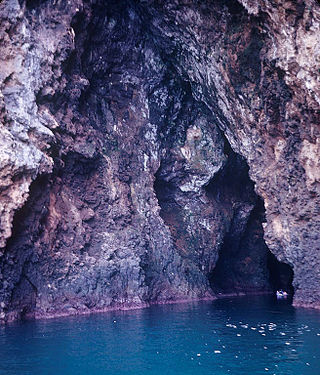
A blue hole is a large marine cavern or sinkhole, which is open to the surface and has developed in a bank or island composed of a carbonate bedrock. Blue holes typically contain tidally influenced water of fresh, marine, or mixed chemistry. They extend below sea level for most of their depth and may provide access to submerged cave passages. Well-known examples are the Dragon Hole and, in the Caribbean, the Great Blue Hole and Dean's Blue Hole.
Internal erosion is the formation of voids within a soil caused by the removal of material by seepage. It is the second most common cause of failure in levees and one of the leading causes of failures in earth dams, responsible for about half of embankment dam failures.
A sea cave, also known as a littoral cave, is a type of cave formed primarily by the wave action of the sea. The primary process involved is erosion. Sea caves are found throughout the world, actively forming along present coastlines and as relict sea caves on former coastlines. Some of the largest wave-cut caves in the world are found on the coast of Norway, but are now 100 feet or more above present sea level. These would still be classified as littoral caves. By contrast, in places like Thailand's Phang Nga Bay, solutionally formed caves in limestone have been flooded by the rising sea and are now subject to littoral erosion, representing a new phase of their enlargement.

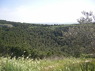
The Altopiano delle Murge is a karst topographic plateau of rectangular shape in southern Italy. Most of it lies within Puglia and corresponds with the sub-region known as Murgia or Le Murge. The plateau lies mainly in the Metropolitan City of Bari and the province of Barletta-Andria-Trani, but extends into the provinces of Brindisi and Taranto to the south, and into Matera in Basilicata to the west. The name is believed to originate from the Latin: murex, meaning 'sharp stone'.

The Eramosa Karst is a provincially significant Earth Science Area of Natural and Scientific Interest in Ontario, Canada, located in Stoney Creek, a constituent community of the City of Hamilton, and immediately south of the Niagara Escarpment.

A ponor is a natural opening where surface water enters into underground passages; they may be found in karst landscapes where the geology and the geomorphology is typically dominated by porous limestone rock. Ponors can drain stream or lake water continuously or can at times work as springs, similar to estavelles. Morphologically, ponors come in forms of large pits and caves, large fissures and caverns, networks of smaller cracks, and sedimentary, alluvial drains.
Škocjan Caves Regional Park is located in the Škocjan Karst, a vast flat landscape that lies at an elevation between 420 and 450 m in the southeast part of the Karst area. Following its independence, the Slovenia committed itself to protecting the Škocjan Caves area; for this reason, it established Škocjan Caves Regional Park and its managing authority, the Škocjan Caves Park Public Service Agency.

Uvala is originally a local toponym used by people in some regions in Slovenia, Croatia, Bosnia and Herzegovina, Montenegro and Serbia. In geosciences it denotes a closed karst depression, a terrain form usually of elongated or compound structure and of larger size than that of sinkholes. It is a morphological form frequently found in the outer Dinaric Alps anywhere between Slovenia and Greece, but large closed karst depressions are found on all continents in different landscapes and therefore uvala has become a globally established term. It is also used to distinguish such depressions from poljes, which are many square kilometres in size. Definitions of uvalas are often poorly empirically supported. "The coalescence of dolines" (sinkholes) is the dominant and most frequently found definition. However, because of the ongoing dissatisfaction with this definition, the term 'uvala' has often been belittled – occasionally it was even proposed that the term be given up altogether.
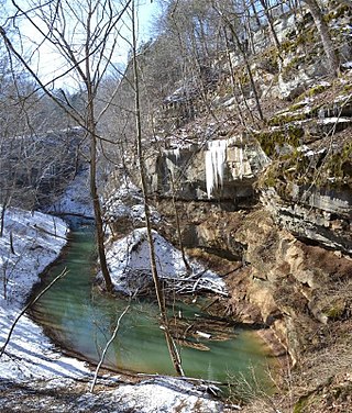
Cedar Sink is a vertical-walled large depression, or sinkhole, in the ground, that is located in Edmonson County, Kentucky and contained within and managed by Mammoth Cave National Park. The sinkhole measures 300 feet (91.4 m) from the top sandstone plateau to the bottom of the sink and was caused by collapse of the surface soil. The landscape is karst topography, which means the region is influenced by the dissolution of soluble rocks. Sinkholes, caves, and dolines typically characterize these underground drainage systems. Cedar Sink has a bottom area of about 7 acres (2.8 ha) and has more fertile soil compared to the ridgetops.

Pulo di Altamura is a doline located on the Murge plateau. It is the largest doline in that region and it is located about 6 kilometers (3.7 mi) north-west of the city of Altamura. It shares the local toponym pulo with other large dolines of the region, i.e. Pulicchio di Gravina, Pulo di Molfetta and Pulicchio di Toritto.
Pulicchio di Gravina is the second-largest doline in the Murge plateau after Pulo di Altamura. It falls into the territory of Gravina in Puglia, located about 10 kilometers (6.2 mi) north of the latter, close to the border with Altamura's territory. It shares the local toponym pulo with other large dolines of the region, i.e. Pulo di Altamura, Pulo di Molfetta and Pulicchio di Toritto.

A fissure is a long, narrow crack opening along the surface of Earth. The term is derived from the Latin word fissura, which means 'cleft' or 'crack'. Fissures emerge in Earth's crust, on ice sheets and glaciers, and on volcanoes.
