
Carter County is a county located in the U.S. state of Tennessee. As of the 2010 census, the population was 57,424. Its county seat is Elizabethton. The county is named in honor of Landon Carter (1760-1800), an early settler active in the "Lost State of Franklin" 1784-1788 secession from the State of North Carolina.

Watauga County is a county located in the U.S. state of North Carolina. As of the 2010 census, the population was 51,079. Its county seat and largest town is Boone. The county is in an exceptionally mountainous region. It is the home of Appalachian State University, which has approximately 20,023 students as of August 20, 2020. Watauga County comprises the Boone, NC Micropolitan Statistical Area.
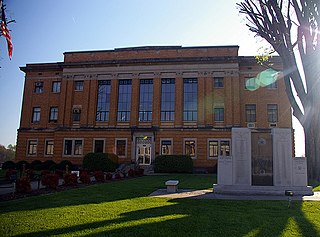
McDowell County is a county located in the U.S. state of North Carolina. As of the 2010 census, the population was 44,996. Its county seat is Marion.
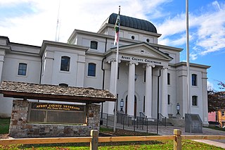
Avery County is a county located in the U.S. state of North Carolina. As of the 2010 census, the population was 17,797. The county seat is Newland. The county seat was initially established in Elk Park when the county was first formed, but was moved to Newland upon completion of the courthouse in 1912. Founded in 1911, it is the youngest of North Carolina's 100 counties.

Valle Crucis in an unincorporated community and census-designated place located in Watauga County, North Carolina, United States. The name of the town is Latin for "Vale of the Cross," a reference to a valley in the area where three streams converge to form a shape similar to an archbishop's cross. The community is located along NC 194, between the towns of Banner Elk and Boone.
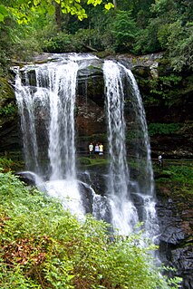
The Cullasaja River is a short river located entirely in Macon County, North Carolina. It is a tributary of the Little Tennessee River into which it flows near the county seat of Franklin.

The Nolichucky River is a 115-mile (185 km) river that flows through Western North Carolina and East Tennessee, in the southeastern United States. Traversing the Pisgah National Forest and the Cherokee National Forest in the Blue Ridge Mountains, the river's watershed is home to some of the highest mountains in the Appalachians, including Mount Mitchell in North Carolina, the highest point in the eastern United States. The river is a tributary of the French Broad River, and is impounded by Nolichucky Dam near Greeneville, Tennessee.

The Overmountain Men were American frontiersmen from west of the Appalachian Mountains who took part in the American Revolutionary War. While they were present at multiple engagements in the war's southern campaign, they are best known for their role in the American victory at the Battle of Kings Mountain in 1780. The term "overmountain" arose because their settlements were west of, or "over", the Appalachians, which was the primary geographical boundary dividing the 13 American colonies from the western frontier. The Overmountain Men hailed from parts of Virginia, North Carolina, and what is now Tennessee and Kentucky.

The Sycamore Shoals of the Watauga River, usually shortened to Sycamore Shoals, is a rocky stretch of river rapids along the Watauga River in Elizabethton, Tennessee. Archeological excavations have found Native Americans lived near the shoals since prehistoric times, and Cherokees gathered there. As Europeans began settling the Trans-Appalachian frontier, the shoals proved strategic militarily, as well as shaped the economies of Tennessee and Kentucky. Today, the shoals are protected as a National Historic Landmark and are maintained as part of Sycamore Shoals State Historic Park.

Bryan Grimes was a North Carolina planter and a general officer in the Confederate Army during the American Civil War. He fought in nearly all of the major battles of the Eastern Theater of that war.

Hazel Creek is a tributary stream of the Little Tennessee River in the southwestern Great Smoky Mountains of North Carolina. The creek's bottomlands were home to several pioneer Appalachian communities and logging towns before its incorporation into the Great Smoky Mountains National Park. Hazel Creek is now a back country campsite and historical area.

Hampton is an unincorporated community in Carter County, Tennessee, United States. Located a few miles southeast of Elizabethton and northwest of Roan Mountain, Hampton is surrounded on all sides by the Unaka Mountains. It is part of the Johnson City Metropolitan Statistical Area, which is a component of the Johnson City–Kingsport–Bristol, TN-VA Combined Statistical Area – commonly known as the "Tri-Cities" region.

Liendo Plantation is an historic cotton plantation in Waller County, Texas, United States. Named after its original owner, José Justo Liendo, the plantation was purchased in 1873 by sculptor Elisabet Ney and her husband, physician Edmund Montgomery.
Tuxedo is an unincorporated community in Henderson County, North Carolina, United States, which was originally called Lakewood.

Snake Mountain is a mountain located along the border between North Carolina and Tennessee, east of the community of Zionville, in the southeastern United States. It is part of the Blue Ridge Mountains, and includes parts of Watauga County, North Carolina, and Johnson County, Tennessee. It has two peaks, the highest of which reaches an elevation of 5,564 feet (1,696 m). The lower peak, at 5,518 feet (1,682 m), is Johnson County's high point.
Rich Mountain Bald is a mountain in the North Carolina High Country, southeast of the community of Zionville. Its elevation reaches 5,361 feet (1,634 m).

Ward Family House is a historic home located near Sugar Grove, Watauga County, North Carolina. It was built about 1897, and is a two-story, Queen Anne style frame dwelling. It is sheathed in novelty German siding and gables with five rows of diamond-edge wood shingles. Atop the roof is a cupola located between asymmetrically placed brick chimneys with stucco panels. A one-story rear ell was added in the 1980s.
Ben Farthing Farm is a historic farm and national historic district located near Sugar Grove, Watauga County, North Carolina. The complex includes a modest 1 1/2-story frame bungalow (1923), a large frame bank barn of traditional gambrel-roof form (1935), a root cellar built into a mountainside (1938), a frame outhouse (1938), and a frame scale house (1941). The buildings are set in a vernacular landscaping of native rock (1939).
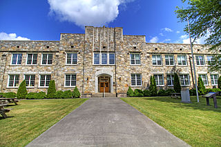
Cove Creek High School, also known as the Cove Creek Elementary School, is a historic high school building located at Sugar Grove, Watauga County, North Carolina. It was built by the Works Progress Administration in 1940–1941, and is a two-story, Collegiate Gothic style stone building. It is seven bays wide and features slightly projecting square stair towers and a crenellated roof parapet. It was designed by Clarence R. Coffey, an apprentice of Frank Lloyd Wright, and constructed by local artisans and laborers using local stone and wood sources.


