Sutherland, Iowa | |
---|---|
Coordinates: 42°58′21″N95°29′49″W / 42.97250°N 95.49694°W Coordinates: 42°58′21″N95°29′49″W / 42.97250°N 95.49694°W | |
Country | United States |
State | Iowa |
County | O'Brien |
Government | |
• Type | Mayor-council |
Area | |
• Total | 0.85 sq mi (2.20 km2) |
• Land | 0.85 sq mi (2.20 km2) |
• Water | 0.00 sq mi (0.00 km2) |
Elevation | 1,427 ft (435 m) |
Population (2020) | |
• Total | 629 |
• Density | 740.00/sq mi (285.87/km2) |
Time zone | UTC-6 (Central (CST)) |
• Summer (DST) | UTC-5 (CDT) |
ZIP code | 51058 |
Area code | 712 |
FIPS code | 19-76485 |
GNIS feature ID | 0462123 |
Website | City of Sutherland |
Sutherland is a city in O'Brien County, Iowa, United States. The population was 629 at the time of the 2020 census. [2]
Sutherland was laid out in 1882. [3] The city was named after the Duke of Sutherland. [4]
Sutherland is located at 42°58′21″N95°29′49″W / 42.972364°N 95.496923°W (42.972364, -95.496923). [5]
According to the United States Census Bureau, the city has a total area of 0.87 square miles (2.25 km2), all land. [6]
Census | Pop. | Note | %± |
---|---|---|---|
1890 | 490 | — | |
1900 | 722 | 47.3% | |
1910 | 664 | −8.0% | |
1920 | 876 | 31.9% | |
1930 | 802 | −8.4% | |
1940 | 875 | 9.1% | |
1950 | 835 | −4.6% | |
1960 | 883 | 5.7% | |
1970 | 875 | −0.9% | |
1980 | 897 | 2.5% | |
1990 | 714 | −20.4% | |
2000 | 707 | −1.0% | |
2010 | 649 | −8.2% | |
2020 | 629 | −3.1% | |
U.S. Decennial Census [7] [2] |
As of the census [8] of 2010, there were 649 people, 293 households, and 176 families living in the city. The population density was 746.0 inhabitants per square mile (288.0/km2). There were 353 housing units at an average density of 405.7 per square mile (156.6/km2). The racial makeup of the city was 98.8% White, 0.2% African American, 0.6% Native American, and 0.5% from two or more races. Hispanic or Latino of any race were 0.6% of the population.
There were 293 households, of which 22.2% had children under the age of 18 living with them, 48.8% were married couples living together, 6.1% had a female householder with no husband present, 5.1% had a male householder with no wife present, and 39.9% were non-families. 36.2% of all households were made up of individuals, and 15.3% had someone living alone who was 65 years of age or older. The average household size was 2.11 and the average family size was 2.68.
The median age in the city was 50.4 years. 19.6% of residents were under the age of 18; 4.1% were between the ages of 18 and 24; 19.1% were from 25 to 44; 31.4% were from 45 to 64; and 25.9% were 65 years of age or older. The gender makeup of the city was 49.2% male and 50.8% female.
As of the census [9] of 2000, there were 707 people, 315 households, and 200 families living in the city. The population density was 810.2 inhabitants per square mile (312.8/km2). There were 348 housing units at an average density of 398.8 per square mile (154.0/km2). The racial makeup of the city was 98.44% White, 0.14% African American, 0.71% Native American, 0.28% from other races, and 0.42% from two or more races. Hispanic or Latino of any race were 0.42% of the population.
There were 315 households, out of which 22.2% had children under the age of 18 living with them, 52.4% were married couples living together, 7.0% had a female householder with no husband present, and 36.5% were non-families. 33.7% of all households were made up of individuals, and 21.3% had someone living alone who was 65 years of age or older. The average household size was 2.15 and the average family size was 2.71.
In the city, the population was spread out, with 20.2% under the age of 18, 5.7% from 18 to 24, 20.5% from 25 to 44, 22.5% from 45 to 64, and 31.1% who were 65 years of age or older. The median age was 47 years. For every 100 females, there were 87.5 males. For every 100 females age 18 and over, there were 82.5 males.
The median income for a household in the city was $31,985, and the median income for a family was $39,250. Males had a median income of $30,000 versus $19,432 for females. The per capita income for the city was $16,345. About 2.0% of families and 3.9% of the population were below the poverty line, including 1.6% of those under age 18 and 3.8% of those age 65 or over.
Sutherland is served by the South O'Brien Community School District. [10] The district was formed on July 1, 1993 by the merger of three school districts: Paullina, Primghar, and Sutherland. [11]
Moulton is a city in Appanoose County, Iowa, United States. The population was 607 at the time of the 2020 census.
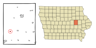
Keystone is a city in Benton County, Iowa, United States. The population was 599 at the time of the 2020 census. It is part of the Cedar Rapids Metropolitan Statistical Area.
Bristow is a city in Butler County, Iowa, United States. The population was 145 at the 2020 census.
Larrabee is a city in Cherokee County, Iowa, United States. The population was 123 at the time of the 2020 census.
Marcus is a city in Cherokee County, Iowa, United States. The population was 1,079 at the time of the 2020 census.
Garber is a city in Clayton County, Iowa, United States. The population was 76 at the time of the 2020 census, down from 103 in 2000.
St. Olaf is a city in Clayton County, Iowa, United States. The population was 106 at the time of the 2020 census, down from 136 in 2000. Swiss Valley has a large cheese packaging plant in St. Olaf.
Charter Oak is a city in Crawford County, Iowa, United States, along the East Soldier River. The population was 535 at the 2020 census.
Luxemburg is a city in Dubuque County, Iowa, United States. It is part of the Dubuque, Iowa Metropolitan Statistical Area. The population was 245 at the time of the 2020 census, down from 246 in 2000. The White Pine Hollow State Forest is located four miles to the northwest of Luxemburg.
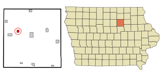
Maynard is a city in Fayette County, Iowa, United States. The population was 476 at the time of the 2020 census.
Buckeye is a city in Hardin County, Iowa, United States. The population was 86 at the time of the 2020 census.
Mondamin is a city in Harrison County, Iowa, United States. The population was 339 at the time of the 2020 census.
Prairieburg is a city in Linn County, Iowa, United States. The population was 160 at the time of the 2020 census. It is part of the Cedar Rapids Metropolitan Statistical Area.
Calumet is a city in O'Brien County, Iowa, United States. The population was 146 at the 2020 census.
Paullina is a city in O'Brien County, Iowa, United States. The population was 982 at the 2020 census.
Primghar is a city in, and the county seat of, O'Brien County, Iowa, United States. The population was 896 at the time of the 2020 census. Primghar is 23.5 miles south of Iowa State Highway 9, 28 miles east of Sioux Center and 6.75 miles north of Iowa State Highway 10.
Sanborn is a city in O'Brien County, Iowa, United States. The population was 1,392 at the time of the 2020 census.
Melvin is a city in Osceola County, Iowa, United States. The population was 199 at the time of the 2020 census.
Dixon is a city in Scott County, Iowa, United States. The population was 202 at the time of the 2020 census.
Vincent is a city in Webster County, Iowa, United States. The population was 130 at the time of the 2020 census.