Switzer, West Virginia

Last updated
Switzer, West Virginia
WVMap-doton-Switzer.PNG
Location of Switzer, West Virginia
Coordinates: 37°47′37″N81°59′15″W / 37.79361°N 81.98750°W / 37.79361; -81.98750 Coordinates: 37°47′37″N81°59′15″W / 37.79361°N 81.98750°W / 37.79361; -81.98750
Country United States
State West Virginia
County Logan
Area
[1]
  Total2.36 sq mi (6.12 km2)
  Land2.34 sq mi (6.06 km2)
  Water0.02 sq mi (0.06 km2)
Elevation
745 ft (227 m)
Population
 (2010) [2]
  Total595
  Density254/sq mi (98.2/km2)
Time zone UTC-5 (Eastern (EST))
  Summer (DST) UTC-4 (EDT)
ZIP code
25647
Area code(s) 304
FIPS code 54-78796 [3]
GNIS feature ID1555771 [4]

Switzer is an unincorporated community and census-designated place (CDP) in Logan County, West Virginia, United States. The CDP includes the neighboring unincorporated community of Micco. The total CDP population was 595 at the 2010 census. [2]

Contents

The community was, most likely, named after the local Switzer family. [5] [6]

Geography

Switzer is located in southwestern Logan County along Island Creek and West Virginia Route 44. [7] The CDP is bordered to the north by Rossmore and to the south by Chauncey. Via WV-44, it is 6 miles (10 km) north to Logan, the county seat.

According to the United States Census Bureau, the Switzer CDP has a total area of 2.4 square miles (6.1 km2), of which 0.02 square miles (0.06 km2), or 1.02%, are water. [1] Via Island Creek, Switzer is part of the Guyandotte River watershed, flowing north to the Ohio River near Huntington.

Demographics

At the 2000 census there were 1,138 people, 466 households, and 322 families in the CDP. The population density was 118.3 people per square mile (45.7/km2). There were 537 housing units at an average density of 55.8/sq mi (21.6/km2). The racial makeup of the CDP was 95.78% White, 3.08% African American, 0.18% Native American, 0.09% Asian, 0.09% from other races, and 0.79% from two or more races. Hispanic or Latino of any race were 0.97%. [3]

Of the 466 households 31.1% had children under the age of 18 living with them, 48.9% were married couples living together, 17.8% had a female householder with no husband present, and 30.9% were non-families. 27.3% of households were one person and 13.3% were one person aged 65 or older. The average household size was 2.44 and the average family size was 2.96.

The age distribution was 24.0% under the age of 18, 10.5% from 18 to 24, 27.2% from 25 to 44, 24.2% from 45 to 64, and 14.1% 65 or older. The median age was 38 years. For every 100 females, there were 82.1 males. For every 100 females age 18 and over, there were 78.7 males.

The median household income was $21,806 and the median family income was $30,341. Males had a median income of $33,125 versus $22,054 for females. The per capita income for the CDP was $13,410. About 17.4% of families and 23.3% of the population were below the poverty line, including 30.3% of those under age 18 and 18.6% of those age 65 or over.

Switzer, West Virginia.jpg
Route 44 in Switzer

Related Research Articles

Logan County, West Virginia U.S. county in West Virginia

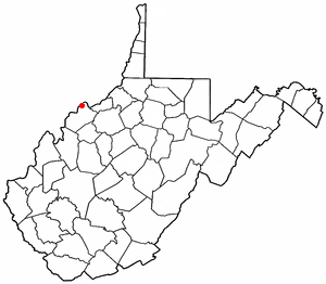
Logan County is a county in the U.S. state of West Virginia. As of the 2010 census, the population was 36,743. Its county seat is Logan. Logan County comprises the Logan, WV Micropolitan Statistical Area, which is also included in the Charleston–Huntington–Ashland, WV–OH–KY Combined Statistical Area.

Pea Ridge, West Virginia Census-designated place in West Virginia, United States

Pea Ridge is a census-designated place (CDP) in Cabell County, West Virginia, United States. As of the 2010 census, the population was 6,650.

Alum Creek, West Virginia Census-designated place in West Virginia, United States

Alum Creek is a census-designated place (CDP) in Kanawha and Lincoln counties along the Coal River in the U.S. state of West Virginia. It includes the unincorporated communities of Alum Creek, Forks of Coal, and Priestley. The CDP had a population of 1,749 at the 2010 census, down from 1,839 at the 2000 census.

Harts, West Virginia Census-designated place in West Virginia, United States

Harts is a census-designated place (CDP) at the mouth of Big Harts Creek in Lincoln County, West Virginia, United States, along the Guyandotte River. As of the 2010 census, its population was 656. Harts is a part of the Huntington-Ashland, WV-KY-OH, Metropolitan Statistical Area (MSA). The Harts CDP includes the unincorporated communities of Harts, Atenville, Ferrellsburg, and Sand Creek.

Holden, West Virginia Census-designated place in West Virginia, United States

Holden is a census-designated place (CDP) in Logan County, West Virginia, United States. The population was 876 at the 2010 census, down from 1,105 at the 2000 census. The CDP contains the unincorporated communities of Holden, Beebe, Frogtown, Sycamore, Diamond, and Davis, all in the valley of Copperas Mine Fork.

Logan, West Virginia City in West Virginia, United States

Logan is a city in Logan County, West Virginia, United States, along the Guyandotte River. The population was 1,779 at the 2010 census. It is the county seat of Logan County.

Mallory, West Virginia Census-designated place in West Virginia, United States

Mallory is a census-designated place (CDP) in Logan County, West Virginia, United States. The population was 1,654 at the 2010 census. The CDP contains the unincorporated communities, from west to east, of Huff Junction, Mallory, Davin, Mineral City, Claypool, Combs Addition, and Gillman Bottom.

Man, West Virginia Town in West Virginia, United States

Man is a town in Logan County, West Virginia, United States. The population was 759 at the 2010 census. The town is located along the Guyandotte River at the mouth of Buffalo Creek, which was the site of the 1972 Buffalo Creek Flood following a dam collapse. The name of the town reportedly derives from the last syllable of the surname of Ulysses Hinchman, who was a member of the House of Delegates from Logan County between 1866 and 1869.

Mount Gay-Shamrock, West Virginia Census-designated place in West Virginia, United States

Mount Gay-Shamrock is a census-designated place (CDP) in Logan County, West Virginia, United States. The population was 1,779 at the 2010 census. The CDP includes the unincorporated communities of Mount Gay, Shamrock, Black Bottom, Whites Addition, Lintz Addition, Thompson Town, Hedgeview, Ridgeview, Logan Heights, Cora, and Whitman Junction.

Wiley Ford, West Virginia CDP in West Virginia, United States

Wiley Ford is a census-designated place (CDP) in Mineral County, West Virginia, United States and part of the 'Cumberland, MD-WV Metropolitan Statistical Area'. The population was 1,026 at the 2010 census.

Chattaroy, West Virginia Census-designated place in West Virginia, United States

Chattaroy is a census-designated place (CDP) in Mingo County, West Virginia, United States. The population was 756 at the 2010 census.

Craigsville, West Virginia CDP in West Virginia, United States

Craigsville is a census-designated place (CDP) in Nicholas County, West Virginia, United States. The population was 2,213 at the 2010 census.

Teays Valley, West Virginia CDP in West Virginia, United States

Teays Valley is a census-designated place (CDP) in Putnam County, West Virginia, United States. The place is divided into the two districts of Teays Valley and Scott Depot. The population was 13,175 at the 2010 census. Teays Valley is part of the Huntington-Ashland, WV-KY-OH, Metropolitan Statistical Area (MSA). As of the 2010 census, the MSA had a population of 287,702. New definitions from February 28, 2013 placed the population at 363,000.

Coal City, West Virginia Census-designated place in West Virginia, United States

Coal City is a census-designated place (CDP) in Raleigh County, West Virginia, United States. The population was 1,815 at the 2010 census. Coal City's population is composed of other surrounding unincorporated communities.

Crab Orchard, West Virginia Census-designated place in West Virginia, United States

Crab Orchard is a census-designated place (CDP) in Raleigh County, West Virginia, USA. The population was 2,678 at the 2010 census.

Stanaford, West Virginia Census-designated place in West Virginia, United States

Stanaford is a census-designated place (CDP) and coal town in Raleigh County, West Virginia, United States. The population was 1,350 at the 2010 census.

Boaz, West Virginia CDP in West Virginia, United States

Boaz is a census-designated place (CDP) in Wood County, West Virginia, in the United States. It is part of the Parkersburg-Marietta-Vienna, WV-OH Metropolitan Statistical Area. As of the 2010 census, the CDP population was 1,297.

Mineralwells, West Virginia CDP in West Virginia, United States

Mineralwells, also known as Mineral Wells, is a census-designated place (CDP) in Wood County, West Virginia, United States. It is part of the Parkersburg-Marietta-Vienna, WV-OH Metropolitan Statistical Area. The population was 1,950 at the 2010 census.

Washington, West Virginia CDP in West Virginia, United States

Washington is a census-designated place (CDP) in Wood County, West Virginia, along the Ohio River. It is part of the Parkersburg-Marietta-Vienna, WV-OH Metropolitan Statistical Area. The population was 1,175 at the 2010 census. The community was named after George Washington.

Culloden, West Virginia Census-designated place in West Virginia, United States

Culloden is a census-designated place (CDP) in Cabell and Putnam counties in the U.S. state of West Virginia. As of the 2010 census, the CDP population was 3,061. Culloden is part of the Huntington-Ashland, WV-KY-OH Metropolitan Statistical Area which has a population of 361,500.

References

  1. 1 2 "2020 U.S. Gazetteer Files – West Virginia". United States Census Bureau. Retrieved March 17, 2021.
  2. 1 2 "Total Population: 2010 Census DEC Summary File 1 (P1), Switzer CDP, West Virginia". data.census.gov. U.S. Census Bureau. Retrieved March 17, 2021.
  3. 1 2 "U.S. Census website". United States Census Bureau . Retrieved 2008-01-31.
  4. "US Board on Geographic Names". United States Geological Survey. 2007-10-25. Retrieved 2008-01-31.
  5. Kenny, Hamill (1945). West Virginia Place Names: Their Origin and Meaning, Including the Nomenclature of the Streams and Mountains. Piedmont, WV: The Place Name Press. p. 616.
  6. Rennick, Robert M. (2013-08-28). Kentucky Place Names. University Press of Kentucky. ISBN   978-0813144016.
  7. West Virginia Atlas & Gazetteer. Yarmouth, Me.: DeLorme. 1997. p. 57. ISBN   0-89933-246-3.