
Winchester is the northwesternmost independent city in the Commonwealth of Virginia, United States. It is the county seat of Frederick County, although the two are separate jurisdictions. As of the 2020 census, the city's population was 28,120. It is the principal city of the Winchester metropolitan area extending into West Virginia, which is a part of the Washington–Baltimore combined statistical area. Winchester is home to Shenandoah University and the Museum of the Shenandoah Valley.
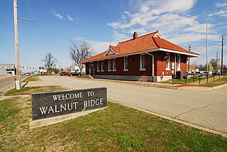
Walnut Ridge is a city in Lawrence County, Arkansas, United States. The population was 5,098 at the United States Census's 2019 estimate. The city is the county seat of Lawrence County. Walnut Ridge lies immediately north of Hoxie. The two towns form a contiguous urban area with approximately 8,000 residents. Williams Baptist University is in College City, a formerly separate community that merged into Walnut Ridge in 2017.

Milton is a home rule-class city along the south bank of the Ohio River in Trimble County, Kentucky, United States. The population was 597 at the time of the 2020 Census, making it the largest city in Trimble County. The Milton-Madison Bridge connects it to Madison, Indiana, and is the only road link between the two states for 40 miles (64 km) in either direction.

Barnesville is a town in Montgomery County, Maryland, United States. It was incorporated in 1888. The population was 144 at the 2020 census.

Damascus is a census-designated place and an unincorporated area in Montgomery County, Maryland, United States. In the early 20th century, there existed an incorporated municipality lasting a quarter century. It had a population of 17,224 as of the 2020 census. Damascus is located at the intersection of two major roads in upper Montgomery County: Ridge Road and Damascus Road.

Old Fort is a town in McDowell County, North Carolina, United States. The population was 811 people in the 2020 U.S. census.

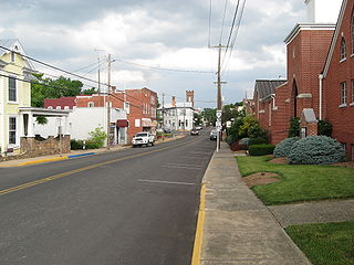
Floyd is a town in Floyd County, Virginia, United States. The population was 448 at the 2020 census. It is the county seat of Floyd County. The Town of Floyd was originally named Jacksonville as the surrounding county was formed during the tenure of President Andrew Jackson. The name was subsequently changed to Floyd for Virginia governor John Floyd.

Boydton is a town in Mecklenburg County, Virginia, United States. The population was 431 at the 2010 census. It is the county seat of Mecklenburg County, and it is near Kerr Lake.
Dayton is a town in Rockingham County, Virginia, United States. The population is 1,530 as of the 2010 census. It is included in the Harrisonburg, Virginia Metropolitan Statistical Area.
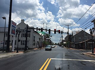
New Market is a town in Shenandoah County, Virginia, United States. Founded as a small crossroads trading town in the Shenandoah Valley, it has a population of 2,146 as of the most recent 2010 U.S. census. The north–south U.S. 11 and the east–west U.S. 211 pass near it and cross Massanutten Mountain at the town's titular gap.

Marion is a town in, and the county seat of, Smyth County, Virginia, United States. It is positioned upon Interstate 81, in the Blue Ridge portion of the Southern Appalachian mountains in Southwest Virginia. The town is named for American Revolutionary War officer Francis Marion. The town limits had a population of approximately 6,000, per 2020 Census estimates. However, together with the neighborhoods, an additional 9,000 residents residing in unincorporated Smyth County have Marion mailing addresses, granting the Marion, VA ZIP code (24354) a total population of about 14,500, which is around half of the county's total population.

Gordonsville is a town in Orange County in the Commonwealth of Virginia in the United States. Located about 19 miles northeast of Charlottesville and 65 miles northwest of Richmond, the population was 1,496 at the 2010 census.

Big Meadows is a recreational area of the Shenandoah National Park in Madison County and Page County, in the US state of Virginia. The meadow is located on the Skyline Drive at Milepost 51 and contains the park's Harry F. Byrd Visitor Center, a lodge, camp store, and camping area. Several hiking trails can be accessed from Big Meadows, including the Mill Prong Trail which leads to Rapidan Camp on the Rapidan River, the fishing retreat of President Herbert Hoover from 1929–1933, which is now restored to its 1930s configuration.

Breaks Interstate Park is a bi-state state park located partly in southeastern Kentucky and mostly in southwestern Virginia, in the Jefferson National Forest, at the northeastern terminus of Pine Mountain. Rather than their respective state park systems, it is instead administered by an interstate compact between the states of Virginia and Kentucky. It is one of several interstate parks in the United States, but only one of two operated jointly under a compact rather than as two separate state park units. The Virginia Department of Conservation and Recreation and the Kentucky Department of Parks are still major partner organizations.

St. Mary is an unincorporated community on the western border of the Blackfeet Indian Reservation adjacent to Glacier National Park in Glacier County, Montana, United States. The village is the eastern terminus of the Going-to-the-Sun Road which bisects the park east to west, a distance of 53 mi (85 km).
Falcon Lake is an unincorporated urban centre at the western end of Falcon Lake situated in the southeasternmost section of the Whiteshell Provincial Park in the Canadian province of Manitoba. It is the major entry point to the Whiteshell from the Trans-Canada Highway. Three provincially operated campgrounds, Falcon Creek, Falcon Beach and Falcon Lakeshore, picnic areas, a swimming beach and adjacent public boat launch, several cottage lot divisions and numerous tourist services make the community a favored entrance point to the provincial park. In 2003, 40% of park visitors entered the park at the Falcon Lake checkpoint.
Apple Grove is a census-designated place (CDP) in Mason County, West Virginia, United States, on the Ohio River located along West Virginia Route 2. Apple Grove lies just south of Gallipolis Ferry. As of the 2010 census, its population was 204. It is part of the Point Pleasant, WV–OH Micropolitan Statistical Area.
Madison Mills is an unincorporated community located in Madison County, Virginia, United States. It is located at the intersection of U.S. Route 15 and Virginia State Route 230.
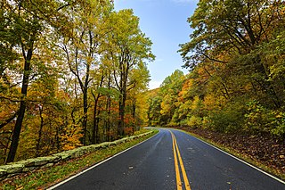
Shenandoah National Park is an American national park that encompasses part of the Blue Ridge Mountains in the Commonwealth of Virginia. The park is long and narrow, with the Shenandoah River and its broad valley to the west, and the rolling hills of the Virginia Piedmont to the east. Skyline Drive is the main park road, generally traversing along the ridgeline of the mountains. Almost 40% of the park's land—79,579 acres —has been designated as wilderness areas and is protected as part of the National Wilderness Preservation System. The highest peak is Hawksbill Mountain at 4,051 feet (1,235 m).
Lorentz is an unincorporated community in Upshur County, West Virginia, United States. Lorentz is located on U.S. routes 33 and 119, 4 miles (6.4 km) west-northwest of Buckhannon. Lorentz has a post office with ZIP code 26229.


