
Sclerophyll is a type of vegetation that is adapted to long periods of dryness and heat. The plants feature hard leaves, short internodes and leaf orientation which is parallel or oblique to direct sunlight. The word comes from the Greek sklēros (hard) and phyllon (leaf). The term was coined by A.F.W. Schimper in 1898, originally as a synonym of xeromorph, but the two words were later differentiated.
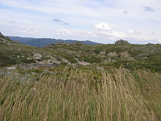
The Australian Alps montane grasslands is a montane grassland ecoregion of south-eastern Australia, restricted to the montane regions above 1300 metres .

Temperate rainforests are rainforests with coniferous or broadleaf forests that occur in the temperate zone and receive heavy rain.
The Tasmanian temperate rain forests are a temperate broadleaf and mixed forests ecoregion in western Tasmania. The ecoregion is part of the Australasian realm, which includes Tasmania and Australia, New Zealand, New Guinea, New Caledonia, and adjacent islands.

The ecology of California can be understood by dividing the state into a number of ecoregions, which contain distinct ecological communities of plants and animals in a contiguous region. The ecoregions of California can be grouped into four major groups: desert ecoregions, Mediterranean ecoregions, forested mountains, and coastal forests.

The Madagascar subhumid forests are a tropical moist broadleaf forest ecoregion that covers most of the Central Highlands of the island of Madagascar. They are included in the WWF's Global 200 list of outstanding ecoregions. Most of the original habitats have been lost due to human pressure.

Tasmania, the largest island of Australia, has a landmass of 68,401 km2 (26,410 sq mi) and is located directly in the pathway of the notorious "Roaring Forties" wind that encircles the globe. To its north, it is separated from mainland Australia by Bass Strait. Tasmania is the only Australian state that is not located on the Australian mainland. About 2,500 kilometres south of Tasmania island lies the George V Coast of Antarctica. Depending on which borders of the oceans are used, the island can be said to be either surrounded by the Southern Ocean, or to have the Pacific on its east and the Indian to its west. Still other definitions of the ocean boundaries would have Tasmania with the Great Australian Bight to the west, and the Tasman Sea to the east. The southernmost point on mainland Tasmania is approximately 43°38′37″S146°49′38″E at South East Cape, and the northernmost point on mainland Tasmania is approximately 40°38′26″S144°43′33″E in Woolnorth / Temdudheker near Cape Grim / Kennaook. Tasmania lies at similar latitudes to Te Waipounamu / South Island of New Zealand, and parts of Patagonia in South America, and relative to the Northern Hemisphere, it lies at similar latitudes to Hokkaido in Japan, Northeast China (Manchuria), the north Mediterranean in Europe, and the Canada-United States border.

The New Caledonia rain forests are a terrestrial ecoregion, located in New Caledonia in the South Pacific. It is a tropical moist broadleaf forest ecoregion, part of the Australasian realm.

Nothofagus gunnii, the tanglefoot or deciduous beech, is a deciduous shrub or small tree endemic to the highlands of Tasmania, Australia. It was described in 1847 by R.C Gunn N. gunnii is a small woody tree with a shrubby appearance known to grow up to 8 metres (26 ft). It lives only on mountains due to temperature limitations within the Tasmanian maritime climate and mainly grows at altitudes greater than 800 metres (2,600 ft) above sea level. It grows in alpine and sub-alpine regions in the central portions of the island. Though capable of reaching the size of a small tree, it is most common as a thick shrub or woody ground cover, hence its common name of "tanglefoot".

Athrotaxis cupressoides, commonly known as pencil pine, despite being a species of the family Cupressaceae and not a member of the pine family. Found either as an erect shrub or as a tree, this species is endemic to Tasmania, Australia. Trees can live for upwards of 1000 years, sustaining a very slow growth rate of approximately 12 mm in diameter per year.

The Eastern Himalayan alpine shrub and meadows is a montane grasslands and shrublands ecoregion of Bhutan, China, India, Myanmar, and Nepal, which lies between the tree line and snow line in the eastern portion of the Himalaya Range.

The Central Range montane rain forests is a tropical moist forest ecoregion on the island of New Guinea. The ecoregion covers the Central Range of the New Guinea Highlands, which extends along the spine of the island. The montane rain forests of the ecoregion are distinct from the surrounding lowland forests, and are home to many endemic plants and animals.

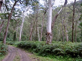
The Eastern Australian temperate forests is a broad ecoregion of open forest on uplands starting from the east coast of New South Wales in the South Coast to southern Queensland, Australia. Although dry sclerophyll and wet sclerophyll eucalyptus forests predominate within this ecoregion, a number of distinguishable rainforest communities are present as well.

The Southland montane grasslands, also known as the South Island montane grasslands, is a montane grasslands and shrublands ecoregion on New Zealand’s South Island. The ecoregion covers the middle portion of the Southern Alps, and includes extensive alpine grasslands, fellfields, and montane forests.
Alpine vegetation refers to the zone of vegetation between the altitudinal limit for tree growth and the nival zone. Alpine zones in Tasmania can be difficult to classify owing to Tasmania's maritime climate limiting snow lie to short periods and the presence of a tree line that is not clearly defined.
Tasmania can be broadly divided into two distinct regions, eastern and western, that exhibit major differences in climate, geology and vegetation. This divide, termed Tyler’s Corridor, runs from just south of the northwestern corner, and continues south, cutting roughly down the center of the island. The vegetation changes occur principally due to variations in soil types, which are a result of the geological composition, and the vast difference in climate across the state. Generally, the west has a higher mean rainfall but poor acidic soil while the east has a lower mean rainfall but slightly more fertile soil. This results in a larger proportion of rainforest, moorland and wet sclerophyll vegetation dominating in the west and predominantly dry sclerophyll in the east.

Trochocarpa cunninghamii is a flowering plant species of the family Ericaceae. It is commonly referred to as straggling purpleberry due to its round flattened mauve drupe fruits. This woody shrub is usually found in the understorey of rainforests and subalpine forests in the Central Plateau and western Tasmania, and is endemic to Tasmania.
The Southeast Australia temperate forests is a temperate broadleaf and mixed forests ecoregion of south-eastern Australia. It includes the temperate lowland forests of southeastern Australia, at the southern end of the Great Dividing Range. Vegetation ranges from wet forests along the coast to dry forests and woodlands inland.
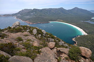
The Tasmanian temperate forests is a temperate broadleaf and mixed forests ecoregion in Australia. The ecoregion occupies the eastern portion of the island of Tasmania, which lies south of the Australian mainland.

Rainforests and vine thickets are a major vegetation group in Australia. It consists of temperate to tropical rainforests, monsoon forests, and vine thickets. Rainforests and vine thickets are generally found in small pockets across the eastern and northern portions of the continent, including western Tasmania, eastern New South Wales, eastern Queensland, the northern portion of the Northern Territory, and the Kimberley Region of northeastern Western Australia.

