Tasmanian temperate forests

Last updated
Tasmanian temperate forests
20100209 Wineglass Bay and The Hazards from Mt Amos peak.JPG
Wineglass Bay, Freycinet National Park
Ecoregion AA0412.png
Ecoregion territory (in purple)
Ecology
Realm Australasian
Biome temperate broadleaf and mixed forests
Borders
Geography
Area18,252 km2 (7,047 sq mi)
Country Australia
State Tasmania
Coordinates 41°12′S147°42′E / 41.2°S 147.7°E / -41.2; 147.7
Conservation
Conservation status Critical/endangered [1]
Protected4,056 km2 (22.22%) [2]

The Tasmanian temperate forests is a temperate broadleaf and mixed forests ecoregion in Australia. The ecoregion occupies the eastern portion of the island of Tasmania, which lies south of the Australian mainland. [3] [4]

Contents

Geography

The ecoregion occupies the eastern portion of Tasmania, as well as islands in the Bass Strait separating Tasmania from Australia – the Furneaux Group of islands off Tasmania's northeast coast, and King Island northwest of Tasmania.

Climate

The ecoregion has a temperate climate. It is located on the drier eastern side of Tasmania, and average annual rainfall varies from 400 to 1,000 mm (16 to 39 in). Rainfall is variable from year to year and month to month, with no pronounced seasonal minimum. Rain generally falls in light showers, with the heaviest rainfall during the spring or autumn. [1]

Flora

Plant communities in the ecoregion include dry sclerophyll eucalypt forest, wet sclerophyll eucalypt forest, Allocasuarina-Callitris woodland, rainforest, grassland, and heath. Fire shaped the plant communities in eastern Tasmania. For thousands of years, the Aboriginal Tasmanians deliberately set regular fires, which transformed much of the landscape into open savanna and woodland of fire-adapted plants dominated by species of Eucalyptus . Settlers from Europe started arriving in the 18th century, and mostly displaced the Aboriginal Tasmanians. These settlers ceased the regular burning of the landscape, and many of the open savannas and woodlands grew into shrubby forests. European settlers also altered the landscape by grazing livestock, logging forests for timber, and establishing forestry plantations of exotic trees. [1]

The dry eucalypt forests have an open canopy. Peppermint eucalypts, including Eucalyptus amygdalina, Eucalyptus pulchella , and Eucalyptus viminalis , are the predominant trees, growing more than 5 meters in height. There is an understorey of xerophytic shrubs and small trees, including species of Acacia, Allocasuarina , and Exocarpos . [1]

Wet eucalypt forest is found on the higher slopes of Ben Lomond and the wetter areas of King Island. Eucalyptus globulus, Eucalyptus brookeriana , and Eucalyptus regnans are the predominant trees. There are also patches of rainforest in areas sheltered from fire, and alpine vegetation on mountain peaks. [1]

Low, dry Allocasuarina-Callitris woodlands are found on the Furneaux Group and along the east coast of Tasmania. These woodlands are sensitive to fire disturbance. Allocasuarina verticillata is predominant, sometimes forming monospecific stands, and sometimes forming woodlands with Callitris or with Eucalyptus viminalis and E. globulus. Callitris oblonga is low shrubby tree found in Tasmania's dry woodlands. Callitris rhomboidea grows in fire-protected sites on Tasmania and the Furneaux Group, where it can grow up to 30 metres high. [1]

Prior to European settlement, Bass Strait islands were mostly covered with dry sclerophyll woodland, wet and dry forests, and heath. Wet sclerophyll forests with some rainforest species were found in wetter areas of King Island, but these forests have mostly been destroyed. Allocasuarina-Callitris woodlands occurred in drier areas of the Furneaux Group. Many of the smaller islands are now covered in tussock grasslands of Poa poiformis. [1]

Fauna

Tasmania and the Bass Strait islands were connected to Australia during the ice ages when sea levels were lower, and shared a marsupial mammal fauna. The largest carnivores were the thylacine (Thylacinus cynocephalus), which was hunted to extinction by the early 20th century, and the Tasmanian devil (Sarcophilus harrisii). Both the thylacine and the Tasmanian devil were once widespread on mainland Australia, but went extinct there prior to European colonization. The dingo (Canis lupus dingo), brought to Australia by Aboriginals, and may have out-competed the marsupial predators there, but dingoes were never introduced to Tasmania. [1]

Larger herbivores include the red-necked wallaby (Macropus rufogriseus), eastern grey kangaroo (Macropus giganteus), the Tasmanian subspecies of common wombat (Vombatus ursinus tasmaniensis), and the Flinders Island wombat (V. u. ursinus). The short-beaked echidna (Tachyglossus aculeatus) prefers sclerophyll forests and heaths. The platypus (Ornithorhynchus anatimus) lives in freshwater habitats across Tasmania and on King Island. Other mammals include the long-nosed potoroo (Potorous tridactylus), Tasmanian bettong (Bettongia gaimardi), Tasmanian pygmy possum (Cercartetus lepidus), eastern barred bandicoot (Perameles gunnii), tiger quoll (Dasyurus maculatus), and eastern quoll (D. viverrinus). [1]

Many native birds are limited to Tasmania and the Bass Strait islands, including the forty-spotted pardalote (Pardalotus quadragintus), Tasmanian native hen (Gallinula mortierii), black-headed honeyeater (Melithreptus affinis), yellow wattlebird (Anthochaera paradoxa), green rosella (Platycercus caledonicus), Tasmanian scrubwren (Sericornis humilis), and yellow-throated honeyeater (Nesoptilotis flavicollis). The swift parrot (Lathamus discolor) breeds in Tasmania and ranges into southeastern Australia. The two native subspecies of emu, Tasmanian emu (Dromaius novaehollandiae diemenensis) and King Island emu (Dromaius novaehollandiae minor), were hunted to extinction. [1]

There are about ten native species of lizards, including the mountain dragon (Rankinia diemensis) and the endemic Rawlinson's window-eyed skink (Pseudemoia rawlinsoni). The two endemic amphibians are the Tasmanian tree frog (Litoria burrowsi) and Tasmanian froglet (Crinia tasmaniensis).

Protected areas

Protected areas include Ben Lomond National Park (181.9 km2), Mount William National Park (184.39 km2), Douglas-Apsley National Park (160.8 km2), Freycinet National Park (169 km2), Maria Island National Park (115 km2), Lavinia State Reserve (78.8 km2), Lime Bay State Reserve (15.1 km2), Logan Lagoon Conservation Area (48.7 km2), Mount Barrow State Reserve (15.8 km2), St. Patricks Head State Reserve (13.2 km2), and Moulting Lagoon Game Reserve (48 km2). Moulting Lagoon (45.2 km2) and Logan Lagoon (22.6 km2) are also Ramsar wetlands of international importance. [2]

Related Research Articles

<span class="mw-page-title-main">Sclerophyll</span> Type of plant

Sclerophyll is a type of vegetation that is adapted to long periods of dryness and heat. The plants feature hard leaves, short internodes and leaf orientation which is parallel or oblique to direct sunlight. The word comes from the Greek sklēros (hard) and phyllon (leaf). The term was coined by A.F.W. Schimper in 1898, originally as a synonym of xeromorph, but the two words were later differentiated.

<span class="mw-page-title-main">Geography of Tasmania</span>

Tasmania, the largest island of Australia, has a landmass of 68,401 km2 (26,410 sq mi) and is located directly in the pathway of the notorious "Roaring Forties" wind that encircles the globe. To its north, it is separated from mainland Australia by Bass Strait. Tasmania is the only Australian state that is not located on the Australian mainland. About 2,500 kilometres south of Tasmania island lies the George V Coast of Antarctica. Depending on which borders of the oceans are used, the island can be said to be either surrounded by the Southern Ocean, or to have the Pacific on its east and the Indian to its west. Still other definitions of the ocean boundaries would have Tasmania with the Great Australian Bight to the west, and the Tasman Sea to the east. The southernmost point on mainland Tasmania is approximately 43°38′37″S146°49′38″E at South East Cape, and the northernmost point on mainland Tasmania is approximately 40°38′26″S144°43′33″E in Woolnorth / Temdudheker near Cape Grim / Kennaook. Tasmania lies at similar latitudes to Te Waipounamu / South Island of New Zealand, and parts of Patagonia in South America, and relative to the Northern Hemisphere, it lies at similar latitudes to Hokkaido in Japan, Northeast China (Manchuria), the north Mediterranean in Europe, and the Canada-United States border.

The western false pipistrelle, species Falsistrellus mackenziei, is a vespertilionid bat that occurs in Southwest Australia. The population is declining due to loss of its habitat, old growth in tall eucalypt forest which has largely been clear felled for tree plantations, wheat cultivation and urbanisation. Although it is one of the largest Australian bats of the family, the species was not recorded or described until the early 1960s. A darkly colored bat with reddish brown fur and prominent ears, they fly rapidly around the upper canopy of trees in pursuit of flying insects.

<span class="mw-page-title-main">Eastern Australian temperate forests</span> Ecoregion in Australia

The Eastern Australian temperate forests is a broad ecoregion of open forest on uplands starting from the east coast of New South Wales in the South Coast to southern Queensland, Australia. Although dry sclerophyll and wet sclerophyll eucalyptus forests predominate within this ecoregion, a number of distinguishable rainforest communities are present as well.

<span class="mw-page-title-main">Mount Lofty woodlands</span> Ecoregion in South Australia

The Mount Lofty woodlands, or the Peppermint Box Grassy Woodland of South Australia, is an ecoregion in South Australia, which includes woodlands, shrublands, and grasslands in the Mount Lofty Ranges, Fleurieu Peninsula, and Kangaroo Island.

<span class="mw-page-title-main">Ecology of Tasmania</span>

The biodiversity of Tasmania is of exceptional biological and paleoecological interest. A state of Australia, it is a large South Pacific archipelago of one large main island and a range of smaller islands. The terrain includes a variety of reefs, atolls, many small islands, and a variety of topographical and edaphic regions on the largest island, all of which promote the development of unusually concentrated biodiversity. During long periods geographically and genetically isolated, it is known for its unique flora and fauna. The region's climate is oceanic.

<span class="mw-page-title-main">North-west Tasmanian Coast Important Bird Area</span> Important bird area in Tasmania, Australia

The North-west Tasmanian Coast Important Bird Area comprises a 2438 km2 stretch of coastal and subcoastal land covering the northern section of the coast of western Tasmania, south-eastern Australia.

<span class="mw-page-title-main">Tasmanian dry sclerophyll forests</span>

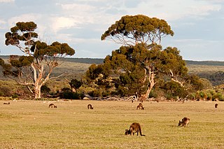
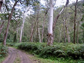
Dry sclerophyll forests occur throughout northern and eastern Tasmania. Characterised by the population of hard-leafed (sclerophyll) and often spiky, drought-adapted plants, dry sclerophyll forests are found in regions of where annual rainfall is below 1000mm.

<i>Eucalyptus pulchella</i> Species of eucalyptus

Eucalyptus pulchella, commonly known as the white peppermint or narrow-leaved peppermint, is a species of small to medium-sized tree that is endemic to Tasmania. it has smooth bark, sometimes with rough fibrous bark on older trees, linear leaves, flower buds in groups of nine to twenty or more, white flowers and cup-shaped to shortened spherical fruit.

Tasmania can be broadly divided into two distinct regions, eastern and western, that exhibit major differences in climate, geology and vegetation. This divide, termed Tyler’s Corridor, runs from just south of the northwestern corner, and continues south, cutting roughly down the center of the island. The vegetation changes occur principally due to variations in soil types, which are a result of the geological composition, and the vast difference in climate across the state. Generally, the west has a higher mean rainfall but poor acidic soil while the east has a lower mean rainfall but slightly more fertile soil. This results in a larger proportion of rainforest, moorland and wet sclerophyll vegetation dominating in the west and predominantly dry sclerophyll in the east.

<span class="mw-page-title-main">Cumberland Plain Woodland</span> Indigenous woodland community in Sydney, Australia

The Cumberland Plain Woodland, also known as Cumberland Plain Bushland and Western Sydney woodland, is a grassy woodland community found predominantly in Western Sydney, New South Wales, Australia, that comprises an open tree canopy, a groundcover with grasses and herbs, usually with layers of shrubs and/or small trees.

<span class="mw-page-title-main">Ecology of Sydney</span> Geographic aspect of Sydney, Australia

The ecology of Sydney, located in the state of New South Wales, Australia, is diverse for its size, where it would mainly feature biomes such as grassy woodlands or savannas and some sclerophyll forests, with some pockets of mallee shrublands, riparian forests, heathlands, and wetlands, in addition to small temperate rainforest fragments.

<span class="mw-page-title-main">Southeast Australia temperate forests</span> Terrestrial ecoregion in Australia

The Southeast Australia temperate forests is a temperate broadleaf and mixed forests ecoregion of south-eastern Australia. It includes the temperate lowland forests of southeastern Australia, at the southern end of the Great Dividing Range. Vegetation ranges from wet forests along the coast to dry forests and woodlands inland.

<span class="mw-page-title-main">Tasmanian Central Highland forests</span> Terrestrial ecoregion in Tasmania, Australia

The Tasmanian Central Highland forests is a temperate broadleaf and mixed forests ecoregion in Australia. It covers Tasmania's Central Highlands region.

<i>Bedfordia salicina</i> Species of flowering plant

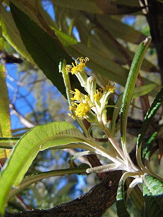
Bedfordia salicina, commonly known as Tasmanian blanketleaf, is an endemic angiosperm of Tasmania, Australia. It is widespread throughout wet sclerophyll forests, moist gullies and intermediate forests and woodlands between wet and dry sclerophyll communities. Bedfordia salicina is abundant at low elevations, on dolerite, sandstone and mudstone substrate, east of Tylers line. Alternating leaves droop down to blanket the stem, coining the species common name, blanketleaf.

<span class="mw-page-title-main">Gippsland Plains Grassy Woodland</span> Ecological community in southern Victoria

The Gippsland Plains Grassy Woodland is an ecological temperate grassland community located in the Gippsland region in southern Victoria, Australia. Stretching from Bairnsdale in the east to the eastern portion of Melbourne in the west, they typify one of Victoria's most threatened and disconnected indigenous ecosystems. The Gippsland Red Gum Grassy Woodland is the most prominent community in the system situated in the centre.

<span class="mw-page-title-main">Blue Mountains and Southern Highlands Basalt Forests</span> Ecological community in New South Wales

The Blue Mountains and Southern Highlands Basalt Forests are a sclerophyll temperate forest community that stretch from the northern fringes of the Blue Mountains to the Southern Highlands in New South Wales, Australia. Featuring both wet and dry sclerophyll forests, as well as small rainforest pockets, the community features tall (30m+) and open eucalypt forests and woodlands that lie on igneous rock.

<span class="mw-page-title-main">Rainforests and vine thickets</span>

Rainforests and vine thickets are a major vegetation group in Australia. It consists of temperate to tropical rainforests, monsoon forests, and vine thickets. Rainforests and vine thickets are generally found in small pockets across the eastern and northern portions of the continent, including western Tasmania, eastern New South Wales, eastern Queensland, the northern portion of the Northern Territory, and the Kimberley Region of northeastern Western Australia.

References

  1. 1 2 3 4 5 6 7 8 9 10 "Tasmanian temperate forests". Terrestrial Ecoregions. World Wildlife Fund.
  2. 1 2 "Tasmanian temperate forests". Digital Observatory for Protected Areas Explorer 4. Accessed 25 October 2020.
  3. "Map of Ecoregions 2017". Resolve. Retrieved August 20, 2021.
  4. "Tasmanian temperate forests". The Encyclopedia of Earth. Retrieved August 20, 2021.

Commons-logo.svg Media related to Tasmanian temperate forests at Wikimedia Commons