Mountain City is a town in, and the county seat of Johnson County, Tennessee, United States. The population was 2,383 at the 2000 census and 2,531 at the 2010 census. It is the northeasternmost county seat in Tennessee. In addition, at an elevation of 2,418 feet (737 m), it has the distinction of being the highest incorporated city in the state.

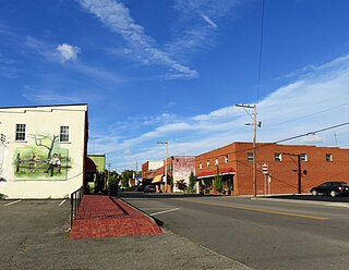
Abingdon is a town in Washington County, Virginia, United States, 133 miles (214 km) southwest of Roanoke. The population was 8,376 at the 2020 census. It is the county seat of Washington County. The town encompasses several historically significant sites and features a fine arts and crafts scene centered on the galleries and museums along Main Street.

Damascus is a town in Washington County, Virginia, United States. The population was 814 at the 2010 census. It is part of the Kingsport–Bristol (TN)–Bristol (VA) Metropolitan Statistical Area, which is a component of the Johnson City–Kingsport–Bristol, TN-VA Combined Statistical Area.
The Iron Mountains are a subrange of the Blue Ridge Mountains. These mountains are located around the common meeting point of Tennessee, Virginia, and North Carolina.
U.S. Route 58 is an east–west U.S. Highway that runs for 508 miles (818 km) from U.S. Route 25E just northwest of Harrogate, Tennessee, to U.S. Route 60 in Virginia Beach, Virginia. Until 1996, when the Cumberland Gap Tunnel opened, US 58 ran only inside the commonwealth of Virginia. It was then extended southwest along a short piece of former US 25E, which no longer enters Virginia, to end at the new alignment in Tennessee. For most of its alignment, it closely parallels Virginia's southern border with North Carolina.
Food City is an American supermarket chain with stores located in Alabama, Georgia, Kentucky, Tennessee, and Virginia. It is owned by K-VA-T Food Stores, Inc., a privately held family and employee-owned corporation headquartered in Abingdon, Virginia. K-VA-T Food Stores owns the Food City Distribution Center, a distribution center K-VA-T helped form in 1974 and acquired full control of in 1998, Misty Mountain Spring Water, LLC, a producer of bottled water, as well as limited-assortment grocery stores named Super Dollar Food Center, Food City Express and Gas'N Go convenience stores, and Food City Wine and Spirits liquor stores. Many of their grocery stores have their own fuel stations, with the Gas'N Go branding.

The Tygart Valley River — also known as the Tygart River — is a principal tributary of the Monongahela River, approximately 135 miles (217 km) long, in east-central West Virginia in the United States. Via the Monongahela and Ohio rivers, it is part of the watershed of the Mississippi River, draining an area of 1,329 square miles (3,440 km2) in the Allegheny Mountains and the unglaciated portion of the Allegheny Plateau.

The Virginia Creeper Trail is a 35-mile (56 km) multi-purpose rail trail. Located in southwestern Virginia, the trail runs from Abingdon to Whitetop, Virginia, near Mount Rogers National Recreation Area and the North Carolina state line.

Breaks Interstate Park is a bi-state state park located partly in southeastern Kentucky and mostly in southwestern Virginia, in the Jefferson National Forest, at the northeastern terminus of Pine Mountain. Rather than their respective state park systems, it is instead administered by an interstate compact between the states of Virginia and Kentucky. It is one of several interstate parks in the United States, but only one of two operated jointly under a compact rather than as two separate state park units. The Virginia Department of Conservation and Recreation and the Kentucky Department of Parks are still major partner organizations, however.
The Virginia–Carolina Railway was an interstate railroad in southwestern Virginia and northwestern North Carolina. It ran from Abingdon in Washington County, Virginia to Todd in Ashe County, North Carolina. The line charted a complicated course through the mountains of the area, crossing the Blue Ridge not far from Mount Rogers.
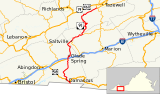
State Route 91 is a primary state highway in the U.S. state of Virginia. The state highway runs 55.12 miles (88.71 km) from the Tennessee state line near Damascus, where the highway continues as Tennessee State Route 91, north to U.S. Route 19 Business and US 460 Business at Frog Level. SR 91 connects Damascus in southeastern Washington County with the northeastern county town Glade Spring, where the highway has junctions with US 11 and Interstate 81 (I-81). The state highway also indirectly connects Saltville in northwestern Smyth County and Tazewell, the county seat of Tazewell County. SR 91 is the only primary state highway in Virginia with an unpaved section; this gravel section is in southern Tazewell County.
The Appalachian National Scenic Trail spans fourteen U.S. states during its roughly 2,200 miles (3,500 km)-long journey: Georgia, North Carolina, Tennessee, Virginia, West Virginia, Maryland, Pennsylvania, New Jersey, New York, Connecticut, Massachusetts, Vermont, New Hampshire, and Maine. The southern end is at Springer Mountain, Georgia, and it follows the ridgeline of the Appalachian Mountains, crossing many of its highest peaks and running almost continuously through wilderness before reaching the northern end at Mount Katahdin, Maine.
Interstate 81 (I-81) is an 855.02-mile-long (1,376.02 km) Interstate Highway. In the US state of Virginia, I-81 runs for 324.92 miles (522.91 km), making the portion in Virginia longer than any other state's portion. It is also the longest Interstate Highway within the borders of Virginia. It stretches from the Tennessee state line near Bristol to the West Virginia state line near Winchester. It enters Virginia from Bristol, Tennessee, and leaves Virginia into Berkeley County, West Virginia.

Hampton is an unincorporated community in Carter County, Tennessee, United States. Located a few miles southeast of Elizabethton and northwest of Roan Mountain, Hampton is surrounded on all sides by the Unaka Mountains. It is part of the Johnson City Metropolitan Statistical Area, which is a component of the Johnson City–Kingsport–Bristol, TN-VA Combined Statistical Area – commonly known as the "Tri-Cities" region.
State Route 70 is a state-maintained highway in East Tennessee, beginning at the border with North Carolina in the midst of the Cherokee National Forest and the Great Smoky Mountains and ending at the Virginia border in the extremely rural and mountainous terrain of Hancock County.
State Route 91 is a state highway in the northeastern portion of the U.S. state of Tennessee, in the area known as the Tri-Cities region. The route connects Johnson City with Damascus, Virginia via Elizabethton, Hunter, and Mountain City.
The Lynn Camp Creek Wilderness Study Area, a 3226-acre site in the Eastern Divide Ranger District of the George Washington and Jefferson National Forests, was designated a wilderness study area by the Omnibus Public Lands Act of 2009.
The North Carolina–Tennessee–Virginia Corners is a tripoint at which North Carolina, Tennessee and Virginia meet. The landmark is located in the Iron Mountains, and is roughly 16 miles north of Snake Mountain, and 8 miles southwest of Mount Rogers.

Whitetop Laurel is a wildland in the George Washington and Jefferson National Forests of western Virginia that has been recognized by the Wilderness Society as a special place worthy of protection from logging and road construction. The Wilderness Society has designated the area as a "Mountain Treasure".


