Tel Beit Shemesh

Last updated
Tel Beit Shemesh from the air Air Tel Beit Shemesh1.jpg
Tel Beit Shemesh from the air
Ain Shems (today known as Tel Beit Shemesh) in the PEF Survey of Palestine c.1880. The pink circles are contemporary villages, and the dotted clear circles are ruins. Ain Shems (today known as Tel Beit Shemesh) in the Survey of Western Palestine 1880.17 (cropped).jpg
Ain Shems (today known as Tel Beit Shemesh) in the PEF Survey of Palestine c.1880. The pink circles are contemporary villages, and the dotted clear circles are ruins.

Tel Beit Shemesh is a small archaeological tell northeast of the modern city of Beit Shemesh.

Contents

It was identified in the late 1830s as Biblical Beth Shemesh – it then was known as Ain Shams – by Edward Robinson. [1] [2] The tel was excavated in numerous phases during the 20th century.

Etymology

Beit Shemesh means "house of the sun" or "temple of the sun" in Hebrew. The Bronze-Age city was originally named after the Canaanite sun-goddess Shapash, sometimes called Shemesh, who was worshipped there in antiquity. [3]

The name Beth-Shemesh was shared by (at least) two other places in Israel, and one more in Egypt, presumably the site known in Greek as Heliopolis, bearing the same meaning. [4]

History

Canaanite and Israelite town

The Canaanites of Beit Shemesh named the city after Shapash/Shemesh, the sun-goddess they worshipped. The ruins of the ancient biblical city of the Canaanites and Israelites are located at a site called Tel Beit Shemesh in Modern Hebrew and Tell er-Rumeileh in Arabic, a tell (archaeological mound) [3] situated immediately west of modern Beit Shemesh, and Moshav Yish'i, right on the west side of Highway 38.

The earliest mention of Beit Shemesh is found in Egyptian execration texts, dating several hundred years earlier than its mention in Hebrew canonical books. [5]

The ancient tell of Bet Shemesh Tel Bet Shemesh 3.JPG
The ancient tell of Bet Shemesh

Hebrew Bible

Beit Shemesh is mentioned in the Hebrew Bible in the Book of Joshua (Joshua 15:10), as a city in the territory of the tribe of Judah on the border with the tribe of Dan. In Joshua 21:16, this city was set aside as one of the 13 Kohanic cities for the priests of the tribe of Levi, the Kohanim.

Another city by the same name, Beit Shemesh, is later mentioned in Joshua 19:38, being situated in the territory of the tribe of Naphtali.

The city located in the territorial bounds of the tribe of Judah is mentioned in the 6th chapter of 1 Samuel as being the first city encountered by the Ark of the Covenant on its way back from Philistia after having been captured by the Philistines in battle (1 Samuel 6:12–21). According to the chapter, the people of Beit Shemesh looked into the Ark, and God struck them dead. The stone on which the Ark was placed is recorded as still being located there at the time of writing the Books of Samuel. In the King James Version this stone is described as "the great stone of Abel" (1 Samuel 6:18).

In 2 Kings 14, Beit Shemesh is again mentioned as being the site of the battle between King Amaziah of Judea and King Jehoash of Israel.

Iron Age to Persian period

During the 10th century BCE, Beit Shemesh emerged as an Israelite governmental center in the Sorek Valley. [6]

An archaeomagnetic study has dated a destruction layer at the site to the first half of the 8th century BCE, correlating with the time when King Jehoash of Israel is recorded as having defeated King Amaziah of Judah in a battle fought there (2 Kings 14:11–13). [7]

After the destruction of much of Judah by Sennacherib in 701 BCE, the city was abandoned for a while, but there seems to have been an attempt by a group of Judahites at resettling Beth Shemesh, judging by the refurbishing of the water reservoir in the 7th century BCE. [8] However, after the Babylonian conquest of Judah in the early 580s, either the new Babylonian rulers, or the nearby Philistine metropolis of Ekron favoured by them, apparently put an end to the initiative by sealing and covering over the vital water reservoir, [8] which was not uncovered until 2004. During the first Jewish return, at the beginning of the Second Temple period, there was no lasting revival of the city, as opposed to many other places in the vicinity such as Beit Guvrin,[ dubious ] Maresha, and others.[ citation needed ][ dubious ]

In the rescue excavations at the site, a rectangular gas-fired structure was discovered which was identified by the excavators as a synagogue from the Second Temple period. [9] The synagogue is supposed to be moved to another location to clear the area for road 38, which is planned to be paved in the area. Boaz Gross, the head of the excavation expedition at the Tel on behalf of the Israel Institute of Archaeology, believed that the structure is not Hasmonean but probably from the Herodian period. The village around him, he believes, was abandoned during the Bar Kokhba revolt. According to him, purification bowls found near the building, its architectural design, as well as a bench identified inside, strengthen the assumption that it is a synagogue. [10]

Byzantine period

A monastery and other remains from the Byzantine period have been found in the area. [11]

Ancient ruins against backdrop of modern Beit Shemesh PikiWiki Israel 9766 old bet shemesh.jpg
Ancient ruins against backdrop of modern Beit Shemesh

Ottoman period

'Ain Shems, the site of Beth-Shemesh. South of the Wady es Sur'ar (Sorek) and nearly opposite to Sur'ah (Zorah). The ancient and modern names Beth-Shemesh (House of the Sun) and 'Ain Shems (NYPL b10607452-80663) (cropped) 'Ain Shems, the site of Beth-Shemesh. South of the Wady es Sur'ar (Sorek) and nearly opposite to Sur'ah (Zorah). The ancient and modern names Beth-Shemesh (House of the Sun) and 'Ain Shems (NYPL b10607452-80663) (cropped).jpg
'Ain Shems, the site of Beth-Shemesh. South of the Wâdy es Sur'ar (Sorek) and nearly opposite to Sur'ah (Zorah). The ancient and modern names Beth-Shemesh (House of the Sun) and 'Ain Shems (NYPL b10607452-80663) (cropped)

The small Arab towns of Dayr Aban and Dayr Rafat used rocks for building from Tell er-Rumeileh (Tel Beit Shemesh).[ citation needed ]

In the late 19th century the area was known as 'Ain Shems or Khirbet 'Ain Shems and was used as a temporary harvest-time residence by local Arabs. [12] [13] The small mosque of Abu Mizar stood there. [13]

State of Israel

During the 1948 Arab–Israeli War, the Egyptian Army invaded the area and set up a fortified post, called "Mishlat" in Hebrew, on a hill overlooking Beit Shemesh, within the Arab village Dayr Aban. The post changed hands several times during fighting. The Harel Brigade occupied part of the post for several months, giving rise to the name "the joint post" or the "Mishlat HaMeshutaf", with 60 meters dividing them and the enemy forces. The Mishlat was finally taken by the Harel force in the Ha-Har offensive, during the night of 19–20 October 1948.[ citation needed ]

Beit Shemesh is the point from which the so-called Convoy of 35 set out to bring provisions to besieged Gush Etzion. On 15 January 1948, a group of 38 Palmach volunteers left Hartuv near Beit Shemesh. After one member of the group sprained his ankle and returned, accompanied by two others, the group, now numbering 35, continued on its way. Their presence was discovered by two Arab women who encountered two scouts of the group near Surif. (An earlier version, that the soldiers were discovered by an Arab shepherd who they graciously let go, was based on a eulogy written by Ben-Gurion and is apparently apocryphal). [14] The Convoy of 35 was subsequently killed in fighting with Arab villagers and militiamen.

Archaeology

Old wall of the ancient ruin, Beit Shemesh Beit Shemesh - New and Old.jpg
Old wall of the ancient ruin, Beit Shemesh
Middle Bronze gate system unearthed at Tel Beth-Shemesh Mb gate tbs.png
Middle Bronze gate system unearthed at Tel Beth-Shemesh

From 1911 to 1913 the site was excavated by a Palestine Exploration Fund team led by Duncan Mackenzie. [15] [16]

The site was excavated from 1928 to 1933 by a Haverford College, Pennsylvania team led by Elihu Grant. [17] [18] [19] [20] [21] [22] A fractured Late Bronze Age cuneiform tablet was found. [23]

Work resumed from 1990 to 1996 led by Shlomo Bunimovitz and Zvi Lederman under the auspices of the Department of the Land of Israel Studies at Bar-Ilan University and the Department of Bible and Ancient Near Eastern Studies at Ben-Gurion University of the Negev. [24] [25] [26]

Late Bronze and Iron Age

The most ancient iron workshop in the world was discovered in Beit Shemesh in 2003. The only remnants of a fortified city with an advanced water system, from the time of the early Kingdom of Judah was found here. The bones of animals found in the 12th–11th centuries BCE layer indicate a diet typical of the Israelites who inhabited the hill country in this period. These together with the pottery finds indicate the cultural influences on the inhabitants of this border town. However, it is not possible to determine their specific ethnic identity, which could be Canaanite, Philistine, or Israelite. [3]

In August 2012, archaeologists from Tel Aviv University announced the discovery of a circular stone seal, approximately 15 millimetres in diameter. The seal was found on the floor of a house at Beit Shemesh and is dated to the 12th century BCE. According to Haaretz, "excavation directors Prof. Shlomo Bunimovitz and Dr. Zvi Lederman of Tel Aviv University say they do not suggest that the human figure on the seal is the biblical Samson. Rather, the geographical proximity to the area where Samson lived, and the time period of the seal, show that a story was being told at the time of a hero who fought a lion, and that the story eventually found its way into the biblical text and onto the seal." [27]

Animal bones found nearby may also be a clue to boundary disputes between different cultures. Pig bones have been found a few kilometers from Beit Shemesh, but only a few have been found actually at Beit Shemesh and at some point during the 11th century BCE it appears that the local population stopped eating pig. Haaretz reports that "According to Bunimovitz, when the pork-eating Philistines arrived in the country from the Aegean, the local people stopped eating pork to differentiate themselves from the newcomers." [27]

Tel Beit Shemesh on the left, and on the right the large salvage excavation that revealed the eastern part of the mound tl byt SHmSH vhKHpyrvt.jpg
Tel Beit Shemesh on the left, and on the right the large salvage excavation that revealed the eastern part of the mound

As part of the works to expand a nearby road, Route 38, many archaeological finds were uncovered in Tel Beit Shemesh, the Beit Shemesh Municipality promoted the transformation of the complex into a visitor center and park with an investment of tens of millions of shekels. [28] National Roads Company of Israel agreed to significantly reduce the width of Route 38, which crosses Tel Beit Shemesh, after archaeologists warned that it might bury rare and unusual artifacts from the First Temple period that were discovered there. [29]

In these excavations, an impressive settlement from the end of the days of the biblical Kingdom of Judah was discovered, whose very existence challenges the accepted view regarding the history of the Kingdom of Judah during the reign of Assyria. So far it has been claimed that the city of Beit Shemesh was destroyed during the campaign to suppress Hezekiah's rebellion by the Assyrian king Sennacherib in 701 BC, [30] [31] and that the lowland area was torn from the sovereignty of the Kingdom of Judah. However, the new discoveries showed that after its destruction the settlement was re-founded on the eastern slopes of the tel, and was used As an important administrative and economic center of the Kingdom of Judah under the rule of the Neo-Assyrian Empire. [32] [33]

Later history

In the excavations, they also discovered a dense system of public buildings, storage rooms, and agricultural industrial facilities, including 14 oil mills for the storage of olive oil from the days of the Kingdom of Judah. Next to one of the canvas houses, a large cellar was discovered with plastered floors and walls. Also, more than 44 royal seals identified with the period of King Hezekiah were discovered in the hundreds of structures that were uncovered. According to Lederman's hypothesis, the site west of Beit Shemesh was a row of royal agricultural farms, which Hezekiah established mainly to produce olive oil. The salvage excavation indicates that, contrary to the accepted view, according to which the Judean plain was emptied of its Jewish population in the seventh century BC, Beit Shemesh had a high-level built settlement with a sophisticated and profitable industry. [33]

Calcite alabaster was quarried in ancient times in the cave known today as the Twins Cave near Beit Shemesh. Herod used this alabaster for baths in his palaces during the 1st century BCE. [34]

In 2014, archaeologists Irene Zilberbod and Tehila Libman announced the nearby discovery of a large compound from the Byzantine period that was most probably a monastery. [35] It comprised a residential area and an industrial area with wine and olive presses. [35] The remains of buildings with two or three stories and impressive mosaic floors were discovered. [35] The compound ceased to function in the early Muslim period and was subsequently occupied by other residents. [35] The excavations were continuing with additional finds through late 2017. [36]

Related Research Articles

<span class="mw-page-title-main">Philistia</span> Geo-political region occupied by the Philistines

Philistia was a confederation of five main cities or pentapolis in the Southwest Levant, made up of principally Gaza, Ashkelon, Ashdod, Ekron, and Gath, and for a time, Jaffa.

<span class="mw-page-title-main">Beit She'an</span> Ancient settlement and town in Israel

Beit She'an, also Beth-shean, formerly Beisan, is a town in the Northern District of Israel. The town lies at the Beit She'an Valley about 120 m below sea level.

<span class="mw-page-title-main">Ekron</span> Ancient Philistine city and modern archaeological site in Israel

Ekron, in the Hellenistic period known as Accaron was a Philistine city, one of the five cities of the Philistine Pentapolis, located in present-day Israel.

<span class="mw-page-title-main">Amihai Mazar</span> Israeli archaeologist

Amihai "Ami" Mazar is an Israeli archaeologist. Born in Haifa, Israel, he has been since 1994 a professor at the Institute of Archaeology of the Hebrew University of Jerusalem, holding the Eleazer Sukenik Chair in the Archaeology of Israel.

<span class="mw-page-title-main">Israel Finkelstein</span> Israeli archaeologist

Israel Finkelstein is an Israeli archaeologist, professor emeritus at Tel Aviv University and the head of the School of Archaeology and Maritime Cultures at the University of Haifa. Finkelstein is active in the archaeology of the Levant and is an applicant of archaeological data in reconstructing biblical history. Finkelstein is the current excavator of Megiddo, a key site for the study of the Bronze and Iron Ages in the Levant.

<span class="mw-page-title-main">Jezreel Valley</span> Valley in Israel

The Jezreel Valley, or Marj Ibn Amir, also known as the Valley of Megiddo, is a large fertile plain and inland valley in the Northern District of Israel. It is bordered to the north by the highlands of the Lower Galilee region, to the south by the Samarian highlands, to the west and northwest by the Mount Carmel range, and to the east by the Jordan Valley, with Mount Gilboa marking its southern extent. The largest settlement in the valley is the city of Afula, which lies near its center.

<span class="mw-page-title-main">Azekah</span> Ruins of an ancient town in Israel

Azekah was an ancient town in the Shfela guarding the upper reaches of the Valley of Elah, about 26 km (16 mi) northwest of Hebron.

<span class="mw-page-title-main">Benjamin Mazar</span> Israeli historian and biblical archaeologist (1906-1995)

Benjamin Mazar was a pioneering Israeli historian, recognized as the "dean" of biblical archaeologists. He shared the national passion for the archaeology of Israel that also attracts considerable international interest due to the region's biblical links. He is known for his excavations at the most significant biblical site in Israel: south and south west of the Temple Mount in Jerusalem. In 1932 he conducted the first archaeological excavation under Jewish auspices in Israel at Beit She'arim and in 1948 was the first archaeologist to receive a permit granted by the new State of Israel. Mazar was trained as an Assyriologist and was an expert on biblical history, authoring more than 100 publications on the subject. He developed the field of historical geography of Israel. For decades he served as the chairman of the Israel Exploration Society and of the Archaeological Council of Israel. Between 1951 and 1977, Mazar served as Professor of Biblical History and Archaeology at the Hebrew University of Jerusalem. In 1952 he became Rector of the university and later its president for eight years commencing in 1953.

<span class="mw-page-title-main">Timnah</span>

Timnath or Timnah was a Philistine city in Canaan that is mentioned in the Hebrew Bible in Judges 14 and in connection with Samson. Modern archaeologists identify the ancient site with a tell lying on a flat, alluvial plain, located in the Sorek Valley ca. 7 kilometres (4.3 mi) north-west of Beit Shemesh, near moshav Tal Shahar in Israel, known in Hebrew as Tel Batash or Teluliot Batashi (plural), and in Arabic as Tell Butashi or Teleilat Batashi (plural). The site is not to be confused with either the as yet unidentified Timna from the hill country of Judah, nor with the southern copper-smelting site of Timna in the Arabah near Eilat.

<span class="mw-page-title-main">Bethoron</span> Biblical town

Bethoron, also Beth-Horon, were two neighboring towns in ancient Israel, situated on the Gibeon–Aijalon road. They served as strategic points along the road, guarding the "ascent of Bethoron". While the Hebrew Bible sometimes distinguishes between the two towns—Upper and Lower Bethoron—it often refers to both simply as Bethoron. The towns are mentioned in the Bible and in other ancient sources: Upper Bethoron appears in Joshua 16:5, Lower Bethoron in Joshua 16:3, both in 1 Chronicles 7:24, and the ascent in I Maccabees 3:16.

<span class="mw-page-title-main">Gath (city)</span> Ancient city and archaeological site

Gath or Gat was one of the five cities of the Philistine pentapolis during the Iron Age. It was located in northeastern Philistia, close to the border with Judah. Gath is often mentioned in the Hebrew Bible and its existence is confirmed by Egyptian inscriptions. Already of significance during the Bronze Age, the city is believed to be mentioned in the El-Amarna letters as Gimti/Gintu, ruled by the two Shuwardata and 'Abdi-Ashtarti. Another Gath, known as Ginti-kirmil also appears in the Amarna letters.

<span class="mw-page-title-main">Maresha</span> Archaeological site in southern Israel

Tel Maresha is the tell of the biblical Iron Age city of Maresha, and of the subsequent, post-586 BCE Idumean city known by its Hellenised name Marisa, Arabised as Marissa (ماريسا). The tell is situated in Israel's Shephelah region, i.e. in the foothills of the Judaean Mountains, about 2 kilometres (1.2 mi) southeast of Beit Gubrin.

<span class="mw-page-title-main">Beit She'arim necropolis</span> Jewish necropolis at Beit Shearim

Beit She'arim necropolis is an extensive necropolis of rock-cut tombs near the remains of the ancient Jewish town of Beit She'arim. In early modern times the site was the Arab village of Sheikh Bureik; it was depopulated in the 1920s as a result of the Sursock Purchases, and identified as Beit She'arim in 1936 by historical geographer Samuel Klein.

<span class="mw-page-title-main">Beit Ur al-Tahta</span> Municipality type C in Ramallah and al-Bireh, State of Palestine

Beit Ur al-Tahta is a Palestinian village located in the central West Bank, in the Ramallah and Al-Bireh Governorate of the State of Palestine. According to the Palestinian Central Bureau of Statistics, Beit Ur at-Tahta had a population of 5,040 inhabitants in 2017.

<span class="mw-page-title-main">Tel Zayit</span>

Tel Zayit is an archaeological tell in the Shephelah, or lowlands, of Israel, about 30 km east of Ashkelon.

<span class="mw-page-title-main">Khirbet Qeiyafa</span> Archaeological site in Israel

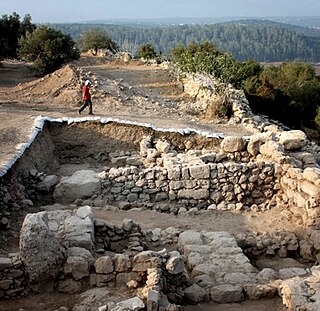
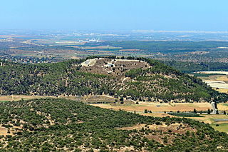
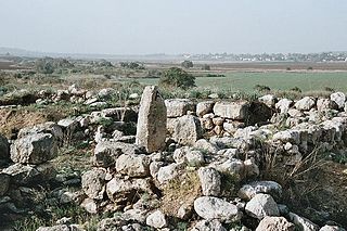
KhirbetQeiyafa, also known as Elah Fortress and in Hebrew as Horbat Qayafa, is the site of an ancient fortress city overlooking the Elah Valley and dated to the first half of the 10th century BCE. The ruins of the fortress were uncovered in 2007, near the Israeli city of Beit Shemesh, 30 km (20 mi) from Jerusalem. It covers nearly 2.3 ha and is encircled by a 700-meter-long (2,300 ft) city wall constructed of field stones, some weighing up to eight tons. Excavations at site continued in subsequent years. A number of archaeologists, mainly the two excavators, Yosef Garfinkel and Saar Ganor, have claimed that it might be one of two biblical cities, either Sha'arayim, whose name they interpret as "Two Gates", because of the two gates discovered on the site, or Neta'im; and that the large structure at the center is an administrative building dating to the reign of King David, where he might have lodged at some point. This is based on their conclusions that the site dates to the early Iron IIA, ca. 1025–975 BCE, a range which includes the biblical date for the biblical Kingdom of David. Others suggest it might represent either a North Israelite, Philistine, or Canaanite fortress, a claim rejected by the archaeological team that excavated the site. The team's conclusion that Khirbet Qeiyafa was a fortress of King David has been criticised by some scholars. Garfinkel (2017) changed the chronology of Khirbet Qeiyafa to ca. 1000–975 BCE.

<span class="mw-page-title-main">Elihu Grant</span>

Elihu Grant was an American scholar and writer on Palestine.

<span class="mw-page-title-main">Tell es-Safi</span> Place in Hebron, Mandatory Palestine

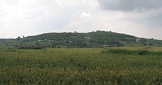
Tell es-Safi was an Arab Palestinian village, located on the southern banks of Wadi 'Ajjur, 35 kilometers (22 mi) northwest of Hebron which had its Arab population expelled during the 1948 Arab–Israeli war on orders of Shimon Avidan, commander of the Givati Brigade.

<span class="mw-page-title-main">Place names of Palestine</span>

Many place names in Palestine were Arabized forms of ancient Hebrew and Canaanite place-names used in biblical times or later Aramaic formations. Most of these names have been handed down for thousands of years though their meaning was understood by only a few. The cultural interchange fostered by the various successive empires to have ruled the region is apparent in its place names. Any particular place can be known by the different names used in the past, with each of these corresponding to a historical period. For example, the city of Beit Shean, today in Israel, was known during the Israelite period as Beth-shean, under Hellenistic rule and Roman rule as Scythopolis, and under Arab and Islamic rule as Beisan.

<span class="mw-page-title-main">Tell ej-Judeideh</span> Ancient archaeological site in the Shfelah

Tell ej-Judeideh is a tell in modern Israel, lying at an elevation of 398 metres (1,306 ft) above sea-level. The Arabic name is thought to mean, "Mound of the dykes." In Modern Hebrew, the ruin is known by the name Tell Goded.

References

  1. Issa, Rana (2021-04-19). "Chapter 16 Missionary Philology and the Invention of Bibleland". Tracing the Jerusalem Code. De Gruyter. pp. 309–327. doi:10.1515/9783110639476-017. ISBN   9783110639476. S2CID   233588992. For Robinson and Smith, the natives unwittingly carry the "divine dialect" of the land. Based on information from their lips, Robinson turns Ain Shams into the Bible's Beit Shemesh, Ain and Beit being so seemingly common as to be interchangeable.
  2. Robinson, Edward (1841). Biblical researches in Palestine, mount Sinai and Arabia Petrea. Vol. 3. J.Murray. pp. 17–20. The name 'Ain Shems implies a fountain; but there is now here no water of any kind, so called. The place to which the Arabs give this name, consists of the ruins of a modern Arab village of moderate size, with a Wely, all evidently built up with ancient materials. But just on the West of this village, upon and around the plateau of a low swell or mound between the Sărâr on the North and a smaller Wady on the South, are the manifest traces of an ancient site... Both the name and the position of this spot, seem to indicate the site of the ancient Beth-shemesh of the Old Testament. That city is described by Eusebius and Jerome, as seen from the road leading from Eleutheropolis to Nicopolis ('Amwâs), at ten Roman miles from the former city; and as they assign nearly the same distances from Eleutheropolis to Zorah, Zanoah, and Jarmuth, it is obvious that Beth-shemesh lay in the vicinity of these places. And so we had already found it, surrounded by Zânû'a in the East, Sur'ah in the N. N. E. and Yarmûk in the S. W. Indeed, from the existence of these names, and their coincidence with the accounts of Eusebius and Jerome, we had been able chiefly to trace out and fix the site of Eleutheropolis at Beit Jibrîn. The words Beit (Beth) and 'Ain are so very common in the Arabic names of Palestine, that it can excite no wonder should there be an exchange, even without any obvious ground. In the same manner, the ancient Beth-shemesh (Heliopolis) of Egypt, is known in Arabian writers as 'Ain Shems; although at present the name is applied specifically, only to a well at some distance from its site.
  3. 1 2 3 Beit Shemesh – Biblical city on the border between Judah and Philistia Archived 14 August 2007 at the Wayback Machine , Israel Ministry of Foreign Affairs. Retrieved 23 November 2007.
  4. BibleHub.com, Beth Shemesh, quoting Strong's Concordance etc. Archived 8 September 2015 at the Wayback Machine
  5. Ben-Yosef, Sefi [in Hebrew], ed. (n.d.). Israel Guide – Judaea (A useful encyclopedia for the knowledge of the country) (in Hebrew). Vol. 9. Jerusalem: Keter Publishing House, in affiliation with the Israel Ministry of Defence. p. 31. OCLC   745203905., s.v. סקירה היסטורית-ישובית
  6. Bunimovitz, Shlomo; Lederman, Tzvi (2016). Tel Beth-Shemesh: A Border Community in Judah. Penn State Press. p. 378. ISBN   978-1-57506-453-6.
  7. Vaknin, Yoav; Shaar, Ron; Lipschits, Oded; Mazar, Amihai; Maeir, Aren M.; Garfinkel, Yosef; Freud, Liora; Faust, Avraham; et al. (2022-10-24). "Reconstructing biblical military campaigns using geomagnetic field data". Proceedings of the National Academy of Sciences. 119 (44): e2209117119. Bibcode:2022PNAS..11909117V. doi:10.1073/pnas.2209117119. PMC   9636932 . PMID   36279453.
  8. 1 2 Shlomo Bunimovitz and Zvi Lederman, Beth-Shemesh: A Biblical Border City between Judah and Philistia, Tel Aviv University, 2000 Archived 5 October 2016 at the Wayback Machine , retrieved 2016-09-01
  9. בועז גרוס. "ממצאי חפירת ההצלה במזרח תל בית שמש". מכון ישראלי לארכיאולוגיה.
  10. אילת כהנא (23 April 2020). "בית הכנסת העתיק שנחשף בתל בית־שמש יפורק". www.makorrishon.co.il. Retrieved 2020-05-24.
  11. Claudine Dauphin (1998). La Palestine byzantine, Peuplement et Populations, Vol. III: Catalogue. BAR International Series 726. Oxford: Archeopress. p. 909.
  12. C. R. Conder & H. H. Kitchener (1883). The Survey of Western Palestine. Vol. III. London: The Committee of the Palestine Exploration Fund. p. 60.
  13. 1 2 M. V. Guérin (1869). Description géographique, historique et archéologique de la Palestine. Vol. Judée II. Paris. pp. 18–22.{{cite book}}: CS1 maint: location missing publisher (link)
  14. Shragai, Nadav (27 April 2009). "The Legend of Ambushed Palmach Squad '35'". Haaretz. Archived from the original on 21 July 2018. Retrieved 2023-01-05.
  15. Mackenzie, D., "Excavations at Ain Shems (Beth-Shemesh)", Palestine Exploration Fund Annual 1, pp. 41–94, 1911
  16. Mackenzie, D., "Excavations at Ain Shems (Beth-Shemesh)" Palestine Exploration Fund Annual 2, 1912–1913
  17. Grant, E., "Beth Shemesh (Palestine). Progress of the Haverford Archaeological Expedition", Biblical and Kindred Studies 2. Haverford, PA: Haverford College, 1929
  18. Grant, E., "Ain Shems Excavations (Palestine) 1928–1929–1930–1931, Part 1", Biblical and Kindred Studies 3, Haverford, PA: Haverford College, 1931
  19. Grant, E., "Ain Shems Excavations (Palestine) 1928–1929–1930–1931, Part 2", Biblical and Kindred Studies 4, Haverford, PA: Haverford College, 1932
  20. Grant, E., "Rumeileh Being Ain Shems Excavations (Palestine), Part 3. Biblical and Kindred Studies 5", Haverford, PA: Haverford College.
  21. Grant, E., and Wright, G. E., "Ain Shems Excavations (Palestine), Part 4 (Pottery)", Biblical and Kindred Studies 7, Haverford, PA: Haverford College, 1938
  22. Grant, E., and Wright, G. E., "Ain Shems Excavations (Palestine), Part 5 (Text)", Biblical and Kindred Studies 8, Haverford, PA: Haverford College, 1939
  23. Fossé, Cécile, et al., "Archaeo-Material Study of the Cuneiform Tablet from Tel Beth-Shemesh", Tel Aviv 51.1, pp. 3-17, 2024
  24. Bunimovitz, Shlomo, and Zvi Lederman, "Canaanite resistance: the Philistines and Beth-Shemesh—a case study from Iron Age I", Bulletin of the American Schools of Oriental Research 364.1, pp. 37-51, 2011
  25. Bunimovitz, S., and Lederman, Z., "A Border Case: Beth-Shemesh and the Rise of Ancient Israel", in Israel in Transition: From the Late Bronze II to Iron IIa (c. 1250–850 B.C.E.), Vol. 1: The Archaeology, ed. L. L. Grabbe. Library of Hebrew Bible/Old Testament Studies 491; European Seminar in Historical Methodology 7, New York: T & T Clark, pp. 21–31, 2008
  26. Bunimovitz, S., and Lederman, Z., "The Archaeology of Border Communities. Tel Beth-Shemesh Renewed Excavations, Part 1: The Iron Age", Near Eastern Archaeology 72, pp. 116–42, 2009
  27. 1 2 Hasson, Nir (30 July 2012). "National Seal found by Israeli archeologists may give substance to Samson legend". Haaretz. Archived from the original on 16 November 2013. Retrieved 3 September 2013.
  28. 050shlomi@gmail.com (2021-03-23). "הפארק הארכיאולוגי החדש שיוקם בבית שמש בהשקעה של עשרות מיליוני שקלים | כל העיר". כל העיר ירושלים (in Hebrew). Retrieved 2023-12-12.{{cite web}}: CS1 maint: numeric names: authors list (link)
  29. "הישג לארכיאולוגים: כביש 38 שאמור לחצות את תל בית שמש יצומצם". הארץ (in Hebrew). Retrieved 2023-12-12.
  30. בונימוביץ, שלמה; לדרמן, צבי; Bunimovitz, Shlomo; Lederman, Zvi (2003). "The Last Days of Beth Shemesh and the Pax Assyriaca in the Shephelah of Judah / חורבנה הסופי של בית-שמש ו"השלום האשורי" בשפלת יהודה". Eretz-Israel: Archaeological, Historical and Geographical Studies / ארץ-ישראל: מחקרים בידיעת הארץ ועתיקותיה. כז: 41–49. ISSN   0071-108X.
  31. "Israel Antiquities Authority". www.antiquities.org.il. Retrieved 2023-12-12.
  32. "נתיבי ישראל בממלכת יהודה". מוזיאון ארצות המקרא (in Hebrew). Retrieved 2023-12-12.
  33. 1 2 "מי חשוב יותר, כביש 38 או המלך חזקיהו?". הארץ (in Hebrew). Retrieved 2023-12-12.
  34. Amir, Ayala; Frumkin, Amos; Zissu, Boaz; Maeir, Aren M.; Goobes, Gil; Albeck, Amnon (7 May 2022). "Sourcing Herod the Great's calcite-alabaster bathtubs by a multi-analytic approach". Scientific Reports. 12 (1): 7524. Bibcode:2022NatSR..12.7524A. doi:10.1038/s41598-022-11651-5. PMC   9079073 . PMID   35525885.
  35. 1 2 3 4 Nir Hasson (20 September 2014). "Archaeologists discover impressive Byzantine-era compound near Beit Shemesh". Haaretz. Archived from the original on 20 September 2014. Retrieved 20 September 2014.
  36. Daniel K. Eisenbud (20 December 2017). "Artifacts from 1,500-year-old Monastery and Church unearthed in Beit Shemesh". The Jerusalem Post . Archived from the original on 2 January 2018. Retrieved 1 January 2018.