Texas State Highway Loop 1

Last updated

Texas Loop 1.svg Toll Texas 1 new.svg

State Highway Loop 1

MoPac Expressway
Texas State Highway Loop 1
Loop 1 highlighted in red
Route information
Length25.698 mi [1]  (41.357 km)
Existed1967–present
Major junctions
South endTexas 45.svg SH 45
Major intersections
North endToll Texas 45 new.svg SH 45 Toll
Location
Country United States
State Texas
Counties Travis, Williamson
Highway system
Old Texas 1.svg SH 1 Texas FM 1.svg FM 1

Loop 1 is a freeway which provides access to the west side of Austin in the U.S. state of Texas. It is named Mopac Expressway (or, according to some highway signs, Mopac Boulevard) after the Missouri Pacific Railroad (or "MoPac"). Local residents almost always use the name "MoPac" rather than calling the road by its number, [2] [3] which can cause much confusion, for few signs along the road use this name. [4] [5]

Contents

The original section of the highway was built in the 1970s along the right-of-way of the Missouri Pacific Railroad (now owned by Union Pacific), with the railroad tracks running in the highway median between West 8th Street and Northland Drive. To the north, the tracks run along the east side of newer sections of the highway from Northland Drive to Braker Lane.

History

Route designation

The first mention of Loop 1 in public record was in 1929. In 1944, the City of Austin Planning Commission (CMAC) proposed that the highway be built in parts of the under-utilized right of way owned by the MoPac Railroad. Thus, the highway was eventually given the nickname "MoPac" for its proximity to the railroad. The current Loop 1 was designated on October 27, 1967, from US 290 northward to Farm to Market Road 1325 (FM 1325). [6] On October 24, 1985, the designation was extended southward from US 290 to SH 45. [1]

Expressway construction (1969 to 2006)

This table contains the dates of the construction of segments of the road. [7] [8] [9]

FromToLength
(mi)
Length
(km)
Project
start
Project
completion
Notes
RM 2244
(Bee Cave Road)
RM 2222
(Northland Road)
5.48.7February 1969November 1975Loop 1 project started with
construction of the 45th Street
Interchange in February 1969.
RM 2222 US 183 4.67.4September 1977June 1981Northern terminus of Loop 1 completed,
until July 1989 - with construction of the freeway extension to FM 734.
RM 2244 Loop 360 1.93.1January 1979March 1982Southern terminus of Loop 1 completed,
until October 1989 - with construction of the freeway extension to US 290.
Loop 360US 2901.62.6October 1983October 1989Southern terminus of Loop 1 completed,
until November 1990 - with construction of the roadway
extension to Slaughter Lane.
US 183FM 1325 (Burnet Road)
and FM 734 (Parmer Lane)
3.76.0January 1986July 1989Northern terminus of Loop 1 completed,
until October 2006 - with construction of the SH 45 North/
Loop 1 Connector toll road.
Stack interchange at US 183 is constructed -
involved major freeway improvements between Steck Avenue and US 183,
from March 1987 to June 1992.
US 290 Slaughter Lane3.65.8January 1988November 1990Southern terminus of Loop 1 completed,
until July 1991 - with construction of the roadway
extension to La Crosse Avenue.
Slaughter LaneLa Crosse Avenue1.01.6July 1989July 1991Southern terminus of Loop 1 completed,
until May 1994 - with construction of the roadway
extension to State Highway 45 .
La Crosse AvenueSH 452.54.0November 1989May 1994Southern terminus of Loop 1 completed.
FM 734SH 45 North/
Loop 1 Interchange
4.06.4February 2003October 2006Construction on the SH 45 North Interchange
began in September 2003.
Northern terminus of Loop 1 completed.

Route description

A stretch of Loop 1 over the Hancock Drive bridge, looking north-northwest. The Union Pacific railway is visible in the foreground. Mopac Expressway.jpg
A stretch of Loop 1 over the Hancock Drive bridge, looking north-northwest. The Union Pacific railway is visible in the foreground.

Loop 1's southern terminus is at the beginning of the State Highway 45 stub south of Austin. It passes through the Circle C Ranch housing development and the Edwards Aquifer and intersects SH 71/US 290 (Ben White Boulevard) and Loop 360 (Capital of Texas Highway). It crosses the Colorado River near downtown Austin; the view of the Texas State Capitol from the bridge became one of the Capitol View Corridors protected under state and local law from obstruction by tall buildings in 1983. [10] North of the river, the highway runs parallel to the Balcones Fault and the Missouri-Pacific Railroad (Union Pacific) before it intersects US 183 (Research Boulevard) northwest of downtown. Loop 1 travels concurrently with Farm to Market Road 1325 for several miles before the non-tolled freeway ends at Parmer Lane, spanning a distance of 22.061 miles (35.504 km).

Loop 1 is designated a scenic roadway by the City of Austin. [11]

Major construction projects

Loop 1 Toll

North of Parmer Lane, Loop 1 continues as a limited-access toll road to the SH 45 North/Loop 1 interchange, spanning 3 miles (4.8 km). Frontage roads flank either side of the toll road to Merrilltown Drive.

The Texas Department of Transportation completed construction of the tollway as part of the 2002 Central Texas Turnpike Project (CTTP). SH 45 North, also part of the project, provides freeway access to Interstate 35 from Loop 1. The 2002 CTTP was scheduled to be completed in September 2007. However, certain sections of the project, including Loop 1 opened early and more than $100 million under budget.

If and when SH 45 is completed to the south of Austin between FM 1626 and I-35, Loop 1 will effectively serve as a full western loop to the city, being directly connected to SH 45 (and indirectly to I-35) at both ends.

MoPac Improvement Project

1 Express Lane free.svg

Loop 1 Express

Mopac Improvement Project
Location Austin
Existed2017–present

Since 1994, TxDOT has proposed the addition of managed lanes to portions of Loop 1. The MoPac Improvement Project [12] was relaunched in July 2010 by the Central Texas Regional Mobility Authority (CTRMA). In December 2010, four alternative proposals were presented to the public, each of which would add one or more lanes; the "no-build" alternative was also presented. The additions would not increase the right-of-way of the highway, but would be created by reducing the width of existing lanes and reducing and/or eliminating shoulders. An environmental study was completed in August 2012 with a Finding Of No Significant Impact and a recommendation of one new travel lane in each direction, operated as express lanes. [13] Construction began in 2013, and was originally scheduled for completion in September 2015, but by August 2016, the Central Texas Regional Mobility Authority announced further delays. [14] The first of four tolled sections, specifically the northbound toll lane from RM 2222 to Parmer Lane, opened on October 17, 2016. The remainder of the northbound express lane, from Cesar Chavez Street to Parmer Lane, opened on October 7, 2017, and the entire southbound express lane opened on October 28, 2017.

MoPac Intersections Project

In 2013, CTRMA and TxDOT initiated an environmental study to analyze the best options to improve the MoPac intersections at Slaughter Lane and La Crosse Avenue. In December 2015, the study was completed with a Finding Of No Significant Impact for the project, which allowed it to move forward. [15] The selected design included replacing the at-grade intersection at Slaughter Lane with a diverging diamond interchange (DDI) [16] and the at-grade intersection at La Crosse Avenue with a diamond interchange. The project broke ground in January 2018 with Webber, LLC as the general contractor.

On August 10, 2018, the at-grade Slaughter Lane intersection was rerouted to the south as construction began on an overpass bridge on the original alignment. [17] The completed DDI opened to traffic on November 11, 2018, with final completion occurring in Spring 2019. The La Crosse Avenue intersection began construction in Fall 2018. On March 29, 2019, the La Crosse Avenue at-grade intersection was closed for reconstruction as a bridge. [18] The La Crosse Avenue bridge and intersection opened to traffic on April 16, 2020. The full project, including surrounding sound walls and retention ponds, was officially completed on December 16, 2020. [19] [20]

MoPac South

In 2013, CTRMA and TxDOT initiated an environmental study of the MoPac corridor from Cesar Chavez Street to Slaughter Lane. [21] The environmental study identified the Express Lane(s) Alternative as the Recommended Build Alternative. [22] In October 2015, six proposals were presented to the public, each of which would add one of more express lanes; the "no-build" alternative was also presented. [23] In February 2016, the project was put on hold by a Save Our Springs lawsuit claiming the project had not complied with the National Environmental Policy Act's requirements for environmental studies. [24] The lawsuit was settled on July 18, 2018 with a ruling in favor of CTRMA by the 5th Circuit U.S. Court of Appeals. [25] However, the project was further delayed by a state moratorium on toll projects receiving funding from State Propositions 1 and 7. TxDOT gave CTRMA preliminary approval to resume planning for MoPac South in August 2019. [26] In November 2021, the project was officially revitalized with a virtual open house, and it is currently in public planning phases.

Exit list

All exits are unnumbered.

CountyLocationmikmDestinationsNotes
Travis Austin 0.00.0West plate.svg
Texas 45.svg
SH 45 west
0.71.1South Bay LaneAt-grade intersection; dead end both directions, turnaround only
1.52.4La Crosse Avenue
2.33.7Slaughter LaneDiverging Diamond Interchange
2.94.7Davis LaneSouthbound exit and northbound entrance
4.77.6William Cannon Drive
6.09.7US 290.svgTexas 71.svgHospital sign.svg US 290  / SH 71  / Southwest Parkway Johnson City, Llano, Sunset Valley Access to Baylor Scott & White Medical Center – Austin
6.610.6Frontage RoadSouthbound exit only
7.512.1Texas Loop 360.svg Loop 360 (Capital of Texas Highway)Only one exit ramp travels from southbound Loop 1 to southbound Loop 360; all others are at-grade
8.914.3Barton Skyway
9.815.8Texas RM 2244.svg RM 2244 (Bee Caves Road) / Wallingwood Drive Rollingwood, West Lake Hills
Roberta Crenshaw Bridge over the Colorado River
Begin plate blue.svg
1 Express Lane free.svg
Loop 1 Express begins
South end of variable toll lanes
10.516.9Cesar Chavez Street / 5th Street / Lake Austin Boulevard
11.218.0Enfield Road
11.718.8Windsor Road
12.319.8Westover Road / Northwood Road
12.920.8Hospital sign.svg 35th Street - Camp Mabry Access to Seton Shoal Creek Hospital
13.822.245th Street
14.823.8Texas RM 2222.svg RM 2222 (Northland Drive)
1 Express Lane free.svg Loop 1 Express Access point for variable toll lanes
15.925.6Far West Boulevard
16.626.7Anderson Lane / Spicewood Springs RoadDirect northbound exit and southbound entrance (southbound exit signed at Steck Avenue)
17.127.5Steck AvenueNo direct northbound entrance
17.327.8(no name)Northbound exit only; replaced by northbound collector distributor road underneath Steck Avenue [27]
18.029.0US 183.svgHospital sign.svg US 183 (Research Boulevard)No direct southbound exit to US 183 north (signed at Capital of Texas Highway), access to Seton Northwest Hospital
18.730.1 Capital of Texas Highway
19.130.7Braker Lane - Q2 Stadium Direct southbound exit and northbound entrance (northbound exit signed at Capital of Texas Highway)
20.533.0South plate.svg
Texas FM 1325.svg
Hospital sign.svg FM 1325 south (Burnet Road) / Duval Road
South end of FM 1325 overlap, access to North Austin Medical Center
End plate blue.svg
1 Express Lane free.svg
Loop 1 Express ends
North end of variable toll lanes; despite being signed as such, no direct access to FM 734 (Parmer Lane) exists
21.734.9Texas FM 734.svg FM 734 (Parmer Lane)
22.436.0Scofield Ridge ParkwayLast free northbound exit before toll road begins; no direct southbound exit
22.436.0End plate.svg
Texas Loop 1.svg
Loop 1 ends
Begin plate blue.svg
Toll Texas 1 new.svg
Loop 1 Toll begins
Northern terminus of Loop 1 (Mopac Expressway); southern terminus of Loop 1 Toll
23.137.2Texas FM 1325.svg FM 1325  / Wells Branch Parkway / Howard Lane, Merrilltown DriveRail Sign.svg Howard station
24.038.6Toll plaza
TravisWilliamson
county line
24.539.4Shoreline DriveNo southbound exit
Williamson 25.641.2Toll Texas 45 new.svgTo plate blue.svg
I-35.svg
SH 45 Toll to I-35
1.000 mi = 1.609 km; 1.000 km = 0.621 mi

See also

Related Research Articles

<span class="mw-page-title-main">U.S. Route 290</span> Highway in Texas

U.S. Route 290 is an east–west U.S. Highway located entirely within the state of Texas. Its western terminus is at Interstate 10 southeast of Segovia, and its eastern terminus is at Interstate 610 in northwest Houston. It is the main highway between Houston and Austin and is a cutoff for travelers wanting to bypass San Antonio on Interstate 10. Throughout its length west of Austin, US 290 cuts across mountainous hills comprising the Texas Hill Country and the Edwards Plateau; between Austin and Houston, the highway then travels through gradually hilly grasslands and pine forests comprising the Gulf Coastal Plains.

<span class="mw-page-title-main">Texas State Highway 121</span> Highway in Texas

State Highway 121 is a state highway angling from southwest to northeast through north central Texas. It runs from Cleburne, Texas at US 67 to SH 78 in Bonham, Texas, just north of a junction with US 82.

<span class="mw-page-title-main">Texas State Highway Loop 360</span> Highway in Texas

Loop 360 is a 13.99-mile (22.51 km) loop route in Austin in the U.S. state of Texas. Loop 360 is a scenic highway winding through the hills of West Austin. The road is described by the Texas Department of Transportation (TxDOT) as "a 4-lane depressed median arterial with at-grade signalized intersections." In 2021, the average daily traffic was 58,497 vehicles at the most traveled point, north of RM 2222.

<span class="mw-page-title-main">Superstreet</span> Type of high capacity intersection

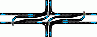
A superstreet, also known as a restricted crossing U-turn (RCUT), J-turn, or reduced conflict intersection (RCI), is a type of road intersection that is a variation of the Michigan left. In this configuration, in contrast to the Michigan left, traffic on the minor road is not permitted to proceed straight across the major road or highway. Drivers on the minor road wishing to turn left or go straight must turn right onto the major road, then, a short distance away, queue (wait) into a designated U-turn lane in the median. When traffic clears, they complete the U-turn and then either go straight or make a right turn when they intersect the other half of the minor road.

<span class="mw-page-title-main">Texas State Highway Beltway 8</span> Highway in Texas

Beltway 8 (BW8), the Sam Houston Parkway, along with the Sam Houston Tollway, is an 88-mile (142 km) beltway around the city of Houston, Texas, United States, lying entirely within Harris County.

The President George Bush Turnpike (PGBT) is a 52-mile (84 km) controlled-access toll road running through the northern, northeastern and western suburbs, forming a partial beltway around Dallas, Texas, United States. It is named for the late George H. W. Bush, the 41st president of the United States. At its west end near Belt Line Road in Irving, State Highway 161 continues southwest to Interstate 20 (I-20) in Grand Prairie. The discontinuous free frontage roads along the turnpike from I-35E in Carrollton east to its end at I-30 in Garland are assigned the State Highway 190 designation. SH 190 signage appears only along the Rowlett, Garland, Richardson, Plano, and Carrollton sections of the frontage road with the undersign "frontage road only". At intersections with city streets, only the Bush Turnpike signs are displayed, not the SH 190 signage. Prior to the construction of the main lanes as a tollway, SH 190 was used as the name of the planned main lanes too. Similarly, the part west of I-35E was planned as part of SH 161. Bush Turnpike is signed as a north–south road from I-20 to I-35E, an east–west road from I-35E to the Merritt Main Lane Gantry and as a north–south road from the Merritt Main Lane Gantry to I-30, as Bush Turnpike makes a nearly 90-degree curve in both places.

<span class="mw-page-title-main">Texas State Highway 114</span> State highway in Texas, United States

State Highway 114 is a state highway that runs from the Dallas-Fort Worth Metroplex westward across Texas to the New Mexico state line, where it becomes New Mexico State Road 114, which eventually ends at Elida, New Mexico at US 70 / NM 330.

<span class="mw-page-title-main">TxTag</span> Electronic toll collection system in Texas, United States

TxTag, operated by the Texas Department of Transportation (TxDOT), is one of three interoperable electronic toll collection systems in Texas. The system is also interoperable with the K-TAG system used in Kansas and the Pikepass system used in Oklahoma.

<span class="mw-page-title-main">Texas State Highway 45</span> State highway in Texas

State Highway 45 is a freeway loop around Austin, Texas, that exists in two open segments. The official designation of SH 45 is such to form a complete loop around Austin, a distance of roughly 80 miles (130 km).

<span class="mw-page-title-main">Texas State Highway Loop 375</span> Partial beltway of El Paso, Texas

Loop 375 is a beltway that partially encircles the city of El Paso, Texas. The beltway is mostly a freeway, except for its northern section, which includes at-grade intersections. The highway passes through various areas of El Paso, funneling traffic within and around the city. The road is known locally under different names, as Woodrow Bean Transmountain Drive in the northern section, Purple Heart Memorial Freeway in the northeastern section, Joe Battle Boulevard in the eastern section, the César Chávez Border Highway in the southern section, and the Border West Expressway on the southwest section.

<span class="mw-page-title-main">Texas State Highway Loop 49</span> Highway in Texas

Loop 49 is a currently 32-mile (51 km) circular freeway that, along with I-20, will encircle the city of Tyler and serve other various communities in Northeast Texas upon its completion. Routing of the loop north of I-20 bypasses Lindale to the west and passes by the west and south sides of Tyler south of I-20. The highway interconnects suburban areas and areas of potential development around Tyler with I-20 and provides local areas easier access to the Dallas–Fort Worth metroplex.

<span class="mw-page-title-main">Central Texas Regional Mobility Authority</span>

The Central Texas Regional Mobility Authority is an independent government agency created in 2002 to improve the transportation system in Travis and Williamson Counties in Texas. The Mobility Authority is headquartered at 3300 N. IH 35 in Austin.

<span class="mw-page-title-main">U.S. Route 183 in Texas</span> Highway in Texas

U.S. Route 183 (US 183) is a north-south U.S. highway that begins in Texas in Refugio at an intersection with US 77 concurrent with US 77 Alt. The highway runs through many small communities with Austin being the only major city along its route. The highway exits Texas concurrent with US 70, crossing into Oklahoma.

<span class="mw-page-title-main">Interstate 35 in Texas</span> Section of Interstate Highway in Texas, United States

Interstate 35 (I-35) is a major north–south Interstate Highway that runs from Laredo, Texas near the Mexican border to Duluth, Minnesota. In Texas, the highway begins in Laredo and runs north to the Red River north of Gainesville, where it crosses into Oklahoma. Along its route, it passes through the cities of San Antonio, Austin, and Waco before splitting into two branch routes just north of Hillsboro: I-35E heads northeast through Dallas, while I-35W turns northwest to run through Fort Worth. The two branches rejoin in Denton to again form I-35, which continues to the Oklahoma state line. The exit numbers for I-35E maintain the sequence of exit numbers from the southern segment of I-35, and the northern segment of I-35 follows on from the sequence of exit numbers from I-35E. I-35W maintains its own sequence of exit numbers.

<span class="mw-page-title-main">Farm to Market Road 734</span>

Farm to Market Road 734 is a 19.3-mile (31.1 km) farm-to-market road in Travis and Williamson counties in the U.S. state of Texas. It is the state-maintained portion of Parmer Lane, a major arterial road in the region. Most of the route's length is located just within the northern city limits of Austin, with portions located in Cedar Park, Leander, and unincorporated areas.

<span class="mw-page-title-main">Farm to Market Road 1325</span>

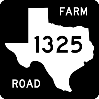
Farm to Market Road 1325 is a 7.2-mile (11.6 km) roadway located in Travis and Williamson counties of Texas. Along much of its length it is referred to as Burnet Road.

Wurzbach Parkway is a part freeway and part major arterial road in San Antonio, Texas, built to provide relief on Interstate 410 (I-410) and Loop 1604 on the city's north side. The highway is named for Harry M. Wurzbach, who represented the San Antonio area in Congress as a Republican in the 1920s and 1930s. The congressman's name was first applied to the connecting Wurzbach Road. The highway's western third was built as an expressway with at-grade intersections and the remainder as a freeway. The opening in September 2015 of an interchange with U.S. Highway 281 completed primary construction of the parkway. The highway, along with part of Wurzbach Road near the Ingram Park Mall, is maintained by the Texas Department of Transportation despite not carrying a state highway designation. Rather, it is being developed and maintained under the Principal Arterial State System (PASS) program, under which it is designated as PASS Project 1502. The parkway includes an interchange with US 281, and drivers can access I-10 and I-35 via local roads that extend the parkway.

There are approximately 25 current toll roads in the state of Texas. Toll roads are more common in Texas than in many other U.S. states, since the relatively low revenues from the state's gasoline tax limits highway planners' means to fund the construction and operation of highways.

Northwest Hills, sometimes referred to as Far West after its main street, is a suburban neighborhood in the northwestern part of Austin, Texas, United States.

References

  1. 1 2 Transportation Planning and Programming Division (n.d.). "State Highway Loop No. 1". Highway Designation Files. Texas Department of Transportation . Retrieved March 24, 2013.
  2. "Confusing Road Names in Austin". Archived from the original on October 25, 2011. Retrieved January 2, 2012.
  3. "Austin Slang - AOL Travel News". Archived from the original on January 20, 2012. Retrieved January 2, 2012.
  4. "Decipher Austin streets | Always Austin". Archived from the original on April 26, 2012. Retrieved January 2, 2012.
  5. "MoPac Expressway. Just wondering | Austin | Yelp". Archived from the original on March 4, 2016. Retrieved January 2, 2012.
  6. "Proposed MoPac Boulevard Is Designated as Loop No. 1". Austin Statesman. October 31, 1967. ProQuest   1515952796.(subscription required)
  7. "Introduction: Mopac Improvement Project, April 2012" (PDF). Retrieved April 1, 2012.
  8. "The MoPac 1 Project will study feasibility of managed lanes for Loop 1, and included in the Mobility 2030 Plan that was adopted by CAMPO in June 2005". Archived from the original on February 23, 2006. Retrieved June 1, 2005.
  9. "What Native American tribe was most common in the area?". Texas Department of Transportation. Archived from the original on May 7, 2010. Retrieved January 24, 2010.
  10. "Downtown Development and Capitol View Corridors" (PDF). Downtown Austin Commission. June 27, 2007. Archived (PDF) from the original on November 15, 2017. Retrieved November 10, 2017.
  11. "Code of Ordinances § 25-10-7". City of Austin. Retrieved October 28, 2022 via Municode.
  12. "MoPac Improvement Project". Archived from the original on December 30, 2010. Retrieved February 19, 2011.
  13. Ham, Justin. "Finding" (PDF). MoPac Improvement Project. U.S. Dept. of Transportation, Federal Highway Administration, Texas Division. Archived (PDF) from the original on May 10, 2017. Retrieved September 5, 2016.
  14. Jechow, Andy (August 25, 2016). "Weather, paving corrections push back North MoPac opening date". KXAN-TV. Archived from the original on August 29, 2016. Retrieved September 5, 2016.
  15. "About MoPac Intersections". Archived from the original on February 19, 2018. Retrieved February 18, 2018.
  16. "MoPac South: Diverging Diamond Interchange Simulation". Central Texas Regional Mobility Authority. April 16, 2015. Archived from the original on December 13, 2021. Retrieved September 30, 2018.
  17. Crown, Rosemond (June 11, 2018). "Construction to close Slaughter lane at MoPac for 6 months". KXAN. Archived from the original on April 2, 2019. Retrieved April 2, 2019.
  18. Cicale, Nicholas (March 29, 2019). "Detours for La Crosse Avenue at MoPac go into effect March 29". Community Impact Newspaper. Archived from the original on April 2, 2019. Retrieved April 2, 2019.
  19. Cicale, Nicholas (December 16, 2020). "MoPac projects at Slaughter Lane, La Crosse Ave. completed". impact. Retrieved November 5, 2021.
  20. "MoPac Intersections". www.txdot.gov. Texas Department of Transportation. Archived from the original on September 27, 2018. Retrieved September 27, 2018. Note: This source incorrectly refers to interchanges as intersections.
  21. "Project Overview | MoPac South Environmental Study". www.mopacsouth.com. Retrieved November 5, 2021.
  22. "Environmental Study | MoPac South Environmental Study". www.mopacsouth.com. Retrieved November 5, 2021.
  23. "Mobility authority unveils MoPac South options". Austin Monitor. October 22, 2015. Retrieved November 5, 2021.
  24. "Group files lawsuit to stop South MoPac, SH 45 SW projects". KXAN Austin. February 25, 2016. Retrieved November 5, 2021.
  25. Cicale, Nicholas (July 19, 2018). "Court rules on the side of CTRMA and TxDOT in lawsuit against South Austin transportation projects". impact. Retrieved November 5, 2021.
  26. Ortiz, Edmond (November 7, 2019). "Austin: Mobility Authority Resumes Planning for New MoPac South Toll Roads". Virtual Builders Exchange. Retrieved November 5, 2021.
  27. "Mopac Improvement: Steck Avenue Collector-Distributor Lane Construction". Archived from the original on June 9, 2016. Retrieved June 22, 2016.
Template:Attached KML/Texas State Highway Loop 1
KML is not from Wikidata