Chiricahua is a band of Apache Native Americans.
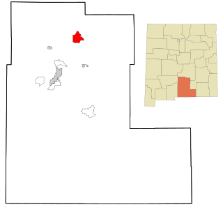
Mescalero is a census-designated place (CDP) in Otero County, New Mexico, United States, located on the Mescalero Apache Reservation. The population was 1,338 at the 2010 census.

The Pecos River originates in north-central New Mexico and flows into Texas, emptying into the Rio Grande. Its headwaters are on the eastern slope of the Sangre de Cristo mountain range in Mora County north of Pecos, New Mexico, at an elevation of over 12,000 feet (3,700 m). The river flows for 926 miles (1,490 km) before reaching the Rio Grande near Del Rio. Its drainage basin encompasses about 44,300 square miles (115,000 km2).
The Apache are several Southern Athabaskan language–speaking peoples of the Southwest, the Southern Plains and Northern Mexico. They are linguistically related to the Navajo. They migrated from the Athabascan homelands in the north into the Southwest between 1000 and 1500 CE.
Lipan Apache are a band of Apache, a Southern Athabaskan Indigenous people, who have lived in the Southwest and Southern Plains for centuries. At the time of European and African contact, they lived in New Mexico, Colorado, Oklahoma, Texas, and northern Mexico. Historically, they were the easternmost band of Apache.

Victorio was a warrior and chief of the Warm Springs band of the Tchihendeh division of the central Apaches in what is now the American states of Texas, New Mexico, Arizona, and the Mexican states of Sonora and Chihuahua.

Mescalero or Mescalero Apache is an Apache tribe of Southern Athabaskan–speaking Native Americans. The tribe is federally recognized as the Mescalero Apache Tribe of the Mescalero Apache Reservation, located in south-central New Mexico.

Jicarilla Apache, one of several loosely organized autonomous bands of the Eastern Apache, refers to the members of the Jicarilla Apache Nation currently living in New Mexico and speaking a Southern Athabaskan language. The term jicarilla comes from Mexican Spanish meaning "little basket", referring to the small sealed baskets they used as drinking vessels. To neighboring Apache bands, such as the Mescalero and Lipan, they were known as Kinya-Inde.
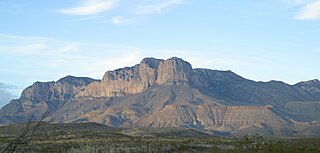
The Guadalupe Mountains are a mountain range located in West Texas and southeastern New Mexico. The range includes the highest summit in Texas, Guadalupe Peak, 8,751 ft (2,667 m), and the "signature peak" of West Texas, El Capitan, both of which are located within Guadalupe Mountains National Park. The Guadalupe Mountains are bordered by the Pecos River valley and Llano Estacado to the east and north, Delaware Mountains to the south, and Sacramento Mountains to the west. One of the clearest exposures of a prehistoric reef is preserved in the mountain range's bedrock geology. Bedrock contains fossils of reef-dwelling organisms from the Permian period, and the geology is widely studied, mostly by stratigraphers, paleontologists, and Paleoecologists.
Mescalero-Chiricahua is a Southern Athabaskan language spoken by the Chiricahua and Mescalero people in Chihuahua and Sonora, México and in Oklahoma and New Mexico. It is related to Navajo and Western Apache and has been described in great detail by the anthropological linguist Harry Hoijer (1904–1976), especially in Hoijer & Opler (1938) and Hoijer (1946). Hoijer & Opler's Chiricahua and Mescalero Apache Texts, including a grammatical sketch and traditional religious and secular stories, has been converted into an online "book" available from the University of Virginia.

The Mescalero Ridge forms the western edge of the great Llano Estacado, a vast plateau or tableland in the southwestern United States in New Mexico and Texas. It is the western equivalent of the Caprock Escarpment, which defines the eastern edge of the Llano Estacado.
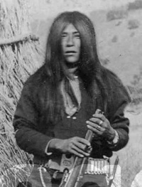
Massai was a member of the Mimbres/Mimbreños local group of the Chihenne band of the Chiricahua Apache. He was a warrior who was captured but escaped from a train that was sending the scouts and renegades to Florida to be held with Geronimo and Chihuahua.
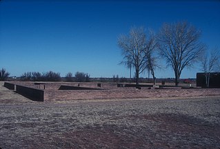
Fort Sumner was a military fort in New Mexico Territory charged with the internment of Navajo and Mescalero Apache populations from 1863 to 1868 at nearby Bosque Redondo.

The Sierra Blanca is an ultra-prominent range of volcanic mountains in Lincoln and Otero counties in the south-central part of the U.S. state of New Mexico. The range is about 40 miles (64 km) from north to south and 20 miles (32 km) wide.

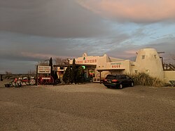
The Rio Ruidoso is a 30-mile (48 km) long river located in the Sierra Blanca and Sacramento Mountains in Lincoln County and Otero County, New Mexico in the United States and is part of the Rio Ruidoso Watershed. The Spanish term, río ruidoso, translated into English means literally "noisy river".

The Apache Scouts were part of the United States Army Indian Scouts. Most of their service was during the Apache Wars, between 1849 and 1886, though the last scout retired in 1947. The Apache scouts were the eyes and ears of the United States military and sometimes the cultural translators for the various Apache bands and the Americans. Apache scouts also served in the Navajo War, the Yavapai War, the Mexican Border War and they saw stateside duty during World War II. There has been a great deal written about Apache scouts, both as part of United States Army reports from the field and more colorful accounts written after the events by non-Apaches in newspapers and books. Men such as Al Sieber and Tom Horn were sometimes the commanding officers of small groups of Apache Scouts. As was the custom in the United States military, scouts were generally enlisted with Anglo nicknames or single names. Many Apache Scouts received citations for bravery.
Sara Jane Misquez was an American Mescalero Apache Native American leader. Misquez served as the president of the Mescalero Apache of southern New Mexico.
Mescalero Apache Tribe v. Jones, 411 U.S. 145 (1973), was a case in which the Supreme Court of the United States held that a state could tax tribal, off-reservation business activities but could not impose a tax on tribal land, which was exempt from all forms of property taxes.
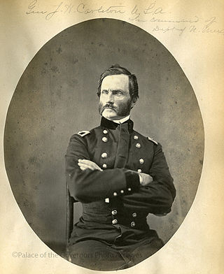
James Henry Carleton was an officer in the US Army and a Union general during the American Civil War. Carleton is best known as an Indian fighter in the Southwestern United States.
Virginia Shanta Klinekole, born Virginia Shanta, was a Mescalero Apache politician from New Mexico. She was elected as the first woman president of the Mescalero Apache Tribe, and served on the Tribal Council for nearly 30 years. She was known for being the first elected female leader of a major tribe, and for her work in preserving the Apache language.