Otero County | |
---|---|
Coordinates: 32°37′N105°44′W / 32.62°N 105.73°W | |
Country | United States |
State | New Mexico |
Founded | January 30, 1899 |
Named for | Miguel Antonio Otero |
Seat | Alamogordo |
Largest city | Alamogordo |
Area | |
• Total | 6,628 sq mi (17,170 km2) |
• Land | 6,613 sq mi (17,130 km2) |
• Water | 14 sq mi (40 km2) 0.2% |
Population (2020) | |
• Total | 67,839 |
• Density | 10/sq mi (4.0/km2) |
Time zone | UTC−7 (Mountain) |
• Summer (DST) | UTC−6 (MDT) |
Congressional district | 2nd |
Website | co |
Otero County (Spanish: Condado de Otero) is a county located in the U.S. state of New Mexico. As of the 2020 census, the population was 67,839. [1] Its county seat is Alamogordo. [2] Its southern boundary is the Texas state line. It is named for Miguel Antonio Otero, the territorial governor when the county was created. [3]
Otero County includes the Alamogordo Micropolitan Statistical Area. [4]
The western part of Otero County was handed over to the United States Army as the US was preparing to enter World War II and eventually became part of White Sands Missile Range. This did not significantly hinder the growth of the county, whose population more than doubled in the 1950s.[ citation needed ]
The county declared a state of emergency in April 2019 when the federal inspection stations on U.S. Route 70 and U.S. Route 54 were left unstaffed by U.S. Customs and Border Protection as part of the temporary closure of all six checkpoints in the El Paso Sector, which covers West Texas and New Mexico. The county was concerned about the possibility of illegal narcotics flowing north unchecked since the checkpoint agents had been shifted to the border to help process migrant asylum-seekers. [5] The inspection stations reopened August 5, 2019.
On Monday June 13, 2022, the county commissioners attracted nationwide attention by refusing to certify the results of the local 2022 primary election on June 7, 2022. [6] In response, the New Mexico Secretary of State filed a lawsuit and writ of mandamus against the commissioners for their refusal. By Friday June 17, 2022, two of the three commissioners agreed to certify the election results, which defused the crisis. [7]
According to the U.S. Census Bureau, the county has a total area of 6,628 square miles (17,170 km2), of which 6,613 square miles (17,130 km2) is land and 14 square miles (36 km2) (0.2%) is water. [8] It is the third-largest county in New Mexico by area.
Census | Pop. | Note | %± |
---|---|---|---|
1910 | 7,069 | — | |
1920 | 7,902 | 11.8% | |
1930 | 9,779 | 23.8% | |
1940 | 10,522 | 7.6% | |
1950 | 14,909 | 41.7% | |
1960 | 36,976 | 148.0% | |
1970 | 41,097 | 11.1% | |
1980 | 44,665 | 8.7% | |
1990 | 51,928 | 16.3% | |
2000 | 62,298 | 20.0% | |
2010 | 63,797 | 2.4% | |
2020 | 67,839 | 6.3% | |
U.S. Decennial Census [9] 1790-1960 [10] 1900-1990 [11] 1990-2000 [12] 2010 [13] |
As of the 2000 census, [14] there were 62,298 people, 22,984 households, and 16,801 families living in the county. The population density was 9 people per square mile (3.5 people/km2). There were 29,272 housing units at an average density of 4 per square mile (1.5/km2). The racial makeup of the county was 71.73% White, 3.92% Black or African American, 5.80% Native American, 1.17% Asian, 0.13% Pacific Islander, 11.67% from other races, and 3.60% from two or more races. 32.16% of the population were Hispanic or Latino of any race.
There were 22,984 households, out of which 37.10% had children under the age of 18 living with them, 57.50% were married couples living together, 11.80% had a female householder with no husband present, and 26.90% were non-families. 23.30% of all households were made up of individuals, and 8.10% had someone living alone who was 65 years of age or older. The average household size was 2.66 and the average family size was 3.14.
In the county, the population was spread out, with 29.50% under the age of 18, 9.30% from 18 to 24, 28.60% from 25 to 44, 21.00% from 45 to 64, and 11.70% who were 65 years of age or older. The median age was 34 years. For every 100 females there were 99.00 males. For every 100 females age 18 and over, there were 96.80 males.
The median income for a household in the county was $30,861, and the median income for a family was $34,781. Males had a median income of $27,657 versus $18,470 for females. The per capita income for the county was $14,345. About 15.60% of families and 19.30% of the population were below the poverty line, including 27.90% of those under age 18 and 12.80% of those age 65 or over.
As of the 2010 census, there were 63,797 people, 24,464 households, and 16,641 families living in the county. [15] The population density was 9.6 inhabitants per square mile (3.7/km2). There were 30,992 housing units at an average density of 4.7 per square mile (1.8/km2). [16] The racial makeup of the county was 70.7% white, 6.7% American Indian, 3.5% black or African American, 1.2% Asian, 0.2% Pacific islander, 11.5% from other races, and 4.2% from two or more races. Those of Hispanic or Latino origin made up 34.5% of the population. [15] In terms of ancestry, 13.4% were German, 8.1% were English, 8.0% were Irish, and 4.4% were American. [17]
Of the 24,464 households, 33.3% had children under the age of 18 living with them, 50.2% were married couples living together, 12.7% had a female householder with no husband present, 32.0% were non-families, and 27.1% of all households were made up of individuals. The average household size was 2.51 and the average family size was 3.05. The median age was 36.5 years. [15]
The median income for a household in the county was $39,615 and the median income for a family was $46,210. Males had a median income of $32,939 versus $25,965 for females. The per capita income for the county was $19,255. About 15.2% of families and 20.0% of the population were below the poverty line, including 28.0% of those under age 18 and 13.5% of those age 65 or over. [18]
School districts in the county include: [19]
While the southeast portion of the county is in the Alamogordo district, that district contracts education of residents there to the Dell City Independent School District of Dell City, Texas, [20] due to the distances involved, as the mileage to Alamogordo from the former Cienega School was 100 miles (160 km) while the distance to Dell City is 20 miles (32 km). [21]
Tribal schools affiliated with the Bureau of Indian Education (BIE):
State-operated schools:
Schools operated by foreign governments:
Tertiary:
Public libraries:
Governance of the county is under a three-member county commission. [22]
This article appears to be slanted towards recent events.(May 2024) |
In early 2021, Commissioner Couy Griffin, [23] a former street preacher, [24] was banned from entering the sizable Mescalero Apache Reservation in his own jurisdiction, [25] because he participated in the January 6 United States Capitol attack. On January 19, the other two commissioners called for his resignation. [25]
In a bench trial on March 21, 2022, Griffin was convicted of trespassing, but acquitted on the more serious charge of disorderly conduct. [26] In 2022, the county commission refused to certify primary election results. [27] After a court order from the New Mexico state Supreme Court, the commission eventually did certify the election results, but Commissioner Griffin continued with his refusal, voting "No". Commissioner Griffin justified his refusal by saying, "My vote to just remain a no isn't based on any evidence. It's not based on any facts, it's only based on my gut feeling and my own intuition, and that's all I need". [28]
On September 6, 2022, Griffin became the first public official in more than a century to be debarred from office under the Fourteenth Amendment to the United States Constitution. [29] The debarment from holding public office is "for life".
Stephanie Dubois, the Democratic candidate for Otero County District 2 Commission, was appointed by Governor Michelle Lynn Lujan Grisham and sworn in October 28, 2022. Dubois was facing Republican Amy Barela and the appointment took place in the final weeks of the election to replace Couy Griffin for the District 2, Otero County, New Mexico Commission Seat. The County leans heavily Republican. [30] [31] Barela won the November general election. [32]
Year | Republican | Democratic | Third party | |||
---|---|---|---|---|---|---|
No. | % | No. | % | No. | % | |
2020 | 14,521 | 61.61% | 8,485 | 36.00% | 565 | 2.40% |
2016 | 11,887 | 59.26% | 6,124 | 30.53% | 2,049 | 10.21% |
2012 | 12,451 | 62.22% | 6,829 | 34.12% | 732 | 3.66% |
2008 | 12,806 | 58.83% | 8,610 | 39.56% | 350 | 1.61% |
2004 | 14,066 | 67.74% | 6,433 | 30.98% | 265 | 1.28% |
2000 | 10,258 | 63.31% | 5,465 | 33.73% | 481 | 2.97% |
1996 | 9,065 | 55.49% | 5,938 | 36.35% | 1,334 | 8.17% |
1992 | 7,481 | 46.17% | 5,377 | 33.19% | 3,345 | 20.64% |
1988 | 9,984 | 64.50% | 5,284 | 34.14% | 210 | 1.36% |
1984 | 9,751 | 69.22% | 4,167 | 29.58% | 169 | 1.20% |
1980 | 7,210 | 60.26% | 4,111 | 34.36% | 644 | 5.38% |
1976 | 5,914 | 52.10% | 5,333 | 46.98% | 105 | 0.92% |
1972 | 7,033 | 65.91% | 2,981 | 27.94% | 656 | 6.15% |
1968 | 4,475 | 43.77% | 3,978 | 38.91% | 1,771 | 17.32% |
1964 | 3,498 | 36.59% | 6,035 | 63.13% | 27 | 0.28% |
1960 | 4,507 | 47.81% | 4,916 | 52.15% | 3 | 0.03% |
1956 | 3,919 | 60.45% | 2,558 | 39.46% | 6 | 0.09% |
1952 | 2,456 | 53.16% | 2,162 | 46.80% | 2 | 0.04% |
1948 | 1,354 | 36.27% | 2,361 | 63.25% | 18 | 0.48% |
1944 | 1,467 | 43.63% | 1,892 | 56.28% | 3 | 0.09% |
1940 | 1,596 | 47.09% | 1,788 | 52.76% | 5 | 0.15% |
1936 | 1,333 | 39.73% | 1,989 | 59.28% | 33 | 0.98% |
1932 | 969 | 30.99% | 2,091 | 66.87% | 67 | 2.14% |
1928 | 1,250 | 51.91% | 1,148 | 47.67% | 10 | 0.42% |
1924 | 832 | 41.17% | 886 | 43.84% | 303 | 14.99% |
1920 | 1,229 | 51.36% | 1,095 | 45.76% | 69 | 2.88% |
1916 | 561 | 37.03% | 824 | 54.39% | 130 | 8.58% |
1912 | 220 | 21.87% | 420 | 41.75% | 366 | 36.38% |
Hudspeth County is a county located in the U.S. state of Texas. As of the 2020 census, the population was 3,202. Its county seat is Sierra Blanca, and the largest community is Fort Hancock. The county is named for Claude Benton Hudspeth, a state senator and United States Representative from El Paso. It is northeast of the Mexico–U.S. border.
Torrance County is a county located in the center of the U.S. state of New Mexico. As of the 2020 census, the population was 15,045. The county seat is Estancia.
Sierra County is a county located in the U.S. state of New Mexico. As of the 2020 Census, the population was 11,576. Its county seat is Truth or Consequences.
Roosevelt County is a county located in the U.S. state of New Mexico. As of the 2020 census, the population was 19,191. Its county seat is Portales. The county was created in 1903 from Chaves and Guadalupe counties and named for the then-current President of the United States, Theodore Roosevelt. The county's eastern border is the Texas state line.
Rio Arriba County is a county in the U.S. state of New Mexico. As of the 2020 census, the population was 40,363. Its county seat is Tierra Amarilla. Its northern border is the Colorado state line.
Lincoln County is a county in the U.S. state of New Mexico. As of the 2020 census, the population was 20,269. Its county seat is Carrizozo, while its largest community is Ruidoso.
Eddy County is a county located in the U.S. state of New Mexico. As of the 2020 census, the population was 62,314. Its county seat and largest city is Carlsbad. The county was created in 1891 and later organized in 1892. It is north of the Texas state line.
Chaparral is an unincorporated community and census-designated place (CDP) in Doña Ana and Otero counties, New Mexico. The population was 14,631 at the 2010 census. Chaparral is primarily a bedroom community for the neighboring city of El Paso, Texas, and the neighboring military installations of White Sands Missile Range and Fort Bliss. It is officially part of the Las Cruces Metropolitan Statistical Area.
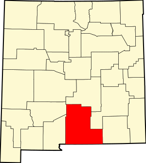
Alamogordo is the county seat of Otero County, New Mexico, United States. A city in the Tularosa Basin of the Chihuahuan Desert, it is bordered on the east by the Sacramento Mountains and to the west by Holloman Air Force Base. The population was 31,384 as of the 2020 census. Alamogordo is widely known for its connection with the 1945 Trinity test, which was the first ever explosion of an atomic bomb.
Boles Acres is a census-designated place (CDP) in Otero County, New Mexico, United States. The population was 1,638 at the 2010 census.
Cloudcroft is a village in Otero County, New Mexico, United States, and is located within the Lincoln National Forest. The population was 750 at the 2020 census.
La Luz is a census-designated place (CDP) in Otero County, New Mexico, United States. The population was 1,615 at the 2000 census. It is located immediately north of Alamogordo and lies in the eastern edge of the Tularosa Basin and on the western flank of the Sacramento Mountains. Until 1848, La Luz was a part of Mexico. The CDP gets its name from the Spanish word for "light."
Mescalero is a census-designated place (CDP) in Otero County, New Mexico, United States, located on the Mescalero Apache Reservation. The population was 1,338 at the 2010 census.
Timberon is a census-designated place (CDP) in Otero County, New Mexico, United States, and is within the Sacramento Mountains at the southern edge of the Lincoln National Forest. The population was 345 at the 2020 census.
Tularosa is a village in Otero County, New Mexico, United States. It shares its name with the Tularosa Basin, in which the town is located. To the east, Tularosa is flanked by the western edge of the Sacramento Mountains. The population was 2,553 at the 2020 census. During the 1990s and early 2000s, the town, north of the much larger Alamogordo, experienced moderate growth and construction as a bedroom community, especially in the housing industry. Tularosa is noted for its abundance of cottonwood shade trees and its efforts to preserve the adobe-style architecture of its past.
Dell City Independent School District (DCISD) is a public school district based in Dell City, Texas (USA). The district operates Dell City School, which covers grades Kindergarten through 12 and serves students in northern Hudspeth County. Dell City School is classified as a 1A school by the UIL. In 2016, the school was rated "Improvement Required" by the Texas Education Agency. In addition to northern Hudspeth County, it also serves areas of southeast Otero County, New Mexico as part of an inter-district agreement with Alamogordo Public Schools due to the area's lack of proximity to the Alamogordo district's schools.
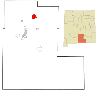
Orogrande is an unincorporated community in Otero County, New Mexico, United States, located at a latitude of 32.37111 and a longitude of -106.08389 in the Jarilla Mountains of the Tularosa Basin on U.S. 54 between El Paso, Texas and Alamogordo. Originally a mining town named Jarilla Junction due to its proximity to the Jarilla Mountains, established in 1905, the town was renamed Orogrande in 1906 and is not far from similar mining towns named Brice and Ohaysi. The population soared to approximately 2000 as the result of a gold rush that occurred in 1905, but quickly collapsed almost to the point of depopulation when the gold deposits proved much less abundant than expected. There are still numerous abandoned mines in the area which fall under the jurisdiction of the Bureau of Land Management. Other land around Orogrande is part of a military reservation under the control of Fort Bliss.
Doña Ana County is located in the southern part of the State of New Mexico, United States. As of the 2020 U.S. Census, its population was 219,561, which makes it the second-most populated county in New Mexico. Its county seat is Las Cruces, the second-most populous municipality in New Mexico after Albuquerque, with 111,385 as of the 2020 U.S. Census.
Mescalero Apache Schools (MAS), also known as Mescalero Apache School, is a tribal K-12 school in unincorporated Otero County, New Mexico, associated with the Bureau of Indian Education (BIE). It is of the Mescalero Apache tribe.
Couy Dale Griffin is an American former politician who served from 2019 to 2022 as a county commissioner for District 2 of Otero County, New Mexico, which covers Tularosa, Three Rivers, La Luz, the western parts of Alamogordo, and the Mescalero Apache Reservation. In September 2022, Griffin was removed from office pursuant to the Insurrection Clause of the Fourteenth Amendment to the United States Constitution due to his actions in the January 6 United States Capitol attack. He is a member of the Republican Party.
Dell City Purchase Requisition 20210058 - $34,063.12 for out of state tuition for students residing in the southeast corner of Otero County, NM that attend Dell City, TX ISD