Curry County, New Mexico

Last updated

Curry County
Curry County NM Courthouse.jpg
Curry County Courthouse in Clovis
Flag of Curry County, New Mexico.gif
Map of New Mexico highlighting Curry County.svg
Location within the U.S. state of New Mexico
New Mexico in United States.svg
New Mexico's location within the U.S.
Coordinates: 34°34′N103°21′W / 34.57°N 103.35°W / 34.57; -103.35
CountryFlag of the United States.svg United States
StateFlag of New Mexico.svg  New Mexico
FoundedFebruary 25, 1909
Named for George Curry
Seat Clovis
Largest cityClovis
Area
  Total1,408 sq mi (3,650 km2)
  Land1,405 sq mi (3,640 km2)
  Water3.2 sq mi (8 km2)  0.2%
Population
 (2020)
  Total48,430
  Density34.5/sq mi (13.3/km2)
Time zone UTC−7 (Mountain)
  Summer (DST) UTC−6 (MDT)
Congressional district 3rd
Website www.currycounty.org

Curry County is a county located in the U.S. state of New Mexico. As of the 2020 census, its population was 48,430. [1] Its county seat is Clovis. [2] The county is named in honor of George Curry, territorial governor of New Mexico from 1907 to 1910.

Contents

Curry County comprises the Clovis, New Mexico micropolitan statistical area, which is also included in the Clovis–Portales combined statistical area. It is located on the far eastern state line, adjacent to Texas, forming part of the region of Eastern New Mexico.

Geography

According to the U.S. Census Bureau, the county has a total area of 1,408 sq mi (3,650 km2), of which 1,405 square miles (3,640 km2) are land and 3.2 sq mi (8.3 km2) (0.2%) are covered by water. [3] It is the fourth-smallest county in New Mexico by area.

Adjacent counties

Demographics

Historical population
CensusPop.Note
1910 11,443
1920 11,236−1.8%
1930 15,80940.7%
1940 18,15914.9%
1950 23,35128.6%
1960 32,69140.0%
1970 39,51720.9%
1980 42,0196.3%
1990 42,2070.4%
2000 45,0446.7%
2010 48,3767.4%
2020 48,4300.1%
U.S. Decennial Census [4]
1790-1960 [5] 1900-1990 [6]
1990-2000 [7] 2010 [8]

2010 census

As of the 2010 census, 48,376 people, 18,015 households, and 12,341 families were living in the county. [9] The population density was 34.4 inhabitants per square mile (13.3/km2). The 20,062 housing units averaged 14.3/sq mi (5.5/km2). [10] The racial makeup of the county was 69.7% white, 6.3% African American, 1.3% Asian, 1.2% American Indian, 0.1% Pacific Islander, 17.2% from other races, and 4.1% from two or more races. Those of Hispanic or Latino origin made up 39.5% of the population. [9] In terms of ancestry, 11.2% were German, 11.0% were American, 8.0% were Irish, and 6.7% were English. [11]

Of the 18,015 households, 37.8% had children under the age of 18 living with them, 49.0% were married couples living together, 14.2% had a female householder with no husband present, 31.5% were not families, and 26.4% of all households were made up of individuals. The average household size was 2.63, and the average family size was 3.18. The median age was 31.5 years. [9]

The median income for a household in the county was $38,090 and for a family was $48,933. Males had a median income of $35,743 versus $26,585 for females. The per capita income for the county was $19,925. About 15.5% of families and 20.1% of the population were below the poverty line, including 28.9% of those under age 18 and 13.5% of those age 65 or over. [12]

2000 census

As of the 2000 census, [13] 45,044 people, 16,766 households, and 11,870 families were living in the county. The population density was 32 people/sq mi (12 people/km2). The 19,212 housing units averaged 14 units per square mile (5.4/km2). The racial makeup of the county was 72.40% White, 6.86% African American, 1.00% Native American, 1.78% Asian, 0.13% Pacific Islander, 14.08% from other races, and 3.75% from two or more races. About 30.38% of the population were Hispanic or Latino of any race.

Of the 16,766 households, 38.00% had children under the age of 18 living with them, 54.00% were married couples living together, 12.80% had a female householder with no husband present, and 29.20% were not families. About 25.50% of all households were made up of individuals, and 9.00% had someone living alone who was 65 years of age or older. The average household size was 2.62, and the average family size was 3.15.

In the county, the age distribution was 30.10% under 18, 11.50% from 18 to 24, 28.80% from 25 to 44, 18.10% from 45 to 64, and 11.50% who were 65 or older. The median age was 31 years. For every 100 females, there were 97.60 males. For every 100 females age 18 and over, there were 94.30 males.

The median income for a household in the county was $28,917, and for a family was $33,900. Males had a median income of $25,086 versus $19,523 for females. The per capita income for the county was $15,049. About 15.50% of families and 19.00% of the population were below the poverty line, including 25.10% of those under age 18 and 14.30% of those age 65 or over.

Communities

St. Vrain Post Office St. Vrain, New Mexico Post Office.jpg
St. Vrain Post Office
Bellview Post office Bellview New Mexico Post Office 2010.jpg
Bellview Post office
Grier grain elevator Grier New Mexico Grain Elevator 2011.jpg
Grier grain elevator

Cities

Villages

Census-designated place

Unincorporated communities

Politics

Like much of Eastern New Mexico, Curry County normally votes conservative, having not voted for a Democrat for President since 1964.

United States presidential election results for Curry County, New Mexico [14]
Year Republican Democratic Third party
No.%No.%No.%
2020 10,44469.16%4,30728.52%3502.32%
2016 9,03567.58%3,12123.34%1,2149.08%
2012 9,25167.90%4,02229.52%3522.58%
2008 9,59966.48%4,67032.35%1691.17%
2004 10,64974.54%3,54124.79%960.67%
2000 8,30169.35%3,47129.00%1971.65%
1996 7,37859.28%4,11633.07%9537.66%
1992 6,83154.07%3,69929.28%2,10316.65%
1988 8,03266.17%3,99532.91%1110.91%
1984 9,18874.01%3,10825.03%1190.96%
1980 8,13267.37%3,62230.01%3162.62%
1976 6,23254.87%5,00444.06%1221.07%
1972 8,39275.85%2,41621.84%2562.31%
1968 5,56253.99%2,91528.30%1,82517.72%
1964 5,12049.34%5,22850.38%300.29%
1960 6,15363.83%3,42135.49%650.67%
1956 4,82657.27%3,54542.07%560.66%
1952 5,02359.38%3,42240.45%140.17%
1948 2,13226.85%5,75972.52%500.63%
1944 2,32641.47%3,27158.32%120.21%
1940 1,62925.78%4,67073.90%200.32%
1936 1,02317.65%4,68980.89%851.47%
1932 93218.35%3,73873.60%4098.05%
1928 1,96856.16%1,53043.66%60.17%
1924 66920.55%1,73853.39%84826.05%
1920 88427.81%2,14367.41%1524.78%
1916 35519.14%1,17563.34%32517.52%
1912 12310.22%63452.66%44737.13%

Education

School districts include: [15]

See also

Related Research Articles

<span class="mw-page-title-main">Curry County, Oregon</span> County in Oregon, United States

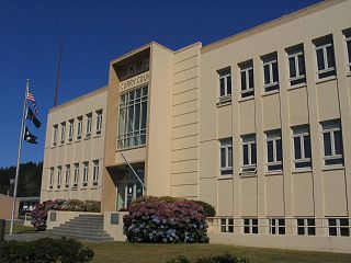
Curry County is the southwesternmost county in the U.S. state of Oregon located on the South Coast. As of the 2020 census, the population was 23,446. The county seat is Gold Beach. The county is named for George Law Curry, a two-time governor of the Oregon Territory. Curry County includes the Brookings, OR Micropolitan Statistical Area.

<span class="mw-page-title-main">Sandoval County, New Mexico</span> County in New Mexico, United States

Sandoval County is located in the U.S. state of New Mexico. As of the 2020 census, the population was 148,834, making it the fourth-most populous county in New Mexico. The county seat is Bernalillo.

<span class="mw-page-title-main">Roosevelt County, New Mexico</span> County in New Mexico, United States

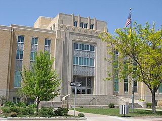
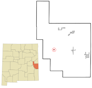
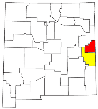
Roosevelt County is a county located in the U.S. state of New Mexico. As of the 2020 census, the population was 19,191. Its county seat is Portales. The county was created in 1903 from Chaves and Guadalupe counties and named for the then-current President of the United States, Theodore Roosevelt. The county's eastern border is the Texas state line.

<span class="mw-page-title-main">Quay County, New Mexico</span> County in New Mexico, United States

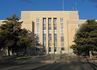
Quay County is a county in the state of New Mexico. As of the 2020 U.S. census, the population was 8,746. Its county seat is Tucumcari. The county was named for Pennsylvania senator Matthew Quay, who supported statehood for New Mexico. Its eastern border is the Texas state line, approximately 103.04 degrees west longitude.

<span class="mw-page-title-main">Luna County, New Mexico</span> County in New Mexico, United States

Luna County(Spanish: Condado de Luna) is a county located in the U.S. state of New Mexico. As of the 2020 census, the population was 25,427. Its county seat is Deming. This county abuts the Mexican border. Luna County comprises the Deming, NM Micropolitan Statistical Area.

<span class="mw-page-title-main">Hidalgo County, New Mexico</span> County in New Mexico, United States

Hidalgo County is the southernmost county of the U.S. state of New Mexico. As of the 2020 census, the population was 4,178. The county seat and largest city is Lordsburg. A bill creating Hidalgo from the southern part of Grant County was passed on February 25, 1919, taking effect at the beginning of 1920. The county was named for the town north of Mexico City where the Treaty of Guadalupe Hidalgo was signed, which in turn was named for Miguel Hidalgo y Costilla, the priest who is known as the "Father of Mexican Independence." The county is located on the Mexico–United States border.

<span class="mw-page-title-main">Guadalupe County, New Mexico</span> County in New Mexico, United States

Guadalupe County is a county in the U.S. state of New Mexico. As of the 2020 census, the population was 4,452. Its county seat is Santa Rosa.

<span class="mw-page-title-main">Colfax County, New Mexico</span> County in New Mexico, United States

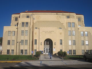
Colfax County is a county in the U.S. state of New Mexico. As of the 2020 census, the population was 12,387. Its county seat is Raton. It is south from the Colorado state line. This county was named for Schuyler Colfax (1823–1885), seventeenth Vice President of the United States under U.S. President Ulysses S. Grant.

<span class="mw-page-title-main">Murdock, Nebraska</span> Village in Nebraska, United States

Murdock is a village in Cass County, Nebraska, United States. The population was 270 according to the 2020 census.

<span class="mw-page-title-main">Encinal, New Mexico</span> Census-designated place in New Mexico, United States

Encinal is a census-designated place (CDP) in Cibola County, New Mexico, United States. It is the smallest of the six villages of the Laguna Pueblo and sits at the base of Mount Taylor. The population was 210 at the 2010 census. The feast day for Encinal is September 8.

<span class="mw-page-title-main">Clovis, New Mexico</span> City in the United States

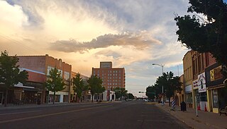
Clovis is a city in and the county seat of Curry County, New Mexico. The city had a population of 37,775 as of the 2010 census, and a 2020 census population of 38,567. Clovis is located in the New Mexico portion of the Llano Estacado, in the eastern part of the state.

<span class="mw-page-title-main">Melrose, New Mexico</span> Village in New Mexico, United States

Melrose is a village in Curry County, New Mexico, United States. Its population was 651 at the 2010 census. The town is losing population due to rural exodus. Melrose is served by Melrose Elementary School and Melrose High School.

<span class="mw-page-title-main">Texico, New Mexico</span> City in New Mexico, United States

Texico is a city in Curry County, New Mexico, United States. Its population was 1,130 at the 2010 census. The city is located on the Texas-New Mexico border with the town of Farwell across the border.

<span class="mw-page-title-main">Elida, New Mexico</span> Town in New Mexico, United States

Elida is a town in Roosevelt County, New Mexico, United States. The population was 197 at the 2010 census.

<span class="mw-page-title-main">Portales, New Mexico</span> City in New Mexico, United States

Portales is a city in and the county seat of Roosevelt County, New Mexico, United States. Its population was 12,280 at the 2010 census. Portales is located near the larger city of Clovis, and Cannon Air Force Base, a major contributor to the economy of the region.

<span class="mw-page-title-main">Pine Township, Mercer County, Pennsylvania</span> Township in Pennsylvania, United States

Pine Township is a township in Mercer County, Pennsylvania, United States. The population was 4,808 at the 2020 census, down from 5,150 in 2010.

<span class="mw-page-title-main">Washington Township, Snyder County, Pennsylvania</span> Township in Pennsylvania, United States

Washington Township is a township in Snyder County, Pennsylvania, United States. The population was 1,759 at the 2020 census.

<span class="mw-page-title-main">Farwell, Texas</span> City in Texas, United States

Farwell is a city in and the county seat of Parmer County, Texas, United States. Its population was 1,363 at the 2010 census. The city is located on the Texas-New Mexico border with the city of Texico, New Mexico across the border.

<span class="mw-page-title-main">Clovis-Portales CSA</span>

The Clovis-Portales Combined Statistical Area is made up of two counties in east central New Mexico. The statistical area consists of the Clovis Micropolitan Statistical Area and the Portales Micropolitan Statistical Area. As of the 2000 census, the CSA had a population of 63,062.

<span class="mw-page-title-main">De Baca County, New Mexico</span> County in New Mexico, United States

De Baca County is a county in the U.S. state of New Mexico. As of the 2020 census, the population was 1,698, making it New Mexico's second-least populous county. Its county seat is Fort Sumner. The county is named for Ezequiel Cabeza De Baca, the second elected Governor of New Mexico.

References

  1. "Curry County, New Mexico". United States Census Bureau . Retrieved July 1, 2023.
  2. "Find a County". National Association of Counties. Archived from the original on May 31, 2011. Retrieved June 7, 2011.
  3. "2010 Census Gazetteer Files". United States Census Bureau. August 22, 2012. Archived from the original on January 1, 2015. Retrieved January 1, 2015.
  4. "U.S. Decennial Census". United States Census Bureau. Retrieved January 1, 2015.
  5. "Historical Census Browser". University of Virginia Library. Archived from the original on August 11, 2012. Retrieved January 1, 2015.
  6. "Population of Counties by Decennial Census: 1900 to 1990". United States Census Bureau. Retrieved January 1, 2015.
  7. "Census 2000 PHC-T-4. Ranking Tables for Counties: 1990 and 2000" (PDF). United States Census Bureau. Archived (PDF) from the original on March 27, 2010. Retrieved January 1, 2015.
  8. "State & County QuickFacts". United States Census Bureau. Archived from the original on June 6, 2011. Retrieved September 27, 2013.
  9. 1 2 3 "DP-1 Profile of General Population and Housing Characteristics: 2010 Demographic Profile Data". United States Census Bureau. Archived from the original on February 13, 2020. Retrieved January 24, 2016.
  10. "Population, Housing Units, Area, and Density: 2010 - County". United States Census Bureau. Archived from the original on February 13, 2020. Retrieved January 24, 2016.
  11. "DP02 SELECTED SOCIAL CHARACTERISTICS IN THE UNITED STATES – 2006-2010 American Community Survey 5-Year Estimates". United States Census Bureau. Archived from the original on February 13, 2020. Retrieved January 24, 2016.
  12. "DP03 SELECTED ECONOMIC CHARACTERISTICS – 2006-2010 American Community Survey 5-Year Estimates". United States Census Bureau. Archived from the original on February 13, 2020. Retrieved January 24, 2016.
  13. "U.S. Census website". United States Census Bureau . Retrieved January 31, 2008.
  14. Leip, David. "Dave Leip's Atlas of U.S. Presidential Elections". uselectionatlas.org. Retrieved April 1, 2018.
  15. "2020 CENSUS - SCHOOL DISTRICT REFERENCE MAP: Curry County, NM" (PDF). U.S. Census Bureau. Archived (PDF) from the original on July 13, 2022. Retrieved July 12, 2022. - Text list

34°34′N103°21′W / 34.57°N 103.35°W / 34.57; -103.35