
Oxbow is an unincorporated community in Baker County, Oregon, United States. Oxbow is along Oregon Route 86 next to the Snake River near the Oxbow Dam on the Oregon-Idaho border, about 17 miles (27 km) northeast of Halfway. Oxbow is just south of the site of the former mining town of Copperfield. Oxbow has a post office with a ZIP code 97840.
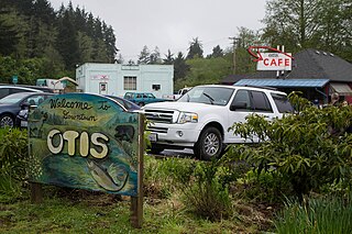
Otis is an unincorporated community in Lincoln County, Oregon, United States, a half mile north of Otis Junction on Oregon Route 18. It is near the Salmon River.

Camp Sherman is an unincorporated community and census-designated place (CDP) in Jefferson County, Oregon, United States. It is located on the Metolius River. The year-round population as of the 2010 census was 233, with that number tripling or more during the summer. The community includes an elementary school, Black Butte School, a general store and a post office. The community also has a volunteer fire department. Camp Sherman was founded by vacationers from Sherman County in the latter part of the 19th century.

Belknap Springs is an unincorporated community and private hot springs resort in Lane County, Oregon, United States, near the McKenzie River. The springs were located and initially developed by R. S. Belknap in 1869. A post office named "Salt Springs" was established in the location in 1874, and the name changed to "Belknap Springs" in 1875. The post office closed in 1877 and reopened in 1891, operating intermittently until 1953. Today the location uses a McKenzie Bridge mailing address.

Powell Butte is an unincorporated community in Crook County, Oregon, United States, and named after the nearby Powell Buttes. It is on Oregon Route 126 west of Prineville and east of Redmond. Powell Butte post office was established in 1909.

Blodgett is a census-designated place (CDP) and unincorporated community in Benton County, Oregon, United States, where Oregon Route 180 meets U.S. Route 20 in the Central Oregon Coast Range 15 miles (24 km) west of Corvallis. It is near the confluence of the Tumtum and Marys rivers. As of the 2010 census, the community had a population of 58.

Kent is an unincorporated community in Sherman County, Oregon, United States. Kent has a post office with a ZIP code 97033. Kent lies at the intersection of U.S. Route 97 and Dobie Point Road, between Grass Valley to the north and Shaniko to the south.
Hereford is an unincorporated community in Baker County, in the U.S. state of Oregon. Hereford lies along the Burnt River southwest of Baker. It is on Oregon Route 245 northeast of its intersection with U.S. Route 26 in Unity. Hereford is 3,671 feet (1,119 m) above sea level.

Umapine (/uməpaɪn/) is a census-designated place and unincorporated community in Umatilla County, Oregon, United States, two miles from the Oregon-Washington border. The traditional boundary covers a wide area. It has a population of 315 people as of 2010. The community is part of the Pendleton–Hermiston Micropolitan Statistical Area. The current economy is supported by agriculture, including wheat and hay farms, apple orchards, and an increasing number of vineyards. The main establishments in the town are Tate's Umapine Market, The Umapine Creamery and the Waterhole Tavern.

Saint Benedict is the name of the post office at Mount Angel Abbey in Marion County, Oregon, United States.
Camas Valley is an unincorporated community in Douglas County, Oregon, United States, in the valley of the same name. It is on Oregon Route 42, near the Middle Fork Coquille River.

Curtin is an unincorporated community in Douglas County, Oregon, United States. It is on Interstate 5 and the former Southern Pacific railroad line about 7 miles (11 km) northeast of Drain along Pass Creek. It stands at an elevation of 404 feet.
Tenmile is an unincorporated community in Douglas County, Oregon, United States. It is located on Oregon Route 42 southwest of Roseburg.

Mohawk is an unincorporated community in Lane County, Oregon, United States, on the Mohawk River, about seven miles upstream from Springfield.
Broadbent is an unincorporated community in Coos County, Oregon, United States. Broadbent is on Oregon Route 542 south of Myrtle Point along the South Fork Coquille River. Broadbent has a post office with ZIP code 97414.

Ritter is an unincorporated community in Grant County, Oregon, United States, ten miles down the Middle Fork John Day River from U.S. Route 395, between Dale and Long Creek. At one time the locale was also known as Ritter Hot Springs.
Shaw is an unincorporated community in Marion County, Oregon, United States, on Oregon Route 214.
Macleay is an unincorporated community in Marion County, Oregon, United States, about nine miles east of downtown Salem in the Waldo Hills near the Little Pudding River.

Dale is an unincorporated community in Grant County, Oregon, United States. It is located on U.S. Route 395 within the Umatilla National Forest about 17 miles south of Ukiah. It is near the Umatilla-Grant County border just south of the 45th parallel north.
Rosedale is an unincorporated community in Marion County, Oregon. It is located just south of Salem in the Salem Hills. It is a part of the Salem Metropolitan Statistical Area. Rosedale post office ran from 1892 to 1901. The Rosedale area was a major prune growing region in the early 20th century but is now primarily made up of rural residential properties Vineyards and Christmas tree fields. Rosedale Elementary School located at 6974 Bates Road, Salem, Oregon was in service from 1893 until its closing in 2012. The town was located around the area of Sunnyside Road SE and Delany Road SE. It had a gas station, post office, grocery store, and a feed, seed and livery stable. The community still has a church and cemetery founded in 1896 located at 452 Hylo Rd SE.
