Tinkers Creek Aqueduct

Last updated

Tinkers Creek Aqueduct
Tctcaque.JPG
Coordinates 41°21′53.5″N81°36′31.7″W / 41.364861°N 81.608806°W / 41.364861; -81.608806
Elevation: 610 feet (190 m) [1]
Carries Ohio and Erie Canal
Crosses Tinkers Creek (Cuyahoga River)
LocaleCanal Road and
Tinkers Creek Road,
Valley View,
Cuyahoga County, Ohio
Maintained by National Park Service, Cuyahoga Valley National Park
Characteristics
MaterialWood deck and sides,
steel trusses over
Ashlar-sandstone piers
Total lengthOverall (including approaches): 90 feet (27 m) [2]
Each span: about 40 feet (12 m) [3]
WidthInterior: 22 feet (6.7 m) [4]
No. of spans2
Piers in water1
Load limit16,500 pounds (7,500 kg) per running 1 foot (0.30 m) [4]
Clearance above Unlimited [5]
Clearance below 0 feet (0 m)
History
Designer [3]
Construction start1826
Construction end1827
Re-built: 1845 and 1905 [6]
Opened1827 until
1913 flood
subsequent disuse
2007-? reconstruction project
Tinkers Creek Aqueduct
Figure79.jpg
Tinkers Creek Aqueduct [7] [8]
Location Valley View,
Cuyahoga County, Ohio
Arealess than one acre
Built1825-1827;
rebuilt 1845 and 1905
Part of Ohio and Erie Canal (ID66000607)
MPS Ohio and Erie Canal TR
NRHP reference No. 79000296 [9]
Significant dates
Added to NRHPDecember 11, 1979 [9]
Designated NHLDCPNovember 13, 1966 [10]
Location
Tinkers Creek Aqueduct

Tinkers Creek Aqueduct is an aqueduct that was constructed to bridge the Ohio and Erie Canal over Tinkers Creek near its confluence with the Cuyahoga River in Valley View, Ohio. It is a relatively rare surviving example of an Ohio and Erie Canal aqueduct. It was originally constructed in 1825-1827 by, and re-built due to flood damage in 1845 and 1905. [11] Tinkers Creek Aqueduct was included in a National Historic Landmark district established in 1966, and it was separately listed on the National Register of Historic Places in 1979. [12] [13] The original Tinkers Creek Aqueduct was a wood plank, steel truss, and Ashlar-sandstone structure constructed in 1827, south of the present aqueduct's location. Cuyahoga River and Tinkers Creek flooding caused continual damage to the original aqueduct, so successive structures were built in 1845 and 1905 in the present location. Today, Tinkers Creek Aqueduct is the only aqueduct which remains of the four original aqueducts in the Cuyahoga Valley. [6] Of Furnace Run Aqueduct, Mill Creek Aqueduct, Peninsula Aqueduct, and (? Yellow Creek ?) Aqueduct; Mill Creek Aqueduct, of newer construction, is the only aqueduct which still carries Ohio and Erie Canal water. After 102 years of flooding, weathering, and deterioration, Tinkers Creek Aqueduct was removed in 2007. The National Park Service is currently working on Phase II of the project to reconstruct it from newer materials. [10]

Contents

Statistics

Condition

The Tinkers Creek Aqueduct is a contributing structure on the NHL portion of the canal and continues to deteriorate rapidly. Due to the advanced state of decay, the aqueduct structure and the associated towpath Trial bridge will be removed and eventually replace with a newer aqueduct and bridge. Phase 1 of the project will involve removal of the existing aqueduct and Towpath Bridge, installation of a new Towpath Bridge, installation of temporary steel pipes to carry the canal water over the creek, restoration of portions of the sandstone abutment walls, and installation of a temporary high-water overflow structure. A later phase will include replacement of the aqueduct structure with a new design and restoration of the existing sandstone center pier and remaining abutment walls. Phase 1 is to begin in FY 2007. The increased numbers of flood events in recent years has caused significant damage to the river and stream banks which potentially threatens the canal basin. Ongoing monitoring and stabilization of river and stream banks will continue as needed. [14]

Flooding

The aqueduct and surrounding area are subject to flooding by the Cuyahoga River and Tinkers Creek. [15]

See also

Related Research Articles

<span class="mw-page-title-main">Erie Canal</span> Waterway in New York, U.S.

The Erie Canal is a historic canal in upstate New York that runs east–west between the Hudson River and Lake Erie. Completed in 1825, the canal was the first navigable waterway connecting the Atlantic Ocean to the Great Lakes, vastly reducing the costs of transporting people and goods across the Appalachians. In effect, the canal accelerated the settlement of the Great Lakes region, the westward expansion of the United States, and the economic ascendancy of New York State. It has been called "The Nation's First Superhighway."

<span class="mw-page-title-main">Chesapeake and Ohio Canal</span> Canal in Washington, D.C. and Maryland, United States

The Chesapeake and Ohio Canal, abbreviated as the C&O Canal and occasionally called the Grand Old Ditch, operated from 1831 until 1924 along the Potomac River between Washington, D.C., and Cumberland, Maryland. It replaced the Potomac Canal, which shut down completely in 1828, and could operate during months in which the water level was too low for the former canal. The canal's principal cargo was coal from the Allegheny Mountains.

<span class="mw-page-title-main">Cuyahoga Valley National Park</span> National park in Ohio, United States

Cuyahoga Valley National Park is an American national park that preserves and reclaims the rural landscape along the Cuyahoga River between Akron and Cleveland in Northeast Ohio.

<span class="mw-page-title-main">Miami and Erie Canal</span> 19th-century manmade water route between Cincinnati and Toledo, Ohio, U.S.

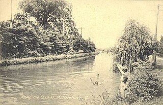
The Miami and Erie Canal was a 274-mile (441 km) canal that ran from Cincinnati to Toledo, Ohio, creating a water route between the Ohio River and Lake Erie. Construction on the canal began in 1825 and was completed in 1845 at a cost to the state government of $8,062,680.07. At its peak, it included 19 aqueducts, three guard locks, 103 canal locks, multiple feeder canals, and a few man-made water reservoirs. The canal climbed 395 feet (120 m) above Lake Erie and 513 feet (156 m) above the Ohio River to reach a topographical peak called the Loramie Summit, which extended 19 miles (31 km) between New Bremen, Ohio to lock 1-S in Lockington, north of Piqua, Ohio. Boats up to 80 feet long were towed along the canal by mules, horses, or oxen walking on a prepared towpath along the bank, at a rate of four to five miles per hour.

<span class="mw-page-title-main">Chesapeake and Ohio Canal National Historical Park</span> Historic site in Maryland and Washington, D.C.

The Chesapeake and Ohio Canal National Historical Park is located in the District of Columbia and the state of Maryland. The park was established in 1961 as a National Monument by President Dwight D. Eisenhower to preserve the neglected remains of the Chesapeake and Ohio Canal and many of its original structures.

<span class="mw-page-title-main">The Flats</span> Historic district in Cleveland, Ohio

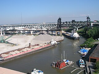
The Flats is a mixed-use industrial, recreational, entertainment, and residential area of the Cuyahoga Valley neighborhood of Cleveland, Ohio, U.S. The name reflects its low-lying topography on the banks of the Cuyahoga River.

<span class="mw-page-title-main">Ohio and Erie Canal</span> 19th-century manmade water route between Akron and Cleveland, Ohio, USA

The Ohio and Erie Canal was a canal constructed during the 1820s and early 1830s in Ohio. It connected Akron with the Cuyahoga River near its outlet on Lake Erie in Cleveland, and a few years later, with the Ohio River near Portsmouth. It also had connections to other canal systems in Pennsylvania.

<span class="mw-page-title-main">James River and Kanawha Canal</span> United States historic place

The James River and Kanawha Canal was a partially built canal in Virginia intended to facilitate shipments of passengers and freight by water between the western counties of Virginia and the coast. Ultimately its towpath became the roadbed for a rail line following the same course.

<span class="mw-page-title-main">Delaware and Hudson Canal</span> Former canal in New York and Pennsylvania, United States

The Delaware and Hudson Canal was the first venture of the Delaware and Hudson Canal Company, which would later build the Delaware and Hudson Railway. Between 1828 and 1899, the canal's barges carried anthracite coal from the mines of northeastern Pennsylvania to the Hudson River and thence to market in New York City.

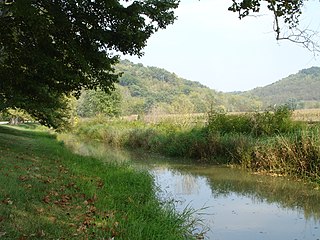
Tinker's Creek, in Cuyahoga, Summit and Portage counties, is the largest tributary of the Cuyahoga River, providing about a third of its flow into Lake Erie.

<span class="mw-page-title-main">Old Brooklyn</span> Neighborhood of Cleveland, Ohio, United States

Old Brooklyn is a neighborhood on the West Side of Cleveland, Ohio, United States, located approximately five miles south of downtown Cleveland. It extends east-to-west from the Cuyahoga River to the city of Brooklyn and north-to-south from the Brookside Park Valley to the city of Parma. It is home to the Cleveland Metroparks, including the Cleveland Zoo; the Jesse Owens tree at James Ford Rhodes High School; and the Benjamin Franklin Community Garden, the largest urban community garden in Cuyahoga County. Old Brooklyn has recently adopted the slogan "Old Brooklyn, a great place to grow" to commemorate its history and potential growth.

Summit Metro Parks is a Metroparks system serving the citizens of Summit County, Ohio by managing 14,000 acres (5,700 ha) in 16 developed parks, six conservation areas and more than 150 miles (240 km) of trails, with 22.4 miles (36.0 km) of the Ohio & Erie Canal Towpath Trail.

<span class="mw-page-title-main">National Register of Historic Places listings in Ohio</span>

This is a list of properties and districts in Ohio that are listed on the National Register of Historic Places. There are over 4.000 in total. Of these, 73 are National Historic Landmarks. There are listings in each of Ohio's 88 counties.

<span class="mw-page-title-main">Whitewater Canal</span> United States historic place

The Whitewater Canal, which was built between 1836 and 1847, spanned a distance of 76 miles (122 km) and stretched from Lawrenceburg, Indiana on the Ohio River to Hagerstown, Indiana near the West Fork of the White River.

<span class="mw-page-title-main">Schoharie Crossing State Historic Site</span> United States historic place

Schoharie Crossing State Historic Site, also known as Erie Canal National Historic Landmark, is a historic district that includes the ruins of the Erie Canal aqueduct over Schoharie Creek, and a 3.5-mile (5.6 km) long part of the Erie Canal, in the towns of Glen and Florida within Montgomery County, New York. It was the first part of the old canal to be designated a National Historic Landmark, prior to the designation of the entire New York State Barge Canal as an NHL in 2017.

<span class="mw-page-title-main">Cascade Locks Historic District</span> Historic district in Ohio, United States

The Cascade Locks Historic District is a historic district located in Akron, Ohio. It was added to the National Register of Historic Places in 1992.

<span class="mw-page-title-main">Seneca Aqueduct</span> United States historic place

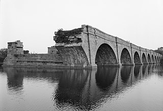
Seneca Aqueduct — or Aqueduct No. 1 — is a naviduct that carries the Chesapeake and Ohio Canal (C&O) over Seneca Creek in Montgomery County, Maryland. The C&O built eleven aqueducts along its 184.5 miles (296.9 km) length. Seneca Aqueduct is a unique structure, not only being the first built, but also the only red sandstone aqueduct on the C&O−and the only aqueduct that is also a lock. It is located at the end of Riley's Lock Road in Seneca, Maryland.

<span class="mw-page-title-main">Ohio and Erie Canal Towpath Trail</span> Multi-use trail in Northeast Ohio

The Ohio and Erie Canal Towpath Trail is a multi-use trail that follows part of the former route of the Ohio & Erie Canal in Northeast Ohio.

The Valley Railway was a shortline railroad which operated between the city of Cleveland and small town of Zoarville in the state of Ohio in the United States. The railroad was founded in 1871, but the first segment of track did not open until 1880 and the line was not completed until 1884. The Baltimore and Ohio Railroad (B&O) obtained a controlling interest in the Valley Railway in 1890. The railroad went bankrupt in 1895, at which time it was reorganized as The Cleveland Terminal and Valley Railroad Company (CT&V). The B&O took over operation of the CT&V in 1909, and the company was merged with the B&O in 1915.

References

  1. 1 2 U.S. Geological Survey Geographic Names Information System: Tinkers Creek Aqueduct
  2. "Towpath Trail bridge finished". Ohio.Com of Akron Beacon Journal.
  3. 1 2 1905 re-build engineers: C.E. Perkins, Columbus; T.D.P., Akron "Improvement of the Northern Division of the Ohio Canal (1905)". Cleveland Memory, Cleveland State University Libraries.
  4. 1 2 "Tinkers Creek Aqueduct drawing" (JPG). Cleveland Memory, Cleveland State University Libraries.
  5. Tinkers Creek Aqueduct on the Ohio and Erie Canal has no overhead structural members, so has unlimited overhead clearance; elsewhere along the Ohio and Erie Canal, other overhead bridges, overhead power lines and trees limit vertical clearance.
  6. 1 2 "Ohio & Erie Canal Towpath Trail Tour, Tinkers Creek Aqueduct". National Park Service, Cuyahoga Valley National Park. Archived from the original on June 3, 2008.
  7. "Historic Photograph of Tinkers Creek Aqueduct" (JPEG). National Park Service, Cuyahoga Valley National Park.
  8. "Cuyahoga Valley National Park figures". National Park Service, Cuyahoga Valley National Park.
  9. 1 2 "National Register Information System". National Register of Historic Places . National Park Service. July 9, 2010.
  10. 1 2 "Ohio and Erie Canal TR Tinkers Creek Aqueduct". National Historic Landmark summary listing. National Park Service, National Historic Landmarks Program. Archived from the original on June 19, 2008.
  11. "Tinkers Creek Aqueduct blueprints and photos". U.S. Library of Congress.
  12. "National Register of Historic Places". National Park Service, Cuyahoga Valley National Park.
  13. Mendinghall, Joseph S. (February 28, 1975). "National Register of Historic Places Inventory-Nomination: Ohio and Erie Canal" (pdf). National Park Service.{{cite journal}}: Cite journal requires |journal= (help)
  14. 1 2 "National Historic Landmark, Ohio and Erie Canal, Tinkers Creek Aqueduct". National Park Service. Archived from the original on June 19, 2008.
  15. "Flood Damage Images - Canal Damage". National Park Service.

PD-icon.svg This article incorporates public domain material from websites or documents of the National Park Service .