Scenic State Park is a Minnesota state park near Bigfork in Itasca County. It encompasses 3,936 acres (1,593 ha) of virgin pine forests that surround Coon and Sandwick Lakes. It also includes portions of Lake of the Isles, Tell Lake, Cedar Lake and Pine Lake. Established in 1921, the Ojibwe tribe had previously used the area for hunting. The park has places for camping, hiking, swimming, fishing, and canoeing.

Douthat State Park is a state park located in the Allegheny Mountains in Virginia. It is in Bath County and Alleghany County. The park is 4,545 acres (18 km2) total with a 50-acre (20 ha) lake.

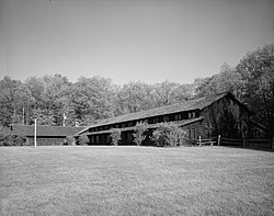
Black Hawk State Park is a state park of Iowa, USA, in the town of Lake View. The park includes land, campgrounds, trails, game preserves, historic structures, and the waters of Black Hawk Lake. Also it is home to the Lake View Water Carnival. This event is held the third full weekend in July every year, and includes many family-friendly activities including a Water Parade. Three sections of the park were listed on the National Register of Historic Places in 1991.

Rim Village is the main area for tourist services in Crater Lake National Park in southern Oregon, United States. It is located on the southwest rim of the caldera overlooking Crater Lake. The National Park Service designed Rim Village to concentrate park services at a location that provided easy access to rim trails and view points. Because of the unique rustic architecture of the Rim Village structures and the surrounding park landscape, the area was listed as Rim Village Historic District on the National Register of Historic Places in 1997.

Comfort Station No. 68 is a historic visitor services building in Crater Lake National Park in southern Oregon, United States. It was built in 1938 to provide a public toilet and shower facilities for park visitors. It was constructed in the National Park Service Rustic style of architecture, and was listed on the National Register of Historic Places in 1988.
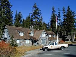
Munson Valley Historic District is the headquarters and main support area for Crater Lake National Park in southern Oregon. The National Park Service chose Munson Valley for the park headquarters because of its central location within the park. Because of the unique rustic architecture of the Munson Valley buildings and the surrounding park landscape, the area was listed as a historic district on the National Register of Historic Places (NRHP) in 1988. The district has eighteen contributing buildings, including the Crater Lake Superintendent's Residence which is a U.S. National Historic Landmark and separately listed on the NRHP. The district's NRHP listing was decreased in area in 1997.

The Devils Kitchen Picnic Shelter in Colorado National Monument was designed by Harvey H. Cornell, Jerome C. Miller and Kenneth M. Saunders of the National Park Service Branch of Plans and Design in 1940. It was built by workers from the Civilian Conservation Corps and the Public Works Administration in 1941, in the National Park Service Rustic style. The shelter features three sandstone fireplaces, as well as toilets and service facilities.
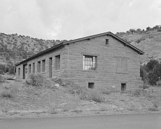
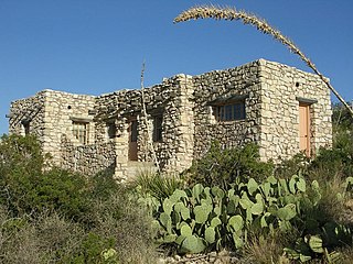
The Saddlehorn Utility Area Historic District in Colorado National Monument comprises a complex of park service buildings, designed by the National Park Service Branch of Plans and Designs in the National Park Service Rustic style. The primary designer was National Park Service architect Kenneth M. Saunders, who employed the local red sandstone in the buildings, which included shops, fuel shed, repair and storage buildings. The buildings were constructed in 1941 by Public Works Administration and Civilian Conservation Corps labor.
The Rocky Mountain National Park Utility Area Historic District in Rocky Mountain National Park documents the early administrative core of the park. Beginning in 1920 and continuing into the 1930s, park service and administrative structures were built in the National Park Service Rustic style. Most buildings were built of logs under a policy of blending with the natural landscape. Later construction has respected the materials and scale of the area. Structures include McLaren Hall, designed by landscape architect W.G. Hill, a number of employee residences including the superintendent's residence, equipment sheds, garages and utility buildings. Many of the buildings built in the 1930s were built by Civilian Conservation Corps labor. The Beaver Meadows Visitor Center is individually listed as a National Historic Landmark.

Lake Ahquabi State Park is a state park of Iowa, US, featuring a 115-acre (47 ha) reservoir. Ahquabi means "resting place" in the Fox language. The park is 6 miles (9.7 km) south of Indianola and 22 miles (35 km) south of Des Moines. Three section of the park were listed on the National Register of Historic Places in 1991.

The Wonderland Trail is an approximately 93 mile (150 km) hiking trail that circumnavigates Mount Rainier in Mount Rainier National Park, Washington, United States. The trail goes over many ridges of Mount Rainier for a cumulative 22,000 feet (6,700 m) of elevation gain. The trail was built in 1915.
The Tahoma Vista Comfort Station was designed by the National Park Service Branch of Plans and Designs in the National Park Service Rustic style and built in Mount Rainier National Park by the Civilian Conservation Corps in 1931. The design was supervised by Park Service Chief Architect Thomas Chalmers Vint, and site selection and development were undertaken by Park Service landscape architect Ernest A. Davidson. The comfort station serves the Tahoma Vista Overlook, also designed by Davidson. The 14-foot (4.3 m) by 30-foot (9.1 m) public toilet facility features rough stonework to window sill level, with a framed wall above and a log-framed roof with cedar shingles.
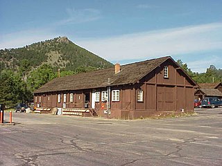
The Caverns Historic District comprises the central developed area of Carlsbad Caverns National Park. The complex was built between the early 1920s and 1942, initially in Pueblo Revival style, and later in New Mexico Territorial Revival style in the area around the natural entrance to Carlsbad Caverns. The earlier structures are built of local limestone, the later buildings in adobe. Thirteen buildings in the district are considered contributing structures. Buildings built between 1940 and 1942 were constructed with labor provided by the Civilian Conservation Corps.

The Lassen Volcanic National Park Highway Historic District includes the main roadway developed within Lassen Volcanic National Park in northern California from 1925 to 1951. The road was developed to allow tourists access to the central part of the national park, and was designed in accordance with National Park Service design principles for naturalistic road design and the National Park Service Rustic style of design and construction. The new road was intended to supplant existing primitive roads that led into the park from the periphery, cutting straight through the park to its major sights. The road is designated California State Route 89.
Architects of the National Park Service are the architects and landscape architects who were employed by the National Park Service (NPS) starting in 1918 to design buildings, structures, roads, trails and other features in the United States National Parks. Many of their works are listed on the National Register of Historic Places, and a number have also been designated as National Historic Landmarks.

Hanover Wayside is a historic wayside and national historic district located near Hanover Courthouse, Hanover County, Virginia. The district includes five contributing buildings, one contributing site, and one contributing structure. It was built about 1937–1938 by the Civilian Conservation Corps (CCC) as a Recreation Demonstration Areas project. The buildings are in the rustic style and include the picnic shelter, wayside caretaker's house and public restroom, and garage.

Lacey-Keosauqua State Park is located southwest of Keosauqua, Iowa, United States. Located along the Des Moines River in Van Buren County, it was dedicated in 1921. It is the largest state park in size in Iowa. In 1990 three areas were named nationally recognized historic districts and listed on the National Register of Historic Places.

Pikes Point State Park is located southwest of Spirit Lake, Iowa, United States. It is a small park on a point of land that projects into West Okoboji Lake. It provides space for picnicking, including a shelter listed on the National Register of Historic Places, a playground, a swimming beach, boating and fishing on the lake.
Trapper's Bay State Park is located on the west side of Lake Park, Iowa, United States. The 57.5-acre (23.3 ha) park is along the north shore of Silver Lake. It provides space for picnicking, including a shelter listed on the National Register of Historic Places, and boating and fishing on the lake.
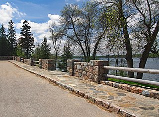
The Orr Roadside Parking Area is a roadside park on U.S. Route 53 in Orr, Minnesota, United States. It was built from 1935 to 1938 as a New Deal project to provide motorists with recreational access to Pelican Lake. It was designed by landscape architect Arthur R. Nichols and constructed by the Civilian Conservation Corps in collaboration with the Minnesota Department of Highways. The overlook was listed on the National Register of Historic Places in 2002 for its state-level significance in the themes of landscape architecture and politics/government. It was nominated for exemplifying the early highway waysides built in Minnesota with federal work relief aid, and for exemplifying National Park Service rustic style and the work of Nichols.