Tonga Trench

Last updated
The major geological relationships of the Tonga Trench (violet) which to the south becomes the Kermadec Trench (violet) at the Osbourn Trough and Louisville Ridge intersection. Blue represents ocean depths of a kilometer or so and brown shades are shallower. Land is shown in dark green and the black line delineates the continent of Zealandia.
The Tonga Trench constitutes the northern half of the Tonga-Kermadec subduction system, which extends 2,550 km (1,580 mi) between New Zealand and Tonga. Kermadec Arc.jpg
The Tonga Trench constitutes the northern half of the Tonga-Kermadec subduction system, which extends 2,550 km (1,580 mi) between New Zealand and Tonga.

The Tonga Trench is an oceanic trench located in the southwestern Pacific Ocean. It is the deepest trench in the Southern hemisphere and the second deepest on Earth after the Mariana Trench. The fastest plate-tectonic velocity on Earth is occurring at this location, as the Pacific Plate is being subducted westward in the trench.

Contents

Horizon Deep

RV Horizon (1948), used as Auxiliary Fleet Tug USS ATA-180 USS ATA-180.jpg
RV Horizon (1948), used as Auxiliary Fleet Tug USS ATA-180

The deepest point of the Tonga Trench, the Horizon Deep at 23°15′30″S174°43′36″W / 23.25833°S 174.726667°W / -23.25833; -174.726667 , is 10,800 ± 10 m (35,433 ± 33 ft) deep, making it the deepest point in the Southern Hemisphere and the second deepest on Earth after the Challenger Deep in the Mariana Trench. It is named for the research vessel Horizon of the Scripps Institution of Oceanography, the crew of which found the deep in December 1952. [2]

As one of the deepest hadal trenches, the sediment of the Horizon Deep harbours a community of roundworms. A 2016 study found that the abundance of individuals in this community is six times greater than it is at a site on the trench edge at approximately 6,250 m (20,510 ft) near the deep and that the difference in biomass between these locations is even bigger. Species diversity, on the other hand, is twice as big on the trench slope, probably because of a small number of opportunistic species in the trench. [3] Figures for abundance and biomass are similar for the deeps of the Mariana Trench but considerably lower in the Peru–Chile Trench. [4]

Crewed descent

Deep Submersible Support Vessel DSSV Pressure Drop and DSV Limiting Factor at its stern Limiting Factor to be prepared for a dive into the Atlantic Ocean.jpg
Deep Submersible Support Vessel DSSV Pressure Drop and DSV Limiting Factor at its stern

The Tonga Trench and the operating area was surveyed by the support ship, the Deep Submersible Support Vessel DSSV Pressure Drop, with a Kongsberg SIMRAD EM124 multibeam echosounder system. The gathered data will be donated to the GEBCO Seabed 2030 initiative. [5] [6] The dive was part of the Five Deeps Expedition. [7] The objective of this expedition is to thoroughly map and visit the deepest points of all five of the world's oceans by the end of September 2019. [7]

As part of the Five Deeps expedition, Sirena Deep, itself 5,750 km (3,570 mi) away from Horizon Deep, was visited by Victor Vescovo on the first crewed descent to the bottom of the Sirena Deep on 5 June 2019 (in the Deep-Submergence Vehicle DSV Limiting Factor, a Triton 36000/2 model submersible) and measured a depth of 10,823 m (35,509 ft) ±10 m (33 ft) by direct CTD pressure measurements. [8] This descent and direct depth measurement of Sirena Deep occurred a month after descending four times to the bottom of the Challenger Deep, which is also approximately 6,000 km away from the Tonga Trench.

Geology

Tonga-Kermadec arc system

The region between the Tonga trench and the Lau back-arc basin, the Tonga-Kermadec Ridge, moves independently from the Australian and Pacific plates and is subdivided into several small plates, the Tonga, Kermadec, and Niuafo'ou plates. The Tonga Plate is facing the Tonga Trench. [9]

The Tonga Trench-Arc system is an extension-dominated, non-accretionary convergent margin. The Pacific Plate is being subducted westward in the trench. The convergence rate has been estimated to 15 cm/year (5.9 in/year) but GPS measurements in the northern trench indicate a convergence rate of 24 cm/year (9.4 in/year) there. [10] This is the fastest plate velocity on Earth, a result is the earth's most active zone of mantle seismicity. [11] Subduction rates decrease southward along the Tonga-Kermadec Arc, from 24 cm/year (9.4 in/year) in the north to 6 cm/year (2.4 in/year) in the south and also become more oblique southward. The high rate in the Tonga Trench is largely due to a reduction in extension in the Lau Basin. [12] Crustal extension in the Miocene Lau-Colville Ridge began at 6 Ma which initiated the opening of the Lau Basin-Havre Trough. This extension has propagated southward since and has developed into a spreading centre in the Lau Basin in front of the Tonga Trench. New crust is thus produced in front of the Tonga-Kermadec trenches while old crust is consumed behind it in the Tonga Trench. [13]

Pacific slab avalanche

While most of the large earthquakes occur at the contact zone between both tectonic plates, related to the friction during subduction, others are produced in the Pacific Plate due to its bending. [14] The Pacific crust that descends into the trench is old, 100–140 Ma, and relatively cold and it can therefore store a lot of elastic energy. As it reaches deep into the mantle, more than 600 km (370 mi), and encounters barriers, it is being contorted, which produces deep mantle earthquakes. [15]

About 500 km (310 mi) beneath the North Fiji Basin, a detached segment of the subducted Australian Plate has collided with the subducted Pacific Plate which produces many large-scale earthquakes. The subducted Pacific Plate is also being deformed in the collision as both slabs settle on the 660 km discontinuity. This slab collision probably occurred 5–4 Ma when the Lau Basin started to open. [16]

Oceanic trenches are important sites for the formation of what will become continental crust and for recycling of material back into the mantle. Along the Tonga Trench mantle-derived melts are transferred to the island arc systems, and abyssal oceanic sediments and fragments of oceanic crust are collected. [10]

Tonga Trench–Lau Basin transition

At its northern end the Tonga Trench bends west into the microplates, interconnected spreading centres, and deformation zones of the Lau Basin. But the Tonga Trench also has a continuation in the inactive Vitiaz Trench (north of map area) with which it formed a single continuous trench before the opening of the North Fiji Basin (west of map area). The Capricorn Seamount (centre right) is sitting on the eastern slope of the trench. Lau Basin-NOAA-Tectonic features hires.jpg
At its northern end the Tonga Trench bends west into the microplates, interconnected spreading centres, and deformation zones of the Lau Basin. But the Tonga Trench also has a continuation in the inactive Vitiaz Trench (north of map area) with which it formed a single continuous trench before the opening of the North Fiji Basin (west of map area). The Capricorn Seamount (centre right) is sitting on the eastern slope of the trench.

The northern end of the Tonga Trench (at 15°10'S) is probably linked to the Fiji Fracture Zone, trending east–west north of Fiji, but the trench ends in a complex transition from subduction to a strike-slip motion and seismicity patterns indicate a presence of a c.100 km-broad (62 mi) transition zone rather than a simple transform fault. In or near this zone there is a ridge-ridge-ridge triple junction ( 15°37′S174°52′W / 15.617°S 174.867°W / -15.617; -174.867 ), known as the King's or Mangatolu Triple Junction (MTJ), characterised by deformation and recent and intense volcanism (see for example Home Reef). The Tofua volcanic arc on the northern Tonga Ridge extends to less than 40 km (25 mi) of the trench's northern end. [17]

Just north of the MTJ lies the south–north-trending Northeast Lau Spreading Centre (NELSC) which intercepts the northern end of the Tonga Trench and is one of three major spreading centres in the northern Lau Basin (together with the Futuna Spreading Centre and Northwest Lau Spreading Centre). The maximum spreading rate in the NELSC is 94 mm/a (3.7 in/year) but spreading decreases to zero at either end of the spreading centre. The total spreading rate between the Tongan and Australian plates, however, is 157 mm/a (6.2 in/year), and additional microplates and/or deformations zones must thus exist. The NELSC probably receives magmatic contributions from the Samoa hotspot. [18] The NELSC has a morphology which is similar to those of slow-spreading ridges with many closely packed ridges and troughs reaches. Where it meets the trench, a ridge-transform-transform boundary is developing between the Tonga Ridge, the Pacific Plate, and the Australian Plate. [17]

North-east of the 60° bend in the Tonga Trench the Pacific seafloor is full of parallel lineations. These have been interpreted as remnants of an extinct, east-to-west-trending spreading centre on the Pacific Plate, much older than the Tonga Trench. [17]

Louisville Seamount Chain collision

At its southern end (c.26°S) the Tonga Trench is colliding with the Louisville Seamount Chain, a chain of guyots and seamounts on the Pacific Plate roughly parallel to the Hawaiian–Emperor seamount chain in the northern pacific. The Louisville collision zone migrates southward at a rate of 18 cm/year (7.1 in/year) because of the difference in the oblique angle between the Louisville Ridge relative the direction of convergence. In the eastern Lau Basin spreading centres are propagating southward at roughly the same rate. The collision zone also offsets the Tonga Trench to the north-west relative to the Kermadec Trench by c.50 km (31 mi). [10] The subducting Louisville Ridge has caused a significant amount of erosion on the outer edge of the southern Tonga fore-arc and has probably accelerated subsidence in the Tonga Trench, a process which makes the Tonga Trench the second deepest trench on Earth and considerably deeper than the Kermadec Trench. [19]

The oldest and westernmost of the Louisville seamounts, the Osbourn Seamount, is sitting on the edge of the trench and its former flat top is currently tilting towards the trench. [20] West of the Osbourn Seamount a broad zone of faulted blocks shallows the trench by 3,000 m (9,800 ft) while the adjacent fore-arc is elevated by c.300 m (980 ft) and covered by canyons. [21]

The Louisville collision zone correlates with a zone of seismic quiescence along the Tonga-Kermadec Trench known as the "Louisville Gap". This gap in seismicity indicates that subducting seamounts inhibit or even prevent seismicity at subduction zones, perhaps by increasing intervals between earthquakes, but the mechanism behind this process is poorly understood. [22]

Geochemical evidence suggests that the Louisville chain has been subducting under the Tonga-Kermadec Arc since 4 Ma. Seismic studies have identified a southward, along-arc mantle flow that indicate that Pacific mantle is being replaced by Indo-Australian mantle west of the Tonga Trench. [23]

Osbourn Trough

The Osbourn Trough, located at 25.5°S just north of the Louisville Ridge collision zone, is a 900 km (560 mi)-long extinct spreading ridge midway between two large oceanic plateaux north and south of the Tonga Trench respectively: Manihiki 1,750 km (1,090 mi) to the north and Hikurangi 1,550 km (960 mi) to the south. These plateaux once formed part of the 100×10^6 km3 (3.5×10¹⁸ cu ft) Ontong Java-Manihiki-Hikurangi large igneous province (LIP). Spreading between the plateaux ceased when Hikurangi collided with the Chatham Rise east of New Zealand which had been estimated to have been at 86 Ma, [24] although may be as recent as 79 Ma. [25] The western end of the Osbourn Trough is bounded by the Tonga Trench and its eastern by the Wishbone–East Manihiki scarp. In between the Osbourn Trough is divided into three segments separated by dextral offsets. Near the Tonga Trench the bathymetry of these structures is affected by the rotation of the Pacific Plate. [26]

Capricorn Seamount

The Capricorn Seamount is a guyot located on the eastern wall of the northern Tonga Trench (see map above). It is a large guyot, 100 km (62 mi) wide at its base with a small part of its reefal or lagoonal summit reaching 440 m (1,440 ft) below sea level. The bending of the Pacific Plate at the Tonga Trench is currently slicing it like a loaf of bread: inside the guyot a north–south-trending horst and graben system is developing parallel to the trench; the western slope of the guyot has reached the 9,000 m deep (30,000 ft) trench and has started to fill it; the summit of the guyot is tilted 1.7° towards the trench and its centre is only 45 km (28 mi) from the trench axis. [27] The Capricorn Seamount is expected to be completely consumed by the trench within 500,000 years. [28]

Apollo 13

When the Apollo 13 mission was aborted in 1970 following an explosion in an oxygen tank, it had to bring the entire Lunar Module back to Earth. As the LEM was jettisoned prior to reentry, its radioisotope thermoelectric generator broke up in the atmosphere, and the heat source plunged into an area of the Pacific Ocean that is either in or near the Tonga Trench. However, due to protective casing, no release of 238Pu (half-life of 87.7 years) used as heat source in the thermoelectric generator could be detected by atmospheric and oceanic monitoring. [29]

See also

Related Research Articles

<span class="mw-page-title-main">Oceanic trench</span> Long and narrow depressions of the sea floor

Oceanic trenches are prominent, long, narrow topographic depressions of the ocean floor. They are typically 50 to 100 kilometers wide and 3 to 4 km below the level of the surrounding oceanic floor, but can be thousands of kilometers in length. There are about 50,000 km (31,000 mi) of oceanic trenches worldwide, mostly around the Pacific Ocean, but also in the eastern Indian Ocean and a few other locations. The greatest ocean depth measured is in the Challenger Deep of the Mariana Trench, at a depth of 10,920 m (35,830 ft) below sea level.

<span class="mw-page-title-main">Kermadec Trench</span> Linear ocean trench in the South Pacific

The Kermadec Trench is a linear ocean trench in the south Pacific Ocean. It stretches about 1,000 km (620 mi) from the Louisville Seamount Chain in the north (26°S) to the Hikurangi Plateau in the south (37°S), north-east of New Zealand's North Island. Together with the Tonga Trench to the north, it forms the 2,000 km (1,200 mi)-long, near-linear Kermadec-Tonga subduction system, which began to evolve in the Eocene when the Pacific Plate started to subduct beneath the Australian Plate. Convergence rates along this subduction system are among the fastest on Earth, 80 mm (3.1 in)/yr in the north and 45 mm (1.8 in)/yr in the south.

<span class="mw-page-title-main">Back-arc basin</span> Submarine features associated with island arcs and subduction zones

A back-arc basin is a type of geologic basin, found at some convergent plate boundaries. Presently all back-arc basins are submarine features associated with island arcs and subduction zones, with many found in the western Pacific Ocean. Most of them result from tensional forces, caused by a process known as oceanic trench rollback, where a subduction zone moves towards the subducting plate. Back-arc basins were initially an unexpected phenomenon in plate tectonics, as convergent boundaries were expected to universally be zones of compression. However, in 1970, Dan Karig published a model of back-arc basins consistent with plate tectonics.

<span class="mw-page-title-main">Izu–Bonin–Mariana Arc</span> Convergent boundary in Micronesia

The Izu–Bonin–Mariana (IBM) arc system is a tectonic plate convergent boundary in Micronesia. The IBM arc system extends over 2800 km south from Tokyo, Japan, to beyond Guam, and includes the Izu Islands, the Bonin Islands, and the Mariana Islands; much more of the IBM arc system is submerged below sealevel. The IBM arc system lies along the eastern margin of the Philippine Sea Plate in the Western Pacific Ocean. It is the site of the deepest gash in Earth's solid surface, the Challenger Deep in the Mariana Trench.

<span class="mw-page-title-main">Kermadec-Tonga subduction zone</span> Convergent plate boundary that stretches from the North Island of New Zealand northward

The Kermadec-Tonga subduction zone is a convergent plate boundary that stretches from the North Island of New Zealand northward. The formation of the Kermadec and Tonga Plates started about 4–5 million years ago. Today, the eastern boundary of the Tonga Plate is one of the fastest subduction zones, with a rate up to 24 cm/yr. The trench formed between the Kermadec-Tonga and Pacific Plates is also home to the second deepest trench in the world, at about 10,800 m, as well as the longest chain of submerged volcanoes.

<span class="mw-page-title-main">Macquarie Fault Zone</span> Lateral-moving transform fault south of New Zealand

The 1,600 kilometres (990 mi) long Macquarie Fault Zone is a major right lateral-moving transform fault along the seafloor of the south Pacific Ocean which runs from New Zealand southwestward towards the Macquarie Triple Junction. It is also the tectonic plate boundary between the Australian Plate to the northwest and the Pacific Plate to the southeast. As such it is a region of high seismic activity and recorded the largest strike-slip event on record up to May 23, 1989, of at least Mw8.0

<span class="mw-page-title-main">Louisville Ridge</span> Chain of over 70 seamounts in the Southwest Pacific Ocean

The Louisville Ridge, often now referred to as the Louisville Seamount Chain, is an underwater chain of over 70 seamounts located in the Southwest portion of the Pacific Ocean. As one of the longest seamount chains on Earth it stretches some 4,300 km (2,700 mi) from the Pacific-Antarctic Ridge northwest to the Tonga-Kermadec Trench, where it subducts under the Indo-Australian Plate as part of the Pacific Plate. The chains formation is best explained by movement of the Pacific Plate over the Louisville hotspot although others had suggested by leakage of magma from the shallow mantle up through the Eltanin fracture zone, which it follows closely for some of its course.

The Osbourn Seamount is a seamount in the south-west Pacific Ocean. It is the westernmost and oldest unsubducted seamount of the Louisville Ridge, with an estimated age of 78.8 ± 1.3 Ma. Like other seamounts comprising the Louisville Ridge, it was formed by the Louisville hotspot which is currently located 4,300 km (2,700 mi) away near the Pacific-Antarctic Ridge.

<span class="mw-page-title-main">Mariana Plate</span> Small tectonic plate west of the Mariana Trench

The Mariana Plate is a micro tectonic plate located west of the Mariana Trench which forms the basement of the Mariana Islands which form part of the Izu–Bonin–Mariana Arc. It is separated from the Philippine Sea Plate to the west by a divergent boundary with numerous transform fault offsets. The boundary between the Mariana and the Pacific Plate to the east is a subduction zone with the Pacific Plate subducting beneath the Mariana. This eastern subduction is divided into the Mariana Trench, which forms the southeastern boundary, and the Izu–Ogasawara Trench the northeastern boundary. The subduction plate motion is responsible for the shape of the Mariana plate and back arc.

<span class="mw-page-title-main">Lau Basin</span> Oceanic basin in the South Pacific Ocean between Fiji and Tonga

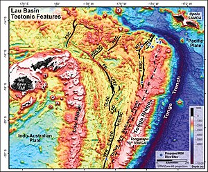
The Lau Basin is a back-arc basin at the Australian-Pacific plate boundary. It is formed by the Pacific plate subducting under the Australian plate. The Tonga-Kermadec Ridge, a frontal arc, and the Lau-Colville Ridge, a remnant arc, sit to the eastern and western sides of the basin, respectively. The basin has a raised transition area to the south where it joins the Havre Trough.

<span class="mw-page-title-main">Geology of the Pacific Ocean</span> Overview about the geology of the Pacific Ocean

The Pacific Ocean evolved in the Mesozoic from the Panthalassic Ocean, which had formed when Rodinia rifted apart around 750 Ma. The first ocean floor which is part of the current Pacific Plate began 160 Ma to the west of the central Pacific and subsequently developed into the largest oceanic plate on Earth.

<span class="mw-page-title-main">North Fiji Basin</span>

The North Fiji Basin (NFB) is an oceanic basin west of Fiji in the south-west Pacific Ocean. It is an actively spreading back-arc basin delimited by the Fiji islands to the east, the inactive Vitiaz Trench to the north, the Vanuatu/New Hebrides island arc to the west, and the Hunter fracture zone to the south. Roughly triangular in shape with its apex located at the northern end of the New Hebrides Arc, the basin is actively spreading southward and is characterised by three spreading centres and an oceanic crust younger than 12 Ma. The opening of the NFB began when a slab roll-back was initiated beneath the New Hebrides and the island arc started its clockwise rotation. The opening of the basin was the result of the collision between the Ontong Java Plateau and the Australian Plate along the now inactive Solomon–Vitiaz subduction system north of the NFB. The NFB is the largest and most developed back-arc basin of the south-west Pacific. It is opening in a complex geological setting between two oppositely verging subduction systems, the New Hebrides/Vanuatu and Tonga trenches and hence its ocean floor has the World's largest amount of spreading centres per area.

<span class="mw-page-title-main">Tonga-Kermadec Ridge</span> Oceanic ridge in the south-west Pacific Ocean underlying the Tonga-Kermadec island arc

The Tonga-Kermadec Ridge is an oceanic ridge in the south-west Pacific Ocean underlying the Tonga-Kermadec island arc. It is a result of the most linear, fastest converging, and seismically active subduction boundary on Earth, the Kermadec-Tonga subduction zone, and consequently has the highest density of submarine volcanoes.

<span class="mw-page-title-main">Monowai (seamount)</span> Volcanic seamount north of New Zealand

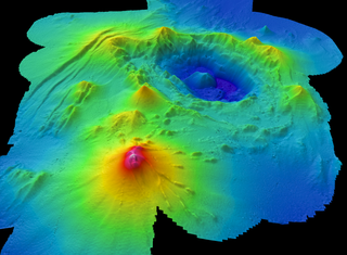
Monowai Seamount is a volcanic seamount to the north of New Zealand. It is formed by a large caldera and a volcanic cone just south-southeast from the caldera. The volcanic cone rises to depths of up to 100 metres (330 ft) but its depth varies with ongoing volcanic activity, including sector collapses and the growth of lava domes. The seamount and its volcanism were discovered after 1877, but only in 1980 was it named "Monowai" after a research ship of the same name.

<span class="mw-page-title-main">Capricorn Seamount</span> Seamount in the Pacific Ocean

Capricorn Seamount is a seamount in Tonga. It rises 4 kilometres (2.5 mi) to a depth of about 360 m (1,180 ft) and is capped off by a 15 km (9.3 mi) wide summit platform. It appears to be a submerged volcano of Miocene age that may be part of a volcanic chain with Niue. Capricorn Seamount is located on the eastern flank of the Tonga Trench and is in the process of breaking up; in turn the trench has been altered by the interaction with the downgoing seamount.

<span class="mw-page-title-main">Wishbone scarp</span> An ocean floor tectonic feature of the Pacific Ocean

The Wishbone scarp is a Pacific Ocean floor feature in the oceanic crust, that if it were on land would be similar to a mountain range fault system over 1,000 km (620 mi) long. It commences in the north near the Osbourn Trough although it is likely to be related tectonically to the Manihiki scarp somewhat to its north. To the south it splits into west and east scarps that have been intercepted by the Louisville hotspot with the West Wishbone scarp continuing until it intercepts the Chatham Rise. There is now evidence that the entire scarp has a fracture zone origin resolving previous uncertainty on this issue.

<span class="mw-page-title-main">Osbourn Trough</span> Deep oceanic basin in the southwestern Pacific Ocean

The Osbourn Trough, is a 900 km (560 mi)-long extinct mid-ocean ridge, that may have stopped spreading as recently as 79 million years ago. It is a west-to-east oriented sea floor feature, located to the east of the present Tonga-Kermadec Ridge where the present Pacific Plate is under going subduction under a micro-plate of the Australian Plate. The Osbourn Trough is key to understanding the postulated breakup mechanism of the historic massive Ontong Java-Manihiki-Hikurangi large igneous province (LIP), as it has been shown to be the spreading centre that lead to the separation of the Manihiki Plateau to its north and the Hikurangi Plateau to its south close to New Zealand.

<span class="mw-page-title-main">Lau-Colville Ridge</span> Oceanic ridge in the south-west Pacific Ocean between Fiji and New Zealand

The Lau-Colville Ridge is an extinct oceanic ridge located on the oceanic Australian Plate in the south-west Pacific Ocean extending about 2,700 km (1,700 mi) from the south east of Fiji to the continental shelf margin of the North Island of New Zealand. It was an historic subduction boundary between the Australian Plate and the Pacific Plate and has important tectonic relationships to its east where very active spreading and subduction processes exist today. It is now the inactive part of an eastward-migrating, 100 million year old Lau-Tonga-Havre-Kermadec arc/back-arc system or complex and is important in understanding submarine arc volcanism because of these relationships. To its west is the South Fiji Basin whose northern bedrock is Oligocene in origin.

<span class="mw-page-title-main">Havre Trough</span> Oceanic rift valley in the south-west Pacific Ocean to the north of New Zealand

The Havre Trough is a currently actively rifting back-arc basin about 100 km (62 mi) to 120 km (75 mi) wide, between the Australian Plate and Kermadec microplate. The trough extends northward from New Zealand's offshore Taupō Volcanic Zone commencing at Zealandia's continental shelf margin and continuing as a tectonic feature, as the Lau Basin which currently contains active seafloor spreading centers. Its eastern margin is defined by the Kermadec Ridge created by Pacific Plate subduction under the Kermadec microplate, while the western margin is the remnant Lau-Colville Ridge.

<span class="mw-page-title-main">South Fiji Basin</span> Oceanic basin in the south-west Pacific Ocean between Fiji and New Zealand

The South Fiji Basin is a large 4 to 4.7 km deep oceanic basin in the south-west Pacific Ocean, south of Fiji. It was formed from the then Indo-Australian Plate and is delimited to the north west by the New Hebrides Trench, and the Hunter Fracture Zone, to the west by the Three Kings Ridge, to the east by the Lau-Colville Ridge, and to the south by the continental shelf of Zealandia.

References

Notes

  1. Smith & Price 2006 , p. 316
  2. "GEBCO Gazetteer of Undersea Feature Names". GEBCO. 26 April 2015. Retrieved 9 April 2017.
  3. Leduc et al. 2016 , Abstract
  4. Leduc et al. 2016 , p. 8
  5. The Nippon Foundation-GEBCO Seabed 2030 Project
  6. "Major partnership announced between The Nippon Foundation-GEBCO Seabed 2030 Project and The Five Deeps Expedition". gebco.net. 11 March 2019. Retrieved June 19, 2019.
  7. 1 2 "The Five Deeps Expedition: Home". fivedeeps.com. Retrieved January 9, 2019.
  8. "CONFIRMED: Horizon Deep Second Deepest Point on the Planet" (PDF). fivedeeps.com. Retrieved June 19, 2019.
  9. Bird 2003 , Tonga Plate (TO), Kermadec Plate (KE), and Niuafo’ou Plate (NI), p. 28
  10. 1 2 3 Wright et al. 2000 , Geologic setting, pp. 490–491
  11. Bevis et al. 1995 , Abstract
  12. Smith et al. 2003 , p. 100
  13. Smith et al. 2003 , p. 114
  14. Garcia-Castellanos, Torne & Fernandez 2000
  15. Bevis et al. 1995 , p. 251
  16. Richards, Holm & Barber 2011 , Abstract
  17. 1 2 3 Wright et al. 2000 , Map 1: A strike-slip boundary and the termination of the Trench, pp. 499–502
  18. German et al. 2006 , pp. 3–4
  19. Contreras‐Reyes et al. 2011 , Fig. 1, p. 2; [6], p. 2
  20. Contreras‐Reyes et al. 2011 , 4:12; 14:38
  21. Stratford et al. 2015 , p. 6, Geological setting
  22. Peirce & Watts 2010 , The Louisville Ridge–Tonga Trench collision, pp. 9–11; Fig. 3, p. 10
  23. Timm et al. 2013 , p. 2
  24. Worthington et al. 2006 , Abstract
  25. van de Lagemaat, Suzanna H.A.; Kamp, Peter J.J.; Boschman, Lydian M.; van Hinsbergen, Douwe J.J. (2023). "Reconciling the Cretaceous breakup and demise of the Phoenix Plate with East Gondwana orogenesis in New Zealand" (PDF). Earth-Science Reviews. 236 (104276). doi: 10.1016/j.earscirev.2022.104276 . ISSN   0012-8252.
  26. Worthington et al. 2006 , pp. 686–687
  27. Hill & Glasby 1996 , Abstract; Morphology and Seismic Evidence, pp. 21–24
  28. Hill & Glasby 1996 , p. 20
  29. Furlong & Wahlquist 1999 , p. 27

Sources

22°S174°W / 22°S 174°W / -22; -174