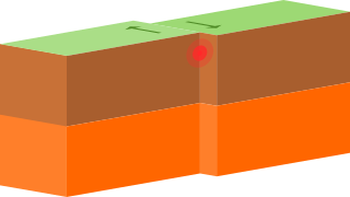
A transform fault or transform boundary is a plate boundary where the motion is predominantly horizontal. It ends abruptly and is connected to another transform, a spreading ridge, or a subduction zone.

The Coast Mountains are a major mountain range in the Pacific Coast Ranges of western North America, extending from southwestern Yukon through the Alaska Panhandle and virtually all of the Coast of British Columbia south to the Fraser River. The mountain range's name derives from its proximity to the sea coast, and it is often referred to as the Coast Range. The range includes volcanic and non-volcanic mountains and the extensive ice fields of the Pacific and Boundary Ranges, and the northern end of the volcanic system known as the Cascade Volcanoes. The Coast Mountains are part of a larger mountain system called the Pacific Coast Ranges or the Pacific Mountain System, which includes the Cascade Range, the Insular Mountains, the Olympic Mountains, the Oregon Coast Range, the California Coast Ranges, the Saint Elias Mountains and the Chugach Mountains. The Coast Mountains are also part of the American Cordillera—a Spanish term for an extensive chain of mountain ranges—that consists of an almost continuous sequence of mountain ranges that form the western backbone of North America, Central America, South America and Antarctica.
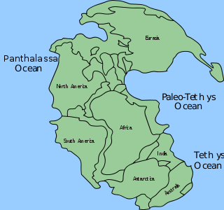
Panthalassa, also known as the Panthalassic Ocean or Panthalassan Ocean, was the superocean that surrounded the supercontinent Pangaea. During the Paleozoic–Mesozoic transition c. 250 Ma it occupied almost 70% of Earth's surface. Its ocean floor has completely disappeared because of the continuous subduction along the continental margins on its circumference. Panthalassa is also referred to as the Paleo-Pacific or Proto-Pacific because the Pacific Ocean developed from its centre in the Mesozoic to the present.

The Basin and Range Province is a vast physiographic region covering much of the inland Western United States and northwestern Mexico. It is defined by unique basin and range topography, characterized by abrupt changes in elevation, alternating between narrow faulted mountain chains and flat arid valleys or basins. The physiography of the province is the result of tectonic extension that began around 17 million years ago in the early Miocene epoch.

The Laramide orogeny was a period of mountain building in western North America, which started in the Late Cretaceous, 70 to 80 million years ago, and ended 35 to 55 million years ago. The exact duration and ages of beginning and end of the orogeny are in dispute. The Laramide orogeny occurred in a series of pulses, with quiescent phases intervening. The major feature that was created by this orogeny was deep-seated, thick-skinned deformation, with evidence of this orogeny found from Canada to northern Mexico, with the easternmost extent of the mountain-building represented by the Black Hills of South Dakota. The phenomenon is named for the Laramie Mountains of eastern Wyoming. The Laramide orogeny is sometimes confused with the Sevier orogeny, which partially overlapped in time and space.
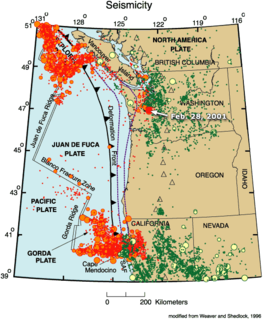
The Gorda Plate, located beneath the Pacific Ocean off the coast of northern California, is one of the northern remnants of the Farallon Plate. It is sometimes referred to as simply the southernmost portion of the neighboring Juan de Fuca Plate, another Farallon remnant.
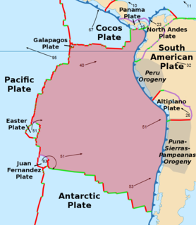
The Nazca Plate, named after the Nazca region of southern Peru, is an oceanic tectonic plate in the eastern Pacific Ocean basin off the west coast of South America. The ongoing subduction, along the Peru–Chile Trench, of the Nazca Plate under the South American Plate is largely responsible for the Andean orogeny. The Nazca Plate is bounded on the west by the Pacific Plate and to the south by the Antarctic Plate through the East Pacific Rise and the Chile Rise respectively. The movement of the Nazca Plate over several hotspots has created some volcanic islands as well as east-west running seamount chains that subduct under South America. Nazca is a relatively young plate both in terms of the age of its rocks and its existence as an independent plate having been formed from the break-up of the Farallon Plate about 23 million years ago. The oldest rocks of the plate are about 50 million years old.

A mid-ocean ridge (MOR) is an underwater mountain system formed by plate tectonics. It consists of various mountains linked in chains, typically having a valley known as a rift running along its spine. This type of oceanic mountain ridge is characteristic of what is known as an 'oceanic spreading center', which is responsible for seafloor spreading. The production of new seafloor results from mantle upwelling in response to plate spreading; this isentropic upwelling solid mantle material eventually exceeds the solidus and melts. The buoyant melt rises as magma at a linear weakness in the oceanic crust, and emerges as lava, creating new crust upon cooling. A mid-ocean ridge demarcates the boundary between two tectonic plates, and consequently is termed a divergent plate boundary.
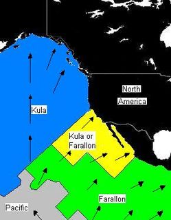
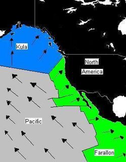
The Kula Plate was an oceanic tectonic plate under the northern Pacific Ocean south of the Near Islands segment of the Aleutian Islands. It has been subducted under the North American Plate at the Aleutian Trench, being replaced by the Pacific Plate.

The Mendocino Fracture Zone is a fracture zone and transform boundary off the coast of Cape Mendocino in far northern California. It runs westward from a triple junction with the San Andreas Fault and the Cascadia subduction zone to the southern end of the Gorda Ridge. It continues on west of its junction with the Gorda Ridge, as an inactive remnant section which extends for several hundred miles.
The Phoenix Plate was an ancient tectonic plate that existed during the mid-Cretaceous through early Cenozoic time. The remainder of the plate is now located east of the Drake Passage/Shackleton Fracture Zone.
The Farallon Trench was a subduction related tectonic formation located off the coast of the western California continental margin during the late to mid Cenozoic era, around 50 miles southeast of modern-day Monterey Bay. The time duration of subduction began from around 165 Ma when the Farallon Plate replaced the Mezczlera promontory, until the San Andreas Fault straightening around 35 Ma. As data accumulated over time, a common view developed that one large oceanic plate, the Farallon Plate, acted as a conveyor belt, conveying accreted terranes onto the North American west coast. As the continent overran the subducting Farallon Plate, the denser plate became subducted into the mantle below the continent. When the plates converged, the dense oceanic plate sank into the mantle to form a slab below the lighter continent. Rapid subduction under the southwestern North America continent began 40 to 60 million years ago (Ma), during the mid Paleocene to mid Eocene epochs. This convergent subduction margin created a distinctive geomorphologic feature called an oceanic trench, which occurs at a convergent plate boundaries as a heavy metal rich, lithospheric plate moves below a light silica rich continental plate. The trench marks the position at which the flexed subducting slab begins to descend beneath and deform the continental plate margin. By 43 Ma, during the Eocene, worldwide plate motions changed and the Pacific Plate began to move away from North America and subduction of the Farallon Plate slowed dramatically. By around 36 Ma, the easternmost part of the East Pacific Rise, located between the Pioneer and Murray fracture zones at that time, approached the trench and the young, hot, buoyant lithosphere appears to have clogged part of the subduction zone, resulting in widespread dramatic uplift on land. The eventual complete subduction of this plate, consequential contact of the Pacific Plate with the California continental margin, and creation of the Mendocino Triple Junction (MTJ), took place around 30 to 20 Ma. The partial complete subduction and division of the Farallon Plate by the Pacific Plate, created the Juan de Fuca Plate to the north and the Cocos Plate to the south. The final stages of the evolution of California’s continental margin was the growth of the San Andres transform fault system, which formed as the Pacific Plate came into contact with the continental margin and the MTJ was formed. As subduction of the Pacific Plate continued along this margin, and the contact zone grew, the San Andres proportionally grew as well.

The Afar Triple Junction is located along a divergent plate boundary dividing the Nubian, Somali, and Arabian plates. This area is considered a present-day example of continental rifting leading to seafloor spreading and producing an oceanic basin. Here, the Red Sea Rift meets the Aden Ridge and the East African Rift. It extends a total of 6,500 kilometers (4,000 mi) in three arms from the Afar Triangle to Mozambique.

The South American–Antarctic Ridge is the tectonic spreading center between the South American Plate and the Antarctic Plate. It runs along the sea-floor from the Bouvet Triple Junction in the South Atlantic Ocean south-westward to a major transform fault boundary east of the South Sandwich Islands. Near the Bouvet Triple Junction the spreading half rate is 9 mm/a (0.35 in/year), which is slow, and the SAAR has the rough topography characteristic of slow-spreading ridges.

The Macquarie Triple Junction is a geologically active tectonic boundary located at 61°30′S161°0′E at which the Indo-Australian Plate, Pacific Plate, and Antarctic Plate collide and interact. The term Triple Junction is given to particular tectonic boundaries at which three separate tectonic plates meet at a specific, singular location. The Macquarie Triple Junction is located on the seafloor of the southern region of the Pacific Ocean, just south of New Zealand. This tectonic boundary was named in respect to the nearby Macquarie Island, which is located southeast of New Zealand.
The Pacific-Farallon Ridge was a spreading ridge during the late Cretaceous that extended 10,000 km in length and separated the Pacific Plate to the west and the Farallon Plate to the east. It ran south from the Pacific-Farallon-Kula triple junction at 51°N to the Pacific-Farallon-Antarctic triple junction at 43°S. As the Farallon Plate subducted obliquely under the North American Plate, the Pacific-Farallon Ridge approached and eventually made contact with the North American Plate about 30 million years ago. On average, this ridge had an equatorial spreading rate of 13.5 cm per year until its eventual collision with the North American Plate. In present day, the Pacific-Farallon Ridge no longer formally exists since the Farallon Plate has been broken up or subducted beneath the North American Plate, and the ridge has segmented, having been mostly subducted as well. The most notable remnant of the Pacific-Farallon Ridge is the 4000 km Pacific-Nazca segment of the East Pacific Rise.

The Manihiki Plateau is an oceanic plateau in the south-west Pacific Ocean. The Manihiki Plateau was formed by volcanic activity 125 to 120 million years ago during the mid-Cretaceous period at a triple junction plate boundary called the Tongareva triple junction. 125 million years ago the Manihiki Plateau formed part of the giant Ontong Java-Manihiki-Hikurangi plateau.
This is a list of articles related to plate tectonics and tectonic plates.

The Shatsky Rise is Earth's third largest oceanic plateau, located in the north-west Pacific Ocean 1,500 km (930 mi) east of Japan. It is one of a series of Pacific Cretaceous large igneous provinces (LIPs) together with Hess Rise, Magellan Rise, and Ontong Java-Manihiki-Hikurangi. It was named for Nikolay Shatsky (1895-1960), a Soviet geologist, expert in tectonics of ancient platforms.


