Afar Triple Junction

Last updated
The triple junction is at
.mw-parser-output .geo-default,.mw-parser-output .geo-dms,.mw-parser-output .geo-dec{display:inline}.mw-parser-output .geo-nondefault,.mw-parser-output .geo-multi-punct{display:none}.mw-parser-output .longitude,.mw-parser-output .latitude{white-space:nowrap}
11deg30'N 43deg00'E / 11.500degN 43.000degE / 11.500; 43.000Coordinates:
11deg30'N 43deg00'E / 11.500degN 43.000degE / 11.500; 43.000
, inside the Afar Triangle (at center shaded red). Fault lines are in black, and red triangles show historically active volcanoes. Tectonical map of East Africa.png
The triple junction is at 11°30′N43°00′E / 11.500°N 43.000°E / 11.500; 43.000 Coordinates: 11°30′N43°00′E / 11.500°N 43.000°E / 11.500; 43.000 , inside the Afar Triangle (at center shaded red). Fault lines are in black, and red triangles show historically active volcanoes.

The Afar Triple Junction (also called the Afro-Arabian Rift System) is located along a divergent plate boundary dividing the Nubian, Somali, and Arabian plates. This area is considered a present-day example of continental rifting leading to seafloor spreading and producing an oceanic basin. Here, the Red Sea Rift meets the Aden Ridge and the East African Rift. The latter extends a total of 6,500 kilometers (4,000 mi) from the Afar Triangle to Mozambique. [1]

Contents

The connecting three arms form a triple junction. The northernmost branching arm extends north through the Red Sea and into the Dead Sea, while the eastern arm extends through the Gulf of Aden and connects to the Mid-Indian Ocean ridge further to the east. Both of these rifting arms are below sea level and are similar to a mid-ocean ridge. [1]

The third rifting arm runs south extending around 4,000 kilometres (2,500 mi) through the countries of Kenya, Uganda, the Democratic Republic of Congo, Rwanda, Burundi, Tanzania, Zambia, Malawi and, finally, Mozambique. This southern rifting arm is better known as the East African Rift or the East African Rift System (EARS), when it includes the Afar Triangle.

Doming and rifting

A rift is the result of pulling apart or extension of lithosphere, including the crust, caused by mantle upwelling where hotter asthenosphere magma rises up into the colder lithosphere to stretch and thin it.

The internal dynamics of a rift system. Riftxsection.jpg
The internal dynamics of a rift system.

The triple rift is thought to have begun in the Late Cretaceous epoch to the Paleogene period. At that time the African plate was experiencing far-field stresses caused by portions of the northern boundary of the African plate subducting under the Eurasian plate. Today, the Arabian plate is experiencing a crustal down pull, or slab pull, that has separated from the African plate. At the same time as the subduction in the north, there was mantle upwelling causing the crust to down warp and swell into domes throughout the East African Rift System. The Kenyan dome has been studied extensively.

The plume is thought to have begun under Lake Tana in Ethiopia. [1] Based on the environmental correlations and current topographic locations of the Jurassic Upper Limestone and Cretaceous Upper Sandstone, the net rock uplift of the Ethiopian Plateau would be 2.2 km (1.4 mi) since c.150 Mya. The thinned Ethiopian lithosphere could have resulted in ponding from mantle plume and subsequent uplift.

Gani et al. (2007) propose that episodic increase of incision of the Ethiopian Plateau suggests episodic growth rates within the plateau, since the incision rates have no correlation to the past climate events. As an effect of Archimedes' principle of isostatic rebound, 2.05 km uplift has occurred within the last 30 million years. [2] Baker et al. (1972) also suggest that the uplift of this area is sporadic and divided by long periods of stability and erosion. Some periods of uplift are recorded at the end of the Cretaceous that resulted in 400 metres (1,300 ft) of uplift and the end of the Neogene with a staggering 1,500 metres (4,900 ft) in magnitude. [3] The Ethiopian dome experienced its largest uplift coinciding with the end of the Neogene uplift associated with the Kenyan dome. It has been argued that the current Ethiopian plateau is a result of the most recent uplift of 500 metres (1,600 ft) estimated to be an Oligocene–early Miocene event. But the most accepted argument of the plateau is the result of the Paleogene flood-basalts. The uplift associated with both domes has resulted in major structural features due to the swelling and warped crustal extension. The two areas of swelling resulted in a large depression between the two domes and subsidence along the coastal regions. The uplift caused by the Ethiopian dome resulted in a massive faulting area of 1,000 metres (3,300 ft) in the Afar region. [4]

East African Rift

The East African Rift is an active rift between the Nubian and Somali protoplates. This rift is caused by elevated heat flow from the mantle under Kenya and the Afar region. Trending NNE to SSW, the East African Rift is composed of a western and an eastern branch. The eastern branch (sometimes called the Gregory Rift) is characterized by high volcanic activity and the western branch (sometimes called the Albertine Rift) is characterized by deeper basins, which contain lakes and sediments. The lakes in this area (e.g. Lake Tanganyika and Lake Rukwa) are located in highly rifted basins and have an inter-fingering relationship with faults. Many of the lakes are bounded by normal or strike-slip faults. [1] The extension rate for this rift starts at about 6 millimetres per year (0.24 in/year) in the north, and declines to the south. [5]

Red Sea Rift

Manda-Hararo rift in the Afar region of Ethiopia with Dabbahu Volcano in the background Manda-Hararo rift, Afar.jpg
Manda-Hararo rift in the Afar region of Ethiopia with Dabbahu Volcano in the background

The Red Sea Rift is between the African (or Nubian) and Arabian Plates. The rift runs along the length of the Red Sea, starting from the Dead Sea to the Afar triple junction. Within the rift, in the Red Sea, there are many volcanoes, including the Jabal al-Tair. The extension rate for this rift varies from about 7 to 17 millimetres per year (0.28 to 0.67 in/year). [6]

Aden Ridge

The Aden Ridge is a divergent plate boundary that divides the African (or Somali) and Arabian Plate. It extends from the triple junction eastward to the Owen Fracture Zone, where it meets the Aden-Owen-Carlsberg triple junction between the African, Arabian, and Indo-Australian plates. The spreading rate for Aden Ridge is about 17 millimetres per year (0.67 in/year) near the Afar Triple Junction. [7]

Afar Depression

Before the initial rifting began, Africa was one plate, but as rifting proceeded the plate it began to tear into the Arabian, Somali, and Nubian plates (with the Nubian still sometimes called the African plate).

According to McKenzie and Morgan's 1969 classification, the Afar Triple Junction is of ridge-ridge-ridge (RRR) type, describing the movement of the three plates with respect to each other. The Arabian, Somali, and Nubian plates are all divergent margins, or ridges, with respect to the adjacent plates. Following Mackenzie and Morgan's stability model, RRR geometry will continue stably through time until there is a change in the tectonic movement.

The Afar Depression is a geological depression that ranges in height from 1,000 to −120 m (3,280 to −390 ft) [4] The area has experienced many domal uplifts, including the Afar dome beginning 40 Mya. This uplift caused massive crustal extension leading to horst and graben structures associated with normal, extensional, faults. The uplift ended in collapse around 25 Mya into the Afar depression covering more than 200,000 km2 (77,000 sq mi) and spreading at a rate of 6 to 17 millimetres per year (0.24 to 0.67 in/year). [1]

Implications of volcanism

There are many active volcanic areas centralized in the East African Rift System in comparison to the other areas in the Afro-Arabian rift system. Many protruding horsts show successive layers of flood basalts, which can be approximately dated using 40Ar/39Ar-isotope dating. It is found to be approximately 30 million years old. [1] The trap series is dated to a time soon before the major rifting events began. Chorowicz (2005) illustrated the trap series surrounding the newer Neogene volcanics. This helps quantify the amount of crustal extension and gives a model of pre-rifting crustal connection.

Tomography

Seismic tomography compiles P-wave and S-wave data from movements within the earth to create a 3D velocity model of the Earth's subsurface. The models distinguish between fast velocity, high anomaly, and slow velocity, slow anomaly, time measurements.

Multiple tomography models show a slow anomaly structure beneath southern Africa. Grand et al. (1997) model the large anomaly to extend from the base of the mantle to approximately 1,000 kilometres (620 mi) depth. This slow anomaly is considered to be a plume upwelling. [8]

Potential opening of an ocean basin

Horsts and grabens are very well documented throughout this region. Although they do show and produce crustal extension, for a sufficient ocean basin to form, there needs to be extension that can accommodate for the extensive down fall of the grabens. Listric faults produce the correct model for this sufficient crustal extension. These faults have been documented by Chorowicz (2005) and aid in further verification of the future of this region and the potential for continued extension and subsidence.

Some past rifting events have been seen to have an aulacogen (failed arm) together with two successful rifting arms. Some geologists have proposed that the East African Rift System will be the aulacogen in the future, failing to produce an ocean basin, but as of present-day there seems to be no aulacogen and the EARS does not show any evidence of slower rifting.

There is also the possibility of a subduction zone forming along the eastern side of the Somali plate, caused by the spreading of the EARS and the Mid-Indian Oceanic ridge. To accommodate the compression of the Somali plate due to two extensional edges, the oceanic plate might begin to subduct below the continental plate.

Summary and problem

Evidence shows the East African Rift System is a typical complex continental-continental rifting event beginning in the Paleogene. It was caused by the far-field stress from the subduction of the Arabian plate under the Eurasian plate, and by mantle upwelling powered by multiple hot spots around the EARS.

This crustal uplift has created extension and horst-and-graben structures, and even listric faults suggesting a pre-oceanic basin. If current tectonics continue without change it is thought that an ocean basin with a mid-oceanic ridge will eventually separate the Nubian, Somali and Arabian plates. However, the rifting is studied by a diverse body of research with conflicting hypothetical models, and its future is unknown.

Related Research Articles

<span class="mw-page-title-main">Great Rift Valley</span> Continuous geographic trench from Asia to Southeast Africa

The Great Rift Valley is a series of contiguous geographic trenches, approximately 7,000 kilometres (4,300 mi) in total length, that runs from Lebanon in Asia to Mozambique in Southeast Africa. While the name continues in some usages, it is rarely used in geology as it is considered an imprecise merging of separate though related rift and fault systems.

<span class="mw-page-title-main">Seafloor spreading</span> Geological process at mid-ocean ridges

Seafloor spreading or Seafloor spread is a process that occurs at mid-ocean ridges, where new oceanic crust is formed through volcanic activity and then gradually moves away from the ridge.

<span class="mw-page-title-main">Basin and Range Province</span> Physiographic region extending through western United States and Mexico

The Basin and Range Province is a vast physiographic region covering much of the inland Western United States and northwestern Mexico. It is defined by unique basin and range topography, characterized by abrupt changes in elevation, alternating between narrow faulted mountain chains and flat arid valleys or basins. The physiography of the province is the result of tectonic extension that began around 17 million years ago in the early Miocene epoch.

<span class="mw-page-title-main">African Plate</span> A major tectonic plate underlying Africa west of the East African Rift

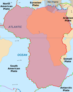
The African Plate is a major tectonic plate straddling the Equator as well as the prime meridian. It includes much of the continent of Africa, as well as oceanic crust which lies between the continent and various surrounding ocean ridges. Between 60 million years ago and 10 million years ago, the Somali Plate began rifting from the African Plate along the East African Rift. Since the continent of Africa consists of crust from both the African and the Somali plates, some literature refers to the African Plate as the Nubian Plate to distinguish it from the continent as a whole.

<span class="mw-page-title-main">Rift</span> Geological linear zone where the lithosphere is being pulled apart

In geology, a rift is a linear zone where the lithosphere is being pulled apart and is an example of extensional tectonics.

<span class="mw-page-title-main">Somali Plate</span> Minor tectonic plate including the east coast of Africa and the adjoining seabed

The Somali Plate is a minor tectonic plate which straddles the Equator in the Eastern Hemisphere. It is currently in the process of separating from the African Plate along the East African Rift Valley. It is approximately centered on the island of Madagascar and includes about half of the east coast of Africa, from the Gulf of Aden in the north through the East African Rift Valley. The southern boundary with the Nubian-African Plate is a diffuse plate boundary consisting of the Lwandle Plate.

<span class="mw-page-title-main">East African Rift</span> Active continental rift zone in East Africa

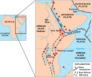
The East African Rift (EAR) or East African Rift System (EARS) is an active continental rift zone in East Africa. The EAR began developing around the onset of the Miocene, 22–25 million years ago. In the past it was considered to be part of a larger Great Rift Valley that extended north to Asia Minor.

<span class="mw-page-title-main">Afar Triangle</span> Geological depression caused by the Afar Triple Junction

The Afar Triangle is a geological depression caused by the Afar Triple Junction, which is part of the Great Rift Valley in East Africa. The region has disclosed fossil specimens of the very earliest hominins; that is, the earliest of the human clade, and it is thought by some paleontologists to be the cradle of the evolution of humans; see Middle Awash, Hadar. The Depression overlaps the borders of Eritrea, Djibouti and the entire Afar Region of Ethiopia; and it contains the lowest point in Africa, Lake Assal, Djibouti, at 155 m below sea level.

<span class="mw-page-title-main">Terceira Rift</span> Geological plate boundary

The Terceira Rift is a geological rift located amidst the Azores islands in the Atlantic Ocean. It runs between the Azores Triple Junction to the west and the Azores–Gibraltar Transform Fault to the southeast. It separates the Eurasian Plate to the north from the African Plate to the south. The Terceira Rift is named for Terceira Island through which it passes. It crosses Terceira Island as a prominent ESE-WNW fissure zone.

<span class="mw-page-title-main">Red Sea Rift</span> Oceanic rift between the African and Arabian Plates

The Red Sea Rift is a spreading center between two tectonic plates, the African Plate and the Arabian Plate. It extends from the Dead Sea Transform fault system, and ends at an intersection with the Aden Ridge and the East African Rift, forming the Afar Triple Junction in the Afar Depression of the Horn of Africa.

<span class="mw-page-title-main">Aden Ridge</span> Part of an active oblique rift system in the Gulf of Aden, between Somalia and the Arabian Peninsula

The Aden Ridge is a part of an active oblique rift system located in the Gulf of Aden, between Somalia and the Arabian Peninsula to the north. The rift system marks the divergent boundary between the Somali and Arabian tectonic plates, extending from the Owen Transform Fault in the Arabian Sea to the Afar Triple Junction or Afar Plume beneath the Gulf of Tadjoura in Djibouti.

The Aden-Owen-Carlsberg Triple Junction (AOC), also known as the Arabia–India–Somalia Triple Junction, is a triple junction that connects the Aden Ridge, Owen Fracture Zone, and Carlsberg Ridge in the northwest Indian Ocean. It has been described as one of only three RRF (ridge-ridge-fault) triple junctions on Earth, besides the Azores Triple Junction and Chile Triple Junction. However, because the fault arm of such unstable triple junctions tend to evolve into a spreading centre, all three cases have quickly evolved into stable RRR triple junctions.

<span class="mw-page-title-main">Southwest Indian Ridge</span> A mid-ocean ridge on the bed of the south-west Indian Ocean and south-east Atlantic Ocean

The Southwest Indian Ridge (SWIR) is a mid-ocean ridge located along the floors of the south-west Indian Ocean and south-east Atlantic Ocean. A divergent tectonic plate boundary separating the Somali Plate to the north from the Antarctic Plate to the south, the SWIR is characterised by ultra-slow spreading rates combined with a fast lengthening of its axis between the two flanking triple junctions, Rodrigues in the Indian Ocean and Bouvet in the Atlantic Ocean.

This is a list of articles related to plate tectonics and tectonic plates.

The Madagascar Plate or Madagascar block is a tectonic plate holding the island of Madagascar. It was once attached to the Gondwana supercontinent and later the Indo-Australian Plate.

<span class="mw-page-title-main">Great Rift Valley, Ethiopia</span> Branch of the East African Rift that runs through Ethiopia

The Great Rift Valley of Ethiopia, is a branch of the East African Rift that runs through Ethiopia in a southwest direction from the Afar Triple Junction. In the past, it was seen as part of a "Great Rift Valley" that ran from Mozambique to Syria.

<span class="mw-page-title-main">Gregory Rift</span>

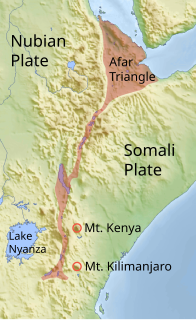
The Gregory Rift is the eastern branch of the East African Rift fracture system. The rift is being caused by the separation of the Somali plate from the Nubian plate, driven by a thermal plume. Although the term is sometimes used in the narrow sense of the Kenyan Rift, the larger definition of the Gregory Rift is the set of faults and grabens extending southward from the Gulf of Aden through Ethiopia and Kenya into Northern Tanzania, passing over the local uplifts of the Ethiopian and Kenyan domes. Ancient fossils of early hominins, the ancestors of humans, have been found in the southern part of the Gregory Rift.

<span class="mw-page-title-main">Opening of the North Atlantic Ocean</span> Breakup of Pangea

The opening of the North Atlantic Ocean is a geological event that has occurred over millions of years, during which the supercontinent Pangea broke up. As modern-day Europe and North America separated during the final breakup of Pangea in the early Cenozoic Era, they formed the North Atlantic Ocean. Geologists believe the breakup occurred either due to primary processes of the Iceland plume or secondary processes of lithospheric extension from plate tectonics.

<span class="mw-page-title-main">Adare Basin</span>

The Adare Basin is a geologic structural basin located north-east of Cape Adare of Antarctica, for which its named, and north of the western Ross Sea. The Adare Basin is an extensional rift basin located along a seafloor spreading center that forms the failed arm of the Tertiary spreading ridge separating East and West Antarctica, known as the West Antarctic Rift System and similar in structure to the East Africa Rift System. Centrally located in the Adare Basin is the Adare Trough. The extension of this rift system is recorded in a series of magnetic anomalies which run along the seafloor at the extinct, north–south trending, Adare spreading axis. The Adare spreading system continues unbroken into the Northern Basin underlying the adjacent Ross Sea continental shelf.

The geology of Socotra is part of the national geology of Yemen. Ancient Precambrian metamorphic rocks are intruded by younger igneous rocks, overlain by limestones and other marine sediments that deposited during marine transgression periods in the Cretaceous and the past 66 million years of the Cenozoic. The island is on the Somali Plate, which rifted away from the Arabian mainland within the past 60 million years.

References

  1. 1 2 3 4 5 6 Chorowicz, Jean (1 October 2005). "The East African rift system". Journal of African Earth Sciences. 43 (1–3): 379–410. Bibcode:2005JAfES..43..379C. doi:10.1016/j.jafrearsci.2005.07.019.
  2. Gani, Nahid D. S.; Gani, M. Royhan; Abdelsalam, Mohamed G. (September 2007). "Blue Nile incision on the Ethiopian Plateau: Pulsed plateau growth, Pliocene uplift, and hominin evolution". GSA Today. 17 (9): 4. doi: 10.1130/GSAT01709A.1 .
  3. Baker, B. H.; Mohr, P. A.; Williams, L. A. J. (1972). Geology of the eastern rift system of Africa. Boulder, Colorado: Geological Society of America. ISBN   0813721369.
  4. 1 2 Beyene, Alebachew; Abdelsalam, Mohamed G. (1 January 2005). "Tectonics of the Afar Depression: A review and synthesis". Journal of African Earth Sciences. 41 (1–2): 41–59. Bibcode:2005JAfES..41...41B. doi:10.1016/j.jafrearsci.2005.03.003.
  5. Waltham, Tony (2005). "Extension tectonics in the Afar Triangle". Geology Today. 21 (3): 101–107. doi:10.1111/j.1365-2451.2005.00510.x. S2CID   128970545.
  6. Ebinger, Cynthia; et al. (2010). "Length and Timescales of Rift Faulting and Magma Intrusion: The Afar Rifting Cycle from 2005 to Present". Annual Review of Earth and Planetary Sciences. 38 (1): 439–466. Bibcode:2010AREPS..38..439E. doi:10.1146/annurev-earth-040809-152333. hdl: 2158/1110108 .
  7. Leroy, Sylvie; d'Acremont, Elia; Tiberi, Christel; Basuyau, Clémence; Autin, Julia; Lucazeau, Francis; Sloane, Heather (2010). "Recent off-axis volcanism in the eastern Gulf of Aden; implications for plume-ridge interaction" (PDF). Earth and Planetary Science Letters. 293 (1–2): 140–153. Bibcode:2010E&PSL.293..140L. doi:10.1016/j.epsl.2010.02.036.
  8. Grand, Stephen; van der Hilst, Rob D.; Widiyantoro, Sri (April 1997). "Global Seismic Tomography: A Snapshot of Convection in the Earth". GSA Today. 7 (4): 1.