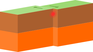
A transform fault or transform boundary, sometimes called a strike-slip boundary, is a fault along a plate boundary where the motion is predominantly horizontal. It ends abruptly where it connects to another plate boundary, either another transform, a spreading ridge, or a subduction zone. A transform fault is a special case of a strike-slip fault that also forms a plate boundary.

Sedimentary basins are regions of the Earth where long-term subsidence creates accommodation space for accumulation of sediments. As the sediments are buried, they are subject to increasing pressure and begin the processes of compaction and lithification that transform them into sedimentary rock.

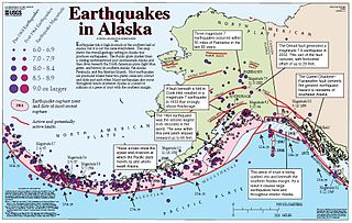
The North American Plate is a tectonic plate covering most of North America, Cuba, the Bahamas, extreme northeastern Asia, and parts of Iceland and the Azores. With an area of 76 million km2 (29 million sq mi), it is the Earth's second largest tectonic plate, behind the Pacific Plate.

The Juan de Fuca Plate is a small tectonic plate (microplate) generated from the Juan de Fuca Ridge that is subducting under the northerly portion of the western side of the North American Plate at the Cascadia subduction zone. It is named after the explorer of the same name. One of the smallest of Earth's tectonic plates, the Juan de Fuca Plate is a remnant part of the once-vast Farallon Plate, which is now largely subducted underneath the North American Plate.
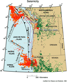
The Gorda Plate, located beneath the Pacific Ocean off the coast of northern California, is one of the northern remnants of the Farallon Plate. It is sometimes referred to as simply the southernmost portion of the neighboring Juan de Fuca Plate, another Farallon remnant.
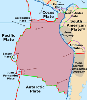
The Nazca Plate or Nasca Plate, named after the Nazca region of southern Peru, is an oceanic tectonic plate in the eastern Pacific Ocean basin off the west coast of South America. The ongoing subduction, along the Peru–Chile Trench, of the Nazca Plate under the South American Plate is largely responsible for the Andean orogeny. The Nazca Plate is bounded on the west by the Pacific Plate and to the south by the Antarctic Plate through the East Pacific Rise and the Chile Rise respectively. The movement of the Nazca Plate over several hotspots has created some volcanic islands as well as east-west running seamount chains that subduct under South America. Nazca is a relatively young plate both in terms of the age of its rocks and its existence as an independent plate having been formed from the break-up of the Farallon Plate about 23 million years ago. The oldest rocks of the plate are about 50 million years old.

The Pacific Plate is an oceanic tectonic plate that lies beneath the Pacific Ocean. At 103 million km2 (40 million sq mi), it is the largest tectonic plate.

The Explorer Plate is an oceanic tectonic plate beneath the Pacific Ocean off the west coast of Vancouver Island, Canada, which is partially subducted under the North American Plate. Along with the Juan De Fuca Plate and Gorda Plate, the Explorer Plate is a remnant of the ancient Farallon Plate, which has been subducted under the North American Plate. The Explorer Plate separated from the Juan De Fuca Plate roughly 4 million years ago. In its smoother, southern half, the average depth of the Explorer plate is roughly 2,400 metres (7,900 ft) and rises up in its northern half to a highly variable basin between 1,400 metres (4,600 ft) and 2,200 metres (7,200 ft) in depth.

The Cascadia subduction zone is a convergent plate boundary that stretches from northern Vancouver Island in Canada to Northern California in the United States. It is a very long, sloping subduction zone where the Explorer, Juan de Fuca, and Gorda plates move to the east and slide below the much larger mostly continental North American Plate. The zone varies in width and lies offshore beginning near Cape Mendocino, Northern California, passing through Oregon and Washington, and terminating at about Vancouver Island in British Columbia.

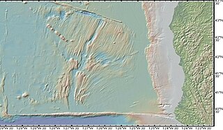
A fracture zone is a linear oceanic feature—often hundreds, even thousands of kilometers long—resulting from the action of offset mid-ocean ridge axis segments. They are a consequence of plate tectonics. Lithospheric plates on either side of an active transform fault move in opposite directions; here, strike-slip activity occurs. Fracture zones extend past the transform faults, away from the ridge axis; seismically inactive, they display evidence of past transform fault activity, primarily in the different ages of the crust on opposite sides of the zone.

The Mendocino Triple Junction (MTJ) is the point where the Gorda plate, the North American plate, and the Pacific plate meet, in the Pacific Ocean near Cape Mendocino in northern California. This triple junction is the location of a change in the broad plate motions which dominate the west coast of North America, linking convergence of the northern Cascadia subduction zone and translation of the southern San Andreas Fault system. The Gorda plate is subducting, towards N50ºE, under the North American plate at 2.5 – 3 cm/yr, and is simultaneously converging obliquely against the Pacific plate at a rate of 5 cm/yr in the direction N115ºE. The accommodation of this plate configuration results in a transform boundary along the Mendocino Fracture Zone, and a divergent boundary at the Gorda Ridge.
The Gorda Ridge, aka Gorda Ridges tectonic spreading center, is located roughly 200 kilometres (120 mi) off the northern coast of California and southern Oregon. Running NE – SW it is roughly 300 kilometres (190 mi) in length. The ridge is broken into three segments; the northern ridge, central ridge, and the southern ridge, which contains the Escanaba Trough.

The Blanco Fracture Zone or Blanco Transform Fault Zone (BTFZ) is a right lateral transform fault zone, which runs northeast off the coast of Oregon in the Pacific Northwest of the United States, extending from the Gorda Ridge in the south to the Juan de Fuca Ridge in the north.
The Queen Charlotte Fault is an active transform fault that marks the boundary of the North American and the Pacific Plates. It is Canada's right-lateral strike-slip equivalent to the San Andreas Fault to the south in California. The Queen Charlotte Fault forms a triple junction on its south with the Cascadia subduction zone and the Explorer Ridge.

The Explorer Ridge is a mid-ocean ridge, a divergent tectonic plate boundary located about 241 km (150 mi) west of Vancouver Island, British Columbia, Canada. It lies at the northern extremity of the Pacific spreading axis. To its east is the Explorer Plate, which together with the Juan de Fuca Plate and the Gorda Plate to its south, is what remains of the once-vast Farallon Plate which has been largely subducted under the North American Plate. The Explorer Ridge consists of one major segment, the Southern Explorer Ridge, and several smaller segments. It runs northward from the Sovanco Fracture Zone to the Queen Charlotte Triple Junction, a point where it meets the Queen Charlotte Fault and the northern Cascadia subduction zone.

The Macquarie Triple Junction is a geologically active tectonic boundary located at 61°30′S161°0′E at which the Indo-Australian Plate, Pacific Plate, and Antarctic Plate collide and interact. The term Triple Junction is given to particular tectonic boundaries at which three separate tectonic plates meet at a specific, singular location. The Macquarie Triple Junction is located on the seafloor of the southern region of the Pacific Ocean, just south of New Zealand. This tectonic boundary was named in respect to the nearby Macquarie Island, which is located southeast of New Zealand.
This is a list of articles related to plate tectonics and tectonic plates.

The Pacific Ocean evolved in the Mesozoic from the Panthalassic Ocean, which had formed when Rodinia rifted apart around 750 Ma. The first ocean floor which is part of the current Pacific Plate began 160 Ma to the west of the central Pacific and subsequently developed into the largest oceanic plate on Earth.

The Leech River Fault extends across the southern tip of Vancouver Island in British Columbia, Canada, creating the distinctively straight, narrow, and steep-sided valley, occupied by Loss Creek and two reservoirs, that runs from Sombrio Point due east to the Leech River, and then turns southeast to run past Victoria. It is a thrust fault that marks the northernmost exposure of the Crescent Terrane, where basalt of the Metchosin Igneous Complex is dragged under Vancouver Island by the subducting Juan de Fuca Plate. About ten kilometers north the nearly parallel San Juan Fault marks the southern limit of rock of the Wrangellia terrane, which underlies most of Vancouver Island. Between these two northeast-dipping thrust faults are the Leech River Complex and the Pandora Peak Unit. These, along with the Pacific Rim Complex further up the coast, are remnants of the Pacific Rim Terrane which was crushed between Wrangellia and Siletzia. The contact between the bottom of Wrangellia and the top of the subducted PRT continues northwest along the coast as the West Coast Fault, and southeast towards Victoria as the Survey Mountain Fault. The Leach River Fault (LRF) extends off-shore towards Cape Flattery, where the Crescent—Pacific Rim contact continues northwest as the Tofino Fault (TF).
