Toyah, Texas

Last updated

Toyah, Texas
Abandoned school in Toyah, Texas.jpg
Historic high school in Toyah
TXMap-doton-Toyah.PNG
Location of Toyah, Texas
Reeves County Toyah.svg
Coordinates: 31°18′48″N103°47′35″W / 31.31333°N 103.79306°W / 31.31333; -103.79306
Country United States
State Texas
County Reeves
Government
  MayorBobby Creamer
Area
[1]
  Total1.62 sq mi (4.20 km2)
  Land1.62 sq mi (4.20 km2)
  Water0.00 sq mi (0.00 km2)
Elevation
2,913 ft (888 m)
Population
 (2010)
  Total61
  Estimate 
(2019) [2]
108
  Density66.54/sq mi (14.52/km2)
Time zone UTC-6 (Central (CST))
  Summer (DST) UTC-5 (CDT)
ZIP code
79785
Area code 432
FIPS code 48-73496 [3]
GNIS feature ID1370063 [4]

Toyah is a town in Reeves County, Texas, United States. The population was 61 in the 2010 census.

Contents

History

On October 25, 1906 [5] a black man in Toyah named J.I. "Slab" Pitts was dragged to death and then hanged for living with his white wife, Eva Ruff. [6] [5]

In September 1928, Amelia Earhart made an unscheduled five-day stop to adjust her carburetor. She relates in her journal that she landed in a small town near Pecos, Texas, but according to a regional book, The Toyah Taproots, several local, unnamed youngsters were seen in pictures around her airplane were later identified as being from Toyah. [7]

Much of the town was destroyed by a tornado in 2004. Several abandoned homes, a deserted volunteer fire department and forgotten cars sit on the empty streets. Toyah High School also remains.[ citation needed ]

Geography

According to the United States Census Bureau, the town has a total area of 1.6 square miles (4.1 km2), all land.

Demographics

Historical population
CensusPop.Note
1910 1,052
1930 553
1940 464−16.1%
1950 409−11.9%
1960 294−28.1%
1970 245−16.7%
1980 165−32.7%
1990 115−30.3%
2000 100−13.0%
2010 90−10.0%
2020 61−32.2%
U.S. Decennial Census [8]

At the 2000 census there were 100 people, 47 households, and 28 families living in the town. The population density was 61.6 inhabitants per square mile (23.8/km2). There were 72 housing units at an average density of 44.3 per square mile (17.1/km2). The racial makeup of the town was 84.00% White, 4.00% African American, 2.00% Native American, 4.00% from other races, and 6.00% from two or more races. Hispanic or Latino people of any race were 51.00%. [3]

Of the 47 households 14.9% had children under the age of 18 living with them, 51.1% were married couples living together, 4.3% had a female householder with no husband present, and 38.3% were non-families. 36.2% of households were one person and 19.1% were one person aged 65 or older. The average household size was 2.13 and the average family size was 2.79.

The age distribution was 13.0% under the age of 18, 8.0% from 18 to 24, 24.0% from 25 to 44, 27.0% from 45 to 64, and 28.0% 65 or older. The median age was 48 years. For every 100 females, there were 138.1 males. For every 100 females age 18 and over, there were 128.9 males.

The median household income was $16,500 and the median family income was $15,313. Males had a median income of $19,375 versus $11,250 for females. The per capita income for the town was $8,611. There were 47.8% of families and 52.9% of the population living below the poverty line, including 100.0% of under 18 and 22.2% of those over 64.

Education

The Town of Toyah is served by the Pecos-Barstow-Toyah Independent School District.

Related Research Articles

<span class="mw-page-title-main">San Miguel County, New Mexico</span> County in New Mexico, United States

San Miguel County is a county in the U.S. state of New Mexico. As of the 2020 census, the population was 27,201. Its county seat is Las Vegas.

<span class="mw-page-title-main">Eddy County, New Mexico</span> County in New Mexico, United States

Eddy County is a county located in the U.S. state of New Mexico. As of the 2020 census, the population was 62,314. Its county seat and largest city is Carlsbad. The county was created in 1891 and later organized in 1892. It is north of the Texas state line.

<span class="mw-page-title-main">Jennings, Kansas</span> City in Decatur County, Kansas

Jennings is a city in Decatur County, Kansas, United States. As of the 2020 census, the population of the city was 81.

Amelia is a census-designated place (CDP) in St. Mary Parish, Louisiana, United States. The population was 2,459 at the 2010 census. It is part of the Morgan City Micropolitan Statistical Area.

Meddybemps is a town in Washington County, Maine, United States. The population was 139 at the 2020 census.

<span class="mw-page-title-main">Urbank, Minnesota</span> City in Minnesota, United States

Urbank is a city in Otter Tail County, Minnesota, United States. The population was 52 at the 2020 census.

<span class="mw-page-title-main">Dexter, New Mexico</span> Town in New Mexico, United States

Dexter is a town in Chaves County, New Mexico, United States. The population was 1,266 at the time of the 2010 census.

<span class="mw-page-title-main">Paradise Hill, Oklahoma</span> Town in Oklahoma, United States

Paradise Hill is a town in the northwest corner of Sequoyah County, Oklahoma, United States. It is part of the Fort Smith, Arkansas-Oklahoma Metropolitan Statistical Area. The population was 85 at the 2010 census, a decline from the figure of 100 recorded in 2000.

<span class="mw-page-title-main">Yale, South Dakota</span> Town in South Dakota, United States

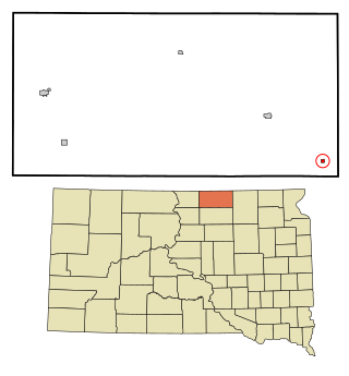
Yale is an incorporated town in Beadle County, South Dakota, United States. The population was 112 at the 2020 census.

<span class="mw-page-title-main">Wetonka, South Dakota</span> Town in South Dakota, United States

Wetonka is a town in McPherson County, South Dakota, United States. The population was 16 at the 2020 census.

<span class="mw-page-title-main">Coyanosa, Texas</span> Village in Texas, United States

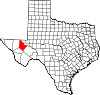
Coyanosa is an unincorporated desert village in Pecos County, located in the Permian Basin in West Texas, United States. Its population was 155 at the 2020 census. Part of the Coyanosa Draw runs adjacent to the town, 2.2 miles to the west. There is a food store, two Mexican restaurants, a public library, an RV park and a post office at Coyanosa by way of businesses and services.

<span class="mw-page-title-main">Pecos, Texas</span> City in Texas, United States

Pecos is the largest city in and the county seat of Reeves County, Texas, United States. It is in the valley on the west bank of the Pecos River at the eastern edge of the Chihuahuan Desert, in the Trans-Pecos region of West Texas and just south of New Mexico's border. Its population was 12,916 at the 2020 census. On January 24, 2012, Pecos City appeared on the Forbes 400 as the second-fastest growing small town in the United States. The city is a regional commercial center for ranching, oil and gas production, and agriculture. The city is most recognized for its association with the local cultivation of cantaloupes. Pecos claims to be the site of the world's first rodeo on July 4, 1883.

<span class="mw-page-title-main">Barstow, Texas</span> City in Texas, United States

Barstow is a city in Ward County, in the U.S. state of Texas. The population was 265 at the 2020 census.

<span class="mw-page-title-main">Elmer City, Washington</span> Town in Washington, United States

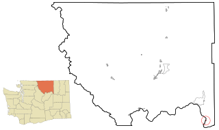
Elmer City is a town in Okanogan County, Washington, United States. The population was 238 at the 2010 census.

<span class="mw-page-title-main">South Prairie, Washington</span> Town in Washington, United States

South Prairie is a town in Pierce County, Washington, United States. The population was 373 at the 2020 census.

<span class="mw-page-title-main">Oakesdale, Washington</span> Town in Washington, United States

Oakesdale is a town in Whitman County, Washington, United States. The population was 422 at the 2010 census.

<span class="mw-page-title-main">Bruceton Mills, West Virginia</span> Town in West Virginia, United States

Bruceton Mills is a town in northern Preston County, West Virginia, United States, along Big Sandy Creek. The population was 64 at the 2020 census, making it the second-least populous town in West Virginia, after Thurmond. It is part of the Morgantown metropolitan area.

<span class="mw-page-title-main">Bancroft, West Virginia</span> Town in West Virginia, United States

Bancroft is a town in Putnam County, West Virginia, United States, along the Kanawha River. The population was 389 at the 2020 census. It is part of the Huntington–Ashland metropolitan area.

<span class="mw-page-title-main">Cairo, West Virginia</span> Town in West Virginia, United States

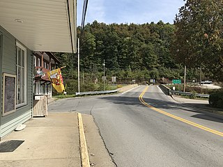
Cairo is a town in Ritchie County, West Virginia, United States, along West Virginia Route 31, the North Fork of the Hughes River, and the North Bend Rail Trail. The population was 174 at the 2020 census.

<span class="mw-page-title-main">Genesee, Wisconsin</span> Town in Wisconsin, United States

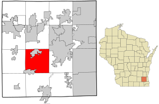
Genesee is a town in Waukesha County, Wisconsin, United States. The population was 7,171 at the 2020 census. The unincorporated communities of Bethesda, Genesee, Genesee Depot, and Saylesville are in the town.

References

  1. "2019 U.S. Gazetteer Files". United States Census Bureau. Retrieved August 7, 2020.
  2. "Population and Housing Unit Estimates". United States Census Bureau. May 24, 2020. Retrieved May 27, 2020.
  3. 1 2 "U.S. Census website". United States Census Bureau . Retrieved January 31, 2008.
  4. "US Board on Geographic Names". United States Geological Survey. October 25, 2007. Retrieved January 31, 2008.
  5. 1 2 "Lynching of "Slab" Pitts" . Retrieved November 29, 2019.
  6. Last, Anne M. (September 10, 2015). "Strange Fruit and Spanish Moss: October 26, 1906: "Slab" Pitt". Strange Fruit and Spanish Moss. Retrieved December 6, 2019.
  7. "Amelia Earhart in Toyah TX".
  8. "Census of Population and Housing". Census.gov. Retrieved June 4, 2015.