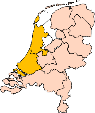
Holland is a geographical region and former province on the western coast of the Netherlands. From the 10th to the 16th century, Holland proper was a unified political region within the Holy Roman Empire as a county ruled by the counts of Holland. By the 17th century, the province of Holland had risen to become a maritime and economic power, dominating the other provinces of the newly independent Dutch Republic.
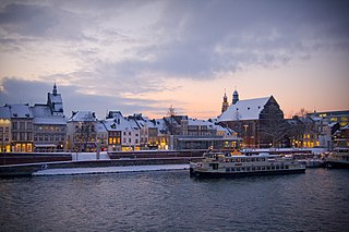
Maastricht is a city and a municipality in the southeastern Netherlands. It is the capital and largest city of the province of Limburg. Maastricht is located on both sides of the Meuse, at the point where the Jeker joins it. Mount Saint Peter (Sint-Pietersberg) is largely situated within the city's municipal borders. Maastricht is adjacent to the border with Belgium and is part of the Meuse-Rhine Euroregion, an international metropolis with a population of about 3.9 million, which includes the nearby German and Belgian cities of Aachen, Liège, and Hasselt.

Utrecht is the fourth-largest city of the Netherlands, as well as the capital and the most populous city of the province of Utrecht. The municipality of Utrecht is located in the eastern part of the Randstad conurbation, in the very centre of mainland Netherlands, and includes Haarzuilens, Vleuten en De Meern. It has a population of 361,699 as of December 2021.
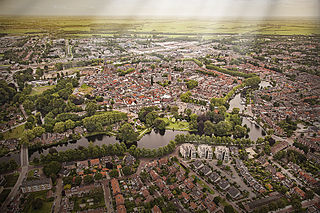
Woerden is a city and a municipality in central Netherlands. Due to its central location between Amsterdam, Rotterdam, The Hague, and Utrecht, and the fact that it has rail and road connections to those cities, it is a popular town for commuters who work in those cities.

In the Roman Republic and the Roman Empire, the Latin word castrum was a military-related term.

Waterzooi is a stew dish from Belgium and originating in Flanders. The second part of the name derives from the Middle Dutch terms sode, zo(o)de and soot, words referring to the act of boiling or the ingredients being boiled. It is sometimes called Gentse Waterzooi which refers to the Belgian town of Ghent where it originated. The original dish is often made of fish, either freshwater or sea,, though today chicken waterzooi (Kippenwaterzooi) is more common. The most accepted theory is that rivers around Ghent became too polluted and the fish there disappeared. Charles V, Holy Roman Emperor ate the rich dish, even after suffering from gout.

Brabantian or Brabantish, also Brabantic or Brabantine, is a dialect group of the Dutch language. It is named after the historical Duchy of Brabant, which corresponded mainly to the Dutch province of North Brabant, the Belgian provinces of Antwerp and Flemish Brabant as well as the Brussels-Capital Region and the province of Walloon Brabant. Brabantian expands into small parts in the west of Limburg, and its strong influence on the Flemish dialects in East Flanders weakens toward the west. In a small area in the northwest of North Brabant (Willemstad), Hollandic is spoken. Conventionally, the Kleverlandish dialects are distinguished from Brabantian, but for no reason other than geography.
Dutch Low Saxon are the Low Saxon dialects of the Low German language that are spoken in the northeastern Netherlands and are written there with local, unstandardised orthographies based on Standard Dutch orthography.

Loosduinen is a former village in the Netherlands that was a municipality unto itself until 1923, when it was annexed by The Hague and subsequently became a district of the city.

Bremetennacum,, or Bremetennacum Veteranorum, was a Roman fort on the site of the present day village of Ribchester in Lancashire, England. The site is a Scheduled Monument.

Bible translations into Dutch have a history that goes back to the Middle Ages. The oldest extant Bible translations into the Dutch language date from the Middle Dutch (Diets) period.

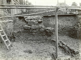
Fectio, known as Vechten in Old Dutch, was a Roman castellum in the province Germania Inferior established in the year 4 or 5 AD. It was located at the place where the river Vecht (Fectio) branched off from the Rhine, leading to Lake Flevo, which was later to become the Zuiderzee. This was near the modern hamlet of Vechten in the municipality Bunnik, Utrecht, Netherlands.

Johannes Voet, also known as John Voet, was a Dutch jurist whose work remains highly influential in modern Roman-Dutch law.
Dutch profanity can be divided into several categories. Often, the words used in profanity by speakers of Dutch are based around various names for diseases. In many cases, these words have evolved into slang, and many euphemisms for diseases are in common use.
Praetorium Agrippinae was a Roman settlement in the province of Lower Germania, in the area of the Cananefates, located in modern-day Valkenburg, Netherlands. It was an army encampment on the Old Rhine, on the northern border of the Roman Empire, the limes. Praetorium Agrippinae is mentioned on the Tabula Peutingeriana between the castella of Matilo in the east and Lugdunum Batavorum to the west.
Albaniana was the name the ancient Romans gave a settlement on the southern banks of Rhine river, some 40 kilometers from its mouth in the North Sea, known as Alfen and modern-day Alphen aan den Rijn, Netherlands. They did build a military fort there, as part of a range strategically built encampments, to protect and guard the river, frontier (limes) of the Roman empire and main transport route of goods and troops. The historical map Tabula Peutingeriana situates the settlement in between Matilo (Leiden) and Praetorium Agrippinae (Valkenburg) downstream and Nigrum Pullum (Zwammerdam) and Fectio (Vechten) upstream. The village was mentioned in Antoninus' register of roads Itinerarium Antonini from the 3rd century. The fortress must have been surrounded by a wall of ground and wooden poles, with gates and watch towers.

The Duitse Huis is a complex of buildings in the city of Utrecht, Netherlands, protected as a national monument. The older parts date to a monastery of the Bailiwick of Utrecht of the Teutonic Knights founded in 1348. Originally Catholic, the order became Protestant during the Reformation. A military hospital was added in 1823 after the knights had sold the property. The property was sold back to the Bailiwick of Utrecht and a major renovation started in 1992. Some of the older buildings are again the headquarters of the Bailiwick of Utrecht, now a charity, and hold an important collection of medieval manuscripts, coins and pictures. Other buildings, including the former hospital, have been converted into a five-star hotel, the Grand Hotel Karel V.
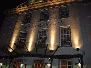
The Grand Hotel Karel V is a hotel in Utrecht, Netherlands. It is located in the Duitse Huis complex of buildings, including part of the old monastery of the Bailiwick of Utrecht of the Teutonic Knights founded in 1348. Most of the rooms and suites are in a former military hospital, which dates from 1823 and has been carefully renovated, or in the modern Roman wing opened in 2008. The hotel contains a Roman-themed health center, conference rooms, a bar, brasserie and the Grand Restaurant Karel V. It is set in extensive grounds.
The following is a timeline of the history of the municipality of Utrecht, Netherlands.

Karel van der Hucht is a Dutch astronomer.