Transport in Sydney

Last updated

TfNSW M.svg
TfNSW T.svg
TfNSW B.svg
TfNSW F.svg
TfNSW L.svg
The TfNSW public transport roundels used in Sydney. Left to right: metro, train, bus, ferry, light rail
The Grand Concourse of Central station; a major hub for public transport services Central Station Concourse Hall.jpg
The Grand Concourse of Central station; a major hub for public transport services
Light Horse Interchange, the largest of its kind in Australia Light Horse Interchange (aerial view).jpg
Light Horse Interchange, the largest of its kind in Australia

Transport in Sydney is provided by an extensive network of public transport operating modes including metro, train, bus, ferry and light rail, as well as an expansive network of roadways, cycleways and airports. According to the 2006 census, in terms of travel to work or study Sydney has the highest rate of public transport usage among the Australian capital cities of 26.3% with more than 80% of weekday trips to/from Central Sydney being made by public transport. [1] According to the New South Wales State Plan, the state has Australia's largest public transport system. The public transport network is regulated by Transport for NSW.

Contents

History

Sydney's early urban sprawl can be traced in part to the development of its passenger rail network as well as the availability of the automobile as the dominant mode of transporta similar history has shaped the transport and infrastructure of most major Australian cities. [2] The first rail services began in 1855, 67 years after the settlement's foundation and a tram network which began in 1861, becoming the Southern Hemisphere's largest by the 1920s. This rail infrastructure allowed working-class suburbs to develop at a large distance from the city centre. [2] In terms of effectiveness and sustainability of public transport, Sydney lagged behind Brisbane and many other cities in a 2017 study by design firm Arcadis, where it was ranked at 51. [3] [4]

Ticketing

Opal card readers SydneyMetro19.jpg
Opal card readers

Transport for NSW public transport services use the Opal ticketing system. The rollout of this contactless system started in December 2012 and completed in December 2014. The previous generation of ticketing products were withdrawn in August 2016. Fares are set by the Government of New South Wales. As of January 2009, Sydney public transport prices were slightly higher than in other mainland Australian cities. [5]

Bus

A State Transit Authority bus. Transport NSW liveried (2601 ST), operated by Sydney Buses, Bustech VST bodied Scania K280UB.jpg
A State Transit Authority bus.
Buses replace trams on George Street, 1962. Buses replace trams, c.1962 (2742915440).jpg
Buses replace trams on George Street, 1962.

Commuter bus services account for about half of the public transport journeys taken in the city on weekdays. Services are provided by private sector operators under contract to Transport for NSW. [6]

The largest private bus operator is CDC NSW. Other significant players include Busways and Transit Systems

Network

Sydney's bus network has been divided into different regions. Of these regions, bus routes are classified with three-digit route numbers.

Currently, Sydney has two operating T-Ways:

Rail

A Sydney Trains B set. B set departing Flemington 20181031 (cropped).jpg
A Sydney Trains B set.

Commuter Rail

Suburban rail services within Sydney are provided by Sydney Trains. Sydney's suburban commuter rail service consists of a complex system of integrated railway lines, of which most run through the city underground. All city trains consist of eight double deck carriages with two crew members on boarddriver and guard. Fares are calculated on the basis of distance travelled. Trains run from 4am until around 1am seven days a week with Nightride bus services covering the network throughout the night when trains are not operating.

An XPT long-distance train operated by NSW TrainLink NSW TrainLink XPT Jindalee - Morrisons Hill (cropped).jpg
An XPT long-distance train operated by NSW TrainLink

NSW TrainLink interurban trains operate from Central railway station to the Illawarra, Southern Highlands, Blue Mountains, Central Coast and Newcastle. This station is also the terminus for NSW TrainLink's long-distance trains to numerous destinations in country New South Wales as well as Melbourne and Brisbane. The Indian Pacific also operates to Adelaide and Perth.

Rapid Transit (Metro)

A fully automated Alstom Metropolis train on the Sydney Metro system. Sydney Metro opening day Tallawong.png
A fully automated Alstom Metropolis train on the Sydney Metro system.

Sydney Metro is a rapid transit line that opened in 2019 and runs from Sydney's north-western suburbs to its terminus at Chatswood, a major transport interchange. Construction is currently underway for the second phase of the line, where it will eventually pass through the city and then travel south-west to Bankstown. It currently consists of 13 stations and 36 km (22.4 mi) of twin tracks, mostly underground. Work is progressing to extend this line from Chatswood to Bankstown, running under Sydney Harbour and the CBD with a scheduled 2025 completion. When completed, this line will have 66 km (41.0 mi) of twin tracks and 31 stations in total.

Sydney is the first and currently the only Australian city with a fully automated rapid transit metro system. [7] [8] Despite extensive plans for an underground network in the past, disputes over privatisation and funding had hampered government approval, delaying its inception. In spite of difficulties getting the project off the ground, government approval for what was initially known as the North West Rail Link, Sydney's first underground metro, was given in 2013.

Freight

A Pacific National freight train Goods train - panoramio.jpg
A Pacific National freight train

Freight services operate over most of the suburban railway lines in Sydney, however due to the high frequency of passenger services and the lack of freight only tracks, there is a curfew on freight movements during peak hours. [9]

The major interstate freight routes are the Main Southern and Main North lines, with the Illawarra and Main Western lines serving lineside industries and as alternate interstate routes. In the inner city area the Metropolitan Goods line connects major freight terminals to the main passenger lines and the Southern Sydney Freight Line which runs parallel to the Main South line from the western end of the Metropolitan Goods lines to a point beyond the end of suburban services. [10] The Northern Sydney Freight Corridor was completed in 2016. This was a series of projects along the Main Northern line between Sydney and Newcastle aimed at increasing the number of freight trains operating along the route.

The main traffic is containerised freight. The main intermodal terminals are at Enfield, Moorebank, Yennora and Minto. [11] [12] [13] Interstate trains to Sydney terminals are up to 1500 metres long, while short-haul container trains from the terminals to the Port Botany seaport are around 600 metres long. [9] Coal services to Port Kembla are another major traffic. Freight operators include Aurizon, Crawfords Freightlines, Southern Shorthaul Railroad, Pacific National, Qube Holdings and SCT Logistics. [14]

Trams and light rail

Light rail in the city centre CBD light rail 001.jpg
Light rail in the city centre

Sydney once had the Southern Hemisphere's largest tram network. Patronage peaked in 1945 at 405 million passenger journeys. The system was in place from 1861 until its winding down in the 1950s and eventual closure in 1961. It had a maximum street mileage of 291 km (181 miles) in 1923. A short heritage tramway operated by the Sydney Tramway Museum has linked Loftus railway station and the Royal National Park since the 1990s.

In 1997, the Inner West Light Rail line between Central and Pyrmont opened. The line was extended twice and is now 12.8 km long. THe CBD and South East Light Rail, passing through Sydney's CBD from Circular Quay to Randwick and Kingsford opened in stages between December 2019 and April 2020. The Parramatta Light Rail running from Westmead station to Carlingford via Parramatta, reusing part of the old single tracked Carlingford line. The line is due to open in May 2024. A second line is also proposed to branch from Camelia to Strathfield via Sydney Olympic Park. The Parramatta light rail lines will have no connection to the Inner West light rail or the CBD and South East light rail lines.

Punctuality

The punctuality of Sydney's rail network has been highlighted, and an April 2017 news report stated that "The punctuality of intercity trains lags behind suburban trains, and there was an extended period of declining punctuality between 2011 and 2014". [15]

Ferry

Sydney Ferries

Sydney Ferry at Pyrmont Bay Sydneyferrypyrmontbay.jpg
Sydney Ferry at Pyrmont Bay

Sydney Ferries runs numerous commuter and tourist ferries on Sydney Harbour and the Parramatta River. Harbour ferries are used in equal measure by commuter and leisure users; Parramatta River ferries are overwhelmingly used for leisure and tourist trips.[ citation needed ] Sydney Ferries operates nine routes, with approximately 14 million passengers per year. [16] Sydney Ferries operates from Circular Quay, a major transport hub in Sydney central business district, with popular routes including services to Manly and Taronga Zoo, a major tourist attraction. Sydney Ferries also operates sightseeing cruises for tourists.

The interior of a RiverCat ferry Inside a Rivercat Ferry, Looking Sternward.JPG
The interior of a RiverCat ferry

Other passenger ferry operators

Several private sector companies run passenger ferries in the Sydney region. These include:

Vehicle ferries

Several car ferries form part of Sydney's road system. These ferries are controlled by a combination of Transport for NSW and local government, and are toll-free. They include:

Roads

The M5 Motorway M5 Motorway Sydney Riverwood 03.jpg
The M5 Motorway

In Sydney, an expansive network of various motorways and roads play a substantial and fundamental role, spurred by a high reliance on motoring as a means of transport. [17] Collectively, 160 kilometres of motorways, freeways and tolled roads serve the Greater Sydney area and on average, the majority of households rely on at least 1 or 2 cars as a means of transport. [18] However, despite this high reliance on roads, Sydney still maintains the highest rate of usage of public transport in Australia. [19]

The M4 Motorway in Western Sydney M4 Sydney Looking East.jpg
The M4 Motorway in Western Sydney

The present highway network in Sydney and the rest of New South Wales, was established in August 1928 when the Country Roads Board superseded the 1924 main road classifications and established the basis of the existing New South Wales main road system. (the full list of main roads gazetted appears in the Government Gazette of the State of New South Wales of 17 August 1928). The number of a road for administrative purposes is not the same as the route number it carries e.g. the Great Western Highway is Highway 5 for administrative purposes but is signposted as part of route A32.)

While highways in many other countries are typically identified by number, highways in Australia, including New South Wales, are known mostly by names. These names typically come from 19th-century explorers, important politicians or geographic regions.

Major motorways and highways serving Greater Sydney include:

Cycling

Ofo rental bikes near St Peters station Ofo bikes near St Peter's station December 2017.jpg
Ofo rental bikes near St Peters station

Cycling in Sydney, New South Wales, Australia takes place for recreation, commuting and as a sport. Sydney has a hilly topography and so may require a slightly higher level of fitness from cyclists than flatter cities such as Melbourne and Canberra. Sydney depends heavily on motor vehicles where traffic and public transport operate at capacity. This means that cyclist are often competing with motorists for limited space on busier roads, and for limited government resources for expenditure on road infrastructure. [20] In its favour, Sydney has a generally mild climate and there are active cycling groups. For the most part, cyclists ride on the road with motor vehicles (current regulations only permit cyclists under 16 years old to ride on the footpath. [21] Historically, bicycle infrastructure was largely constructed in areas for recreational riding or along shared paths such as in parks. Prior to the involvement of Jan Gehl, the City of Sydney created a Bicycle Action Plan in 2007, [22] part of which involved building physically separated cycleways. In May 2009, the first of these, a 200m stretch along King Street in the CBD opened. [23]

Taxis

A queue of taxis in the Sydneys CBD Taxis in Sydney - 13 Cabs.jpg
A queue of taxis in the Sydneys CBD

Sydney and the surrounding areas of New South Wales are served by around 6,000 taxis, and the industry employs over 22,700 taxi drivers, [24] the largest number of taxis and drivers in Australia.

In general, individual taxis are owned by small-scale operators who pay membership fees to regional or citywide radio communication networks. These networks provide branding as well as telephone and internet booking services to operators and drivers.

Fares are set by the Independent Pricing and Regulatory Tribunal of New South Wales (IPART). Other aspects of the industry are regulated by the Transport for NSW and the Roads & Maritime Services. The industry plays a self-regulating role through the New South Wales Taxi Council.

Vehicle operators are represented by the New South Wales Taxi Industry Association and, in country New South Wales, by the New South Wales Country Operators Association. Drivers are represented by the New South Wales Taxi Drivers Association. The New South Wales Transport Workers Union purports to represent taxi drivers. Most regional centres have a local taxi network.

Airports

Sydney Airport is in close proximity to the CBD QantasSYD.jpg
Sydney Airport is in close proximity to the CBD

Sydney is primarily served by Sydney Airport, the busiest airport in Australia, serving up to 43 million international and domestic passengers on an annual basis. [25] The airport is located eight kilometres from Sydney's city centre. An ever growing number of travellers passing through Sydney Airport has ultimately stressed its capacity, and subsequently, investment and construction for the new Western Sydney Airport in Badgerys Creek has taken place.

Additionally, the Greater Sydney region is also served by smaller domestic airports such as Bankstown Airport and Camden Airport which serve short distance and recreational flights from regional areas.

Sydney Public Transport statistics

Distribution map showing the percentage of the employed population who travel to work by bus only, according to the Australian census 2011. Australian Census 2011 demographic map - Inner Sydney by SA1 - BCP field 7840 One method Bus Persons.svg
Distribution map showing the percentage of the employed population who travel to work by bus only, according to the Australian census 2011.
Distribution map showing the percentage of the employed population who travel to work by train only, according to the 2011 census Australian Census 2011 demographic map - Inner Sydney by SA1 - BCP field 7837 One method Train Persons.svg
Distribution map showing the percentage of the employed population who travel to work by train only, according to the 2011 census
Distribution map showing the percentage of the employed population who travel to work by ferry only, according to the Australian census 2011. Australian Census 2011 demographic map - Inner Sydney by SA1 - BCP field 7843 One method Ferry Persons.svg
Distribution map showing the percentage of the employed population who travel to work by ferry only, according to the Australian census 2011.

The average amount of time people spend commuting with public transit in Sydney, for example to and from work, on a weekday is 82 min. 31% of public transit riders, ride for more than 2 hours every day. The average amount of time people wait at a stop or station for public transit is 13 min, while 18% of riders wait for over 20 minutes on average every day. The average distance people usually ride in a single trip with public transit is 9 km, while 21% travel for over 12 km in a single direction. [26]

Patronage

Related Research Articles

<span class="mw-page-title-main">Transport in the United Kingdom</span> Overview of the transport in the United Kingdom

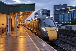
Transport in the United Kingdom is highly facilitated by road, rail, air and water networks. Transport is a devolved matter with each of the countries of the United Kingdom having separate systems under separate governments.

<span class="mw-page-title-main">Transport in Australia</span> Overview of the transport in Australia

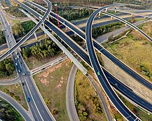
There are many forms of transport in Australia. Australia is highly dependent on road transport. There are more than 300 airports with paved runways. Passenger rail transport includes widespread commuter networks in the major capital cities with more limited intercity and interstate networks. The Australian mining sector is reliant upon rail to transport its product to Australia's ports for export.

<span class="mw-page-title-main">CityRail</span> Sydney passenger rail network operator

CityRail was a passenger railway brand operated by the State Rail Authority from 1989 to 2003 and by RailCorp from 2003 to 2013 with services in and around Sydney, Newcastle and Wollongong, the three largest cities in New South Wales, Australia. It was established in January 1989 and abolished in June 2013 when it was superseded by Sydney Trains and NSW TrainLink.

<span class="mw-page-title-main">Airport & South Line</span> Rail service in Sydney, New South Wales

The Airport & South Line is a suburban commuter rail line in Sydney, Australia. It connects the Sydney central business district with the southwestern suburbs via Sydney Airport. The line is part of the Sydney Trains network. The line began operating on 26 November 2017, when the T2 Airport, Inner West & South Line was split in two. Sydney Trains' predecessor CityRail operated the Airport & East Hills Line over an identical route between 2000 and 2013.

<span class="mw-page-title-main">Main North railway line, New South Wales</span> Railway line in New South Wales, Australia

The Main North Line is a major railway in New South Wales, Australia. It runs through Strathfield to Wallangarra. The line was the original main line between Sydney and Brisbane, however this required a change of gauge at Wallangarra. As of 1988, the line closed progressively north of Armidale with services gradually withdrawn till 2004, with the main route between Sydney and Brisbane now the North Coast line.

<span class="mw-page-title-main">Rhodes railway station</span> Railway station in Sydney, New South Wales, Australia

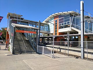
Rhodes railway station is a heritage-listed railway station located on the Main Northern line, serving the Sydney suburbs of Rhodes and Liberty Grove both in City of Canada Bay, Sydney, New South Wales, Australia. It is served by Sydney Trains T9 Northern Line services.

<span class="mw-page-title-main">State Transit Authority</span> NSW Government public transit authority

The State Transit Authority of New South Wales, also referred to as State Transit, was an agency of the Government of New South Wales operating bus services in Sydney. Superseding the Urban Transit Authority in 1989, it was also responsible for the provision of ferry services in Sydney until 2004 and bus and ferry services in Newcastle until 2017. It ceased trading after 2 April 2022 with its remaining operations to be contracted out by Transport for NSW to replacement operators.

<span class="mw-page-title-main">Transport in Melbourne</span> Overview of transport in Melbourne, Victoria, Australia

Transport in Melbourne, the state capital of Victoria, Australia, consists of several interlinking modes. Melbourne is a hub for intercity, intracity and regional travel. Road-based transport accounts for most trips across many parts of the city, facilitated by Australia's largest freeway network. Public transport, including the world's largest tram network, trains and buses, also forms a key part of the transport system. Other dominant modes include walking, cycling and commercial-passenger vehicle services such as taxis.

<span class="mw-page-title-main">Transport in Wales</span> Overview of the transportation system in Wales

Transport in Wales is heavily influenced by the country's geography. Wales is predominantly hilly or mountainous, and the main settlements lie on the coasts of north and south Wales, while mid Wales and west Wales are lightly populated. The main transport corridors are east–west routes, many continuing eastwards into England.

<span class="mw-page-title-main">Buses in Sydney</span> Bus networks in Sydney, Australia

Buses account for close to six per cent of trips each day in the city of Sydney, New South Wales, Australia, forming a key part of the city's public transport system. The network initially evolved from a privately operated system of feeder services to railway stations in the outer suburbs, and a publicly operated network of bus services introduced to replace trams in the inner suburbs. The bus network has undergone major reforms since the 2000s–2010s, with the New South Wales Government taking responsibility for route and fare-setting, opening contracts for most routes up to competitive tendering, and introducing more cross-suburban services.

<span class="mw-page-title-main">Railways in Sydney</span>

Sydney, the largest city in Australia, has an extensive network of passenger and freight railways. The passenger system includes an extensive suburban railway network, operated by Sydney Trains, a metro network and a light rail network. A dedicated freight network also exists. Future expansion of the light rail network includes the Parramatta Light Rail. Existing light rail services are the Inner West Light Rail and the CBD & South East Light Rail.

<span class="mw-page-title-main">Transport in Brisbane</span>

Transport in Brisbane, the capital and largest city of Queensland, Australia, is provided by road, rail, river and bay ferries, footpaths, bike paths, sea and air.

<span class="mw-page-title-main">Sydney Metro Northwest</span> Rapid transit rail project in Sydney, New South Wales, Australia

Sydney Metro Northwest was a rapid transit project that constructed the first section of the Metro North West Line through the north-western suburbs of Sydney, New South Wales, Australia. The project included the conversion of the existing Epping to Chatswood rail link to metro standards and connects the suburbs of Rouse Hill and Chatswood via Castle Hill and Epping. The project was managed by Transport for NSW. The completed Metro North West Line opened on the 26 May 2019.

<span class="mw-page-title-main">Metrobus (Sydney)</span> Sydney high frequency, high capacity bus network

Metrobus is a high frequency, high capacity bus network in Sydney, Australia, first introduced in 2008. Metrobus services run every 10 minutes during peak periods, 15 minutes during off-peak weekday periods, and 20 minutes on weekends, linking key commercial suburbs and centres throughout the city, with the intention of making timetables obsolete. All buses were initially painted in a distinctive red livery but recently, the standard Transport for NSW livery of blue and white has been adopted. All Metrobus services are wheelchair accessible. All route numbers were prefixed with an "M" followed by a two-digit number.

<span class="mw-page-title-main">Kellyville railway station</span> Sydney Metro railway station

Kellyville railway station is an elevated station on the Metro North West Line, as part of the Sydney Metro network. The station was built by Impregilo-Salini and Metro Trains Sydney for Transport for NSW, and is situated along Samantha Riley Drive, Kellyville, in Sydney, Australia. Train services from the station run to Rouse Hill and Chatswood, with a journey time to Chatswood of around 33 minutes. As the New South Wales Government's Sydney's Rail Future strategy is delivered over the next 20 years, services are expected to be extended to the Sydney central business district (CBD) and Bankstown. Kellyville Station opened on 26 May 2019.

<span class="mw-page-title-main">Transport for NSW</span> Statutory authority of the New South Wales Government

Transport for NSW (TfNSW) is a New South Wales government transport and road agency established on 1 November 2011. The agency is a different entity to the New South Wales Department of Transport, a department of the New South Wales Government and the ultimate parent entity of Transport for NSW.

<span class="mw-page-title-main">Sydney Trains</span> Operator of passenger rail services in metropolitan Sydney

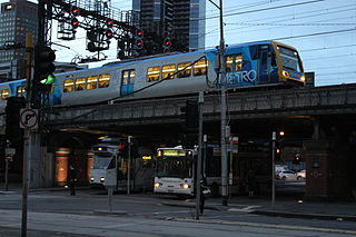
Sydney Trains is the operator and brand name of the commuter rail network serving the city of Sydney, New South Wales, Australia. The network is a commuter rail system with a central underground core that covers 369 km (229 mi) of route length over 813 km (505 mi) of track, with 170 stations on eight lines.

Transdev Australasia is an operator of bus, ferry, light rail and rail services in Australia and New Zealand. It is a subsidiary of French-based, international Transdev. It was formed in 2013 by grouping the operations of Veolia Transport Australia and former Transdev together, as a result of the global rebranding from Veolia Transdev to Transdev.

<span class="mw-page-title-main">Bella Vista railway station</span> Sydney Metro railway station

Bella Vista railway station is a Sydney Metro station on the western edge of the Norwest Business Park in Sydney, Australia. The station serves the Metro North West Line and was built as part of the Sydney Metro Northwest project. The station is planned to eventually serve trains to the Sydney central business district and Bankstown as part of the government's 20-year Sydney's Rail Future strategy.

The 2010s saw many developments relating to transport in the Australian city of Sydney, New South Wales. The decade saw a substantial investment in infrastructure, including a new airport, motorway projects, light rail lines, Australia's first metro system, the new Waratah fleet and the demise of the non-air conditioned S sets from the rail network. Planning and branding of public transport services became substantially more centralised.

References

  1. "4102.0 - Australian Social Trends, 2008". Australian Bureau of Statistics. 23 July 2008. Retrieved 6 April 2013.
  2. 1 2 Forster, Clive 1996 Australian Cities: Continuity and Change. Oxford University Press
  3. "Sydney's transport network lags Brisbane in global rankings". Sydney Morning Herald . 30 October 2017. Retrieved 2 November 2017.
  4. "Australian cities lag behind on key global competitiveness measure". News.com.au . 30 October 2017. Retrieved 2 November 2017.
  5. Public Transport Users Association. "Fare Comparison". PTUA Survey. Retrieved 29 January 2012.
  6. 2000 "Bus Users in Sydney" Report from the Transport Data Centre, part of Transport NSW Archived 27 March 2011 at the Wayback Machine – provides state & private bus trips taken, total derived from that. "About Transport in New South Wales" page from Transport NSW Archived 27 March 2011 at the Wayback Machine – provides total trips taken (about 2 million), "about half" derived from that and total bus trips taken. "Archived copy". Archived from the original on 27 March 2011. Retrieved 18 February 2013.{{cite web}}: CS1 maint: archived copy as title (link)
  7. "Sydney Metro: Info". sydneymetro.info. 13 July 2015.
  8. "Sydney Metro an Australian first". mondaq.com. 8 December 2009. Retrieved 13 July 2015.
  9. 1 2 Ian Imrie (29 July 2008). "Sharing tracks in Sydney". Railway Gazette International . Retrieved 16 August 2008.
  10. "Southern Sydney Freight Line Project". ssfl.artc.com.au. Archived from the original on 11 April 2013. Retrieved 16 August 2008.
  11. "Port Botany Rail Freight Strategy –". NSW Parliament: Questions Without Notice. parliament.nsw.gov.au. 31 May 2007. Retrieved 16 August 2008.
  12. "Home". SIMTA. Retrieved 29 June 2021.
  13. "Enfield Intermodal Logistics Centre | NSW Ports". www.nswports.com.au. Retrieved 29 June 2021.
  14. "Sydney Ports – Rail Operations". sydneyports.com.au. Retrieved 16 August 2008.
  15. "Rail network needs to avoid peak crunch by 2019". govnews.com.au. April 2017.
  16. "Sydney Ferries". Transport for NSW. 7 December 2012. Retrieved 18 February 2013. In 2011-12, 173,329 ferry services were scheduled, carrying 14.7 million passengers.
  17. Giles-Corti, Billie; Arundel, Jonathan (10 April 2018). "Too many cars, too few supermarkets: how Australia's cities really stack up". The Guardian . ISSN   0261-3077 . Retrieved 25 October 2019.
  18. "Number of cars per household | City of Sydney | Community profile". profile.id.com.au. Retrieved 25 October 2019.
  19. O'Sullivan, Matt (23 October 2017). "Sydneysiders the nation's biggest users of public transport for work commute". The Sydney Morning Herald. Retrieved 25 October 2019.
  20. Smith, Alexandra (10 January 2008). "Money wasted on cyclists: NRMA". Sydney Morning Herald . Retrieved 10 December 2016.
  21. Cycling in New South Wales#Regulations
  22. "Bicycle Strategy and Action Plan". City of Sydney. Retrieved 29 October 2013.
  23. Paul Bibby (4 May 2009). "Dedicated cycleway opens in the city after months of frustration". Sydney Morning Herald . Fairfax Media. Archived from the original on 7 November 2012. Retrieved 18 September 2013.
  24. "Ministerial Inquiry into the Taxi Industry", NSW Ministry of Transport (5 October 2004)
  25. "Top 10 busiest airports in Australia". AirMundo. Retrieved 25 October 2019.
  26. "Sydney Public Transportation Statistics". Global Public Transit Index by Moovit. Retrieved 19 June 2017. CC-BY icon.svg Material was copied from this source, which is available under a Creative Commons Attribution 4.0 International License.