
Lycoming County is a county in the Commonwealth of Pennsylvania. As of the 2020 census, the population was 114,188. Its county seat is Williamsport.

Loyalsock Township is a township in Lycoming County, Pennsylvania, United States. The population was 11,561 at the 2020 census. It is part of the Williamsport Metropolitan Statistical Area. It is the second largest municipality in Lycoming County, in terms of population, behind the county seat, Williamsport.

Plunketts Creek Township is a township in Lycoming County, Pennsylvania, United States. It includes the villages of Barbours and Proctor. The population was 595 at the 2020 census, down from 684 at the 2010 census. It is part of the Williamsport Metropolitan Statistical Area.

Williamsport is a city in, and the county seat of, Lycoming County, Pennsylvania, United States. As of 2020, it had a population of 27,754. It is the principal city of the Williamsport Metropolitan Statistical Area, which has a population of about 114,000. Williamsport is the larger principal city of the Williamsport-Lock Haven Combined Statistical Area, which includes Lycoming and Clinton counties.

The West Branch Susquehanna River is one of the two principal branches, along with the North Branch, of the Susquehanna River in the Northeastern United States. The North Branch, which rises in upstate New York, is generally regarded as the extension of the main branch, with the shorter West Branch being its principal tributary.

Lycoming Creek is a 37.5-mile-long (60.4 km) tributary of the West Branch Susquehanna River located in Tioga and Lycoming counties in Pennsylvania in the United States.

Loyalsock Creek is a 64-mile-long (103 km) tributary of the West Branch Susquehanna River located chiefly in Sullivan and Lycoming counties in Pennsylvania in the United States. As the crow flies, Lycoming County is about 130 miles (209 km) northwest of Philadelphia and 165 miles (266 km) east-northeast of Pittsburgh.

The Lycoming Valley Railroad is a short line that operates 38 miles (61 km) of track in Lycoming and Clinton counties in Pennsylvania in the United States. It is part of the North Shore Railroad System.

Susquehanna State Park is a Pennsylvania state park on 20 acres (8.1 ha) in Williamsport in Lycoming County, Pennsylvania in the United States. The park is on the West Branch Susquehanna River in the western part of Williamsport, and is operated by the Williamsport / Lycoming Chamber of Commerce in cooperation with the Bureau of State Parks of the Pennsylvania Department of Conservation and Natural Resources. Susquehanna State Park offers cruises on a paddlewheeler, boating, fishing, and picnicking.

River Valley Transit provides public bus transportation throughout Lycoming County, Pennsylvania.

The West Branch Susquehanna Valley of central Pennsylvania, United States, in the Ridge-and-valley Appalachians, is the low-lying area draining into the West Branch Susquehanna River southeast of the Allegheny Front, northeast of the Bald Eagle Valley, southwest of the Wyoming Valley and north of the water gap formed between Shamokin Mountain and Montour Ridge.

This article details a history of Lycoming County, Pennsylvania.
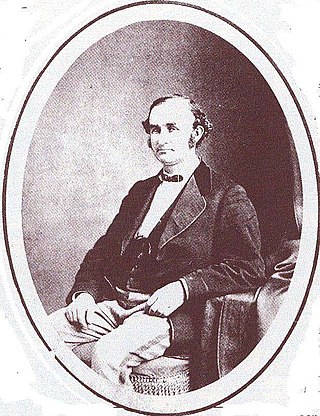
Peter Herdic (1824–1888) was a lumber baron, entrepreneur, inventor, politician, and philanthropist in Victorian era Williamsport, Lycoming County, Pennsylvania in the United States. He was the youngest of seven children born to Henry and Elizabeth Herdic on December 14, 1824 in Fort Plain, New York. Herdic's father died in 1826 and Elizabeth Herdic remarried shortly thereafter. She was widowed again prior to 1837 when she moved her family to Pipe Creek, New York near Ithaca. Herdic attended school for just a few years while he worked on his mother's 50-acre (200,000 m2) farm. Herdic left his mother's farm in 1846 and arrived in Lycoming County later that same year, where he settled in Cogan House Township.
Williamsport was incorporated as a borough on March 1, 1806, and as a city on January 15, 1866. The city is the original home of Little League Baseball, founded in 1939 as a three-team league.

Daniel Hughes (1804–1880) was a conductor, agent and station master in the Underground Railroad based in Loyalsock Township, Lycoming County, Pennsylvania in the United States. He was the owner of a barge on the Pennsylvania Canal and transported lumber from Williamsport on the West Branch Susquehanna River to Havre de Grace, Maryland. Hughes hid runaway slaves in the hold of his barge on his return trip up the Susquehanna River to Lycoming County, where he provided shelter to the runaways on his property near the Loyalsock Township border with Williamsport before they moved further north and to eventual freedom in Canada. Hughes' home was located in a hollow or small valley in the mountains just north of Williamsport. This hollow is now known as Freedom Road, having previously been called Nigger Hollow. In response to the actions of concerned African American citizens of Williamsport, the pejorative name was formally changed by the Williamsport City Council in 1936.

Plunketts Creek is an approximately 6.2-mile-long (10 km) tributary of Loyalsock Creek in Lycoming and Sullivan counties in the U.S. state of Pennsylvania. Two unincorporated villages and a hamlet are on the creek, and its watershed drains 23.6 square miles (61 km2) in parts of five townships. The creek is a part of the Chesapeake Bay drainage basin via Loyalsock Creek and the West Branch Susquehanna and Susquehanna Rivers.
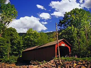
The Sonestown Covered Bridge is a covered bridge over Muncy Creek in Davidson Township, Sullivan County, Pennsylvania built around 1850. It is 110 ft (34 m) long and was placed on the National Register of Historic Places (NRHP) in 1980. It is named for the nearby unincorporated village of Sonestown in Davidson Township, and is also known as the Davidson Covered Bridge. It was built to provide access to a grist mill which operated until the early 20th century.

The Forksville Covered Bridge is a Burr arch truss covered bridge over Loyalsock Creek in the borough of Forksville, Sullivan County, in the U.S. state of Pennsylvania. It was built in 1850 and is 152 feet 11 inches (46.61 m) in length. The bridge was placed on the National Register of Historic Places in 1980. The Forksville bridge is named for the borough it is in, which in turn is named for its location at the confluence or "forks" of the Little Loyalsock and Loyalsock Creeks.
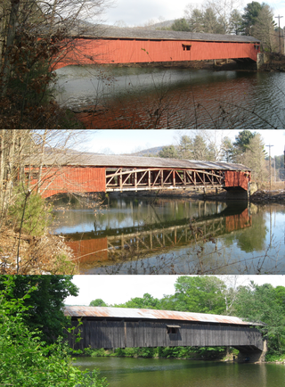
The Hillsgrove Covered Bridge is a Burr arch truss covered bridge over Loyalsock Creek in Hillsgrove Township, Sullivan County, in the U.S. state of Pennsylvania. It was built c. 1850 and is 186 feet (56.7 m) long. In 1973, it became the first covered bridge in the county to be placed on the National Register of Historic Places (NRHP). The bridge is named for the township and nearby unincorporated village of Hillsgrove, and is also known as Rinkers Covered Bridge for an adjoining farm.
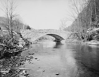
Plunketts Creek Bridge No. 3 was a rubble masonry stone arch bridge over Plunketts Creek in Plunketts Creek Township, Lycoming County in the U.S. state of Pennsylvania. It was built between 1840 and 1875, probably closer to 1840, when the road along the creek between the unincorporated villages of Barbours and Proctor was constructed. Going upstream from the mouth, the bridge was the third to cross the creek, hence its name.


