Tripoli Province (Provincia di Tripoli in Italian) was one of the provinces of Libya under Italian rule. It was established in 1937, with the official name: Commissariato Generale Provinciale di Tripoli. It lasted until 1947.
Tripoli Province (Provincia di Tripoli in Italian) was one of the provinces of Libya under Italian rule. It was established in 1937, with the official name: Commissariato Generale Provinciale di Tripoli. It lasted until 1947.
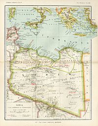
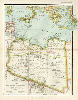
The "Provincia di Tripoli" was located in northern Italian Libya, next to Tunisia. Its administrative center was the city of Tripoli on the Mediterranean coast and was administratively divided in 6 sections (called "Circondari" in Italian):
The province experienced a huge economic growth in the late 1930s, with a great urban development of Tripoli while Italian colonists cultivated lands (that had returned to native desert for many centuries) and improved Italian Libya's agriculture to international standards. This was accomplished even with the creation of new farm villages. [1]
Most of the population was Muslim, but there was a growing community of Catholics due to the Italian colonists immigration. [2] In 1940 there were more than 70,000 Catholics (of which 65,000 were Italians).
Additionally there were nearly 18,000 Jews in the Tripoli area. [3] Indeed, after the Italian occupation of Libya in 1911, the Jews made great strides in education and economic conditions: at that time, there were about 21,000 Jews in the country, the majority in Tripoli. In the late 1930s, Fascist anti-Jewish laws were gradually enforced, and Jews were subject to moderate repression: still, by 1941 -due even to the partial rejection of those laws by governor Italo Balbo- the Jews accounted for a quarter of the population of Tripoli and maintained 44 synagogues [4]
The province from 1939 was considered officially part of the Kingdom of Italy, with the same laws. It was one of the 4 new Italian provinces of the so-called Quarta Sponda ("Fourth Shore") of Mussolini's Imperial Italy. Indeed, on January 9, 1939, the colony of Italian Libya was incorporated into "Metropolitan Italy" and thereafter considered an integral part of the Italian state (the French, in 1848, had incorporated French Algeria in the same manner).
In the coast of the province was built in 1937-1938 a section of the Litoranea Balbia, a road that went from Tripoli and Tunisia's frontier to the border of Egypt.

The car tag for the Italian province of Tripoli was "TL". [5] In the province was even created the Tripoli Grand Prix, an international motor racing event first held in 1925 on a racing circuit outside Tripoli (it lasted until 1940). [6]
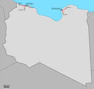
Tripoli had a railway station with some small railway connections to nearby cities, when in August 1941 the Italians started to build a new 1040 km railway (with a 1435 mm. gauge, like the one used in Egypt and Tunisia) between Tripoli and Benghazi.
But the war (with the defeat of the Italian Army) stopped the construction the next year. The project was stopped in the fall of 1942, leaving many infrastructures like stations and connection roads already done in the "Provincia di Tripoli".
The indigenous population was Arab, with some berbers in the Nafusa Mountains south of Tripoli and some thousands Jews and a few Maltese [7] on the coast. The Italians colonized the coastal cities and were mainly in the capital Tripoli, where they were nearly half the inhabitants in 1940.
According to the 1936 census, which allowed citizens to declare their ethnicity, Tripoli's native population was made up of 79.1% Arabs, 9.8% Berbers, 3.4% Blacks, 1.7% Turks and 6% Others. [8]
In the province of Tripoli thousands of Italians (called "ventimilli") moved to live in 1938 and 1939 and founded some agricultural villages (like "Bianchi", [9] "Giordani", "Oliveti", [10] "Marconi", etc..). [11]
According to the 1939 Italian Census of Libya, [12] these were the main population data:

| CITY | INHABITANTS | ITALIANS | NOTES |
|---|---|---|---|
| Tripoli | 111,124 pop. | 41,304 | Nearly 50,000 Italians lived in the city and surroundings: 37% of the city's inhabitants. |
| Castel Benito | 10,759 pop. | 567 | Italians were nearly 5%. |
| Zanzur | 14.408 pop. | 289 | Italians were nearly 2%. |
| Bianchi | 2,854 pop. | 2,854 | Italian agricultural village founded in 1937 by ETL & INFPS [13] |
| Giordani | 2,300 pop. | 2,300 | Italian agricultural village founded in 1938 by ETL & INFPS. |
| Oliveti | 1,300 pop. | 1,300 | Italian agricultural village founded in 1938 by INFPS & ETL. |
| Zuavia | 30,033 pop. | 2,040 | Italians were nearly 6%. |
| Sorman | 13,137 pop. | 262 | Italians more than 2%. |
| Sabratha | 23,407 | 397 | Italians were 1,7%. |
| Zuwara | 27,956 pop. | 662 | Italians were nearly 2%. |
| Castelverde | 6,458 pop. | 270 | Italians were nearly 4%: today is called GASR GARABULLI. |
| Mizda | 1,113 pop. | - | Village mostly berber. |
| Giado | 14,466 pop. | 48 | Italians were 0,3%. |
| Nalut | 20,471 pop. | 126 | Italians were 0,6%. |
fascismo (1934-1940). PhD, Vienna University of Technology, 2007.

Oea was an ancient city in present-day Tripoli, Libya. It was founded by the Phoenicians in the 7th century BC and later became a Roman–Berber colony. As part of the Roman Africa Nova province, Oea and surrounding Tripolitania were prosperous. It reached its height in the 2nd and 3rd centuries AD, when the city experienced a golden age under the Severan dynasty in nearby Leptis Magna. The city was conquered by the Rashidun Caliphate with the spread of Islam in the 7th century and came to be known as Tripoli during the 9th century.

Misrata or Misratah, also known by the Italian spelling Misurata, is a city in the Misrata District in northwestern Libya, situated 187 km (116 mi) to the east of Tripoli and 825 km (513 mi) west of Benghazi on the Mediterranean coast near Cape Misrata. With a population of about 881,000, it is the third-largest city in Libya, after Tripoli and Benghazi. It is the capital city of the Misrata District and has been called the trade capital of Libya. The harbor is at Qasr Ahmad.

Tripolitania, historically known as the Tripoli region, is a historic region and former province of Libya.

The Italian colonizationof Libya began in 1911 and it lasted until 1943. The country, which was previously an Ottoman possession, was occupied by Italy in 1911 after the Italo-Turkish War, which resulted in the establishment of two colonies: Italian Tripolitania and Italian Cyrenaica. In 1934, the two colonies were merged into one colony which was named the colony of Italian Libya. In 1937, this colony was divided into four provinces, and in 1939, the coastal provinces became a part of metropolitan Italy. The colonization lasted until Libya's occupation by Allied forces in 1943, but it was not until the 1947 Paris Peace Treaty that Italy officially renounced all of its claims to Libya's territory.

The military history of Libya covers the period from the ancient era to the modern age.

Libya was a colony of Fascist Italy located in North Africa, in what is now modern Libya, between 1934 and 1943. It was formed from the unification of the colonies of Cyrenaica and Tripolitania, which had been Italian possessions since 1911.
Italian Tripolitania was an Italian colony, located in present-day western Libya, that existed from 1911 to 1934. It was part of the territory conquered from the Ottoman Empire after the Italo-Turkish War in 1911. Italian Tripolitania included the western northern half of Libya, with Tripoli as its main city. In 1934, it was unified with Italian Cyrenaica in the colony of Italian Libya. In 1939, Tripolitania was considered a part of the Kingdom of Italy's 4th Shore.
Italian Cyrenaica was an Italian colony, located in present-day eastern Libya, that existed from 1911 to 1934. It was part of the territory conquered from the Ottoman Empire during the Italo-Turkish War of 1911, alongside Italian Tripolitania.

Italian Libyans are Libyan-born citizens who are fully or partially of Italian descent, whose ancestors were Italians who emigrated to Libya during the Italian diaspora, or Italian-born people in Libya. Most of the Italians moved to Libya during the Italian colonial period.

Few railway stations were built in Libya during the 20th century. The ones that were built were by the Italians from the 1920s as part of their colonial administration. Today there are no functioning railway stations active in the country, but new ones are planned, as part of a new railroad system.

The Libyan Coastal Highway, formerly the Litoranea Balbo, is a highway that is the only major road that runs along the entire east-west length of the Libyan Mediterranean coastline. It is a section in the Cairo–Dakar Highway #1 in the Trans-African Highway system of the African Union, Arab Maghreb Union and others.

Al-Khums or Khoms is a city, port and the de jure capital of the Murqub District on the Mediterranean coast of Libya with an estimated population of around 202,000. The population at the 1984 census was 38,174. Between 1983 and 1995 it was the administrative center of al-Khums District.
Benghazi Province, or Provincia di Bengasi in Italian, was one of the provinces of Libya under Italian rule. It was established in 1937.

Misrata Governorate was one of the governorates (muhafazah) of Libya from 1963 to 1983. Its capital was the town of Misrata. Initially in the 1930s was called "Provincia di Misurata" of Italian Libya. It was created out of the eastern part of Tripolitania province.
The area of North Africa which has been known as Libya since 1911 was under Roman domination between 146 BC and 672 AD. The Latin name Libya at the time referred to the continent of Africa in general. What is now coastal Libya was known as Tripolitania and Pentapolis, divided between the Africa province in the west, and Crete and Cyrenaica in the east. In 296 AD, the Emperor Diocletian separated the administration of Crete from Cyrenaica and in the latter formed the new provinces of "Upper Libya" and "Lower Libya", using the term Libya as a political state for the first time in history.
Darnah Province was one of the provinces of Libya under Italian rule. It was established in 1937 with the official name: "Commissariato Generale Provinciale di Derna". Derna province was called only "Darnah District" after World War II.
Italian Libya Railways was a group of railways built in the Italian colony of Libya between the two World Wars.
Italian Benghazi was the name used during the Italian colonization of Libya for the port-city of Benghazi in Italian Cyrenaica.

The Fourth Shore or Italian North Africa was the name created by Benito Mussolini to refer to the Mediterranean shore of coastal colonial Italian Libya and, during World War II, Italian Tunisia in the fascist-era Kingdom of Italy, during the late Italian colonial period of Libya and the Maghreb.

Tripolitania province is one of the three traditional Provinces of Libya. It was a formal province from 1934 until 1963, when it was subdivided into the Governorates of Libya. Its capital was the city of Tripoli. Between 1911 and 1934 it had been the separately governed colony of Italian Tripolitania.