
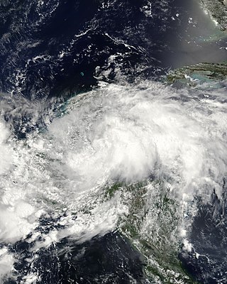
The 2002 Atlantic hurricane season was a near-average Atlantic hurricane season. It officially started on June 1, 2002, and ended on November 30, dates which conventionally limit the period of each year when most tropical cyclones develop in the Atlantic Ocean. The season produced fourteen tropical cyclones, of which twelve developed into named storms; four became hurricanes, and two attained major hurricane status. While the season's first cyclone did not develop until July 14, activity quickly picked up: eight storms developed in the month of September. It ended early however, with no tropical storms forming after October 6—a rare occurrence caused partly by El Niño conditions. The most intense hurricane of the season was Hurricane Isidore with a minimum central pressure of 934 mbar, although Hurricane Lili attained higher winds and peaked at Category 4 whereas Isidore only reached Category 3. However, Lili had a minimum central pressure of 938 mbar.

The 2006 Atlantic hurricane season was the least active since 1997 as well as the first season since 2001 in which no hurricanes made landfall in the United States, and was the first since 1994 in which no tropical cyclones formed during October. Following the intense activity of 2003, 2004, and 2005, forecasters predicted that the 2006 season would be only slightly less active. Instead, it turned out to be a below average season, as activity was slowed by a rapidly forming moderate El Niño event, the presence of the Saharan Air Layer over the tropical Atlantic, and the steady presence of a robust secondary high-pressure area to the Azores High centered on Bermuda. There were no tropical cyclones after October 2.

Tropical Storm Alberto was the first tropical storm of the 2006 Atlantic hurricane season. Forming on June 10 in the northwestern Caribbean, the storm moved generally to the north, reaching a maximum intensity of 70 mph (110 km/h) before weakening and moving ashore in the Big Bend area of Florida on June 13. Alberto then moved through eastern Georgia, North Carolina, and Virginia as a tropical depression before becoming extratropical on June 14.

Tropical Storm Beryl was the third tropical storm of the 2006 Atlantic hurricane season. Developing from a tropical disturbance on July 18, it tracked generally northward, and strengthened to attain peak winds of 60 mph (97 km/h) under generally favorable conditions. After turning to the northeast, Beryl weakened over cooler waters. On July 21 it struck the island of Nantucket, and shortly thereafter it became extratropical. The extratropical remnants continued northeastward through Nova Scotia, and on July 22 it merged with an approaching cold front.
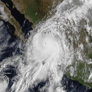
Hurricane Lane was the strongest Pacific hurricane to make landfall in Mexico since Hurricane Kenna of 2002. The thirteenth named storm, ninth hurricane, and sixth major hurricane of the 2006 Pacific hurricane season, Lane developed on September 13 from a tropical wave to the south of Mexico. It moved northwestward, parallel to the coast of Mexico, and steadily intensified in an area conducive to further strengthening. After turning to the northeast, Lane attained peak winds of 125 mph (201 km/h), and made landfall in the state of Sinaloa at peak strength. It rapidly weakened and dissipated on September 17, and later brought precipitation to southern part of the U.S. state of Texas.

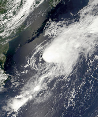
Tropical Storm Chantal was a short-lived tropical storm that affected Bermuda in its formative stages and caused flooding and gusty winds in Newfoundland while extratropical. The third named storm of the 2007 Atlantic hurricane season, Chantal developed on July 31 from non-tropical origins between Bermuda and Cape Cod, and with favorable conditions, the storm rapidly attained peak winds of 50 mph (80 km/h). The storm accelerated northeastward over an area of progressively colder water temperatures, and after a decrease in convection the National Hurricane Center ceased issuing advisories as Chantal began undergoing extratropical transition early on August 1. Shortly thereafter, the extratropical remnant crossed over southeastern Newfoundland before tracking into the open waters of the north Atlantic Ocean. Prior to forming, the storm dropped moderate rainfall on Bermuda. Subsequent to becoming extratropical, the remnants of Chantal produced gusty winds and heavy precipitation across the Avalon Peninsula of Newfoundland, causing flooding and wind damage; insured damage totaled $25 million.

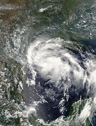
Tropical Storm Gabrielle was a short-lived tropical cyclone that passed over North Carolina before tracking out to sea. The seventh named storm of the 2007 Atlantic hurricane season, Gabrielle developed as a subtropical cyclone on September 8 about 385 miles (620 km) southeast of Cape Lookout, North Carolina. Unfavorable wind shear impacted the storm for much of its duration, although a temporary decrease in the shear allowed the cyclone to become a tropical storm. On September 9, Gabrielle made landfall at Cape Lookout National Seashore in the Outer Banks of North Carolina with winds of 60 mph (97 km/h). Turning to the northeast, the storm quickly weakened and dissipated on September 11.

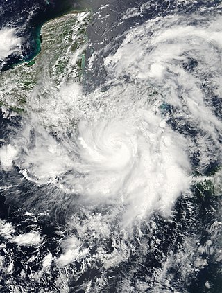
Hurricane Noel was a deadly tropical cyclone that carved a path of destruction across the Atlantic Ocean from the Caribbean Sea to Newfoundland in late October 2007. The sixteenth tropical depression, fourteenth named storm, and the sixth hurricane of the 2007 Atlantic hurricane season, Noel formed on October 27 from the interaction between a tropical wave and an upper-level low in the north-central Caribbean. It strengthened to winds of 60 mph (97 km/h) before making landfall on western Haiti and the north coast of eastern Cuba. Noel turned northward, and on November 1, it attained hurricane status. The hurricane accelerated northeastward after crossing the Bahamas, and on November 2, it transitioned into an extratropical cyclone.
Tropical Storm Erin was a minimal tropical storm that made landfall in Texas in August 2007. The storm's remnants also unexpectedly restrengthened over Oklahoma, causing damage there as well. The second tropical cyclone to make landfall in the United States in the 2007 Atlantic hurricane season and the fifth named storm of the year, Erin formed in the Gulf of Mexico on August 14 from a persistent area of convection. It attained tropical storm status the next day, and on August 16, 2007, Erin made landfall near Lamar, Texas, and persisted over land across Texas before moving northward into Oklahoma. Due to the brown ocean effect, Erin intensified after landfall. The storm resulted in sixteen fatalities and worsened an already-severe flooding issue in Texas.
Tropical Storm Arthur was the first tropical cyclone of the relatively quiet 2002 Atlantic hurricane season. The origins of the storm are believed to have been from a decaying cold front in the Gulf of Mexico, which dropped light to moderate rainfall across the southeastern United States. Developing on July 14 near the coast of North Carolina, Arthur tracked quickly east-northward through much of its duration as a tropical cyclone. It reached peak winds of 60 mph (97 km/h) on July 16, though as it interacted with a mid-level cyclone and cooler waters it transitioned into an extratropical cyclone. The remnants of Arthur passed over Newfoundland with gusty winds and rainfall, where one person drowned. Arthur was the first tropical storm to form in the month of July since Alex of 1998.
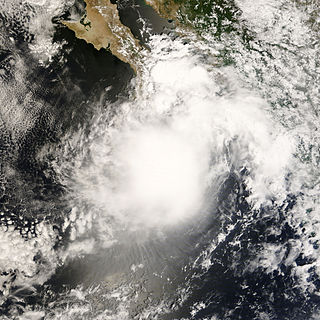
Tropical Storm Alma of the 2008 Pacific hurricane season was the easternmost forming Pacific tropical cyclone on record. It formed within the monsoon trough just off the coast of Costa Rica on May 29. Initially forecast to remain a weak tropical storm, the cyclone rapidly strengthened and developed an eye, before making landfall on May 29 in Nicaragua, near León, with peak winds of 65 mph (105 km/h). Alma degenerated into a remnant low on May 30, before merging with another approaching tropical wave in the Gulf of Honduras shortly afterward, which became Tropical Storm Arthur on the next day. Alma was the first tropical storm on record to strike the Pacific coast of Nicaragua. In Costa Rica, heavy rainfall caused flooding and landslides, killing two and causing $35 million (USD) in damage. Three people were killed in Nicaragua, one from drowning and two others from electrocution. Five others died in Honduras from an aviation accident likely related to the storm and one other was swept away in floodwaters.
Tropical Storm Arthur was the first Atlantic tropical storm that formed during the month of May since 1981. The first tropical cyclone of the 2008 Atlantic hurricane season, the storm formed on May 30, 2008 from the interaction of two tropical waves and the remnants of the eastern Pacific Tropical Storm Alma, which had crossed into the western Caribbean Sea. The system quickly organized and was named Tropical Storm Arthur on May 31, while crossing the shore of Belize. It dissipated two days later over the Yucatán Peninsula in Mexico. Arthur and its remnants triggered severe flooding which killed a reported nine people and affected 100,000 more in Belize. Damage was light to moderate, estimated at $78 million (2008 USD).

Hurricane Bertha was the longest-lived Atlantic tropical cyclone on record during July, as well as the furthest east system to attain tropical storm intensity during the month. The second named storm, first hurricane, and first major hurricane of the active 2008 season, Bertha developed into a tropical depression on July 3 from a tropical wave that departed western Africa two days prior. On a west-northwest to northwest track, the depression intensified into Tropical Storm Bertha six hours formation and ultimately attained hurricane intensity on July 7. A period of rapid deepening brought the cyclone to its peak as a Category 3 hurricane with winds of 125 mph (205 km/h) late that afternoon. Changes in wind shear and the storm's internal structure allowed Bertha to fluctuate in intensity over the next week as it passed very near Bermuda, but a track over cooler waters eventually caused the system to become an extratropical cyclone by July 20. It continued northeast and was absorbed by another low near Iceland the following day. Rough surf propelled by Bertha killed three people along the East Coast of the United States; hundreds of other swimmers were injured and/or required rescuing. In Bermuda, some streets were flooded and strong gusts cut power to approximately 7,500 homes; only minor damage was observed.

Tropical Storm Norman was a weak tropical cyclone that brought heavy rainfall to southwestern Mexico in October 2006. The fifteenth named storm of the 2006 Pacific hurricane season, Norman developed on October 9 from a tropical wave well to the southwest of Mexico. Unfavorable conditions quickly encountered the system, and within two days of forming, Norman dissipated as its remnants turned to the east. Thunderstorms gradually increased again, as it interacted with a disturbance to its east, and on October 15 the cyclone regenerated just off the coast of Mexico. The center became disorganized and quickly dissipated, bringing a large area of moisture which dropped up to 6 inches (150 mm) of rainfall to southwestern Mexico. Rainfall from the storm flooded about 150 houses, of which 20 were destroyed. One person was injured, and initially there were reports of two people missing due to the storm; however, it was not later confirmed.
Tropical Storm Julio was a tropical storm that made landfall on the southern tip of Baja California Sur in August 2008. The tenth named storm of the 2008 Pacific hurricane season, it developed from a tropical wave on August 23 off the coast of Mexico. It moved parallel to the coast, reaching peak winds of 50 mph (85 km/h) before moving ashore and weakening. On August 26 it dissipated in the Gulf of California. Julio was the third tropical cyclone to make landfall in the Pacific Ocean basin during the season, after Tropical Storm Alma, which struck Nicaragua in May, and Tropical Depression Five-E, which moved ashore along southwestern Mexico in July. The storm brought locally heavy rainfall to southern Baja California, killing one person and leaving several towns isolated. Moisture from Julio reached Arizona, producing thunderstorms, including one which damaged ten small planes in Chandler.

The meteorological history of Hurricane Gustav spanned eleven days, from August 25 to September 4, 2008. The tropical disturbance which eventually spawned Hurricane Gustav gathered on August 16, southwest of the Cape Verde islands, but was slow to develop as it trekked west across the Atlantic. Upon reaching the warm waters of Caribbean Sea it began to organize and became a tropical depression on August 25. It quickly strengthened to a tropical storm, and then a hurricane, before making landfall on Haiti's southwest peninsula. Gustav was severely disrupted by Hispaniola's mountains and stalled, disorganized, in the Gulf of Gonâve between August 26 and 27.

Hurricane Kyle was a Category 1 hurricane that caused heavy rain and flooding in Puerto Rico in its formative stage and brought hurricane-force winds to Nova Scotia while extratropical. The eleventh tropical storm and sixth hurricane of the 2008 Atlantic hurricane season, Kyle formed from a strong tropical disturbance that tracked across the northeastern Caribbean Sea in the third week of September. As a low pressure area, it moved slowly across Puerto Rico and Hispaniola, dumping torrential rains across those islands.
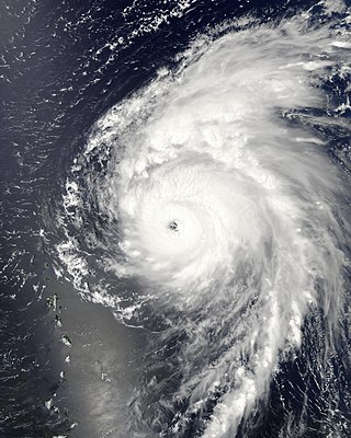
Hurricane Bill was a large Atlantic hurricane that brought minor damage across mainly Atlantic Canada and the East Coast of the United States during August 2009. The second named storm, first hurricane, and first major hurricane of the 2009 Atlantic hurricane season, Bill originated from a tropical wave in the eastern Atlantic on August 15. Initially a tropical depression, the cyclone intensified within a favorable atmospheric environment, becoming Tropical Storm Bill six hours after formation. Steered west-northwest around the southern periphery of a subtropical ridge to the northeast of the cyclone, Bill passed through the central Atlantic. At 0600 UTC on August 17, the cyclone strengthened into a Category 1 hurricane on the Saffir–Simpson hurricane wind scale; within 36 hours, Bill entered a period of rapid deepening and intensified into a major hurricane with winds of 115 mph (185 km/h). Passing well northeast of the Lesser Antilles, Bill attained its peak intensity with maximum sustained winds of 130 mph (215 km/h) and a minimum barometric pressure of 943 mb on August 19 and August 20, respectively. Thereafter, an approaching trough induced higher vertical wind shear across the region, causing slow weakening of the hurricane; this same trough resulted in an accelerated motion and curve northward. As the storm passed Bermuda, it contained sustained winds equal to a Category 2, and ultimately struck Newfoundland as a tropical storm. After moving inland and weakening to a tropical storm, Bill began an extratropical transition; this alteration in structure was completed by 1200 UTC on August 24. Two days later, Bill's remnant low was absorbed into a larger extratropical system over the Northern Atlantic.
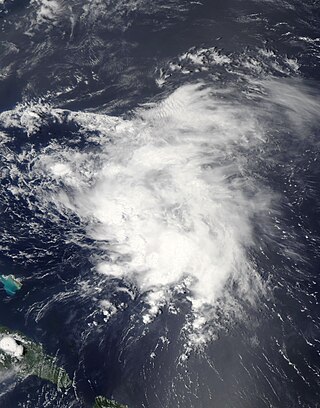
Tropical Storm Danny was a weak and disorganized tropical cyclone that formed in August 2009. The fifth tropical depression and fourth named storm of the 2009 Atlantic hurricane season, Danny developed on August 26 from the interaction between a westward-moving tropical wave and an upper-level trough while situated east of the Bahamas. The storm never fully matured, and resembled a subtropical cyclone. It meandered generally northwestward before being absorbed into another weather system on August 29.


