
The 2005 Pacific hurricane season was a near-average season which produced fifteen named storms, only seven hurricanes formed and two major hurricanes. It was also the second consecutive season in which no tropical cyclone of at least tropical storm intensity made landfall. The season officially began on May 15 in the East Pacific Ocean, and on June 1 in the Central Pacific; they ended on November 30. These dates conventionally delimit the period of each year when most tropical cyclones form in the Pacific basin. However, the formation of tropical cyclones is possible at any time of the year.

The 2008 Atlantic hurricane season was the most destructive Atlantic hurricane season since 2005, causing over 1,000 deaths and nearly $50 billion in damage. The season ranked as the third costliest ever at the time, but has since fallen to ninth costliest. It was an above-average season, featuring sixteen named storms, eight of which became hurricanes, and five which further became major hurricanes. It officially started on June 1 and ended on November 30. These dates conventionally delimit the period of each year when most tropical cyclones form in the Atlantic basin. However, the formation of Tropical Storm Arthur caused the season to start one day early. It was the only year on record in which a major hurricane existed in every month from July through November in the North Atlantic. Bertha became the longest-lived July tropical cyclone on record for the basin, the first of several long-lived systems during 2008.

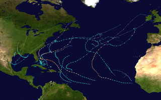
The 2005 Atlantic hurricane season was an event in the annual tropical cyclone season in the north Atlantic Ocean. It was the second most active Atlantic hurricane season in recorded history, and the most extreme in the satellite era. Officially, the season began on June 1, 2005 and ended on November 30, 2005. These dates, adopted by convention, historically delimit the period in each year when most tropical systems form. The season's first storm, Tropical Storm Arlene, developed on June 8. The final storm, Tropical Storm Zeta, formed in late December and persisted until January 6, 2006. Zeta is only the second December Atlantic storm in recorded history to survive into January, joining Hurricane Alice in 1955.

The 2008 Pacific hurricane season was a near-average Pacific hurricane season which featured seventeen named storms, though most were rather weak and short-lived. Only seven hurricanes formed and two major hurricanes. This season was also the first since 1996 to have no cyclones cross into the central Pacific. The season officially began on May 15 in the eastern Pacific and on June 1 in the central Pacific. It ended in both regions on November 30. These dates, adopted by convention, historically describe the period in each year when most tropical cyclone formation occurs in these regions of the Pacific. This season, the first system, Tropical Storm Alma, formed on May 29, and the last, Tropical Storm Polo, dissipated on November 5.
The 2008 Atlantic hurricane season was an event in the annual tropical cyclone season in the north Atlantic Ocean. An above-average Atlantic hurricane season season, it was the first on record to have a major hurricane in every month from July to November.

The 2017 Pacific hurricane season was an above average Pacific hurricane season in terms of named storms, though less active than the previous three, featuring eighteen named storms, nine hurricanes, and four major hurricanes. Despite the considerable amount of activity, most of the storms were weak and short-lived. The season officially started on May 15 in the eastern Pacific Ocean, and on June 1 in the central Pacific; they both ended on November 30. These dates conventionally delimit the period of each year when most tropical cyclones form in the respective regions. However, the formation of tropical cyclones is possible at any time of the year, as illustrated in 2017 by the formation of the season's first named storm, Tropical Storm Adrian, on May 9. At the time, this was the earliest formation of a tropical storm on record in the eastern Pacific basin proper. The season saw near-average activity in terms of accumulated cyclone energy (ACE), in stark contrast to the extremely active seasons in 2014, 2015, and 2016; and for the first time since 2012, no tropical cyclones formed in the Central Pacific basin. However, for the third year in a row, the season featured above-average activity in July, with the ACE value being the fifth highest for the month. Damage across the basin reached $375.28 million (2017 USD), while 45 people were killed by the various storms.

The 2014 Atlantic hurricane season was a below-average hurricane season in terms of named storms and major hurricanes, though average in terms of number of hurricanes overall. It produced nine tropical cyclones, eight of which became named storms; six storms became hurricanes and two intensified further into major hurricanes. The season officially began on June 1, and ended on November 30. These dates historically describe the period each year when most tropical cyclones form in the Atlantic basin. The first storm of the season, Arthur, developed on July 1, while the final storm, Hanna, dissipated on October 28, about a month prior to the end of the season. 2014 is the most recent year with a below average number of named Atlantic storms.

The 2016 Atlantic hurricane season was the deadliest Atlantic hurricane season since 2008, and the first above-average hurricane season since 2012, producing 15 named storms, 7 hurricanes and 4 major hurricanes. The season officially started on June 1 and ended on November 30, though the first storm, Hurricane Alex which formed in the Northeastern Atlantic, developed on January 12, being the first hurricane to develop in January since 1938. The final storm, Otto, crossed into the Eastern Pacific on November 25, a few days before the official end. Following Alex, Tropical Storm Bonnie brought flooding to South Carolina and portions of North Carolina. Tropical Storm Colin in early June brought minor flooding and wind damage to parts of the Southeastern United States, especially Florida. Hurricane Earl left 94 fatalities in the Dominican Republic and Mexico, 81 of which occurred in the latter. In early September, Hurricane Hermine, the first hurricane to make landfall in Florida since Hurricane Wilma in 2005, brought extensive coastal flooding damage especially to the Forgotten and Nature coasts of Florida. Hermine was responsible for five fatalities and about $550 million (2016 USD) in damage.
The 2019 Atlantic hurricane season was the fourth consecutive above-average and damaging season dating back to 2016. However, many storms were weak and short-lived, especially towards the end of the season. Six of those named storms achieved hurricane status, while three intensified into major hurricanes. Two storms became Category 5 hurricanes, marking the fourth consecutive season with at least one Category 5 hurricane, the third consecutive season to feature at least one storm making landfall at Category 5 intensity, and the seventh on record to have multiple tropical cyclones reaching Category 5 strength. The season officially began on June 1 and ended on November 30. These dates historically describe the period each year when most tropical cyclones form in the Atlantic basin and are adopted by convention. However, tropical cyclogenesis is possible at any time of the year, as demonstrated by the formation of Subtropical Storm Andrea on May 20, making this the fifth consecutive year in which a tropical or subtropical cyclone developed outside of the official season.

The 2020 Atlantic hurricane season was the most active Atlantic hurricane season on record, in terms of number of systems. It featured a total of 31 tropical or subtropical cyclones, with all but one cyclone becoming a named storm. Of the 30 named storms, 14 developed into hurricanes, and a record-tying seven further intensified into major hurricanes. It was the second and final season to use the Greek letter storm naming system, the first being 2005, the previous record. Of the 30 named storms, 11 of them made landfall in the contiguous United States, breaking the record of nine set in 1916. During the season, 27 tropical storms established a new record for earliest formation date by storm number. This season also featured a record ten tropical cyclones that underwent rapid intensification, tying it with 1995, as well as tying the record for most Category 4 hurricanes in a singular season in the Atlantic Basin. This unprecedented activity was fueled by a La Niña that developed in the summer months of 2020, continuing a stretch of above-average seasonal activity that began in 2016. Despite the record-high activity, this was the first season since 2015 in which no Category 5 hurricane formed.

The 2013 Atlantic hurricane season was an event in the annual hurricane season in the north Atlantic Ocean. It featured below-average tropical cyclone activity, with the fewest hurricanes since the 1982 season. The season officially began on June 1, 2013 and ended on November 30, 2013. These dates, adopted by convention, historically delimit the period in each year when most tropical systems form. The season's first storm, Tropical Storm Andrea formed on June 5, and its final storm, an unnamed subtropical storm, dissipated on December 7. Altogether, there were 13 named tropical storms during the season. Two of which attained hurricane strength, but neither intensified into a major hurricane, the first such occurrence since the 1994 season.

Hurricane Bertha was an unusual tropical cyclone in early August 2014 that attained hurricane status, despite having a disheveled appearance and an abnormally high atmospheric pressure. The third tropical cyclone and second hurricane of the season, Bertha developed from a tropical wave south of Cape Verde was monitored first for possible tropical cyclogenesis on July 26. Over the following days, it slowly developed and acquired gale-force winds and enough convection to be designated as Tropical Storm Bertha early on August 1. A mostly disorganized cyclone, Bertha quickly moved across the Lesser Antilles, clipping the northern end of Martinique, later that day. During its trek across the eastern Caribbean Sea, its circulation became severely disrupted and it may have degenerated into a tropical wave. On August 3, it traversed the Mona Passage and moved over the Southeastern Bahamas where conditions favored development. Despite an overall ragged appearance on satellite imagery, data from Hurricane Hunters indicated it intensified to a hurricane on August 4; it acquired peak winds of 80 mph (130 km/h) that day. Turning north, and later northeast, Bertha soon weakened as it began to merge with an approaching trough to the west. This merger ultimately took place on August 6, at which time Bertha was declared extratropical well to the south of Nova Scotia. The remnant system raced eastward across the Atlantic and later struck the United Kingdom on August 10. Once over the North Sea, the storm stalled for a few days before resuming its eastward track. It was last noted around the Baltic Sea on August 16.

Tropical Storm Bonnie was a weak but persistent tropical cyclone that brought heavy rains to the Southeastern United States in May 2016. The second storm of the season, Bonnie formed from an area of low pressure northeast of the Bahamas on May 27, a few days before the official hurricane season began on June 1. Moving steadily west-northwestwards, Bonnie intensified into a tropical storm on May 28 and attained peak winds six hours later. However, due to hostile environmental conditions, Bonnie weakened to a depression hours before making landfall just east of Charleston, South Carolina, on May 29. Steering currents collapsed afterwards, causing the storm to meander over South Carolina for two days. The storm weakened further into a post-tropical cyclone on May 31, before emerging off the coast while moving generally east-northeastwards. On June 2, Bonnie regenerated into a tropical depression just offshore North Carolina as conditions became slightly more favorable. The next day, despite increasing wind shear and cooling sea surface temperatures, Bonnie reintensified into a tropical storm and reached its peak intensity. The storm hung on to tropical storm strength for another day, before weakening into a depression late on June 4 and became post-tropical early the next day.
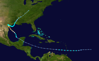
Hurricane Harvey was the costliest tropical cyclone on record, inflicting roughly $125 billion in damage across the Houston metropolitan area and Southeast Texas. It lasted from mid-August until early September 2017, with many records for rainfall and landfall intensity set during that time. The eighth named storm, third hurricane, and first major hurricane of the 2017 Atlantic hurricane season, Harvey originated from a broad area of low pressure southwest of Cape Verde that was first monitored on August 13. Tracking steadily westward, the disturbance developed strong convection, a well-defined circulation, and sustained tropical storm-force winds, leading to the classification of Tropical Storm Harvey late on August 17. Moderate easterly vertical wind shear kept Harvey weak, as it continued westwards into the Caribbean Sea; despite repeated predictions for gradual intensification by the National Hurricane Center, Harvey eventually opened up into a tropical wave on August 19. The remnants of Harvey continued to move westwards and reached the Yucatán Peninsula on August 22, and were forecast to regenerate into a tropical cyclone after exiting land.

The 2023 Atlantic hurricane season is the current hurricane season in the Atlantic Ocean in the Northern Hemisphere. It officially began on June 1, and will end on November 30. These dates, adopted by convention, historically describe the period in each year when most tropical cyclogenesis occurs in the Atlantic. However, the formation of subtropical or tropical cyclones is possible at any time of the year, as demonstrated by the formation of a subtropical storm on January 16, the earliest start of an Atlantic hurricane season since Hurricane Alex in 2016. This system went unnamed operationally, as the National Hurricane Center (NHC) treated it as non-tropical.

The 2021 Pacific hurricane season was a moderately active Pacific hurricane season, with above-average activity in terms of number of named storms, but below-average activity in terms of major hurricanes, with 19 named storms, 8 hurricanes, and 2 major hurricanes forming in all. It also had a near-normal accumulated cyclone energy (ACE). The season officially began on May 15, 2021 in the Eastern Pacific Ocean, and on June 1, 2021, in the Central Pacific in the Northern Hemisphere. The season ended in both regions on November 30, 2021. These dates historically describe the period each year when most tropical cyclogenesis occurs in these regions of the Pacific and are adopted by convention. However, the formation of tropical cyclones is possible at any time of the year, as illustrated by the formation of Tropical Storm Andres on May 9, which was the earliest forming tropical storm on record in the Eastern Pacific. Conversely, 2021 was the second consecutive season in which no tropical cyclones formed in the Central Pacific.

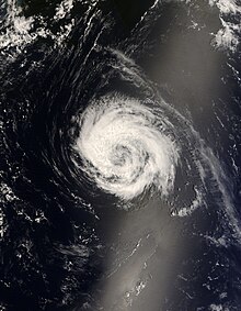
Hurricane Paulette was a strong and long-lived Category 2 Atlantic hurricane which became the first to make landfall in Bermuda since Hurricane Gonzalo did so in 2014. The sixteenth named storm and sixth hurricane of the record-breaking 2020 Atlantic hurricane season, Paulette developed from a tropical wave that left the coast of Africa on September 2. The wave eventually consolidated into a tropical depression on September 7. Paulette fluctuated in intensity over the next few days, due to strong wind shear, initially peaking as a strong tropical storm on September 8. It eventually strengthened into a hurricane early on September 13 as shear decreased. On September 14, Paulette made landfall in northeastern Bermuda as a Category 2 hurricane, while making a gradual turn to the northeast. The cyclone further strengthened as it moved away from the island, reaching its peak intensity with 1-minute sustained winds of 105 mph (169 km/h) and a minimum central atmospheric pressure of 965 mbar (28.5 inHg) on September 14. On the evening of September 15, Paulette began to weaken and undergo extratropical transition, which it completed on September 16. The hurricane's extratropical remnants persisted and moved southward then eastward, and eventually, Paulette regenerated into a tropical storm early on September 20 south of the Azores– which resulted in the U.S National Weather Service coining the phrase "zombie storm" to describe its unusual regeneration. Paulette's second phase proved short-lived, however, as the storm quickly weakened and became post-tropical again two days later. The remnant persisted for several days before dissipating south of the Azores on September 28. In total, Paulette was a tropical cyclone for 11.25 days, and the system had an overall lifespan of 21 days.

Hurricane Chris was a moderately strong tropical cyclone that affected the East Coast of the United States and Atlantic Canada in July 2018. The third tropical or subtropical cyclone, third named storm, and second hurricane of the 2018 Atlantic hurricane season, Chris originated from a frontal system that moved offshore the coast of the northeastern United States on June 29. The front evolved into a non-tropical low by July 3. After further organization, a tropical depression formed on July 6, several hundred miles south-southeast of Cape Hatteras, North Carolina. Two days later, the depression strengthened into a tropical storm and received the name Chris. Chris slowly strengthened as it drifted into warmer waters. These favorable conditions allowed Chris to rapidly intensify into a hurricane on July 10. The hurricane reached its peak intensity with winds of 105 mph (165 km/h) and a pressure of 969 mbar (28.61 inHg) at. This peak intensity was short-lived though, as Chris began to undergo extratropical transition. At 12:00 UTC on July 12, Chris became an extratropical cyclone well southeast of Newfoundland. The low continued northeastward over the Atlantic for the next few days, before weakening and finally dissipating southeast of Iceland on July 17.

Hurricane Epsilon was a strong tropical cyclone that affected Bermuda, and parts of North America and Western Europe. The twenty-seventh tropical or subtropical cyclone, twenty-sixth named storm, eleventh hurricane, and fourth major hurricane of the extremely-active 2020 Atlantic hurricane season, Epsilon had a non-tropical origin, developing from an upper-level low off the East Coast of the United States on October 13. The low gradually organized, becoming Tropical Depression Twenty-Seven on October 19, and six hours later, Tropical Storm Epsilon. The storm executed a counterclockwise loop before turning westward, while strengthening. On October 20, Epsilon began undergoing rapid intensification, becoming a Category 1 hurricane on the next day, before peaking as a Category 3 major hurricane on October 22, with maximum 1-minute sustained winds of 115 mph (185 km/h) and a minimum central pressure of 952 millibars (28.1 inHg). This made Epsilon the easternmost major hurricane this late in the calendar year, as well as the strongest late-season major hurricane in the northeastern Atlantic, and the fastest recorded case of a tropical cyclone undergoing rapid intensification that far northeast that late in the hurricane season. Afterward, Epsilon began to weaken as the system turned northward, with the storm dropping to Category 1 intensity late that day. Epsilon maintained its intensity as it moved northward, passing to the east of Bermuda. On October 24, Epsilon turned northeastward and gradually accelerated, before weakening into a tropical storm on the next day. On October 26, Epsilon transitioned into an extratropical cyclone, before being absorbed by another larger extratropical storm later that same day.

Tropical Storm Danny was a weak and short-lived tropical cyclone that caused minor damage to the U.S. states of South Carolina and Georgia. The fourth named storm of the 2021 Atlantic hurricane season, the system formed from an area of low-pressure that developed from an upper-level trough over the central Atlantic Ocean on June 22. Moving west-northwestward, the disturbance gradually developed as convection, or showers and thunderstorms, increased over it. Although it was moving over the warm Gulf Stream, the organization of the disturbance was hindered by strong upper-level wind shear. By 18:00 UTC of June 27, as satellite images showed a well-defined center and thunderstorms, the system was upgraded to a tropical depression by the National Hurricane Center (NHC). At 06:00 UTC on the next day, the system further strengthened into Tropical Storm Danny east-southeast of Charleston, South Carolina. Danny continued its track towards South Carolina while slowly strengthening, subsequently reaching its peak intensity at that day of 45 mph (72 km/h) and a minimum central pressure of 1,009 mbar (29.8 inHg) at 18:00 UTC. Danny then made landfall in Pritchards Island, north of Hilton Head, in a slightly weakened state at 23:20 UTC on the same day, with winds of 40 mph (64 km/h) and indicating that Danny weakened prior to moving inland. The system then weakened to a tropical depression over east-central Georgia, before dissipating shortly afterward.


