Hurricane Gordon (2006)

Last updated

Map key
  Tropical depression (≤38 mph, ≤62 km/h)
  Tropical storm (39–73 mph, 63–118 km/h)
  Category 1 (74–95 mph, 119–153 km/h)
  Category 2 (96–110 mph, 154–177 km/h)
  Category 3 (111–129 mph, 178–208 km/h)
  Category 4 (130–156 mph, 209–251 km/h)
  Category 5 (≥157 mph, ≥252 km/h)
  Unknown
Storm type
Disc Plain black.svg Tropical cyclone
Solid black.svg Subtropical cyclone
ArrowUp.svg Extratropical cyclone, remnant low, tropical disturbance, or monsoon depression

On September 1, a tropical wave exited the west coast of Africa and quickly showed signs of organization. It possessed a low pressure area and some convection as the system moved generally westward. [1] The United States National Hurricane Center (NHC) first pinpointed the system as an area for potential development late on September 2 while it was about 1,210 km (750 mi) west-southwest of Cape Verde. [2] However, an upper level trough associated with the developing Hurricane Florence to its west increased wind shear across the region, which prevented significant tropical cyclone development over the next week. [1] However, on September 5, the NHC noted the potential for the storm system to organize into a tropical depression within the next several days, [3] but its close proximity to Florence continued to stall its strengthening. [4] By September 9, the trough moved far enough away from the system to allow wind shear to yield, signalling an increase in convective thunderstorm activity. Around 18:00 UTC that day, the system developed into a tropical depression about 870 km (540 mi) east-northeast of the Lesser Antilles. [1]

Upon developing, the depression, small in physical size, moved slowly west-north-westward. Initially, the NHC faced difficulties in forecasting the future of the system due to the potential for resumed strong wind shear, as well as uncertainty in its path of direction. [5] It gradually organized and intensified, and based on observations from the Hurricane Hunters, the NHC assessed the depression as a tropical storm late on September 11; upon doing so, they named it Gordon. As it strengthened, Gordon developed more large outflow and increasing banding features. [6] On September 12, the storm slowed and turned toward the north through a weakness in the subtropical ridge created by Florence. Wind shear decreased further, [1] and the storm's convection became more symmetric with an intermittent eye feature in the center. Based on the presence of the eye and estimates from satellite imagery, it is estimated that Gordon intensified into a hurricane early on September 13. [7]

Hurricane Gordon as seen from Space Shuttle Atlantis (STS-115) on September 17 Gordon STS-115 70 kt.jpg
Hurricane Gordon as seen from Space Shuttle Atlantis (STS-115) on September 17

After becoming a hurricane, Gordon underwent rapid deepening as the eye became better defined and more intense. In 24 hours, the winds increased by 72 km/h (45 mph) to a peak intensity of 195 km/h (121 mph) early on September 14, while located about 925 km (575 mi) southeast of Bermuda. This made Gordon a major hurricane, specifically a Category 3 on the Saffir-Simpson scale, the first of 2006. [8] As it curved to the northeast, the hurricane maintained its peak intensity for about 24 hours, during which the eye decreased in size and the eyewall convection weakened. [1] Afterward, Gordon began weakening due to moving over an area of cooler water temperatures. [9] On September 15, the trough that was previously guiding the hurricane moved farther away, allowing the ridge to build to the north and causing Gordon's motion to become nearly stationary. Increased wind shear imparted further weakening, and the hurricane's slow motion resulted in upwelling  the motion of cooler water to the ocean's surface. On September 17, a building ridge to the east caused Gordon to begin a steady northeast motion. By that time, the convection had diminished significantly and the winds weakened to minimal hurricane-force. [1] One NHC forecast predicted extratropical transition to occur within 48 hours. [10]

Hurricanes Gordon (top) and Helene on September 18 Gordon and Helene 18 sept 2006.jpg
Hurricanes Gordon (top) and Helene on September 18

On September 18, Hurricane Gordon began accelerating to the northeast around a strengthening ridge, and later toward the east as guided by a trough. Wind shear decreased, which allowed for convection to redevelop near the eye. Unexpectedly, the hurricane began restrengthening, despite moving over slightly cooler waters; instability from cooler upper-level temperatures allowed for the reintensification. [1] Despite continued forecasts of a weakening trend, Gordon's resiliency presented a rare threat the first since Hurricane Charley in 1992 to the Azores, a Portuguese archipelago in the northeast Atlantic Ocean. [11] At about 06:00 UTC on September 19, the hurricane attained its secondary peak intensity of 169 km/h (105 mph) about 775 km (482 mi) west-southwest of the Azores. [1] By that time, the cyclone consisted of a solid ring of convection around a contracting eye. [11] Shortly thereafter, Gordon began steadily weakening due to the combination of increasing wind shear and even cooler water temperatures. Its motion became just south of due east, causing the strongest winds to remain south of the islands. Around 09:00 UTC on September 20, Gordon passed through the Azores between the islands of Santa Maria and São Miguel, producing hurricane-force wind gusts on the former island. At the time, its sustained winds were estimated around 121 km/h (75 mph), which remained south of any landmasses. [1] The cloud pattern had become less organized and more ragged. [12]

After passing the Azores, Gordon began interacting with an approaching cold front. Early on September 21, it completed the transition into an extratropical storm while simultaneously weakening below hurricane-force, located about 443 km (275 mi) west-northwest of the west coast of Portugal. The cyclone maintained its identity as the system turned sharply northeastward and later northward, after passing about 160 km (99 mi) northwest of the Spanish province of Galicia. Its forward motion accelerated to about 97 km/h (60 mph), steered by another extratropical storm, while still maintaining sustained winds of 105 km/h (65 mph). After moving along the west coast of Ireland, the extratropical remnants of Gordon turned to the northwest and intensified to hurricane-force winds. It turned to the southwest and later to the southeast, completing a large cyclonic loop before dissipating on September 24 to the south of Ireland. [1]

Preparations and impact

Hurricane Gordon
Hurricane Gordon 2006.jpg
Gordon at peak intensity on September 14
Wettest tropical cyclones and their remnants in the United Kingdom
Highest-known totals
PrecipitationStormLocationRef.
Rankmmin
1150.05.91 Bertha 2014 Inverness, Highland [13]
2135.05.31 Charley 1986 Abergwyngregyn, Gwynedd [14]
3130.05.12 Nadine 2012 Ravensworth, North Yorkshire [15]
476.02.99 Lili 1996 Chale Bay, Isle of Wight [16]
561.72.43 Zeta 2020 Chipping, Lancashire [17]
648.81.92 Grace 2009 Capel Curig, Conwy [18]
742.21.66 Gordon 2006 Wainfleet All Saints, Lincolnshire [19]
838.01.50 Gonzalo 2014 Glenmoriston, Highland [20]
931.01.22 Bill 2009 Shap, Cumbria [21]
1030.01.18 Laura 2008 Windermere, Cumbria [22]

Late on September 18, while Gordon was beginning to accelerate to the northeast, a tropical storm watch was issued for all of the Azores. The hurricane was expected to weaken to tropical storm-force before affecting the islands. When it became apparent that Gordon would continue intensifying, a hurricane warning replaced the watch about 27 hours before the strongest winds affected the region. [1] The advance of the storm forced the closure of all schools in the region. Concurrently, officials increased the number of emergency workers on stand-by. The two westernmost islands  Corvo and Flores  were placed under a red alert, the highest on a four-level scale, which indicated the greatest threat for severe weather. The remainder of the archipelago was placed on low alert. [23] Ultimately, the Azores escaped significant damage as the hurricane passed farther south than expected. Overall impact was limited to toppled trees and power lines, leaving portions of Santa Maria Island without electrical service. [24] Santa Maria recorded sustained winds of 56 mph (90 km/h), with gusts to 82 mph (132 km/h). [1]

Wind damage from the remnants of Hurricane Gordon in Ferrol, Spain 21-S.JPG
Wind damage from the remnants of Hurricane Gordon in Ferrol, Spain

In Portugal, coastal regions were put under a yellow alert, the second lowest level, since the extratropical remnants of Gordon were expected to produce rough seas and heavy rains. [25] In Spain, the Galicia region was placed on red alert by authorities in anticipation of the storm. Classes on September 21 were also suspended by the regional education ministry. Eleven other regions of Spain, extending as far east as Madrid and as far south as Andalusia, received lower levels of warning. [26] The storm's threat also prompted the cancellation or delay of flights along the coast. [27] While passing northwest of Spain, the remnants of Gordon produced strong wind gusts, reaching 183 km/h (114 mph) at Punta Candieira in Galicia on the country's northwest coast. The nearby city of A Coruña recorded sustained winds of 43 mph (69 km/h), [1] while further inland, a station near Madrid reported winds of 107 km/h (66 mph). Along the coast, waves reached 7 m (23 ft) in height, while rainbands dropped heavy precipitation, including a total of 65.5 mm (2.58 in) in Canfranc. [28] Wind-blown debris injured four people in the country, [1] and a fifth storm-related injury occurred as the result of a tree falling onto an occupied vehicle. The winds downed trees, traffic lights, and power lines, [27] leaving about 100,000 people without power. [1] [27] Throughout Galicia, total monetary losses reached 3 million (US$3.8 million; 2006 USD). [29]

Stormy conditions threatened to affect the 2006 Ryder Cup in Straffan, County Kildare, Ireland at the K Club, and September 25 was set aside as an additional "reserve day". The club's media center was briefly evacuated, and one woman at the event was injured after being struck by a tree branch broken by the storm. [30] The remnants of Gordon caused stormy conditions that left at least 5,000 people without power in eastern and southern Ireland. One electric company had more than 400 workers on duty to restore power in affected areas. [31] High winds blowing down trees were responsible for power outages [32] which affected 126,000 people in Northern Ireland. [1]

The remnants of Gordon affected the United Kingdom with strong winds, including gusts to 97 km/h (60 mph) in the Isles of Scilly off the southwest coast and 81 mph (130 km/h) on the mainland. [1] The storm interfered with an archaeological excavation undertaken by Time Team at Mount Murray on the Isle of Man, which was broadcast as part of the first episode of the 14th series. [33] The storm system produced heavy precipitation and thunderstorms that caused localized flooding. Wainfleet, Lincolnshire recorded 42.2 mm (1.66 in) of rainfall, of which almost half fell within the span of an hour. [34] High winds delayed rail service, [35] and in Dawlish, the rail line was damaged by coastal flooding. More than 1,000 homes were left without power in Truro, Cornwall. [36] The storm brought moist air northward that contributed to record warm temperatures across portions of the UK. [37]

See also

Related Research Articles

<span class="mw-page-title-main">1992 Atlantic hurricane season</span> Hurricane season in the Atlantic Ocean

The 1992 Atlantic hurricane season was a significantly below average season in which only ten tropical or subtropical cyclones formed. Six became named tropical storms, of which four became hurricanes. Among the four was Hurricane Andrew, a major hurricane, and the costliest Atlantic hurricane on record at the time, surpassing Hugo of 1989. The season officially started on June 1 and officially ended on November 30. However, tropical cyclogenesis is possible at any time of the year, as demonstrated by formation in April of an unnamed subtropical storm in the central Atlantic. A June tropical depression caused flooding in Cuba and in Florida, where two people were killed. In August, Andrew struck the Bahamas, Florida, and Louisiana. In all, it caused $27.3 billion in damage, mostly in Florida, as well as 65 fatalities. The greatest impact was in South Florida, where the storm made landfall with 1-minute sustained winds of 175 mph (280 km/h).

<span class="mw-page-title-main">2006 Atlantic hurricane season</span> Hurricane season in the Atlantic Ocean

The 2006 Atlantic hurricane season was the least active since 1997 as well as the first season since 2001 in which no hurricanes made landfall in the United States, and was the first since 1994 in which no tropical cyclones formed during October. Following the intense activity of 2003, 2004, and 2005, forecasters predicted that the 2006 season would be only slightly less active. Instead, it turned out to be a below average season, as activity was slowed by a rapidly forming moderate El Niño event, the presence of the Saharan Air Layer over the tropical Atlantic, and the steady presence of a robust secondary high-pressure area to the Azores High centered on Bermuda. There were no tropical cyclones after October 2.

<span class="mw-page-title-main">Hurricane Erika (1997)</span> Category 3 Atlantic hurricane

Hurricane Erika was the strongest and longest-lasting tropical cyclone in the 1997 Atlantic hurricane season. It developed from a tropical wave on September 3 and moved west-northwestward across the tropical Atlantic Ocean, steadily intensifying until it attained hurricane status on September 4, becoming the fifth named storm and third hurricane of the season. Erika passed a short distance to the north of the Lesser Antilles, and later turned to the north in response to an approaching trough. The hurricane quickly strengthened to become the only major hurricane of the season, reaching maximum sustained winds of 125 mph (201 km/h) on September 8; after maintaining its peak strength for 24 hours, Erika began to weaken as it passed over cooler waters. It turned to the east, weakened to a tropical storm, and became extratropical after passing near the Azores archipelago.

<span class="mw-page-title-main">Tropical Storm Nicholas (2003)</span> Atlantic tropical storm in 2003

Tropical Storm Nicholas was a long-lived tropical storm in October and November of the 2003 Atlantic hurricane season. Forming from a tropical wave on October 13 in the central tropical Atlantic Ocean, Nicholas developed slowly due to moderate levels of wind shear throughout its lifetime. Deep convection slowly organized, and Nicholas attained a peak intensity of 70 mph (110 km/h) on October 17. After moving west-northwestward for much of its lifetime, it turned northward and weakened due to increasing shear. The storm again turned to the west and briefly restrengthened, but after turning again to the north Nicholas transitioned to an extratropical cyclone on October 24. As an extratropical storm, Nicholas executed a large loop to the west, and after moving erratically for a week and organizing into a tropical low, it was absorbed by a non-tropical low. The low continued westward, crossed Florida, and ultimately dissipated over the Gulf Coast of the United States on November 5.

<span class="mw-page-title-main">Subtropical Storm Nicole</span> Atlantic subtropical storm in 2004

Subtropical Storm Nicole was the first subtropical storm to receive a name using the standard hurricane name list that did not become a tropical cyclone. The fifteenth tropical or subtropical cyclone and fourteenth named storm of the 2004 Atlantic hurricane season, Nicole developed on October 10 near Bermuda from a broad surface low that developed as a result of the interaction between an upper level trough and a decaying cold front. The storm turned to the northeast, passing close to Bermuda as it intensified to reach peak winds of 50 mph (80 km/h) on October 11. Deep convection developed near the center of the system as it attempted to become a fully tropical cyclone. However, it failed to do so and was absorbed by an extratropical cyclone late on October 11.

<span class="mw-page-title-main">Hurricane Florence (2006)</span> Category 1 Atlantic hurricane in 2006

Hurricane Florence was the first North Atlantic hurricane to produce hurricane-force winds on the island of Bermuda since Hurricane Fabian in September 2003. The seventh tropical storm and second hurricane of the 2006 Atlantic hurricane season, Florence developed from a tropical wave in the eastern Atlantic Ocean on September 3. Due to unfavorable conditions, the system failed to organize initially, and as a result, the storm grew to an unusually large size. After several days, Florence encountered an area of lesser wind shear and intensified into a hurricane on September 10. It passed just west of Bermuda while recurving northeastward, and on September 13 it transitioned into an extratropical cyclone.

<span class="mw-page-title-main">Hurricane Helene (2006)</span> Category 3 Atlantic hurricane in 2006

Hurricane Helene was the ninth tropical storm, fourth hurricane, and strongest hurricane of the 2006 Atlantic hurricane season, tied with Hurricane Gordon.

<span class="mw-page-title-main">Hurricane Karen (2001)</span> Category 1 Atlantic hurricane in 2001

Hurricane Karen was a hurricane of non-tropical origin that formed in October of the 2001 Atlantic hurricane season. It developed out of the interaction between a cold front and an upper level trough on October 10 located to the south of Bermuda, and quickly strengthened as an extratropical storm. The storm passed near Bermuda on October 12, producing hurricane-force winds on the island. It then organized, becoming a subtropical cyclone on October 12 and a tropical cyclone on October 13. Karen strengthened to reach 80 mph (130 km/h) winds as a Category 1 hurricane on the Saffir-Simpson Hurricane Scale, and after weakening over cooler waters, it made landfall on Nova Scotia as a tropical storm. It quickly became extratropical.

<span class="mw-page-title-main">Tropical Storm Dean (2001)</span> Atlantic tropical storm in 2001

Tropical Storm Dean was a strong tropical storm that affected at least twelve islands along its path from the tropical Atlantic Ocean to east of Atlantic Canada in August 2001. Dean developed from a tropical wave on August 22 over the Lesser Antilles, and was initially predicted to intensify further to reach hurricane status. However, strong wind shear quickly weakened Dean to cause it to dissipate on August 23. The remnants turned northward, and redeveloped on August 26 to the north of Bermuda. Located over warm waters and in an area of favorable conditions, Dean steadily strengthened while moving to the northeast, and peaked just below hurricane status on August 27 about 465 miles (748 km) southwest of Newfoundland. The storm subsequently weakened over cooler waters, and became extratropical on August 28.

<span class="mw-page-title-main">2005 Azores subtropical storm</span> Unnamed Atlantic subtropical storm

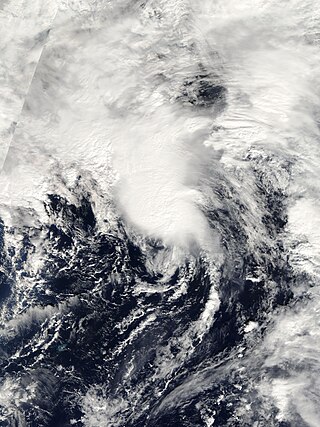
The 2005 Azores subtropical storm was the 19th nameable storm and only subtropical storm of the extremely active 2005 Atlantic hurricane season. It was not named by the National Hurricane Center as it was operationally classified as an extratropical low. It developed in the eastern Atlantic Ocean, an unusual region for late-season tropical cyclogenesis. Nonetheless, the system was able to generate a well-defined centre convecting around a warm core on 4 October. The system was short-lived, crossing over the Azores later on 4 October before becoming extratropical again on 5 October. No damages or fatalities were reported during that time. Its remnants were soon absorbed into a cold front. That system went on to become Hurricane Vince, which affected the Iberian Peninsula.

<span class="mw-page-title-main">Hurricane Bonnie (1992)</span> Category 2 Atlantic hurricane in 1992

Hurricane Bonnie was a long-lived storm in the 1992 Atlantic hurricane season. It was the third tropical or subtropical storm and second hurricane of the 1992 season. Bonnie formed at high latitudes in the central Atlantic on September 17. Devoid of any real steering currents for much of its lifespan, it was nearly stationary for over a week in the central Atlantic Ocean. On September 27, it began to slowly track east and northeast towards the Azores. Just before becoming extratropical, it affected the Azores on September 30, although no damage was reported.

<span class="mw-page-title-main">Hurricane Erin (2001)</span> Category 3 Atlantic hurricane

Hurricane Erin was the longest-lived hurricane in the 2001 Atlantic hurricane season. The sixth tropical depression, fifth tropical storm, and first hurricane of the season, Erin developed from a tropical wave on September 1. After strengthening to a 60 mph (97 km/h) tropical storm as it moved to the west-northwest, wind shear weakened Erin and caused it to degenerate into a remnant low on September 5. The remnants re-organized into a tropical depression the next day, and Erin strengthened into a hurricane on September 9 while moving northwestward. This was the latest date for the first hurricane of the season since Hurricane Diana on September 10, 1984. Erin quickly intensified and reached peak winds of 120 mph (190 km/h) later on September 9. At its closest approach, Erin passed 105 miles (169 km) east-northeast of Bermuda near peak intensity, and subsequently weakened as it turned to the east. A trough turned Erin to the northeast, and after passing just east of Cape Race, Newfoundland it became extratropical on September 15. The extratropical remnant continued northeastward and was absorbed into another extratropical storm near Greenland on September 17.

<span class="mw-page-title-main">Tropical Storm Grace (2009)</span> Atlantic tropical storm in 2009

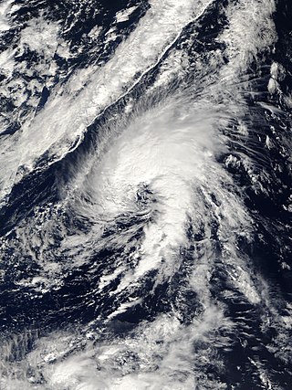
Tropical Storm Grace holds the record for being the farthest northeast forming tropical cyclone in the Atlantic basin. The seventh named storm of the slightly below average 2009 Atlantic hurricane season, Grace formed from an extratropical cyclone over the Azores on 4 October. It strengthened to attain peak sustained winds of 65 mph (100 km/h) and developed an eye-like feature, although cold sea surface temperatures inhibited the development of thunderstorm activity near the center. The storm lost its tropical characteristics on 6 October, and the storm's remnants merged with a separate system near the British Isles on 7 October.

<span class="mw-page-title-main">Hurricane Epsilon (2005)</span> Category 1 Atlantic hurricane in 2005

Hurricane Epsilon was the twenty-seventh named tropical or subtropical storm and the final of 15 hurricanes in the record-breaking 2005 Atlantic hurricane season. Originating from a cold front beneath an upper-level low, Epsilon formed on November 29 about 915 mi (1470 km) east of Bermuda, becoming the second tropical storm to do so in that area of the Atlantic within the span of a week. Initially, the National Hurricane Center (NHC) forecast the storm to transition into an extratropical cyclone within five days, due to conditions unfavorable for significant intensification. Epsilon continually defied forecasts, at first due to an unexpected loop to the southwest, and later due to retaining its strength despite cold waters and strong wind shear.

<span class="mw-page-title-main">Hurricane Katia (2011)</span> Category 4 Atlantic hurricane in 2011

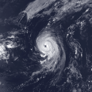
Hurricane Katia was a fairly intense Cape Verde hurricane that had substantial impact across Europe as a post-tropical cyclone. The eleventh named storm, second hurricane, and second major hurricane of the active 2011 Atlantic hurricane season, Katia originated as a tropical depression from a tropical wave over the eastern Atlantic on August 29. It intensified into a tropical storm the following day and further developed into a hurricane by September 1, although unfavorable atmospheric conditions hindered strengthening thereafter. As the storm began to recurve over the western Atlantic, a more hospitable regime allowed Katia to become a major hurricane by September 5 and peak as a Category 4 hurricane with winds of 140 mph (230 km/h) that afternoon. Internal core processes, increased wind shear, an impinging cold front, and increasingly cool ocean temperatures all prompted the cyclone to weaken almost immediately after peak, and Katia ultimately transitioned into an extratropical cyclone on September 10.

<span class="mw-page-title-main">Hurricane Nadine</span> Category 1 Atlantic hurricane in 2012

Hurricane Nadine was an erratic Category 1 hurricane that became the fourth-longest-lived Atlantic hurricane on record. As the fourteenth tropical cyclone and named storm of the 2012 Atlantic hurricane season, Nadine developed from a tropical wave traveling west of Cape Verde on September 10. On the following day, it had strengthened into Tropical Storm Nadine. After initially tracking northwestward, Nadine turned northward, well away from any landmass. Early on September 15, Nadine reached hurricane status as it was curving eastward. Soon after, an increase in vertical wind shear weakened Nadine and by September 16 it was back to a tropical storm. On the following day, the storm began moving northeastward and threatened the Azores but late on September 19, Nadine veered east-southeastward before reaching the islands. Nonetheless, the storm produced tropical storm force winds on a few islands. On September 21, the storm curved south-southeastward while south of the Azores. Later that day, Nadine transitioned into a extratropical low pressure area.

<span class="mw-page-title-main">Hurricane Alex (2016)</span> Category 1 Atlantic hurricane in 2016

Hurricane Alex was the first Atlantic hurricane to occur in January since Hurricane Alice of 1954–55. Alex originated as a non-tropical low near the Bahamas on January 7, 2016. Initially traveling northeast, the system passed by Bermuda on January 8 before turning southeast and deepening. It briefly acquired hurricane-force winds by January 10, then weakened slightly before curving towards the east and later northeast. Acquiring more tropical weather characteristics over time, the system transitioned into a subtropical cyclone well south of the Azores on January 12, becoming the first North Atlantic tropical or subtropical cyclone in January since Tropical Storm Zeta of 2005–2006. Alex continued to develop tropical features while turning north-northeast, and transitioned into a fully tropical cyclone on January 14. The cyclone peaked in strength as a Category 1 hurricane on the Saffir–Simpson scale (SSHWS), with maximum sustained winds of 85 mph and a central pressure of 981 mbar. Alex weakened to a high-end tropical storm before making landfall on Terceira Island on January 15. By that time, the storm was losing its tropical characteristics; it fully transitioned back into a non-tropical cyclone several hours after moving away from the Azores. Alex ultimately merged with another cyclone over the Labrador Sea on January 17.

<span class="mw-page-title-main">Hurricane Paulette</span> Category 2 Atlantic hurricane in 2020

Hurricane Paulette was a strong and long-lived Category 2 Atlantic hurricane which became the first to make landfall in Bermuda since Hurricane Gonzalo did so in 2014. The sixteenth named storm and sixth hurricane of the record-breaking 2020 Atlantic hurricane season, Paulette developed from a tropical wave that left the coast of Africa on September 2. The wave eventually consolidated into a tropical depression on September 7. Paulette fluctuated in intensity over the next few days, due to strong wind shear, initially peaking as a strong tropical storm on September 8. It eventually strengthened into a hurricane early on September 13 as shear decreased. On September 14, Paulette made landfall in northeastern Bermuda as a Category 2 hurricane, while making a gradual turn to the northeast. The cyclone further strengthened as it moved away from the island, reaching its peak intensity with 1-minute sustained winds of 105 mph (169 km/h) and a minimum central atmospheric pressure of 965 mbar (28.5 inHg) on September 14. On the evening of September 15, Paulette began to weaken and undergo extratropical transition, which it completed on September 16. The hurricane's extratropical remnants persisted and moved southward then eastward, and eventually, Paulette regenerated into a tropical storm early on September 20 south of the Azores– which resulted in the U.S National Weather Service coining the phrase "zombie storm" to describe its unusual regeneration. Paulette's second phase proved short-lived, however, as the storm quickly weakened and became post-tropical again two days later. The remnant persisted for several days before dissipating south of the Azores on September 28. In total, Paulette was a tropical cyclone for 11.25 days, and the system had an overall lifespan of 21 days.

<span class="mw-page-title-main">Hurricane Pablo</span> Category 1 Atlantic hurricane in 2019

Hurricane Pablo was a late-season Category 1 hurricane that became the farthest east-forming hurricane in the North Atlantic tropical cyclone basin on record, beating the previous record set by Hurricane Vince in 2005. The seventeenth tropical/subtropical cyclone and sixteenth named storm of the active 2019 Atlantic hurricane season, Pablo originated from a baroclinic cyclone a few hundred miles west of the Azores Islands. The precursor cyclone formed on October 22, traveling eastward towards the island chain. The system initially had multiple centers of circulation, but they consolidated into one small low-pressure system embedded within the larger extratropical storm. On October 25, the embedded cyclone developed into a subtropical cyclone, receiving the name Pablo. The cyclone continued eastwards, transitioning into a fully-tropical storm later that day. Pablo quickly intensified between October 26 and 27, forming an eye and spiral rainbands. At 12:00 Coordinated Universal Time (UTC) on October 27, Pablo intensified into a Category 1 hurricane. The storm continued to strengthen, reaching its peak intensity of 80 mph (130 km/h) and a minimum central pressure of 977 mbar (28.9 inHg) at 18:00 UTC on the same day. The storm quickly weakened the next day, becoming extratropical again, and dissipated on October 29.

References

  1. 1 2 3 4 5 6 7 8 9 10 11 12 13 14 15 16 17 Eric Blake (November 14, 2006). "Hurricane Gordon Tropical Cyclone Report" (PDF). National Hurricane Center. Retrieved May 3, 2011.
  2. Jack Beven (September 2, 2006). "Tropical Weather Outlook" (TXT). National Hurricane Center. Archived from the original on October 25, 2012. Retrieved May 3, 2011.
  3. Stacy Stewart (September 5, 2006). "Tropical Weather Outlook" (TXT). National Hurricane Center. Archived from the original on October 25, 2012. Retrieved May 3, 2011.
  4. Michelle Mainelli; Jack Beven (September 7, 2006). "Tropical Weather Outlook" (TXT). National Hurricane Center. Archived from the original on October 25, 2012. Retrieved May 3, 2011.
  5. Richard Knabb; Robbie Berg (September 11, 2006). "Tropical Depression Seven Discussion One". National Hurricane Center. Archived from the original on October 17, 2012. Retrieved May 3, 2011.
  6. Hugh Cobb; Richard Pasch (September 11, 2006). "Tropical Storm Gordon Discussion Four". National Hurricane Center. Archived from the original on October 17, 2012. Retrieved May 3, 2011.
  7. Lixion Avila (September 13, 2006). "Hurricane Gordon Discussion Nine". National Hurricane Center. Archived from the original on October 17, 2012. Retrieved May 3, 2011.
  8. Lixion Avila (September 15, 2006). "Hurricane Gordon Discussion Thirteen". National Hurricane Center. Archived from the original on January 10, 2014. Retrieved May 3, 2011.
  9. Michael Brennan; Richard Knabb (September 15, 2006). "Hurricane Gordon Discussion Eighteen". National Hurricane Center. Archived from the original on January 10, 2014. Retrieved May 3, 2011.
  10. Stacy Stewart (September 17, 2006). "Hurricane Gordon Discussion Twenty-Five". National Hurricane Center. Archived from the original on January 10, 2014. Retrieved May 3, 2011.
  11. 1 2 Eric Blake; Richard Pasch (September 19, 2006). "Hurricane Gordon Discussion Thirty-Three". National Hurricane Center. Archived from the original on January 10, 2014. Retrieved May 4, 2011.
  12. Richard Pasch (September 20, 2006). "Hurricane Gordon Discussion Thirty-Seven". National Hurricane Center. Archived from the original on January 10, 2014. Retrieved May 4, 2011.
  13. "Ex-hurricane Bertha" (PDF). Met Office. Met Office. Retrieved October 15, 2022.
  14. "Hydrological Data UK 1986 Yearbook" (PDF). Natural Environment Research Council. British Geological Survey Institute of Hydrology. Retrieved October 15, 2022.
  15. "Hydrological Summary for the United Kingdom - September 2012" (PDF). Natural Environment Research Council. British Geological Survey Institute of Hydrology. Retrieved October 15, 2022.
  16. David Longshore (1998). Encyclopedia of Hurricanes, Typhoons, and Cyclones, New Edition. New York: Facts on File. p. 110. ISBN   9781438118796 . Retrieved June 19, 2013.
  17. Finch, Fiona. "Warning over cost of record rainfall in Lancashire". Lancashire Post. Retrieved October 15, 2022.
  18. "Review of UK weather on 06/10/09". BBC Weather. October 7, 2009. Archived from the original on October 11, 2009. Retrieved October 7, 2009.
  19. "September 2006 UK Review". United Kingdom Met Office. 2006. Archived from the original on October 2, 2012. Retrieved May 9, 2011.
  20. "Top UK wind speeds as Gonzalo's remnants felt". Met Office Blog. Met Office. Retrieved October 15, 2022.
  21. Laura Harding (August 27, 2009). "More rain expected in parts of UK". The Independent. Retrieved November 19, 2009.
  22. "Tropical storm brings floods". Westmorland Gazette. Retrieved October 15, 2022.
  23. Staff Writer (September 18, 2006). "Portugal's Mid-Atlantic Azores Brace For Tropical Storm". Agence France-Presse. Archived from the original on March 9, 2012. Retrieved May 5, 2011.
  24. Staff Writer (September 20, 2006). "Azores escape worst of hurricane". BBC News. Archived from the original on January 2, 2014. Retrieved May 7, 2011.
  25. Alex Morales; Margot Habiby (September 20, 2006). "Hurricane Gordon Sweeps Through Azores, Heads Toward Iberia". Bloomberg News. Archived from the original on October 24, 2012. Retrieved May 11, 2011.
  26. Staff Writer (September 20, 2006). "Spain prepares for a weakened Gordon". Kansas City Star. Associated Press.
  27. 1 2 3 Staff Writer (September 21, 2006). "Storm Gordon reaches Spain – one injured". The Raw Story. Deutsche Presse Agentur. Archived from the original on January 2, 2014. Retrieved May 9, 2011.
  28. Agencia Estatal de Meteorología. "Las Consecuencias de Gordon en Espana" (PDF) (in Spanish). Government of Spain. Archived from the original (PDF) on October 4, 2006. Retrieved May 9, 2011.
  29. Unattributed (2006). "El Consorcio de Seguros tasa en unos 44 millones los daños por las inundaciones" (in Spanish). Farode Vigo. Archived from the original on May 27, 2013. Retrieved May 9, 2011.
  30. Staff Writer (September 21, 2006). "High winds lead to power failures". BBC News. Archived from the original on January 2, 2014. Retrieved May 9, 2011.
  31. Staff Writer (September 22, 2006). "Eircom & ESB working to restore services". RTÉ News and Current Affairs. Archived from the original on March 14, 2012. Retrieved May 9, 2011.
  32. Staff Writer (September 23, 2006). "Thousands of homes without power". BBC News. Archived from the original on September 10, 2020. Retrieved May 9, 2011.
  33. "Speke Keeill, Mount Murray Hotel, Isle of Man: Archaeological Evaluation and Assessment of Results" (PDF). Wessex Archaeology. Wessex Archaeology. Archived from the original (PDF) on March 5, 2016.
  34. "September 2006 UK Review". United Kingdom Met Office. 2006. Archived from the original on October 2, 2012. Retrieved May 9, 2011.
  35. Helen McKenzie (September 22, 2006). "Strong Winds Hit the UK". BBC World Weather News. Retrieved May 9, 2011.
  36. Staff Writer (September 22, 2006). "Storms hit power and rail tracks". BBC News. Archived from the original on September 10, 2020. Retrieved May 10, 2011.
  37. Lewis Smith and Paul Simons (September 22, 2006). "Gordon keeps the forecasters guessing". The Sunday Times. Archived from the original on September 10, 2020. Retrieved May 10, 2011.