Tudela, Misamis Occidental

Last updated
Tudela
Municipality of Tudela
Motto: 
Abante Tudela!
Ph locator misamis occidental tudela.png
Map of Misamis Occidental with Tudela highlighted
OpenStreetMap
Tudela, Misamis Occidental
Philippines location map (square).svg
Red pog.svg
Tudela
Location within the Philippines
Coordinates: 8°14′50″N123°50′33″E / 8.2472°N 123.8424°E / 8.2472; 123.8424
Country Philippines
Region Northern Mindanao
Province Misamis Occidental
District 2nd district
Founded December 28, 1920
Named for Tudela, Navarre
Barangays 33 (see Barangays)
Government
[1]
  Type Sangguniang Bayan
   Mayor Samuel “Sam” L. Parojinog (NP)
   Vice Mayor Estela “Cha-Cha” Obut-Estaño (PDPLBN)
   Representative Sancho Fernando “Ando” F. Oaminal (NP)
   Municipal Council
Members
   Electorate 19,010 voters (2022)
Area
[2]
  Total98.52 km2 (38.04 sq mi)
Elevation
44 m (144 ft)
Population
 (2020 census) [3]
  Total28,599
  Density290/km2 (750/sq mi)
   Households
7,123
Economy
   Income class 4th municipal income class
   Poverty incidence
24.38
% (2018) [4]
   Revenue 121 million (2020)
   Assets 546.7 million (2020)
   Expenditure 116.4 million (2020)
   Liabilities 97.91 million (2020)
Service provider
  ElectricityMisamis Occidental 2 Electric Cooperative (MOELCI 2)
Time zone UTC+8 (PST)
ZIP code
7202
PSGC
IDD : area code +63(0)88
Native languages Subanon
Cebuano
Tagalog
Website www.tudelamisocc.gov.ph

Tudela, officially the Municipality of Tudela, (Cebuano: Lungsod sa Tudela; Tagalog: Bayan ng Tudela), is a 4th class municipality in the province of Misamis Occidental, Philippines. According to the 2020 census, it has a population of 28,599 people. [3]

Contents

Tudela is widely known for its colorful and interesting Binalbal Festival, where many revelers are clad in very gory costumes like a giant Halloween costume party. [5] It is held every New Year's Day (Jan. 1). [6] Close to the border of Tudela is the eco-tourism attraction Misamis Occidental Aquamarine Park (MOAP), which is located in its boundary with Sinacaban, its neighboring town to the north.

History

Spanish colonial era

Founded by Padre Antonio Olleta as the visita of Tudela and by 1884 it was already a pueblo with four barrios. [7] Named after Tudela, Navarre, Spain, the hometown of Padre Olleta. [8]

American colonial era

The present territory of Tudela was once part of the former municipality of Loculan. [9] Through Act No. 951, issued by the Philippine Commission on October 21, 1903, which reduced the number of municipalities in the then-undivided Misamis province from 24 to 10, Loculan was effectively abolished after being joined with the municipality of Misamis. [10]

During the American occupation, the inhabitants in Loculan petitioned to be separated from Misamis and organized into two independent municipalities. Thus, Governor-General Francis Burton Harrison (through the efforts of Senator Jose F. Clarin) issued Executive Order (EO) No. 61 on December 28, 1920, creating the municipality of Tudela, along with Clarin; Barrio Tudela became the seat of government. The organization became effective on the first day of 1921. [9]

The first appointed Municipal President was Primitivo Ninang and its first Vice President was Pirigrin Sengidas. The following councilors appointed were Pio Adecir, Simeon Fuentes, Gregorio Madula, Casimeo Rubio, Julio Maliao, Florentino Olarte, Felix Codilla, and Isidro Sol.

The first appointed Municipal Secretary was Jose M. Castaños, known as “Secretario Municipal Interino”. The Provincial Fiscal nominated him and it was approved by Municipal Council Res. No. 123, series of 1923.

Spanish Language was used in the preparation of minutes, resolutions and ordinances from 1921 up to 1928 and in the later part of 1929 during the term of Ulpiano Balazo as Municipal President.

Territorial changes

Its territorial jurisdiction has been reduced. In April 1924, by virtue of EO No. 20, Barrio Balicaocao was transferred to Clarin. [11] In 1982, through Batas Pambansa Blg. 171, Barangays Tuno, Lalud, and Lampasan were annexed to the newly-created Don Mariano Marcos (now Don Victoriano Chiongbian) [12] [13]

Martial law

A notable incident in Tudela during the Marcos dictatorship took place on Aug. 24, 1981, when members of a pseudo-religious paramilitary sect strafed the house of the Gumapons, a Subanon family, in Sitio Gitason, Barrio Lampasan. Ten of the twelve persons in the house, including an infant, were killed. [14] [15]

Geography

Tudela is bounded on the north by the municipality of Sinacaban, to the south by the municipality of Clarin, to the east by Iligan Bay, and to the west by the municipality of Don Victoriano Chiongbian and Mount Malindang. It is 20-minute drive from Ozamiz City to the south, and 45-minutes drive from Oroquieta City to the north.

Barangays

Tudela is politically subdivided into 33 barangays. Each barangay consists of puroks while some have sitios.

  • Balon
  • Barra
  • Basirang
  • Bongabong
  • Buenavista
  • Cabol-anonan
  • Cahayag
  • Camating
  • Canibungan Proper
  • Casilak San Agustin
  • Centro Hulpa (Poblacion)
  • Centro Napu (Poblacion)
  • Centro Upper (Poblacion)
  • Colambutan Bajo
  • Colambutan Settlement
  • Duanguican
  • Gala
  • Gumbil
  • Locso-on
  • Maikay
  • Maribojoc
  • Mitugas
  • Nailon
  • Namut
  • Napurog
  • Pan-ay Diot
  • San Nicolas
  • Sebac
  • Silongon
  • Sinuza
  • Taguima
  • Tigdok
  • Yahong

Climate

Climate data for Tudela, Misamis Occidental
MonthJanFebMarAprMayJunJulAugSepOctNovDecYear
Mean daily maximum °C (°F)28
(82)
28
(82)
29
(84)
31
(88)
31
(88)
30
(86)
30
(86)
30
(86)
30
(86)
30
(86)
29
(84)
28
(82)
30
(85)
Mean daily minimum °C (°F)23
(73)
23
(73)
23
(73)
23
(73)
24
(75)
24
(75)
24
(75)
24
(75)
24
(75)
24
(75)
24
(75)
23
(73)
24
(74)
Average precipitation mm (inches)69
(2.7)
44
(1.7)
37
(1.5)
29
(1.1)
87
(3.4)
137
(5.4)
131
(5.2)
141
(5.6)
143
(5.6)
134
(5.3)
68
(2.7)
53
(2.1)
1,073
(42.3)
Average rainy days9.97.67.48.121.626.526.426.625.824.315.110.4209.7
Source: Meteoblue [16]

Demographics

Population census of Tudela
YearPop.±% p.a.
1939 11,057    
1948 11,477+0.42%
1960 13,361+1.27%
1970 17,877+2.95%
1975 19,625+1.89%
1980 21,893+2.21%
1990 19,070−1.37%
YearPop.±% p.a.
1995 22,805+3.41%
2000 23,047+0.23%
2007 25,113+1.19%
2010 27,371+3.18%
2015 28,932+1.06%
2020 28,599−0.23%
Source: Philippine Statistics Authority [17] [18] [19] [20]

In the 2020 census, the population of Tudela, Misamis Occidental, was 28,599 people, [3] with a density of 290 inhabitants per square kilometre or 750 inhabitants per square mile.

Religion

Places of worship:

Economy

Poverty Incidence of Tudela

10
20
30
40
50
2006
43.70
2009
38.01
2012
38.07
2015
34.49
2018
24.38
2021
23.48

Source: Philippine Statistics Authority [21] [22] [23] [24] [25] [26] [27] [28]

The majority hardly depends on agriculture and fishing. Commerce is also progressive in this municipality. There are many Tudelanhon businessmen. People in the municipality and of the neighboring barangays of Clarin and Sinacaban towns depend on the local market, instead of going to Ozamiz City, the economic hub in the province.

Crops: Palay, corn, banana, kamoteng-kahoy (cassava), sweet potato, coconut, fruits (mango, durian, lanzones), and vegetables.

Products: aquaculture products: shrimps, prawns, crabs, tilapia, bangus (milkfish); furniture; poultry products; breads and pastries; fishes and shells.

Tourism

Government

The governance of the Municipality of Tudela was managed by elected, appointed and OIC Mayors from 1921 up to the present, as follows:

Infrastructure

Transportation

Air
Tudela is accessible by plane and served by Ozamiz City Airport, a short ride of tricycle from the airport to the Ozamiz City Integrated Bus Terminal (IBJT) also known as "Agora Terminal" where a Tudela modified public utility vehicle called "balik-balik" awaits and bound to Tudela.:
Sea
Served by Port of Ozamiz City, then same as at the airport scenario which you have to ride a tricycle going to the Agora Terminal and another ride on a balik-balik bound for Tudela.:
Land
The public mode of transportation within this municipality is usually by tricycle and habal-habal, while the balik-balik is a means of transport to and fro Ozamiz City, the nearest city.:

Utilities

Communication
Telecommunications and internet are available. Mobile phone networks (Smart, Globe, Sun Cellular (now part of Smart) [29] and Dito Telecommunity) operate extensively in the municipality.:
PhilPost has its office in the Municipal Hall. Most of the municipality is serviceable by commercial couriers (e.g. LBC, JRS Express, Air21, 2GO, etc.) based in Ozamiz City.
Electricity
All 33 barangays were energized by Misamis Occidenta II Electric Cooperative, Inc. (MOELCI II)].:
Water
Poblacion area is served by Misamis Occidental Water District (MOWD). [30] Rural barangays have their own water systems funded by the government.

Education

Preschool

Every barangay in the municipality has their own Day Care Center under the supervision of the Department of Social Welfare and Development.

Elementary

Secondary

Related Research Articles

<span class="mw-page-title-main">Misamis Occidental</span> Province in Northern Mindanao, Philippines

Misamis Occidental, officially the Province of Misamis Occidental, is a province located in the region of Northern Mindanao in the Philippines. Its capital is the city of Oroquieta. The province borders Zamboanga del Norte and Zamboanga del Sur to the west and is separated from Lanao del Norte by Panguil Bay to the south and Iligan Bay to the east. The province of Misamis was originally inhabited by Subanens who were an easy target by the sea pirates from Lanao.

<span class="mw-page-title-main">Aloran</span> Municipality in Misamis Occidental, Philippines

Aloran, officially the Municipality of Aloran, is a 4th class municipality in the province of Misamis Occidental, Philippines. According to the 2020 census, it has a population of 27,934 people.

<span class="mw-page-title-main">Baliangao</span> Municipality in Misamis Occidental, Philippines

Baliangao, officially the Municipality of Baliangao, is a 5th class municipality in the province of Misamis Occidental, Philippines. According to the 2020 census, it has a population of 18,433 people.

<span class="mw-page-title-main">Calamba, Misamis Occidental</span> Municipality in Misamis Occidental, Philippines

Calamba, officially the Municipality of Calamba, is a 4th class municipality in the province of Misamis Occidental, Philippines. According to the 2020 census, it has a population of 23,227 people.

<span class="mw-page-title-main">Clarin, Misamis Occidental</span> Municipality in Misamis Occidental, Philippines

Clarin, officially the Municipality of Clarin, is a 4th class municipality in the province of Misamis Occidental, Philippines. According to the 2020 census, it has a population of 39,356 people. Source: "clarinmisocc.gov.ph"

<span class="mw-page-title-main">Concepcion, Misamis Occidental</span> Municipality in Misamis Occidental, Philippines

Concepcion, officially the Municipality of Concepcion, is a 6th class municipality in the province of Misamis Occidental, Philippines. According to the 2020 census, it has a population of 9,324 people, making it the least populated municipality in the province.

<span class="mw-page-title-main">Don Victoriano Chiongbian</span> Municipality in Misamis Occidental, Philippines

Don Victoriano Chiongbian, officially the Municipality of Don Victoriano Chiongbian, shortened to just Don Victoriano, is a 4th class municipality in the province of Misamis Occidental, Philippines. According to the 2020 census, it has a population of 9,664 people.

<span class="mw-page-title-main">Jimenez, Misamis Occidental</span> Municipality in Misamis Occidental, Philippines

Jimenez, officially the Municipality of Jimenez, is a 3rd class municipality in the province of Misamis Occidental, Philippines. According to the 2020 census, it has a population of 28,909 people.

<span class="mw-page-title-main">Lopez Jaena</span> Municipality in Misamis Occidental, Philippines

Lopez Jaena, officially the Municipality of Lopez Jaena, is a 4th class municipality in the province of Misamis Occidental, Philippines and a suburb of neighboring Oroquieta City. According to the 2020 census, it has a population of 25,507 people.

<span class="mw-page-title-main">Oroquieta</span> Capital of Misamis Occidental, Philippines

Oroquieta,(formerly/originally known as Layawan), officially the City of Oroquieta, is a 4th class component city and capital of the province of Misamis Occidental, Philippines. According to the 2020 census, it has a population of 72,301 people.

<span class="mw-page-title-main">Ozamiz</span> Component city in Misamis Occidental, Philippines

Ozamiz, officially the City of Ozamiz, is a 3rd class component city in the province of Misamis Occidental, Philippines. According to the 2020 census, it has a population of 140,334 people.

<span class="mw-page-title-main">Panaon, Misamis Occidental</span> Municipality in Misamis Occidental, Philippines

Panaon, officially the Municipality of Panaon, is a 5th class municipality in the province of Misamis Occidental, Philippines. According to the 2020 census, it has a population of 10,797 people.

<span class="mw-page-title-main">Plaridel, Misamis Occidental</span> Municipality in Misamis Occidental, Philippines

Plaridel, officially the Municipality of Plaridel, is a 3rd class municipality in the province of Misamis Occidental, Philippines. According to the 2020 census, it has a population of 39,840 people.

<span class="mw-page-title-main">Sapang Dalaga</span> Municipality in Misamis Occidental, Philippines

Sapang Dalaga, officially the Municipality of Sapang Dalaga, is a 4th class municipality in the province of Misamis Occidental, Philippines. According to the 2020 census, it has a population of 20,490 people.

<span class="mw-page-title-main">Sinacaban</span> Municipality in Misamis Occidental, Philippines

Sinacaban, officially the Municipality of Sinacaban, is a 5th class municipality in the province of Misamis Occidental, Philippines. According to the 2020 census, it has a population of 19,671 people.

<span class="mw-page-title-main">Tangub</span> Component city in Misamis Occidental, Philippines

Tangub, officially the City of Tangub, is a 4th class component city in the province of Misamis Occidental, Philippines. According to the 2020 census, it has a population of 68,389 people.

<span class="mw-page-title-main">Tubod, Lanao del Norte</span> Capital of Lanao del Norte, Philippines

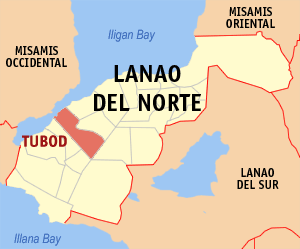
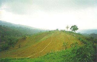
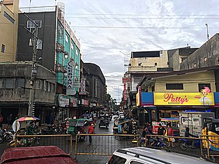
Tubod, officially the Municipality of Tubod,, is a 1st class municipality and capital of the province of Lanao del Norte, Philippines. According to the 2020 census, it has a population of 60,182 people.

<span class="mw-page-title-main">Alubijid</span> Municipality in Misamis Oriental, Philippines

Alubijid, officially the Municipality of Alubijid, is a 4th class municipality in the province of Misamis Oriental, Philippines. According to the 2020 census, it has a population of 32,163 people.

<span class="mw-page-title-main">El Salvador, Misamis Oriental</span> Component city in Misamis Oriental, Philippines

El Salvador, officially the City of El Salvador, is a 6th class component city in the province of Misamis Oriental, Philippines. According to the 2020 census, it has a population of 58,771 people.

<span class="mw-page-title-main">José Ozámiz</span> José Ozámiz: first governor of Misamis Occidental, WWII hero

José Ozámiz y Fortich was a Spanish Filipino lawyer and politician from Misamis Occidental.

References

  1. Municipality of Tudela | (DILG)
  2. "2015 Census of Population, Report No. 3 – Population, Land Area, and Population Density" (PDF). Philippine Statistics Authority. Quezon City, Philippines. August 2016. ISSN   0117-1453. Archived (PDF) from the original on May 25, 2021. Retrieved July 16, 2021.
  3. 1 2 3 Census of Population (2020). "Region X (Northern Mindanao)". Total Population by Province, City, Municipality and Barangay. Philippine Statistics Authority . Retrieved 8 July 2021.
  4. "PSA Releases the 2018 Municipal and City Level Poverty Estimates". Philippine Statistics Authority. 15 December 2021. Retrieved 22 January 2022.
  5. Binalbal Festival Archived 2005-01-25 at the Wayback Machine
  6. 1 2 Tudela Binalbal Festival Official Souvenir, published January 1, 2003, (Local Government Unit of Tudela, Misamis Occidental); Panfilo S. Olarte, Secretary to the Sanggunian 1988-2003
  7. Naval, Lhem (2017). "Grand Old Northwest Foundation and Development of Towns and parishes in Misamis Occidental". Misamis Occidental: Historical Vignettes of Grand Northwest (2nd ed.). Baliangao, Misamis Occidental, Philippines: Synoptika Publishers. ISBN   9781365724350.
  8. Naval, Lhem (2017). "Who is Apolinario Tudela? The Historical Beginnings of Tudela". Misamis Occidental: Historical Vignettes of Grand Northwest (2nd ed.). Baliangao, Misamis Occidental, Philippines: Synoptika Publishers. ISBN   9781365724350.
  9. 1 2 Executive orders and proclamations (1920). Manila: Bureau of Printing. 1921. pp. 98–100. Retrieved March 11, 2024 via Internet Archive.
  10. Act No. 951:
  11. "Index to Official Gazette (1913–1928)" (PDF). University of San Carlos. 2011–2012. Retrieved July 31, 2022 via The Library Corporation.
  12. "Batas Pambansa Blg. 171". The Corpus Juris. The Corpus Juris. February 8, 1982. Retrieved January 17, 2019.
  13. "Republic Act No. 6845". Chan Robles Virtual Law Library. Chan Robles and Associates Law Firm. January 20, 1990. Retrieved January 17, 2019.
  14. Doyo, Ma. Ceres P. "Martial law massacres" . Retrieved 2018-06-18.
  15. Report of an Amnesty International Mission to the Republic of the Philippines, 11 – 28 Nov 1981 (PDF) (Report). Amnesty International. November 28, 1981.
  16. "Tudela: Average Temperatures and Rainfall". Meteoblue. Retrieved 29 April 2020.
  17. Census of Population (2015). "Region X (Northern Mindanao)". Total Population by Province, City, Municipality and Barangay. Philippine Statistics Authority . Retrieved 20 June 2016.
  18. Census of Population and Housing (2010). "Region X (Northern Mindanao)" (PDF). Total Population by Province, City, Municipality and Barangay. National Statistics Office . Retrieved 29 June 2016.
  19. Censuses of Population (1903–2007). "Region X (Northern Mindanao)". Table 1. Population Enumerated in Various Censuses by Province/Highly Urbanized City: 1903 to 2007. National Statistics Office.{{cite encyclopedia}}: CS1 maint: numeric names: authors list (link)
  20. "Province of Misamis Occidental". Municipality Population Data. Local Water Utilities Administration Research Division. Retrieved 17 December 2016.
  21. "Poverty incidence (PI):". Philippine Statistics Authority. Retrieved December 28, 2020.
  22. "Estimation of Local Poverty in the Philippines" (PDF). Philippine Statistics Authority. 29 November 2005.
  23. "2003 City and Municipal Level Poverty Estimates" (PDF). Philippine Statistics Authority. 23 March 2009.
  24. "City and Municipal Level Poverty Estimates; 2006 and 2009" (PDF). Philippine Statistics Authority. 3 August 2012.
  25. "2012 Municipal and City Level Poverty Estimates" (PDF). Philippine Statistics Authority. 31 May 2016.
  26. "Municipal and City Level Small Area Poverty Estimates; 2009, 2012 and 2015". Philippine Statistics Authority. 10 July 2019.
  27. "PSA Releases the 2018 Municipal and City Level Poverty Estimates". Philippine Statistics Authority. 15 December 2021. Retrieved 22 January 2022.
  28. "PSA Releases the 2021 City and Municipal Level Poverty Estimates". Philippine Statistics Authority. 2 April 2024. Retrieved 28 April 2024.
  29. "Smart completes Sun rebrand". smart.com.ph. Retrieved 2022-04-21.
  30. "Out Line of Service Area - Metro Ozamiz Water District" . Retrieved 2019-01-17.