Papeete is the capital city of French Polynesia, an overseas collectivity of the French Republic in the Pacific Ocean. The commune of Papeete is located on the island of Tahiti, in the administrative subdivision of the Windward Islands, of which Papeete is the administrative capital. Both the President of French Polynesia and French High Commissioner reside in Papeete.

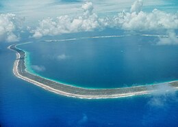
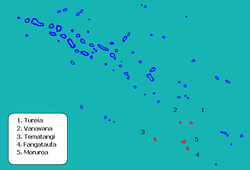
Moruroa, also historically known as Aopuni, is an atoll which forms part of the Tuamotu Archipelago in French Polynesia in the southern Pacific Ocean. It is located about 1,250 kilometres (780 mi) southeast of Tahiti. Administratively Moruroa Atoll is part of the commune of Tureia, which includes the atolls of Tureia, Fangataufa, Tematangi and Vanavana. France undertook nuclear weapon tests between 1966 and 1996 at Moruroa and Fangataufa, causing international protests, notably in 1974 and 1995. The number of tests performed on Moruroa has been variously reported as 175 and 181.

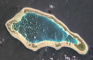
Fangataufa is an uninhabited coral atoll in the eastern part of the Tuamotu Archipelago in French Polynesia. The atoll has been fully-owned by the French state since 1964. From 1966 to 1996 it was used as a nuclear test site by the French government. In total, 4 atmospheric and 10 underground nuclear explosions were carried out on the atoll.

Puka-Puka is a small inhabited coral atoll in the north-eastern Tuamotu Archipelago, sometimes included as a member of the Disappointment Islands. This atoll is quite isolated, the nearest land being Fakahina, 182 km to the southwest.
Napuka, or Pukaroa, is a small coral atoll in the Disappointment Islands, in the northeastern part of the Tuamotu Archipelago in French Polynesia. It is located only 15 km to the southeast of Tepoto Nord, its nearest neighbor, forming a small group. These two atolls are quite isolated, the nearest land being Fangatau Atoll 170 km to the south.
Rūrutu is the northernmost island in the Austral archipelago of French Polynesia, and the name of a commune consisting solely of that island. It is situated 572 km (355 mi) south of Tahiti. Its land area is 32.7 km2 (12.6 sq mi). It is 10.8 km long and 5.3 km wide. Its highest point (Manureva) is 389 m (1,276 ft). At the 2022 census it had a population of 2,163.

Arue is a commune in the suburbs of Papeete in French Polynesia, an overseas territory of France in the Pacific Ocean. Arue is located on the island of Tahiti, in the administrative subdivision of the Windward Islands, themselves part of the Society Islands. At the 2022 census it had a population of 10,322.
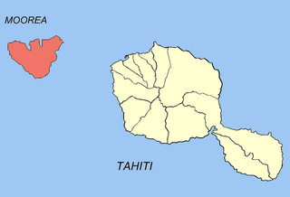
Moorea-Maiao is a commune of French Polynesia, an overseas territory of France in the Pacific Ocean. It consists of the island of Mo'orea and the much smaller atoll of Maiao, located 78 km (48 mi) southwest of Mo'orea, with both being part of the Windward Islands administrative subdivision. As of the 2022 census, Moorea-Maiao had a population of 18,201, of whom 17,858 lived on Mo'orea and 343 lived on Maiao.

Nukutavake or Nukutuvake is an island in the Tuamotu group in French Polynesia. It lies 1125 km from Tahiti. The closest land is small Pinaki Atoll, located 15 km to the southeast. Vairaatea Atoll lies 38 km to the west of Nukutavake.

Tematagi or Tematangi is an atoll in the southeastern area of the Tuamotu Archipelago, French Polynesia. Tematagi's nearest neighbour is Mururoa, which is located 161 kilometres to the ESE.

Arutua, or Ngaru-atua is an atoll in the Tuamotu group in French Polynesia. It is located 40 km SW of Rangiroa. The closest land is Apataki Atoll, only 16 km to the East.
Fangatau, or Nakai-erua, is a small atoll in the Tuamotu group in French Polynesia. The nearest land is Fakahina Atoll, located 72 km to the ESE. This small atoll has an elongated shape. Its length is 8 kilometres, maximum width 3.5 kilometres. It has a total area of 22.2 square kilometres, land area 5.9 km2. Its reef encloses its lagoon completely. Anchorage is difficult. Fangatau Atoll has 150 inhabitants. Teana is the main village.

Reao or Natūpe is an atoll in the eastern expanses of the Tuamotu group in French Polynesia. The closest land is Pukarua Atoll, located 48 km to the WNW.
Takaroa, Taka-roa or Takapua, is an atoll in the Tuamotu group in French Polynesia. It has a length of 27.4 kilometres and a width of 7 km (4 mi); its land area is 20 square kilometres.

Tatakoto is an atoll in the Tuamotu group in French Polynesia.
Faaite, or Faaiti is an atoll of the Tuamotus in French Polynesia. It is located 60 kilometres to the north of Anaa Atoll. The total surface of the atoll is 227 square kilometres Its dry land area is 8.87 square kilometres. Its length is 28 kilometres and its width 10.5 kilometres. The total population as of 2022 is 440 inhabitants.

Vanavana, Kurataki, or Huataki is an atoll in the southeastern area of the Tuamotu Archipelago, French Polynesia. Vanavana's nearest neighbour is Tureia, which is located 58 kilometres to the east.

Rangiroa is a commune of French Polynesia in the archipelago of the Tuamotu Islands. The commune includes four islands: Rangiroa, Tikehau, Mataiva and Makatea. The chef-lieu is the village Tiputa.
Fakarava is a commune of French Polynesia in the archipelago of the Tuamotu Islands. The commune is in the administrative subdivision of the Îles Tuamotu-Gambier. The commune includes seven islands. The chef-lieu is the village Rotoava.

Gambier is a commune of French Polynesia in the administrative subdivision of the Tuamotu-Gambier Islands. The commune includes the Gambier Islands as well as several atolls in the Tuamotu Archipelago. All the Tuamotu atolls belonging to the commune are uninhabited except for Marutea Sud, and are sometimes mistakenly included among the Gambier Islands themselves. The commune population was 1,570 at the 2022 census. Its total land area is 45.97 km2.