Turner, Kansas

Last updated

Turner, Kansas
Neighborhood
USA Kansas location map.svg
Red pog.svg
Turner
Location within the state of Kansas
Coordinates: 39°05′00″N94°42′16″W / 39.08333°N 94.70444°W / 39.08333; -94.70444 [1]
Country United States
State Kansas
County Wyandotte
Elevation
[1]
830 ft (253 m)
Time zone UTC-6 (CST)
  Summer (DST) UTC-5 (CDT)
Area code 913
FIPS code 20-71775 [1]
GNIS feature ID0478951 [1]

Turner is a neighborhood within Kansas City, Kansas, United States. [1] It was formerly an unincorporated community of Wyandotte County, similar to Piper, Kansas. Turner has its own school district, Turner USD #202.

Contents

History

The Prophet (Tenskwatawa; literally, "the door opener"), brother of Tecumseh, created Shawneetown in the area (near what today is Woodend and Shawnee Drive at 35th street). He made his final home near Turner in Argentine, Kansas (the property is today owned by Jack Beemont).[ citation needed ] Blue Jacket (Weyapiersenwah), who was Tecumseh's adoptive brother, was known to the early European settlers in this area. According to legend, one of the Shawnee chiefs, Fish, died and was buried in the Shawnee Township Cemetery (which is located in the heart of modern-day Turner).[ citation needed ]

19th century

Wyandotte County, Kansas, 1899 Map from History of Kansas by Noble Prentis. Wy1899.gif
Wyandotte County, Kansas, 1899 Map from History of Kansas by Noble Prentis.

In 1828, Cyprian Chouteau established the first trading post in this locale. It was the American Fur Company trading house (located near 55th and Speaker Road). The original Shawnee Methodist Mission was built in 1830 near Chouteau's old trading post (near the heart of the Turner community). Reverend Thomas Johnson built the mission for the Shawnee. It was located at what would be 5100 block of Edgehill Drive. This mission was open until 1839, when the Mission School was built at the current location in Johnson County. Around 1837, Charles Lovelace established a saw mill (today it would be located at 55th and Speaker Road, but has been long ago torn down). There was also a grist mill in close proximity. In 1838, the mighty steamboat, "The Antelope" docked in the area. It had several scientists and pioneers heading west. They stayed over in the area on their journey to Fort Pierre in South Dakota. [2]

The Delaware Crossing (or "Military Crossing"; sometimes "the Secondine ") was where the old Indian trail met the waters of the Kaw River. Around 1831, Moses Grinter (one of the earliest permanent white settler in the area) set up the Grinter Ferry on the Kansas River here. His house, the Grinter Place, still stands at 1420 South 78th Street. The ferry was used by individuals (such as traders, freighters, and soldiers) traveling between Fort Leavenworth and Fort Scott on the military road. Other would cross this area on their way to Santa Fe. [2]

Various farmers took up residence around Turner by the fall of 1854. Turner as a community was known as early as 1856 (and no later than 1859). The community, then named "Farmer, Kansas", tried to incorporate itself on October 8, 1859. The attempt failed because the community never had enough population to achieve the statute requirements. [2]

Members of the old Quantrill's Raiders sacked a few homes and killed some of the inhabitants of the area around July 1863. Various families (living in the area that today is between Swartz Road from 51st to 53rd Street) suffered in the attacks. They were fended off from but a few homes. [2]

In 1859, the community had been referred to as the "Farmer" community (when the first post office was established). Twenty years later, the community took the name "Turner". Farmer post office name was switched to the "Turner" post office on September 23, 1879; by Robert M. Hester. [2] [3] [4]

20th century

The Flood of 1903 hit Turner. The 1910 population was around 200 people. In 1912, Turner had a few general stores, a school, money order post office, telegraph and express facilities. [2]

Historically, the Atchison, Topeka and Santa Fe Railway went through Argentine, Turner, and Kaw Valley. From the railroad yard in the Argentine, the railroad cars would be turned around at the Farmer train platform. The Farmer train station's circular platform stood at 55th street (which is Turner’s main downtown area). [2]

Parts of Turner were hit in the Great Flood of 1951 and the flood resulted in the "Highland" community being built (for displaced individuals from Argentine and Armourdale). Between late 1965 and early 1966, Kansas City, Kansas, annexed the community of Turner. Although now a part of Kansas City, Kansas, the community still retains its own distinct flavor and personality. [2]

The Turner post office was discontinued in 1958. [5]

Education

Primary and secondary education

Turner High School, in 2007 TurnerHigh2007.png
Turner High School, in 2007

The community is served by Turner USD 202 public school district.

The Golden Bear mascot was adopted for the school and community in 1886. Two members of the community, Warren Hewitt and Jule Gaignet, submitted the icon and it won the majority of support in a contest. Reportedly, the two youths had heard of the bear from stories told by their grandparents. This icon is based on legends of a golden bear that live in the area. [2]

According to John Gardiner in 1831, the great golden bear that lived in the area was feared and admired by the local native population. The bear lived south of the river in the hills west of the Methodist Mission. According to legend, it was the largest bear that any of the natives had ever seen. It would raid the settlements of the area folks and feasted on the animals owned by the local population (the Shawnee tribe). Many of the Indians wanted to kill the bear for the pride of such a feat and the capture of its hide (the fur was most sought after). The golden bear was seen several times by the ferry crew on the Old Grinter Ferry during the 1830s and 1840s. Both the Shawnee and the Wyandot gathered a hunting party, but were unsuccessful in tracking the bear down. [2]

Turner USD 202 consolidated the five old school districts of Turner, Junction, Oak Grove, Morris, and Muncie in 1961 and currently consists of:

  • Turner High School
  • Turner Middle School
  • Turner Primary
  • Junction Primary
  • Oak Grove Primary
  • Midland Trail Primary
  • Sixth Grade Academy

Infrastructure

Roads

Street names

The road overseers were Peter Partonnar, John Gibbs, and H. L. Swinggley. Peter Partonnar (sometimes misspelled as Parturner) has been rumored to be the origin of the name for Turner (but this is doubtful as the Partonnar family lived in Shawnee for many years and did not come to live in Turner till the name was already acquired). [2]

New and old
  • 55th Street (Portion) was known as "Lovelace Mill Road" and later it was named "Ambrose Key Road" after the saw mill was closed down. Still later it was renamed "Turner Avenue" until annexation. (55th leads Douglas and then into Key lane which goes to Gibbs Road)
  • 56th Street was "Central Avenue"
  • 57th Street was "Ore Avenue"
  • Gibbs Road was named in honor of John Gibbs Jr.
  • Metropolitan Avenue was "Hester Road" ; Albert Hester had a farm, Hester Farm, on this route (it also crossed the road from Fort Scott and Fort Leavenworth).
  • Swartz Road was "Silver Avenue"
  • Miami was "Smelter Avenue"
  • Osage was "Cable Avenue"
  • Key Lane was for a time called "Ridgeview Road"

Further reading

Related Research Articles

<span class="mw-page-title-main">Wyandotte, Michigan</span> City in Michigan, United States

Wyandotte is a city in Wayne County in the U.S. state of Michigan. The population was 25,058 at the 2020 census.

<span class="mw-page-title-main">Wyandotte County, Kansas</span> County in Kansas, United States

Wyandotte County is a county in the U.S. state of Kansas. Its county seat and most populous city is Kansas City, with which it shares a unified government. As of the 2020 census, the population was 169,245, making it Kansas's fourth-most populous county. The county was named after the Wyandot tribe.

<span class="mw-page-title-main">Miami County, Kansas</span> County in Kansas, United States

Miami County is a county located in east-central Kansas and is part of the Kansas City metropolitan area. Its county seat and most populous city is Paola. As of the 2020 census, the county population was 34,191. The county was named for the Miami tribe.

<span class="mw-page-title-main">Johnson County, Kansas</span> County in Kansas, United States

Johnson County is a county in the U.S. state of Kansas, along the border of the state of Missouri. Its county seat is Olathe. As of the 2020 census, the population was 609,863, the most populous county in Kansas. The county was named after Thomas Johnson, a Methodist missionary who was one of the state's first settlers. Largely suburban, the county contains a number of suburbs of Kansas City, Missouri, including Overland Park, a principal city of and second most populous city in the Kansas City Metropolitan Area.

<span class="mw-page-title-main">Shawnee, Kansas</span> City in Kansas, United States

Shawnee is a city in Johnson County, Kansas, United States. It is the seventh most populous municipality in the Kansas City metropolitan area. As of the 2020 census, the population of the city was 67,311.

<span class="mw-page-title-main">Kansas City, Kansas</span> Consolidated city-county in Kansas, United States

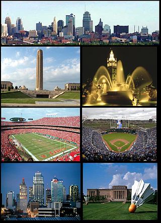
Kansas City is the third-most populous city in the U.S. state of Kansas, and the county seat of Wyandotte County. It is an inner suburb of the older and more populous Kansas City, Missouri, after which it is named. As of the 2020 census, the population of the city was 156,607, making it one of four principal cities in the Kansas City metropolitan area. It is situated at Kaw Point, the junction of the Missouri and Kansas rivers. It is part of a consolidated city-county government known as the "Unified Government". It is the location of the University of Kansas Medical Center and Kansas City Kansas Community College.

In American folklore, the Golden Bear was a large golden Ursus arctos. Members of the Ursus arctos species can reach masses of 130–700 kilograms (290–1,540 lb). The grizzly bear and the Kodiak bear are North American subspecies of the brown bear.

<span class="mw-page-title-main">U.S. Route 40</span> Highway in the United States

U.S. Route 40 or U.S. Highway 40 (US 40), also known as the Main Street of America, is a major east–west United States Highway traveling across the United States from the Mountain States to the Mid-Atlantic States. As with most routes whose numbers end in a zero, US 40 once traversed the entire United States. It is one of the first U.S. Highways created in 1926 and its original termini were in San Francisco, California, and Atlantic City, New Jersey. US 40 currently ends at a junction with I-80 in Silver Summit, Utah, just outside Salt Lake City. West of this point US 40 was functionally replaced with I-80, and as these segments of I-80 were constructed the western portion of US 40 was truncated several times.

<span class="mw-page-title-main">Kansas City metropolitan area</span> Metropolitan statistical area in the United States

The Kansas City metropolitan area is a bi-state metropolitan area containing Kansas City, Missouri. Its 14 counties straddle the border between the U.S. states of Missouri and Kansas having its core in both states.. With 8,472 square miles (21,940 km2) and a population of more than 2.2 million people, it is the second-largest metropolitan area with its 1950s dominant historic core city in Missouri and is the largest metropolitan area in Kansas, though Wichita is the largest metropolitan area with its 1950s dominant historic core city in Kansas. Alongside Kansas City, Missouri, these are the suburbs with populations above 100,000: Overland Park, Kansas; Kansas City, Kansas; Olathe, Kansas; Independence, Missouri; and Lee's Summit, Missouri.

<span class="mw-page-title-main">Wyandotte Nation</span> Federally recognized Native American tribe in Oklahoma

The Wyandotte Nation is a federally recognized Native American tribe headquartered in northeastern Oklahoma. They are descendants of the Wendat Confederacy and Native Americans with territory near Georgian Bay and Lake Huron. Under pressure from Haudenosaunee and other tribes, then from European settlers and the United States government, the tribe gradually moved south and west to Michigan, Ohio, Kansas, and finally Oklahoma in the United States.

<span class="mw-page-title-main">Argentine, Kansas</span>

Argentine is a community of Kansas City, Kansas, located in the southern part of Wyandotte County. It is bordered on the west by the Turner community, on the east by the Rosedale community, on the south by Johnson County, and on the north by Armourdale community and by the Kansas River.

<span class="mw-page-title-main">Interstate 635 (Kansas–Missouri)</span> Highway in Kansas and Missouri

Interstate 635 (I-635) is a connector highway between I-35 in Overland Park, Kansas, and I-29 in Kansas City, Missouri, approximately 12 miles (19 km) long. It is mostly in the US state of Kansas, servicing the city of Kansas City, Kansas, but extends into Kansas City, Missouri, as well. The freeway's southern terminus is at a stack interchange with I-35. South of this, the mainline becomes an expressway carrying U.S. Route 69 (US 69).

Monticello Township is a former township in northwest Johnson County, Kansas. It is now merged with Lenexa and Shawnee, Kansas.

<span class="mw-page-title-main">Shawnee Methodist Mission</span> United States historic place

Shawnee Methodist Mission, also known as the Shawnee Mission, which later became the Shawnee Indian Manual Labor School, is located in Fairway, Kansas, United States. Designated as a National Historic Landmark in 1968, the Shawnee Methodist Mission is operated by the city as a museum. The site is owned by the Kansas Historical Society and administered as the Shawnee Indian Mission State Historic Site.

<span class="mw-page-title-main">Grinter Place</span> Historic house in Kansas, United States

Grinter Place is a house on the National Register of Historic Places above the Kansas River in the Muncie neighborhood of Kansas City, Kansas.

Ambrose W. Key was an American pioneer. He was born in Crawfordsville, Indiana, the son of George Key and his wife Rebecca Mintun. George, a native of Virginia, settled with his family in Ohio circa 1800. From there, he began a career as a trader, traveling various rivers while establishing his trade routes. In 1836, George spotted lands in Iowa which reminded him of his boyhood home in Virginia, staking a claim to what he dubbed "Virginia Grove" in Louisa County. George planted crops there in 1836 and 1837, and wintered with his family back in Montgomery County, Indiana. While raising his crops in 1838, George sent for his wife and family to come to Iowa. Rebecca hired 10 men to help her move her family of 10 children, including Ambrose, 300 miles (480 km) from Indiana to Iowa. They averaged 7 miles per day on their 45-day trek, employing three wagons and a carriage, while driving a collection of young horses, cattle, and nearly 100 head of sheep.

Armourdale community is a district in the lower part of the Kansas River valley in Kansas City, Kansas. It is a main district between the West Bottoms and the Rosedale, Kansas area. The Kansas River makes an oxbow curve around the entire district, which is home to Shawnee Park and Bill Clem Park.

<span class="mw-page-title-main">Charles Blue Jacket</span>

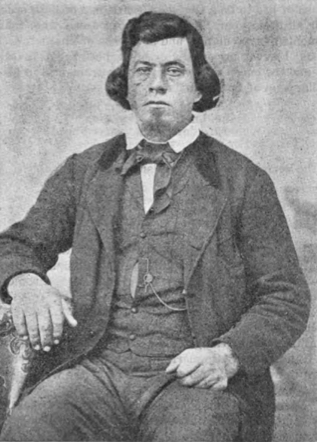
Charles Blue Jacket was a Shawnee chief in Kansas, as well as a Methodist minister. He was the grandson of the Shawnee Chief Blue Jacket by his son George Blue Jacket. Charles' mother is unknown, but is believed to have been a Shawnee. His maternal grandmother was the daughter of a Shawnee woman and Jacques Baby.

<span class="mw-page-title-main">Kansas City, Kansas Public Library</span>

Kansas City, Kansas Public Library (KCKPL) is the public library system of Kansas City, Kansas, headquartered in the Main Library. The library serves Wyandotte County, Kansas. It is governed by the Board of Education of Kansas City Kansas Public Schools and reports to the Wyandotte County Library Board

References

  1. 1 2 3 4 5 Geographic Names Information System (GNIS) details for Turner, Kansas; United States Geological Survey (USGS); October 13, 1978.
  2. 1 2 3 4 5 6 7 8 9 10 11 Betty S. Gibson, "Pride of the Golden Bear". Kendall Hunt Pub Co., June 1981. ISBN   0-8403-2397-2
  3. Jeanie Turner, states that her father was an engineer who laid out the roads of the newly formed town and it was named in his honor.
  4. Annotation: Farmer was a post office until September 23, 1879, when Robert M. Hester changed the name to Turner.
  5. "Kansas Post Offices, 1828-1961". Kansas Historical Society. Archived from the original on April 10, 2013. Retrieved June 29, 2014.{{cite web}}: CS1 maint: unfit URL (link)
  6. Wyandotte County and Kansas City, Kansas - Historical and Biographical; Goodspeed Publishing Co; 932 pages; 1890.