Santa Fe Trail

Last updated
Santa Fe Trail
Map of Santa Fe Trail-NPS.jpg
Map of the Santa Fe Trail
Location Missouri, Kansas, Oklahoma, Texas, New Mexico, Colorado
Established1822
Governing body National Park Service
Website Santa Fe National Historic Trail

The Santa Fe Trail was a 19th-century route through central North America that connected Franklin, Missouri, with Santa Fe, New Mexico. Pioneered in 1821 by William Becknell, who departed from the Boonslick region along the Missouri River, the trail served as a vital commercial highway until 1880, when the railroad arrived in Santa Fe. Santa Fe was near the end of El Camino Real de Tierra Adentro which carried trade from Mexico City. The trail was later incorporated into parts of the National Old Trails Road and U.S. Route 66. [1] [2]

Contents

The route skirted the northern edge and crossed the north-western corner of Comancheria, the territory of the Comanche. Realizing the value, they demanded compensation for granting passage to the trail. American traders envisioned them as another market. Comanche raiding farther south in Mexico isolated New Mexico, making it more dependent on the American trade. They raided to gain a steady supply of horses to sell. By the 1840s, trail traffic through the Arkansas Valley was so numerous that bison herds were cut off from important seasonal grazing land. This habitat disruption, on top of overhunting, contributed to the collapse of the species. Comanche power declined in the region when they lost their most important game. [3]

In 1846, during the Mexican–American War, the United States Army used the Santa Fe Trail to invade New Mexico. [4]

After the U.S. acquisition of the Southwest that ended the war, the trail was integral to the U.S. opening the region to economic development and settlement. It played a vital role in the westward expansion of the U.S. into these new lands. The road route is commemorated today by the National Park Service as the Santa Fe National Historic Trail. A highway route that roughly follows the trail's path, through the entire length of Kansas, the southeast corner of Colorado and northern New Mexico, has been designated as the Santa Fe Trail National Scenic Byway.

History

Arrival of the caravan at Santa Fe, lithograph published c.1844 Arrival of the caravan at Santa Fe, c. 1844.jpg
Arrival of the caravan at Santa Fe, lithograph published c.1844
Former U.S. Army outpost on the Santa Fe Trail, now a rest area on I-25 in northern New Mexico Santa Fe Trail outpost.JPG
Former U.S. Army outpost on the Santa Fe Trail, now a rest area on I-25 in northern New Mexico

The Santa Fe Trail was a transportation route opened by the Indigenous people of North America as well as European trappers and traders in the second half of the 18th century. It was later used extensively by people from the United States in the 19th century after the Louisiana Purchase. Traders and settlers crossed the southwest of North America by the route connecting Independence, Missouri, with Santa Fe, New Mexico. Its major market in Missouri was St. Louis, with its port on the Mississippi River.

In 1719, the French officer Claude Charles Du Tisne was tasked by French authorities to establish a route to trade with the Spanish colony of Santa Fe in New Mexico. This first expedition, which started in Kaskaskia, Illinois, failed, as it was stopped by Indian tribes in Kansas. Then, at the time of the Louisiana regime, under French and then Spanish sovereignty, the French traders Pierre Antoine and Paul Mallet made a first trip in 1739 and 1740, starting also from Kaskaskia, Illinois, reaching Santa Fe and returning. They made other expeditions in 1741 and 1750, which faced various challenges from Indians and Spaniards. Then, the French explorer Pierre Vial made another pioneering trip on the route in 1792, and French traders and trappers from St. Louis gained progressively a fur trading dominance from the Spanish in Santa Fe as well as with the Indian tribes living in this vast region. Other French traders and trappers made trips on the trail from St. Louis, such as Auguste Pierre Chouteau and Jules de Mun in 1815, who were arrested by Spanish authorities in Santa Fe.

After Louisiana was sold to the United States in 1803 (Louisiana Purchase), Americans improved and publicized the Santa Fe Trail beginning in 1822, in order to take advantage of new trade opportunities with Mexico which had just won independence from Spain in the Mexican War of Independence. Manufactured goods were hauled from Missouri to Santa Fe, which was then in the northern Mexican state of Nuevo Mexico . [5]

Settlers seeking the opportunity to hold free land used wagon trains to follow various emigrant trails that branched off to points west. The political philosophy of manifest destiny, the idea that the U.S. should extend from one coast to another, dominated national political discussions. The trail connected interior port cities along the Mississippi and Missouri and their wagon train outfitters to western destinations. The trail was used to carry products from the central plains to the trail head towns St. Joseph and Independence, Missouri.

In the 1820s–1830s, it was also sporadically important in the reverse trade, used by traders to transport foods and supplies to the fur trappers and mountain men opening the remote Northwest, especially in the interior Northwest: Idaho, Wyoming, Colorado, and Montana. A mule trail (trapper's trails) led to points north to supply the lucrative overland fur trade in ports on the Pacific Coast.

North–South trade

Santa Fe was near the northern terminus of El Camino Real de Tierra Adentro, which led overland between Mexico City to San Juan Pueblo, New Mexico.

Cargo mule trains were run from Fort Bernard in Wyoming to the Santa Fe Trail at Fort Bent in Colorado .

Importance of Santa Fe

Map of the Republic of Texas showing lands claimed by Texas after 1836 and present-day outline of New Mexico on the boundaries of 1836-1845 Wpdms republic of texas.svg
Map of the Republic of Texas showing lands claimed by Texas after 1836 and present-day outline of New Mexico on the boundaries of 1836–1845

In 1825, the merchant Manuel Escudero of Chihuahua was commissioned by New Mexico governor Bartolome Baca to negotiate in Washington, D.C. for opening U.S. borders to traders from Mexico. Beginning in 1826, prominent aristocratic families of New Mexicans, such as the Chávezes, Armijos, Pereas, and Oteros, entered into the commerce along the trail. By 1843, traders from New Mexico and Chihuahua had become the majority of traders involved in the traffic of goods over the Santa Fe Trail. [6]

In 1835, Mexico City had sent Albino Pérez to govern the department of New Mexico as Jefe Politico (political chief or governor) and as commanding military officer. In 1837, the forces of Rio Arriba (the upper Rio Grande, i.e., northern New Mexico) rebelled against Pérez's enforcement of the recent Mexican constitution, new revenue laws taxing Santa Fe commerce and entertainment, and the large grants of New Mexico land to wealthy Mexicans. New Mexicans appreciated the relative freedoms of a frontier, remote from Mexico City. The rebels defeated and executed governor Albino Perez, but were later ousted by the forces of Rio Abajo (the lower Rio Grande, or southern New Mexico) led by Manuel Armijo. [7]

Conflict between Texas and Mexico

The Republic of Texas competed with Mexico in claiming Santa Fe, as part of the territory north and east of the Rio Grande which both nations claimed following Texas's secession from Mexico in 1836.

In 1841, a small military and trading expedition departed from Austin, Texas for Santa Fe. They represented the Republic of Texas and its president Mirabeau B. Lamar. Their intention was to persuade the people of Santa Fe and New Mexico to relinquish control over the territory under dispute with Mexico, and over associated Santa Fe Trail commerce. Knowing about recent political disturbances there, they hoped for a welcome by the rebellious faction in New Mexico. What was known as the Texan Santa Fe Expedition encountered many difficulties. The party was captured by governor Armijo's Mexican army under less than honest negotiations. They were subjected to harsh and austere treatment during a tortuous forced march to Mexico City, where they were tried, convicted and imprisoned for their insurgent activities. [8]

In 1842, Colonel William A. Christy wrote Sam Houston, president of Texas, requesting support for an overthrow scheme by Charles Warfield dependent on armed forces. He proposed deposing the governments in the Mexican provinces of New Mexico and Chihuahua and returning half of the spoils to the Republic of Texas. Houston agreed, provided the operation be conducted under the strictest secrecy.

He commissioned Warfield as a colonel, who attempted to raise volunteers in Texas, St. Louis, Missouri; and the southern Rockies for a Warfield Expedition. He recruited John McDaniel and a small band of men in the proximate vicinity of St. Louis, giving McDaniel the rank of a Texas captain. After Warfield headed toward the Rockies with a companion, McDaniel led a robbery in April 1843 (in present-day Rice County, Kansas) of a lightly defended Santa Fe Trail trading caravan. This resulted in the murder of its leader Antonio José Chávez, the son of a former governor of New Mexico, Francisco Xavier Chávez. [9] [10]

Warfield was reportedly unaware of the crime. McDaniel and one accomplice were tried, convicted and executed. Other participating suspects arrested by the U.S. were convicted and imprisoned. The newspapers reported that Americans and Mexicans were outraged by the crime. Local merchants and citizens at the U.S. end of the Santa Fe Trail demanded justice and a return to the stable commerce which their economy depended on. [6]

After the murder of Chávez, Warfield began limited military hostilities in the region using recruits from the southern Rockies. He made an unprovoked attack on Mexican troops outside Mora, New Mexico, leaving five dead. Warfield lost his horses after an encounter in Wagon Mound, where the Mexican forces had made chase. After Warfield's men reached Bent's Fort on foot, they disbanded.

In February 1843, Colonel Jacob Snively had received a commission to intercept Mexican caravans along the Santa Fe Trail, similar to that received by Warfield the year prior. After disbanding the volunteers under his command, Warfield located and joined the 190-man, Texas "Battalion of Invincibles," under the command of Snively. New Mexico Governor Manuel Armijo led Mexican troops out of Santa Fe to protect incoming caravans. But, after the Invincibles destroyed much of an advance party led by Captain Ventura Lovato, the governor retreated. Following this battle, many Americans resigned and Snively's force was reduced to little over 100 men. [6] Snively planned to plunder Mexican merchant caravans on territory claimed by Texas, in retaliation for recent Texian executions and Mexican invasions, but his battalion was quickly arrested and disarmed by the US troops escorting the caravans. [11] After disarming these men, Captain Philip St. George Cooke allowed them to return to Texas. [6]

Mother of the railroad

Connections along the Santa Fe Railroad, showing the principal regular stops on the AT&SF mainline, including cattle drive destinations such as Dodge City. It is no accident that most of those Kansas, Colorado, and New Mexican towns were also first serviced by the Santa Fe Trail. Grand Canyon Route of the Atchison, Topeka & Santa Fe Railway 1900-05.jpg
Connections along the Santa Fe Railroad, showing the principal regular stops on the AT&SF mainline, including cattle drive destinations such as Dodge City. It is no accident that most of those Kansas, Colorado, and New Mexican towns were also first serviced by the Santa Fe Trail.

In 1863, while railroad legislation underwent continual revisions, entrepreneurs grew more interested in the American Southwest, leading to the construction of the Atchison, Topeka and Santa Fe Railway. As the name suggests, the intended eastern terminus was to be Atchison, Kansas.

In Kansas, the AT&SF roadbed roughly paralleled the Santa Fe Trail west of Topeka as it expanded between 1868 and 1874. When a railroad bridge was built across the Missouri River to connect eastern markets to the Dodge City cattle trail and Colorado coal mines, the railroad spurred the growth of Kansas City, Missouri. Building the railway westwards beyond the New Mexico border was delayed and placed the railroad under financial pressure. In response, they offered packaged "Shopping Excursion deals" to potential real estate buyers. The railroad began to discount such trips to visit its land offices and gave back the ticket price as part of the purchase price if a sale was concluded.

The railroad's sale of its land granted by congress fostered growth of new towns and businesses along its route, which generated railway traffic and revenues. With this financial base, the railway extended west, gradually adding new connections through rougher west country along the western Trail. With the development of rail transport, traffic on the Trail soon dropped to merely local trade. After World War I the trail was gradually became a paved automobile road.

Route

Santa Fe Trail highway sign in Cimarron, New Mexico Santa Fe Trail sign IMG 0516.JPG
Santa Fe Trail highway sign in Cimarron, New Mexico
End of the Santa Fe Trail marker on the Plaza in Santa Fe, New Mexico EndSantaFe 2011.jpg
End of the Santa Fe Trail marker on the Plaza in Santa Fe, New Mexico

The eastern end of the trail was in the central Missouri town of Franklin on the north bank of the Missouri River. [12] [13] [14] The route across Missouri first used by Becknell followed portions of the existing Osage Trace and the Medicine Trails. West of Franklin, the trail crossed the Missouri near Arrow Rock, after which it followed roughly the route of present-day U.S. Route 24. It passed north of Marshall, through Lexington to Fort Osage, then to Independence. Independence was also one of the historic "jumping off points" for the Oregon and California Trails.

West of Independence, it roughly followed the route of U.S. Route 56 from near the town of Olathe to the western border of Kansas. It enters Colorado, cutting across the southeast corner of the state before entering New Mexico. The section of the trail between Independence and Olathe was also used by immigrants on the California and Oregon Trails, which branched off to the northwest near Gardner, Kansas.

From Olathe, the trail passed through the towns of Baldwin City, Burlingame, and Council Grove, then swung west of McPherson to the town of Lyons. West of Lyons the trail followed nearly the route of present-day Highway 56 to Great Bend. Ruts in the earth made from the trail are still visible in several locations (Ralph's Ruts are visible in aerial photos at ( 38°21′35″N98°25′20″W / 38.35959264°N 98.42225502°W / 38.35959264; -98.42225502 ). [15] At Great Bend, the trail encountered the Arkansas River. Branches of the trail followed both sides of the river upstream to Dodge City and Garden City.

West of Garden City in southwestern Kansas the trail splits into two branches. One of the branches, called the Mountain Route or the Upper Crossing follows the Purgatoire River from La Junta upstream to Trinidad then south through the Raton Pass into New Mexico. [12] :93 [16] :133

The other main branch, called the Cimarron Cutoff or Cimarron Crossing or Middle Crossing [12] :93 [16] :133 [17] :144 cut southwest across the Cimarron Desert (also known as the Waterscrape or La Jornada [17] :148) to the valley of the Cimarron River near the town of Ulysses and Elkhart then continued toward Boise City, Oklahoma, to Clayton, New Mexico, joining up with northern branch at Fort Union. This route was generally very hazardous because it had very little water. [18] In fact, the Cimarron River was one of the only sources of water along this branch of the trail.

From Watrous, the reunited branches continued southward to Santa Fe. [12] Part of this route has been designated a National Scenic Byway.

Challenges

Santa Fe Trail Ruts at Fort Union Santaferuts.JPG
Santa Fe Trail Ruts at Fort Union

Travelers faced many hardships along the Santa Fe Trail. The trail was a challenging 900 miles (1,400 km) of dangerous plains, hot deserts, and steep and rocky mountains. The natural weather was and is continental: very hot and dry summers, coupled with long and bitterly cold winters. Fresh water was scarce, and the high steppe-like plains are nearly treeless. Water flows in the Pecos, Arkansas, Cimarron, and Canadian rivers that drain the region vary by 90 or more percent in their flows during an average year. Also on this trail, unlike the Oregon Trail, there was a serious danger of Indian attacks, for neither the Comanche nor the Apache of the southern high plains tolerated trespassers. In 1825, Congress voted for federal protection for the Santa Fe Trail, even though much of it lay in the Mexican territory. Lack of food and water also made the trail very risky. Weather conditions, like huge lightning storms, gave the travelers even more difficulty. If a storm developed, there was often no place to take shelter and the livestock could get spooked. Rattlesnakes often posed a threat, and many people died due to snakebites. The caravan size increased later on to prevent Indian raids. The travelers also harnessed more oxen instead of mules—primarily for the greater hauling power of oxen but also because they were less valued by Indians and thus less risk of being raided.

Historic preservation

Segments of this trail in Missouri, Kansas, Oklahoma, and New Mexico are listed on the National Register of Historic Places. [19] In Missouri, this includes the 85th and Manchester "Three Trails" Trail Segment, Arrow Rock Ferry Landing, Santa Fe Trail – Grand Pass Trail Segments, and Santa Fe Trail – Saline County Trail Segments. The longest clearly identifiable section of the trail, Santa Fe Trail Remains, near Dodge City, Kansas, is listed as a National Historic Landmark. [20] In Colorado, Santa Fe Trail Mountain Route – Bent's New Fort is included on the National Register.

Notable features

Santa Fe Trail marker in Coolidge, Kansas Santa Fe Trail marker in Coolidge, KS IMG 5820.JPG
Santa Fe Trail marker in Coolidge, Kansas
Santa Fe Trail Ruts west of Larned, Kansas Santa Fe Trail Ruts (west of Ft Larned).jpg
Santa Fe Trail Ruts west of Larned, Kansas
Santa Fe Trail marker at the Cuerno Verde Rest Area, Colorado Santa Fe Trail Historical Marker.png
Santa Fe Trail marker at the Cuerno Verde Rest Area, Colorado
Missouri [21]
Kansas [21]

Mountain Route towards Colorado

Colorado [21]

Mountain Route

Cimarron Route thru Kansas towards Oklahoma

New Mexico [21]

Mountain Route

Cimarron Route

Joint route

See also

Related Research Articles

<span class="mw-page-title-main">Cimarron River (Arkansas River tributary)</span> River in the United States

The Cimarron River extends 698 miles (1,123 km) across New Mexico, Oklahoma, Colorado, and Kansas. The headwaters flow from Johnson Mesa west of Folsom in northeastern New Mexico. Much of the river's length lies in Oklahoma, where it either borders or passes through eleven counties. There are no major cities along its route. The river enters the Oklahoma Panhandle near Kenton, Oklahoma, crosses the corner of southeastern Colorado into Kansas, reenters the Oklahoma Panhandle, reenters Kansas, and finally returns to Oklahoma where it joins the Arkansas River at Keystone Reservoir west of Tulsa, Oklahoma, its only impoundment. The Cimarron drains a basin that encompasses about 18,927 square miles (49,020 km2).

<span class="mw-page-title-main">Ceran St. Vrain</span> French–American fur trader (1802–1870)

Ceran St. Vrain, born Ceran de Hault de Lassus de Saint-Vrain, was the son of a French aristocrat who emigrated to the Spanish Louisiana in the late 18th century; his mother was from St. Louis, where he was born. To gain the ability to trade, in 1831 he became a naturalized Mexican citizen in what is now the state of New Mexico. He formed a partnership with American traders William, George and Charles Bent; together they established the trading post of Bent's Fort. It was the only privately held fort in the West.

<span class="mw-page-title-main">William Bent</span> American rancher and frontier trader (1809–1869)

William Wells Bent was a frontier trader and rancher in the American West, with forts in Colorado. He also acted as a mediator among the Cheyenne Nation, other Native American tribes and the expanding United States. With his brothers, Bent established a trade business along the Santa Fe Trail. In the early 1830s Bent built an adobe fort, called Bent's Fort, along the Arkansas River in present-day Colorado. Furs, horses and other goods were traded for food and other household goods by travelers along the Santa Fe trail, fur-trappers, and local Mexican and Native American people. Bent negotiated a peace among the many Plains tribes north and south of the Arkansas River, as well as between the Native American and the United States government.

<span class="mw-page-title-main">Old Spanish Trail (trade route)</span> United States historic place

The Old Spanish Trail is a historical trade route that connected the northern New Mexico settlements of Santa Fe, New Mexico with those of Los Angeles, California and southern California. Approximately 700 mi (1,100 km) long, the trail ran through areas of high mountains, arid deserts, and deep canyons. It is considered one of the most arduous of all trade routes ever established in the United States. Explored, in part, by Spanish explorers as early as the late 16th century, the trail was extensively used by traders with pack trains from about 1830 until the mid-1850s. The area was part of Mexico from Mexican independence in 1821 to the Mexican Cession to the United States in 1848.

<span class="mw-page-title-main">Cimarron National Grassland</span> American national grassland in Kansas

Cimarron National Grassland is a National Grassland located in Morton County, Kansas, United States, with a very small part extending eastward into Stevens County. Cimarron National Grassland is located near Comanche National Grassland which is across the border in Colorado. The grassland is administered by the Forest Service together with the Pike and San Isabel National Forests and the Comanche National Grassland, from common headquarters located in Pueblo, Colorado. There are local ranger district offices in Elkhart, Kansas. The grassland is the largest area of public land in the state of Kansas.

<span class="mw-page-title-main">Comanche history</span> History of Native American tribe

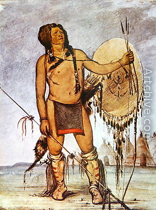
Comanche history In the 18th and 19th centuries the Comanche became the dominant tribe on the southern Great Plains. The Comanche are often characterized as "Lords of the Plains." They presided over a large area called Comancheria which they shared with allied tribes, the Kiowa, Kiowa-Apache, Wichita, and after 1840 the southern Cheyenne and Arapaho. Comanche power and their substantial wealth depended on horses, trading, and raiding. Adroit diplomacy was also a factor in maintaining their dominance and fending off enemies for more than a century. They subsisted on the bison herds of the Plains which they hunted for food and skins.

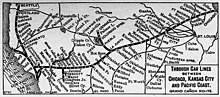
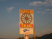
William Becknell was an American soldier, politician, and freight operator who is credited by Americans with opening the Santa Fe Trail in 1821. He found a trail for part of the route that was wide enough for wagon trains and draft teams, making it easier for trader and emigrants along this route. The Santa Fe Trail became an early major transportation route through central North America that connected Franklin, Missouri with Santa Fe, New Mexico, serving both trading and emigrant parties. It served as a vital commercial highway from the 1820s until 1880, when the railroad was introduced to Santa Fe. Becknell made use of long-established trails made by Native Americans, and Spanish and French colonial explorers and traders for centuries before his trip.

<span class="mw-page-title-main">Camino Real de Tierra Adentro</span> Northernmost of Mexico Citys four "royal roads"

The Camino Real de Tierra Adentro, also known as the Silver Route, was a Spanish 2,560-kilometre-long (1,590 mi) road between Mexico City and San Juan Pueblo, New Mexico, that was used from 1598 to 1882. It was the northernmost of the four major "royal roads" that linked Mexico City to its major tributaries during and after the Spanish colonial era.

<span class="mw-page-title-main">Santa Fe Trail Remains</span> United States historic place

The Santa Fe Trail Remains, also known as Santa Fe Trail Ruts, are a two-mile (3 km) section of the former 1,200-mile (1,900 km) long Santa Fe Trail, described as the "longest continuous stretch of clearly defined Santa Fe Trail rut remains in Kansas." Now owned by a preservation organization, the site is visible from a pull-off area on United States Route 50 near Dodge City, Kansas. The site was declared a National Historic Landmark in 1963.

<span class="mw-page-title-main">Rabbit Ears (Clayton, New Mexico)</span> United States historic place

The Rabbit Ears are a pair of mountain peaks in northeastern New Mexico, United States, 8 kilometres (5.0 mi) north of the city of Clayton. The two peaks were a distinctive landmark along the Cimarron Cutoff of the Santa Fe Trail, a major route for westbound settlers in the 19th century. The formation was designated a National Historic Landmark in 1963. The name is that of a Native American chief who was killed here in a battle with the Spanish in 1717.

In the history of the American frontier, pioneers built overland trails throughout the 19th century, especially between 1829 and 1870, as an alternative to sea and railroad transport. These immigrants began to settle much of North America west of the Great Plains as part of the mass overland migrations of the mid-19th century. Settlers emigrating from the eastern United States did so with various motives, among them religious persecution and economic incentives, to move from their homes to destinations further west via routes such as the Oregon, California, and Mormon Trails. After the end of the Mexican–American War in 1849, vast new American conquests again encouraged mass immigration. Legislation like the Donation Land Claim Act and significant events like the California Gold Rush further encouraged settlers to travel overland to the west.

<span class="mw-page-title-main">Great Osage Trail</span> Native American trail

The Great Osage Trail, also known as the Osage Trace or the Kaw Trace, was one of the more well-known Native American trails through the countryside of what are today called the Midwest and Plains States of the U.S., pathways originally created by herds of buffalo or other migrating wildlife.

<span class="mw-page-title-main">Owl Woman</span> Cheyenne woman (d. 1847)

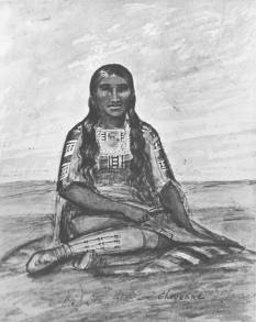
Owl Woman was a Cheyenne woman., a daughter of White Thunder, a well-respected medicine man of the Cheyenne tribe. She was married to an Anglo-American trader named William Bent, with whom she had four children. Owl Woman was inducted into the Colorado Women's Hall of Fame for her role in managing relations between Native American tribes and the Anglo-American men.

<span class="mw-page-title-main">Early history of the Arkansas Valley in Colorado</span> 17th to 19th century history of the valley

The early history of the Arkansas Valley in Colorado began in the 1600s and to the early 1800s when explorers, hunters, trappers, and traders of European descent came to the region. Prior to that, Colorado was home to prehistoric people, including Paleo-Indians, Ancestral Puebloans, and Late prehistoric Native Americans.

<span class="mw-page-title-main">Comanche Trail</span> Comanche travel route in Texas

The Comanche Trail, sometimes called the Comanche War Trail or the Comanche Trace, was a travel route in Texas established by the nomadic Comanche and their Kiowa and Kiowa Apache allies. Although called a "trail," the Comanche Trail was actually a network of parallel and branching trails, always running from one source of good water to another. The trail was especially important from the 1830s to 1850s when the Comanche launched large scale raids from Texas into Mexico. Hundreds of warriors annually followed the trail southward in fall and returned with their booty, mostly livestock, in late winter or spring.

Pierre Antoine and Paul Mallet, brothers and French Canadian voyageurs, were the first Europeans known to have crossed the Great Plains from east to west. They first journeyed to Santa Fe, New Mexico from Kaskaskia, Illinois in 1739.

Grant County is a county located in southwest Kansas, in the Central United States. Its county seat and only city is Ulysses.

François Xavier Aubry was a French Canadian merchant and explorer of the American Southwest. His achievements include speed records riding the Santa Fe Trail and early exploration of the 35th parallel north west of the North American continental divide.

Pedro Vial, or Pierre Vial, was a French explorer and frontiersman who lived among the Comanche and Wichita Indians for many years. He later worked for the Spanish government as a peacemaker, guide, and interpreter. He blazed trails across the Great Plains to connect the Spanish and French settlements in Texas, New Mexico, Missouri, and Louisiana. He led three Spanish expeditions that attempted unsuccessfully to intercept and halt the Lewis and Clark Expedition.

<span class="mw-page-title-main">Texan raids on New Mexico (1843)</span>

Texas raids on New Mexico in 1843 consisted of two expeditions sanctioned by the still independent country of Texas to raid Mexican commerce on the Santa Fe Trail and to assert control for Texas of New Mexico east of the Rio Grande, long inhabited by Hispanic settlers and Pueblo Indians. Both expeditions failed to do more than create apprehension by both the United States and Mexico that trade would be interrupted on the Santa Fe Trail. The Texans killed several Mexican traders along the trail and several civilians in a raid near the town of Mora, New Mexico. The Texans also killed or briefly took captive several Mexican soldiers.

References

  1. "The Quest for a National Road - The National Old Trails Road". Federal Highway Administration. December 19, 1911. Retrieved November 24, 2022.
  2. "The Route of the 1926 National Old Trails Road". Society for American Baseball Research. Retrieved November 24, 2022.
  3. Hämäläinen, Pekka (2008). The Comanche Empire. Yale University Press. pp. 159–160. ISBN   978-0300126549.
  4. Magoffin, Susan Shelby; Lamar, Howard R (1982). Drumm, Stella Madeleine (ed.). Down the Santa Fe Trail and Into Mexico: The Diary of Susan Shelby Magoffin, 1846–1847 . Copyright 1926, 1962 by Yale University Press. Univ. of Nebraska Press. ISBN   978-0803281165.
  5. Peters, Arthur King (1996). Seven trails West . Abbeville Press. pp.  55. ISBN   978-1558597822.
  6. 1 2 3 4 Marc Simmons, Murder on the Santa Fe Trail: an International Incident, 1843, El Paso, Texas: The University of Texas El Paso (1987)
  7. Ray John de Aragon, Padre Martinez and Bishop Lamy, Pan American Publishing Company (1978)[ ISBN missing ][ page needed ]
  8. Kendall, George (1884). "Narrative of the Texan Santa Fé Expedition". en.wikiquote.org. Retrieved 2017-10-25.
  9. Hyslop, Stephen Garrison (2001). Bound for Santa Fe: The Road to New Mexico and the American Conquest, 1806–1848. University of Oklahoma Press. ISBN   978-0806133898.
  10. "Kansas: A Encyclopedia of State History". Archived from the original on November 17, 2005.
  11. "Republic of Texas | The Handbook of Texas Online| Texas State Historical Association (TSHA)". Tshaonline.org. Retrieved 2012-11-18.
  12. 1 2 3 4 Duffus, R. (1972). The Santa Fe Trail . Albuquerque: University of New Mexico Press. ISBN   978-0826302359.
  13. "A History of the Santa Fe Trail". santafetrail.org. Retrieved 31 March 2019.
  14. Switzler, William F. (1882). History of Boone County. St. Louis: Western Historical Company.
  15. "Aerial Photos Topo Maps of Santa Fe Trail Ruts and Sites". Archived from the original on 2023-02-06. Retrieved 2007-12-28.
  16. 1 2 Vestal, Stanley (1996). The Old Santa Fe Trail. Lincoln: University of Nebraska Press. ISBN   978-0803296152.
  17. 1 2 Stocking, Hobart (1971). The Road to Santa Fe. New York: Hastings House Publishers. ISBN   978-0803863149.
  18. Samuel Gance, Anton ou la trajectoire d'un père, L'Harmattan, Paris, 2013. p. 115.[ ISBN missing ]
  19. Gallagher, Joseph J., Alice Edwards, Lachlan F. Blair, and Hugh Davidson (March 8, 1993). "National Register of Historic Places Multiple Property Nomination Form: Historic Resources of the Santa Fe Trail, 1821–1880" (PDF). Retrieved 2007-04-10.{{cite web}}: CS1 maint: multiple names: authors list (link)
  20. "National Historic Landmarks Program (NHL): Santa Fe Trail Remains". Archived from the original on May 1, 2015. Retrieved 2007-04-10.
  21. 1 2 3 4 Santa Fe trail, Official Map and Guide; National Park Service; Harpers Ferry, West Virginia; 1997

Further reading

Maps