The Sabine River is a 360-mile (580 km) long river in the Southern U.S. states of Texas and Louisiana, From the 32nd parallel north and downstream, it serves as part of the boundary between the two states and empties into Sabine Lake, an estuary of the Gulf of Mexico.

Maverick County is a county located in the U.S. state of Texas. As of the 2020 census, its population was 57,887. Its county seat is Eagle Pass. The county was created in 1856 and organized in 1871. It is named for Samuel Maverick, cattleman and state legislator.

El Camino Real is a 600-mile (965-kilometer) commemorative route connecting the 21 Spanish missions in California, along with a number of sub-missions, four presidios, and three pueblos. Historically associated with the Calle Real which terminates in Mexico City, as the former capital of New Spain and the seat of royal power for Las Californias, its southern end in the modern U.S. state of California is at Mission San Diego de Alcalá and its northern terminus is at Mission San Francisco Solano.
El Camino Real may refer to:

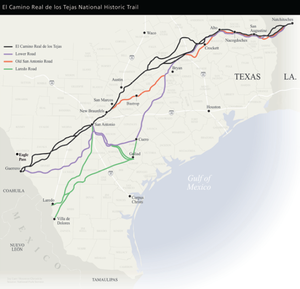
The Old San Antonio Road was a historic roadway located in the U.S. states of Texas and Louisiana. Parts of it were based on traditional Native American trails. Its Texas terminus was about 35 miles (56 km) southeast of Eagle Pass at the Rio Grande in Maverick County, and its northern terminus was at Natchitoches, Louisiana. The road continued from Texas through Monclova to Mexico City.

The Santa Fe Trail was a 19th-century route through central North America that connected Franklin, Missouri, with Santa Fe, New Mexico. Pioneered in 1821 by William Becknell, who departed from the Boonslick region along the Missouri River, the trail served as a vital commercial highway until 1880, when the railroad arrived in Santa Fe. Santa Fe was near the end of El Camino Real de Tierra Adentro which carried trade from Mexico City. The trail was later incorporated into parts of the National Old Trails Road and U.S. Route 66.
There are many historic trails and roads in the United States which were important to the settlement and development of the United States including those used by American Indians.

Los Adaes was the capital of Tejas on the northeastern frontier of New Spain from 1721 to 1773. It included a Franciscan mission, San Miguel de Cuellar de los Adaes, and a presidio, Nuestra Señora del Pilar de Los Adaes. The name Adaes derives from the indigenous Adai people, members of the Caddoan confederacy of Indians who were the people the missionaries aimed to convert to Christianity. The presidio and mission were established to counter French influence in Louisiana territory and defend New Spain from possible invasion or encroachment by the French. In 1763 Louisiana came under the control of Spain and the Los Adaes outpost was no longer necessary for defense. In 1773 the Spanish closed the mission and presidio and forced the population to move to San Antonio.

The Camino Real de Tierra Adentro, also known as the Silver Route, was a Spanish 2,560-kilometre-long (1,590 mi) road between Mexico City and San Juan Pueblo, New Mexico, that was used from 1598 to 1882. It was the northernmost of the four major "royal roads" that linked Mexico City to its major tributaries during and after the Spanish colonial era.

The New Philippines was the abbreviated name of a territory in New Spain. Its full and official name was Nuevo Reino de Filipinas.
In the history of the American frontier, pioneers built overland trails throughout the 19th century, especially between 1829 and 1870, as an alternative to sea and railroad transport. These immigrants began to settle much of North America west of the Great Plains as part of the mass overland migrations of the mid-19th century. Settlers emigrating from the eastern United States did so with various motives, among them religious persecution and economic incentives, to move from their homes to destinations further west via routes such as the Oregon, California, and Mormon Trails. After the end of the Mexican–American War in 1849, vast new American conquests again encouraged mass immigration. Legislation like the Donation Land Claim Act and significant events like the California Gold Rush further encouraged settlers to travel overland to the west.
Gaines Ferry was a ferry on the Sabine River, between what is now Sabine Parish, Louisiana and Sabine County, Texas, at the eastern terminus of Texas State Highway 21, and the western terminus of LA 6. Much of the early history of New Spain, France, Mexico, the Republic of Texas, the United States, including the American Civil War, and the U.S. states of Texas and Louisiana, involve some aspect of Gaines Ferry. It was a major highway to the west and cattle trail east, a port of entry for the Republic of Texas, and a transportation road for military supplies and soldiers during the American Civil War that included transporting cotton to Mexico. Gaines Ferry was the northern entry for many colonists heading to Texas, and it was named after James Gaines who purchased it in 1819. The ferry saw continuous service until 1937.

Southern Emigrant Trail, also known as the Gila Trail, the Kearny Trail, Southern Trail and the Butterfield Stage Trail, was a major land route for immigration into California from the eastern United States that followed the Santa Fe Trail to New Mexico during the California Gold Rush. Unlike the more northern routes, pioneer wagons could travel year round, mountain passes not being blocked by snows; however, it had the disadvantage of summer heat and lack of water in the desert regions through which it passed in New Mexico Territory and the Colorado Desert of California. Subsequently, it was a route of travel and commerce between the eastern United States and California. Many herds of cattle and sheep were driven along this route and it was followed by the San Antonio-San Diego Mail Line in 1857–1858 and then the Butterfield Overland Mail from 1858 to 1861.

Presidio de Béxar was a Spanish fort built near the San Antonio River, located in what is now San Antonio, Texas, in the United States. It was designed for protection of the mission San Antonio de Valero and the Villa de Béjar. The Presidio de Béxar was founded on May 5, 1718 by Spanish colonial official Martín de Alarcón and his party of thirty-five soldiers. The Villa de Béjar is known for being the first Spanish settlement of San Antonio and consisted of the families of the Presidio Soldiers and those of the prior expeditions. It also served to secure Spain's claim to the region against possible encroachment from other European powers.
El Camino Viejo a Los Ángeles, also known as El Camino Viejo and the Old Los Angeles Trail, was the oldest north-south trail in the interior of Spanish colonial Las Californias (1769–1822) and Mexican Alta California (1822–1848), present day California. It became a well established inland route, and an alternative to the coastal El Camino Real trail used since the 1770s in the period.

Dón Antonio Gil Ybarbo (1729–1809), also known as Gil Ybarbo, Gil Ibarbo, and many other name variants, was a pioneering settler of Nacogdoches, Texas. Ambiguously described by the National Park Service as a "prolific trader and smuggler," Gil y'Barbo's contribution to Texas was essential to the well-being of "his people," and a critical element in providing a staging point for the Anglo-American settlers that would follow them.

Mission Tejas State Park is a 660-acre (270 ha) state park located along Texas State Highway 21 in Houston County, Texas, originally constructed in 1935 and transferred to Texas Parks and Wildlife in 1957. The closest major town is Crockett, Texas. The park is open year-round.

Mission Dolores State Historic Site (41SA25) is a 36-acre historic site including a 9-acre (3.6 ha) archaeological site listed on the National Register of Historic Places in San Augustine County, Texas that preserves the location of a Franciscan mission originally established in 1721. The site is located on the original El Camino Real de los Tejas trail. The site has no above ground remains of the mission but the mission's location is confirmed through archeological excavations. It is located half a mile south of San Augustine in the Piney Woods region of east Texas. Operated by the Texas Historical Commission, the site includes a campground, museum, gift shop and hiking trails.
The Camino Real in New Mexico was the northern part of a historic roadway known as the Camino Real de Tierra Adentro that from 1598 ran from Mexico City northward through central and northern Mexico and the Trans-Pecos part of what is now Texas to San Juan Pueblo in Santa Fe de Nuevo Mexico, now the state of New Mexico.
José Domingo Ramón was a Spanish military man and explorer who founded several missions and a presidio in East Texas to prevent French expansion in the area.