Lancaster is a charter city in northern Los Angeles County, in the Antelope Valley of the western Mojave Desert in Southern California. As of the 2020 census, the population was 173,516, making Lancaster the 153rd largest city in the United States and the 30th largest in California. Lancaster is a twin city with its southern neighbor Palmdale; together, they are the principal cities within the Antelope Valley region.

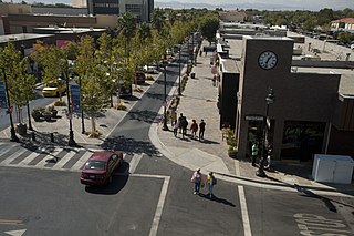
Palmdale is a city in northern Los Angeles County in the U.S. state of California. The city lies in the Antelope Valley of Southern California. The San Gabriel Mountains separate Palmdale from the Los Angeles Basin to the south.

Arthur B. Ripley Desert Woodland State Park is a state park in the western Antelope Valley in Southern California. The park protects mature stands of Joshua trees and California juniper trees in their western Mojave Desert habitat.

The Antelope Valley is located in northern Los Angeles County, California, United States, and the southeast portion of California's Kern County, and constitutes the western tip of the Mojave Desert. It is situated between the Tehachapi, Sierra Pelona, and the San Gabriel Mountains. The valley was named for the pronghorns that roamed there until they were all eliminated in the 1880s, mostly by hunting, or resettled in other areas. The principal cities in the Antelope Valley are Palmdale and Lancaster.

Pearblossom is an unincorporated community located in the Antelope Valley of the Mojave Desert, in northern Los Angeles County, California, United States.

Antelope Acres is an unincorporated community in Los Angeles County, California. It lies at an elevation of 2425 feet.

Del Sur is an unincorporated community in the Mojave Desert, in Los Angeles County, California. The town has a population of about 1,750. The ZIP Code is 93536 and the community is inside area code 661.

Llano is an unincorporated community located in Los Angeles County, California, United States, near the San Bernardino County line. The town has a population of about 1,200.

Leona Valley is a census-designated place located in the geographic Leona Valley of northern Los Angeles County, California, in the transition between the Sierra Pelona Mountains and Mojave Desert, just west of Palmdale and the Antelope Valley. The population was 1,607 at the 2010 census.
The Antelope Valley Press, colloquially referred to as the Valley Press or AV Press by its staff and Antelope Valley residents, is the largest-circulation daily newspaper in Palmdale, California, United States. It had been a family-owned business since beginning as a weekly newspaper in 1915, until June 30, 2017, when it was assimilated into Canadian publisher Steven Malkowich's consortium of holdings.
Sun Village is an unincorporated community and census-designated place (CDP) in Los Angeles County, California, United States. It is in the eastern Antelope Valley at an elevation of 2,723 feet (830 m). The center of Sun Village may be considered to be Palmdale Boulevard and 87th Street East as noted at the Los Angeles County Assessors office. As of the 2010 census the population of Sun Village was 11,565, up from 9,375 at the 2000 census.

Area code 661 is a telephone area code in the North American Numbering Plan for the southern part of the San Joaquin Valley and for the far northern part of the Los Angeles metropolitan area. The numbering plan area comprises most of Kern County, most of northern Los Angeles County, and small parts of Ventura County, Santa Barbara County, and Tulare County. It was created in an area code split of area code 805 on February 13, 1999.

Surprise Valley is a valley in extreme northeastern California, about 60 miles in length from north to south. Locals refer to the area as the Tricorner Region because of the region's location at the intersection of California, Oregon, and Nevada state lines. The valley is east of the Modoc County seat of Alturas. The area is part of the Great Basin which extends across most of the northern half of Nevada.

Elizabeth Lake is a natural sag pond that lies directly on the San Andreas Fault in the northern Sierra Pelona Mountains, in northwestern Los Angeles County, southern California.

The Sierra Pelona, also known as the Sierra Pelona Ridge or the Sierra Pelona Mountains, is a mountain ridge in the Transverse Ranges in Southern California. Located in northwest Los Angeles County, the ridge is bordered on the north by the San Andreas fault and lies within and is surrounded by the Angeles National Forest.

High Desert is a vernacular region with non-discrete boundaries covering areas of the western Mojave Desert in Southern California. The region encompasses various terrain with elevations generally between 2,000 and 4,000 ft above sea level, and is located just north of the San Gabriel, San Bernardino, and Little San Bernardino Mountains.

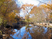
Lake Palmdale is an artificial lake completed in 1924 along with the nearby Little Rock Reservoir created by Little Rock Dam. Its source of water is the California State Water Project and it is fed by the California Aqueduct. It is located in the city of Palmdale near the city's southern edge, in the small Anaverde Valley between the San Andreas Fault and the base of Mount Tenhi.

Desert Christian Schools, or DCS, is a private Christian school in Lancaster, California. DCS shares their property with Grace Chapel. DCS uses RenWeb as their school management system.
St. Andrew's Abbey, Bruges was a Benedictine abbey in Sint-Andries, Bruges, Belgium, which was destroyed in the French Revolution. Its modern successor St. Andrew's Abbey, Zevenkerken, founded in 1899–1900, is a Benedictine abbey of the Congregation of the Annunciation.

The Congregation of the Annunciation, formerly known as the Belgian Congregation, is a congregation of monasteries within the Roman Catholic Benedictine Confederation. Founded in 1920, the Congregation includes fifteen independent male monasteries spread throughout ten countries. Additionally, two female monasteries are members of the Congregation, while a further ten are affiliated with the Congregation.