Rolling Hills, California

Last updated

Rolling Hills, California
Seal of City of Rolling Hills, California.png
LA County Incorporated Areas Rolling Hills highlighted.svg
Location of Rolling Hills in Los Angeles County, California
Usa edcp relief location map.png
Red pog.svg
Rolling Hills, California
Location in the United States
Coordinates: 33°45′34″N118°20′30″W / 33.75944°N 118.34167°W / 33.75944; -118.34167
Country United States
State California
County Los Angeles
Incorporated January 24, 1957 [1]
Government
  Type Council-Manager [2]
   Mayor James Black [3]
   City Manager Elaine Jeng, P.E
Area
[4]
  Total2.99 sq mi (7.75 km2)
  Land2.99 sq mi (7.75 km2)
  Water0.00 sq mi (0.00 km2)  0%
Elevation
[5]
1,276 ft (389 m)
Population
 (2020) [6]
  Total1,739
  Density580/sq mi (220/km2)
Time zone UTC-8 (Pacific)
  Summer (DST) UTC-7 (PDT)
ZIP code
90274
Area codes 310/424
FIPS code 06-62602
GNIS feature IDs 1661325, 2410986
Website www.rolling-hills.org

Rolling Hills is a city on the Palos Verdes Peninsula, in Los Angeles County, California, United States. Rolling Hills is a gated community with private roads with three entry gates. Homes are single-story 19th century California ranch or Spanish haciendas exemplified by architect Wallace Neff. Incorporated in 1957, Rolling Hills maintains a rural and equestrian character, with no traffic lights, multi-acre lots with ample space between homes, and wide equestrian paths along streets and property lines. [7]

Contents

Rolling Hills has the third highest median house value in the United States. [8] [9] Homes are required to have white exterior paint. [7] Homeowners are also required to maintain horse property on their lots, or at minimum keep land where stalls could be built. [7] The community was developed by A. E. Hanson, who also developed Hidden Hills. [10]

Residents work, shop, attend school, and obtain other services in the other towns on the Palos Verdes Peninsula as the only commercially zoned land within the city is occupied by the Rolling Hills City Hall, Rolling Hills Community Association, and LA County Fire Department Station 56. As of the 2020 census, the city population was 1,739, down from 1,860 at the 2010 census.

Geography

Manuel Dominguez, a signer of the Californian Constitution and owner of Rancho San Pedro, which included all of Palos Verdes. Manuel Dominguez of California.jpg
Manuel Domínguez, a signer of the Californian Constitution and owner of Rancho San Pedro, which included all of Palos Verdes.
In 1846, Rancho de los Palos Verdes was separated from Rancho San Pedro and granted to Jose Loreto Sepulveda (shown) and Juan Capistrano Sepulveda. Jose Loreto Sepulveda.jpg
In 1846, Rancho de los Palos Verdes was separated from Rancho San Pedro and granted to José Loreto Sepúlveda (shown) and Juan Capistrano Sepúlveda.

The city borders Rolling Hills Estates to the north and Rancho Palos Verdes on all other sides (including the empty Portuguese Bend landslide area to the south).

Rolling Hills is located at 33°45′34″N118°20′30″W / 33.75944°N 118.34167°W / 33.75944; -118.34167 (33.759350, −118.341550). [11]

According to the United States Census Bureau, the city has a total area of 3.0 square miles (7.8 km2), all land.

Demographics

Historical population
CensusPop.Note
1960 1,664
1970 2,05023.2%
1980 2,0490.0%
1990 1,871−8.7%
2000 1,8710.0%
2010 1,860−0.6%
2020 1,739−6.5%
U.S. Decennial Census [12]

At the 2000 census, Rolling Hills was the 21st richest place in the United States (based upon per capita income), and 4th richest for places with a population of at least 1,000.

2010

At the 2010 census Rolling Hills had a population of 1,860. The population density was 622.0 inhabitants per square mile (240.2/km2). The racial makeup of Rolling Hills was 1,437 (77.3%) White (74.1% Non-Hispanic White), [13] 29 (1.6%) African American, 5 (0.3%) Native American, 303 (16.3%) Asian, 2 (0.1%) Pacific Islander, 24 (1.3%) from other races, and 60 (3.2%) from two or more races. Hispanic or Latino of any race were 102 people (5.5%). [14]

The whole population lived in households, no one lived in non-institutionalized group quarters and no one was institutionalized.

There were 663 households, 199 (30.0%) had children under the age of 18 living in them, 491 (74.1%) were opposite-sex married couples living together, 27 (4.1%) had a female householder with no husband present, 21 (3.2%) had a male householder with no wife present. There were 11 (1.7%) unmarried opposite-sex partnerships, and 9 (1.4%) same-sex married couples or partnerships. 98 households (14.8%) were one person and 66 (10.0%) had someone living alone who was 65 or older. The average household size was 2.81. There were 539 families (81.3% of households); the average family size was 3.08.

The age distribution was 404 people (21.7%) under the age of 18, 109 people (5.9%) aged 18 to 24, 191 people (10.3%) aged 25 to 44, 643 people (34.6%) aged 45 to 64, and 513 people (27.6%) who were 65 or older. The median age was 51.7 years. For every 100 females, there were 91.8 males. For every 100 females age 18 and over, there were 91.1 males.

There were 663 occupied housing units at an average density of 239.4 per square mile (92.4/km2), of which 635 were owner-occupied, and 28 were occupied by renters. The homeowner vacancy rate was 1.4%; the rental vacancy rate was 3.4%. 1,778 people (95.6% of the population) lived in owner-occupied housing units and 82 people (4.4%) lived in rental housing units.

2000

At the 2000 census there were 1,871 people in 645 households, including 554 families, in the city. The population density was 607.7 inhabitants per square mile (234.6/km2). There were 682 housing units at an average density of 221.5 per square mile (85.5/km2). The racial makeup of the city was 79.8% White, 2.0% African American, 14.0% Asian, 0.5% Pacific Islander, 1.2% from other races, and 2.5% from two or more races. Hispanic or Latino of any race were 4.5%. [15]

Of the 645 households 33.8% had children under the age of 18 living with them, 80.6% were married couples living together, 3.4% had a female householder with no husband present, and 14.1% were non-families. 12.4% of households were one person and 8.1% were one person aged 65 or older. The average household size was 2.90 and the average family size was 3.11.

The age distribution was 25.9% under the age of 18, 4.1% from 18 to 24, 15.1% from 25 to 44, 32.8% from 45 to 64, and 22.1% 65 or older. The median age was 48 years. For every 100 females, there were 96.1 males. For every 100 females age 18 and over, there were 92.5 males.

The median household income was in excess of $200,000, as was the median family income. Males had a median income in excess of $100,000 versus $52,500 for females. The per capita income for the city was $111,031. None of the families and 1.3% of the population were below the poverty line. No one under 18 or older than 65 was living below the poverty line.

Education

The city is served by Palos Verdes Peninsula Unified School District. PVPUSD schools have constantly ranked among the best in California and the nation. Since 2013, the Washington Post has consistently recognized Palos Verdes Peninsula High School in the publication's list of "America's Most Challenging Schools" and once listed it as the 8th best public or private high school in the nation. [16] School data website, niche.com ranked Palos Verdes Peninsula High School #9 of California's best public high schools of 2016. [17] The prestigious Chadwick School is an independent 45 acre, K-12 private school that also serves the area. According to Business Insider, in 2014 niche.com named Chadwick as one of the top private high schools in America. [18]

Politics

In 2009, Rolling Hills had the third highest percentage of registered Republicans of any city in California, with 61.3% of its 1,441 registered voters registered as Republicans. 19.4% of voters were registered Democrats, and 16.3% "declined to state." [19]

As of February 10, 2021, there were 1,577 registered voters in Rolling Hills, California. Of these voters, 737 (46.73%) were registered with the Republican party, 388 (24.60%) were registered with the Democratic Party, 357 (22.64%) were not affiliated with a political party, and 95 (6.02%) were registered with a third party. According to that same report, Rolling Hills is one of only ten incorporated municipalities in Los Angeles County that has more registered Republicans than registered Democrats, out of 87 total. [20]

Rolling Hills has voted for the Republican candidate in every presidential and gubernatorial election since its incorporation, often by large margins. In 2016, Los Angeles County gave Donald Trump roughly 21% of the vote, and Rolling Hills was one of only five cities in Los Angeles County that was carried by Trump. [21] In 2020, the city supported Trump's re-election bid by a margin of 11.84%. This was the lowest margin of victory for a Republican presidential candidate since Rolling Hills's formal incorporation as a city.

Government

Rolling Hills was incorporated in 1957. It has a council-manager form of government. The city council consists of five members, one of whom is appointed mayor on an annual basis. [3]

State and federal representation

In the California State Legislature, Rolling Hills is in the 26th Senate District , represented by Democrat María Elena Durazo, and in the 66th Assembly District , represented by Democrat Al Muratsuchi. [22]

In the United States House of Representatives, Rolling Hills is in California's 33rd congressional district , represented by Democrat Pete Aguilar. [23]

Services

The Los Angeles County Sheriff's Department (LASD) operates the Lomita Station in Lomita, serving Rolling Hills. [24]

The Los Angeles County Department of Health Services operates the Torrance Health Center in Harbor Gateway, Los Angeles, near Torrance and serving Rolling Hills. [25]

Notable people

See also

Related Research Articles

<span class="mw-page-title-main">Los Angeles Community College District</span> Community college district in Los Angeles, California, United States

The Los Angeles Community College District (LACCD) is the community college district serving Los Angeles, California, and some of its neighboring cities and certain unincorporated areas of Los Angeles County. Its headquarters are in Downtown Los Angeles. Over the past seventy-seven years, LACCD has served as educator to more than three million students. In addition to typical college aged students, the LACCD also serves adults of all ages: over half of all LACCD students are older than 25 years of age, and more than a quarter are 35 or older. LACCD educates almost three times as many Latino students and nearly four times as many African-American students as all of the University of California campuses combined. Eighty percent of LACCD students are from underserved populations. The Los Angeles Community College District is the largest community college district in the United States and is one of the largest in the world. The nine colleges within the district offer educational opportunities to students in Los Angeles. It serves students located in the Alhambra, Beverly Hills, Burbank, Culver City, Garvey, Las Virgenes, Los Angeles, Montebello, Palos Verdes and San Gabriel school districts. The district covers the Los Angeles city limits, San Fernando, Calabasas, Agoura Hills, Hidden Hills, Burbank, West Hollywood, Beverly Hills, Culver City, Alhambra, Monterey Park, San Gabriel, Rosemead, Montebello, Commerce, Vernon, Huntington Park, Bell, Cudahy, Bell Gardens, South Gate, Gardena, Carson, Lomita, Palos Verdes Estates, Rolling Hills, Rancho Palos Verdes, and numerous unincorporated communities, including East Los Angeles, Florence-Firestone, Athens, and Walnut Park. The LACCD consists of nine colleges and covers an area of more than 882 square miles (2,280 km2).

<span class="mw-page-title-main">South Bay (Los Angeles County)</span> Region in California, United States

The South Bay is a region of the Los Angeles metropolitan area, located in the southwest corner of Los Angeles County. The name stems from its geographic location stretching along the southern shore of Santa Monica Bay. The South Bay contains sixteen cities plus portions of the City of Los Angeles and unincorporated portions of the county. The area is bounded by the Pacific Ocean on the south and west and generally by the City of Los Angeles on the north and east.

<span class="mw-page-title-main">Merced County, California</span> County in California, United States

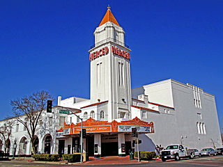
Merced County, is a county located in the northern San Joaquin Valley section of the Central Valley, in the U.S. state of California.

<span class="mw-page-title-main">Menlo Park, California</span> City in California, United States

Menlo Park is a city at the eastern edge of San Mateo County within the San Francisco Bay Area of California, United States. It is bordered by San Francisco Bay on the north and east; East Palo Alto, Palo Alto, and Stanford to the south; and Atherton, North Fair Oaks, and Redwood City to the west. It had 33,780 residents at the 2020 United States census. It is home to the corporate headquarters of Meta, and is where Google, Roblox Corporation and Round Table Pizza were founded. The train station holds the record as the oldest continually operating train station in California. It is one of the most educated cities in California and the United States; nearly 70% of residents over 25 have earned a bachelor's degree or higher.

<span class="mw-page-title-main">Palo Verde, California</span> Census-designated place in California, United States

Palo Verde is a census-designated place (CDP) in Imperial County, California. Its name comes from the native desert tree, Palo Verde, which in turn takes its name from the Spanish for stick (palo) and green (verde), sharing its name with the Palo Verde Valley, the valley it is located.

<span class="mw-page-title-main">Lawndale, California</span> City in California, United States

Lawndale is a city in Los Angeles County, California, United States. The population was 32,769 at the 2010 census, up from 31,712 according to the 2000 census. The city is in the South Bay region of the Greater Los Angeles Area.

<span class="mw-page-title-main">Lomita, California</span> City in California, United States

Lomita is a city in Los Angeles County, California, United States. The population was 20,921 at the 2020 census, up slightly from 20,256 at the 2010 census.

<span class="mw-page-title-main">Palos Verdes Estates, California</span> City in California, United States

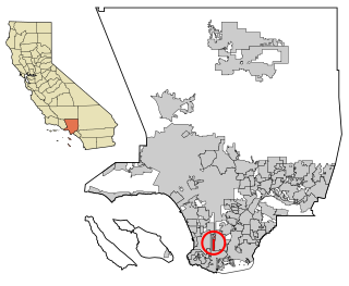
Palos Verdes Estates is a coastal city in Los Angeles County, California, United States, situated on the Palos Verdes Peninsula and neighboring Rancho Palos Verdes and Rolling Hills Estates. The city was master-planned by the noted American landscape architect and planner Frederick Law Olmsted Jr. The city is located along the Southern California coastline of the Pacific Ocean.

<span class="mw-page-title-main">Quartz Hill, California</span> Census-designated place in California, United States

Quartz Hill is a census-designated place (CDP) in Los Angeles County, California, United States. The population was 10,912 at the 2010 census, up from 9,890 at the 2000 census. The name is also shared with the neighboring district areas of its border cities, Palmdale, and Lancaster. Quartz Hill was once home to the Quartz Hill Airport. According to the Greater Antelope Valley Economic Alliance report of 2009, the Palmdale / Lancaster urban area of which Quartz Hill is a part, has a population of 483,998.

<span class="mw-page-title-main">Rancho Palos Verdes, California</span> City in California, United States

Rancho Palos Verdes is a coastal city located in south Los Angeles County, California. Incorporated on September 7, 1973, the city has a population of 42,287 as reported in the 2020 United States Census. Rancho Palos Verdes sits atop the bluffs of the Palos Verdes Peninsula, neighboring three other cities in the Palos Verdes Hills, namely Palos Verdes Estates, Rolling Hills, and Rolling Hills Estates. It is known for its extensive nature preserves and hiking trails, school district, as well as high property values.

<span class="mw-page-title-main">Val Verde, California</span> Unincorporated community in Los Angeles County, California

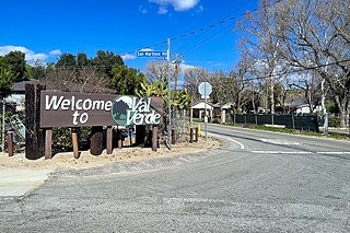
Val Verde is an unincorporated community in the southeastern Topatopa Mountains foothills, and in northwestern Los Angeles County, California. The unincorporated community of Valencia is southeast, and the city of Santa Clarita is east of the community. Its population was 2,468 at the 2010 census, up from 1,472 at the 2000 census. For statistical purposes the Census Bureau has defined Val Verde as a census-designated place (CDP).

<span class="mw-page-title-main">West Carson, California</span> Unincorporated community in California, United States

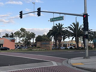
West Carson is an unincorporated community in the South Bay region of Los Angeles County, California. The population was 22,870 at the 2020 census. For statistical purposes, the United States Census Bureau has defined West Carson as a census-designated place (CDP).

<span class="mw-page-title-main">Dos Palos, California</span> City in Merced County, California, United States

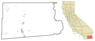
Dos Palos is a city in southern Merced County, California, United States. Dos Palos is located 27 miles (43 km) south-southwest of Merced, the county seat, at an elevation of 118 feet (36 m). The population was 5,798 at the 2020 census, up from 4,950 at the 2010 census.

<span class="mw-page-title-main">Blythe, California</span> City in California, United States

Blythe is a city in eastern Riverside County, California, United States. It is in the Palo Verde Valley of the Lower Colorado River Valley region, an agricultural area and part of the Colorado Desert along the Colorado River, approximately 224 miles (360 km) east of Los Angeles and 150 miles (240 km) west of Phoenix. Blythe was named after Thomas Henry Blythe, a San Francisco financier, who established primary water rights to the Colorado River in the region in 1877. The city was incorporated on July 21, 1916. The population was 18,317 at the 2020 census.

<span class="mw-page-title-main">Chino Hills, California</span> City in California, United States

Chino Hills is a city located in the southwestern corner of San Bernardino County, California, United States. The city borders Los Angeles County on its northwest side, Orange County to its south and southwest, and Riverside County to its southeast.

<span class="mw-page-title-main">Rolling Hills Estates, California</span> City in California, United States

Rolling Hills Estates is a city in Los Angeles County, California, United States. On the northern side of the Palos Verdes Peninsula, facing Torrance, Rolling Hills Estates is mostly residential. Incorporated in 1957, Rolling Hills Estates has many horse paths. The population was 8,067 at the 2010 census, up from 7,676 at the 2000 census. In 2018, the population rose to 8,141, and the 2020 census counted 8,280 residents.

<span class="mw-page-title-main">San Pedro, Los Angeles</span> Neighborhood of Los Angeles in California, United States

San Pedro is a neighborhood located within the South Bay and Harbor region of the City of Los Angeles, California, United States. Formerly a separate city, it consolidated with Los Angeles in 1909. The Port of Los Angeles, a major international seaport, is partially located within San Pedro. The district has grown from being dominated by the fishing industry, to a working-class community within the city of Los Angeles, to an increasingly dense and diverse community.

<span class="mw-page-title-main">Palos Verdes Peninsula</span> Sub-region of the Los Angeles metropolitan area in California, United States

The Palos Verdes Peninsula is a peninsula and sub-region of the Los Angeles metropolitan area, located within southwestern Los Angeles County in the U.S. state of California. Located in the South Bay region, the peninsula contains a group of cities in the Palos Verdes Hills, including Palos Verdes Estates, Rancho Palos Verdes, Rolling Hills and Rolling Hills Estates, as well as the unincorporated community of Westfield/Academy Hill. The South Bay city of Torrance borders the peninsula on the north, the Pacific Ocean is on the west and south, and the Port of Los Angeles is east. As of the 2010 Census, the population of the Palos Verdes Peninsula is 65,008.

Palos Verdes Peninsula Unified School District (PVPUSD) is a school district headquartered in Palos Verdes Estates, California with facilities in all four cities of the Palos Verdes Peninsula.

<span class="mw-page-title-main">Riverside County, California</span> County in California, United States

Riverside County is a county located in the southern portion of the U.S. state of California. As of the 2020 census, the population was 2,418,185, making it the fourth-most populous county in California and the 10th-most populous in the United States. The name was derived from the city of Riverside, which is the county seat.

References

  1. "California Cities by Incorporation Date". California Association of Local Agency Formation Commissions. Archived from the original (Word) on November 3, 2014. Retrieved August 25, 2014.
  2. "City Manager". City of Rolling Hills. Retrieved February 16, 2015.
  3. 1 2 "City Council". Rolling Hills, CA. Retrieved March 30, 2015.
  4. "2019 U.S. Gazetteer Files". United States Census Bureau. Retrieved July 1, 2020.
  5. "Rolling Hills". Geographic Names Information System . United States Geological Survey, United States Department of the Interior . Retrieved November 11, 2014.
  6. "Census Data: Rolling Hills (city)". United States Census Bureau . Retrieved July 14, 2021.
  7. 1 2 3 "History of Palos Verdes Real Estate in Rolling Hills". PVBrokers.net. Retrieved March 25, 2015.
  8. "Top 100 cities with highest median house value". city-data.com. Retrieved March 25, 2015.
  9. Slater, Eric (June 13, 1996). "Rolling Hills Named Richest in Nation". Los Angeles Times. Retrieved April 8, 2018.
  10. Becker, Maki (November 1, 1996). "The founder of Rolling Hills wanted to..." Los Angeles Times. Retrieved March 2, 2021.
  11. "US Gazetteer files: 2010, 2000, and 1990". US Census Bureau. February 12, 2011. Retrieved April 23, 2011.
  12. "Census of Population and Housing". Census.gov. Retrieved June 4, 2015.
  13. "Profile of General Population and Housing Characteristics: 2010". Census.gov. US Census Bureau, US Dept. of Commerce. Retrieved March 25, 2015.
  14. "2010 Census Interactive Population Search: CA - Rolling Hills city". US Census Bureau. Archived from the original on July 15, 2014. Retrieved July 12, 2014.
  15. "U.S. Census website". US Census Bureau . Retrieved January 31, 2008.
  16. "Palos Verdes Peninsula High School Ranking". Washington Post.
  17. "California's Best Public High Schools 2016". niche.com.
  18. "Best Private High Schools in America 2014". Business Insider.
  19. "Registration by Political Subdivision by County" (PDF). California Secretary of State. May 4, 2009. pp. 103–190. Archived from the original (PDF) on March 29, 2012. Retrieved March 27, 2015.
  20. https://elections.cdn.sos.ca.gov/ror/ror-odd-year-2021/politicalsub.pdf [ bare URL PDF ]
  21. "Election data" (PDF). elections.cdn.sos.ca.gov. Retrieved August 8, 2020.
  22. "Statewide Database". UC Regents. Archived from the original on February 1, 2015. Retrieved February 11, 2015.
  23. "California's 33rd Congressional District - Representatives & District Map". Civic Impulse, LLC.
  24. "Lomita Station Archived January 23, 2010, at the Wayback Machine ." Los Angeles County Sheriff's Department. Retrieved on January 21, 2010.
  25. "LA County Department of Public Health" (PDF). publichealth.lacounty.gov. Retrieved May 16, 2024.
  26. "Tracy Austin: 'I had won four Porsches by the age of 18". The Telegraph. June 29, 2015. Retrieved May 16, 2024.
  27. Armstrong, Kevin; Mehta, Manish (September 20, 2011). "Nick Mangold out two-to-three weeks with high ankle sprain, Jets turn to reserve center Colin Baxter". Daily News . New York. Retrieved December 21, 2013.
  28. Foss, Richard (April 30, 2012). "Castle Rock Winery Partners – A remote peninsula winery". Easy Reader News. Retrieved December 13, 2019.
  29. "Frank Robinson". Blockshopper.com.
  30. "John Tu". Forbes.