Velddrif

Last updated
Velddrif
Velddrif.jpg
Bokkoms Velddrif - West Coast, South Africa (3918637765).jpg
Velddrif Bird View.jpg
Port Owen at Velddrif.jpg
Langrietvlei opstal.jpg
From top, fishing piers on the Berg River. Left middle, a fisherman and his catch. Right middle, Bird's eye view of Velddirf. Below left, Port Owen at Velddrift. Below right, Farmhouse between Hopefield and Velddrif.
South Africa Western Cape location map.svg
Red pog.svg
Velddrif
South Africa adm location map.svg
Red pog.svg
Velddrif
Coordinates: 32°47′S18°10′E / 32.783°S 18.167°E / -32.783; 18.167
Country South Africa
Province Western Cape
District West Coast
Municipality Bergrivier
Area
[1]
  Total8.87 km2 (3.42 sq mi)
Population
 (2022) [1]
  Total17,043
  Density1,900/km2 (5,000/sq mi)
Racial makeup (2011)
[1]
   Black African 12.2%
   Coloured 57.1%
   Indian/Asian 0.5%
   White 29.6%
  Other0.6%
First languages (2011)
[1]
   Afrikaans 83.5%
   Xhosa 8.7%
   English 5.8%
  Other2.1%
Time zone UTC+2 (SAST)
Postal code (street)
7365
PO box
7365
Area code 022

Velddrif (the name of the town) or Velddrift (the name of the farm on which the town was established), is a coastal fishing town in the Bergrivier Local Municipality, Western Cape, South Africa. The town had a population 12507 in 2015 [2] and is located on the estuary at which the Berg River flows into St. Helena Bay.

Contents

Geography and environment

Velddrif is located approximately 145 kilometres (90 mi) north of Cape Town to which it is connected by the R27 road. [3] The R27 joins the R399 at Velddrif, which is near the point at which the meandering Berg River flows into the sea at St. Helena Bay. The estuary is an important bird habitat and is home to around 30,000 birds, including up to 80 species which are endemic to the Cape coast. [2] Well over 350 different species of birds can be seen here, as it is a habitat for sea, river and land birds.

Flowers grow in this area, including the Euclea racemosa (Kersbos), Babiana ringens (Rotstert), Willdenowia incurvata (Sonkwas Riet), Limonium (Strandroos) and Leucospermum rodolentum (Sandveld Luisebos). [2] Regular boat trips can be taken up the river for birdwatching. [4]

History

The name Velddrif is derived from a drift in the field (Afrikaans : veld) through which a local farmer, Theunis Smit, took his stock to access grazing across the Berg River. [4] In 1899, a pont (pontoon ferry) was built to cross the Berg River. [4]

Economy

The main industries of Velddrif are fishing, tourism and salt production. There are two large salt works in the town that provide much of the salt in the Western Cape. The fishing industry is substantial in Velddrif; the town is part of the Crayfish Route. A common sight in the area are the rickety wooden jetties on which the dried fish speciality, bokkoms , is hung out to dry. [2] [3] The town contains Port Owen, which comprises 100 hectares and has 3.5 km of waterways.

The town attracts a number of tourists, especially for its wildlife, fishing, yachting and art galleries, which represents the work of over 100 artists and craftsmen in the area. [3] [4] Birdwatching is a significant component of the town's tourism sector, as the Berg River Estuary, next to the town, is famous as a rare bird hotspot with over 200 species found in the 24,000 ha wetland. [5] [6]

There are numerous restaurants in Velddrif and nearby Laaiplek(which is a neighbourhood of Velddrif) that serve fresh fish and other seafood. A holiday resort has grown up around the marina area of Port Owen and Admiral Island Security Village. [7] The annual Berg River Canoe Marathon starts in Paarl and ends at the Carinus Bridge Velddrif. [3] [7] The first Berg River Canoe Marathon was held in 1962, has gained a reputation for being one of the toughest courses in the world and is the longest course in South Africa. Ayesha Abdool Aziz, who hails from Edgemead Primary, holds the current record for the group aged under 9. [8]

Education

Hoërskool Velddrif [Velddrif High School] is a public high school in Velddrif, Western Cape, South Africa. It is an Afrikaans combined upper and lower secondary school with approximately 500 students.

Hoërskool Velddrif was founded in 1890 as a private school.

List of school principals
YearsName
1890–1893Daniël Orffer
1894–1925P.J. Geldenhuys
1925–1926I.J. Smit
1927–1931A.P. Viljoen
1932–1936C.J. Potgieter
1936–1943J.H. Burger
1944–1966P.J. Louw
1967–1982G. Nieuwoudt
1982–1996D.J.E. Smit
1996–2012D.J.A. Brand
2013–2022A. van der Westhuizen
2022-L. van Rensburg (Acting)
Hoerskool Velddrif Vellies2017.jpg
Hoërskool Velddrif

The school crest represents the environs of Velddrif. Five wavy white lanes represent water, namely the Berg River and the sea. The boat is a stylized version of a fishing boat, honoring Velddrif's fishing industry, on which the town's economy was largely built. The bridge indicates the bridge between youth and adulthood. The sun relates to the schools motto: "Strive Higher."

Related Research Articles

<span class="mw-page-title-main">Plettenberg Bay</span> Place in Western Cape, South Africa

Plettenberg Bay, nicknamed Plett, is the primary town of the Bitou Local Municipality in the Western Cape Province of South Africa. As of the census of 2001, there were 29,149 population. It was originally named Bahia Formosa by early Portuguese explorers and lies on South Africa's Garden Route 210 km from Port Elizabeth and about 600 km from Cape Town.

<span class="mw-page-title-main">Bergrivier Local Municipality</span> Local municipality in Western Cape, South Africa

Bergrivier Municipality is a local municipality in the Western Cape province of South Africa. It governs the towns of Piketberg, Velddrif and Porterville, as well as the surrounding villages and rural areas. As of 2011, it had a population of 61,897. It is located within the West Coast District Municipality and its municipality code is WC013.

<span class="mw-page-title-main">Saldanha Bay Local Municipality</span> Local municipality in Western Cape, South Africa

Saldanha Bay Municipality is a local municipality located within the West Coast District Municipality, in the Western Cape province of South Africa. As of 2011, it had a population of 99,193. Its municipality code is WC014.

<span class="mw-page-title-main">Strand, Western Cape</span> Seaside town in the Western Cape, South Africa

Strand is a seaside resort town in the Western Cape, South Africa. It forms part of the Eastern Suburbs of the City of Cape Town Metropolitan Municipality, situated on the north-eastern edge of False Bay and near the foot of the Helderberg Mountains. Its geographical position is between Somerset West and Gordon's Bay, and is about 50 km southeast of Cape Town City Bowl. Strand has a population of approximately 50,000. Strand's main attraction is the beach; 5 km of white sandy beach off False Bay.

<span class="mw-page-title-main">Great Fish River</span> River in the Eastern Cape, South Africa

The Great Fish River is a river running 644 kilometres (400 mi) through the South African province of the Eastern Cape. The coastal area between Port Elizabeth and the Fish River mouth is known as the Sunshine Coast. The Great Fish River was originally named Rio do Infante, after João Infante, the captain of one of the caravels of Bartolomeu Dias. Infante visited the river in the late 1480s.

<span class="mw-page-title-main">R27 (South Africa)</span> Road in South Africa

The R27 is a provincial route in South Africa that consists of two disjoint segments. The first segment, also known as the West Coast Highway, connects Cape Town with Velddrif along the West Coast. The second runs from Vredendal via Vanrhynsdorp, Calvinia, Brandvlei and Kenhardt to Keimoes on the N14 near Upington. The connection between Velddrif and Vredendal has never been built, although it can be driven on various gravel roads.

<span class="mw-page-title-main">Berg River</span> River in the Western Cape, South Africa

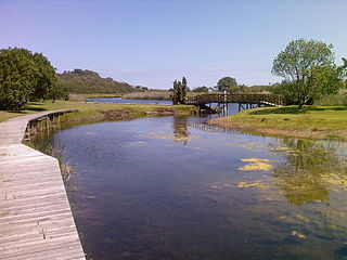
The Berg River is a river located just north of Cape Town in the Western Cape Province of South Africa. It is approximately 294 km (183 mi) long with a catchment area of 7,715 km2 (2979 mi2) and empties into the Atlantic Ocean. About 65% of the Berg River area is under agriculture. The major towns in the Berg River area are Velddrif and Laaiplek near the coast, and Piketberg, Hopefield, Moorreesburg and Darling further inland.

<span class="mw-page-title-main">Jeffreys Bay</span> Town in Eastern Cape, South Africa

Jeffrey's Bay is a town of 27,107 inhabitants as of the 2011 census in the Eastern Cape province of South Africa. It Is the seat of the Kouga municipality and is famous amongst surfers as a surf capital due to the right-hand point break at Supertubes Beach. The town is situated just off the N2 Highway, about 75 kilometres southwest of Port Elizabeth.

<span class="mw-page-title-main">Ythan Estuary</span>

The Ythan Estuary is the tidal component of the Ythan River, emptying into the North Sea 19 kilometres (12 mi) north of Aberdeen, Scotland. The estuary’s tidal action extends a 7 kilometres (4.3 mi) inland and has characteristic widths of between 250 metres (820 ft) and 780 metres (2,560 ft). Besides the tidal channel there are interfaces to the upland dunes including mudflats, sand beaches and shingle flats. Reaches of salt marsh occur, but they are primarily near the Waterside Bridge and the mouth of the Tarty Burn, a small tributary river. Based upon the habitat of the moorland bordering the east of the Ythan River near the mouth, this estuary is the most significant coastal moorland in the northern United Kingdom.

<span class="mw-page-title-main">Dangme East District</span> Former District in Ghana

Dangme East District is a former district that was located in Greater Accra Region, Ghana. Originally created as an ordinary district assembly in 1988, which was created from the former Dangme District Council. However on 28 June 2012, it was split off into two new districts: Ada East District and Ada West District. The district assembly was located in the eastern part of Greater Accra Region and had Ada Foah as its capital town.

Fisherhaven is a suburb of the whale watching town of Hermanus in the Western Cape, South Africa. It is situated next to the Bot River Lagoon, about 14 km from Hermanus center and about 14 km from Arabella Country Estate and Golf course. There is an abundance of indigenous fauna and flora.

<span class="mw-page-title-main">Bokkoms</span> Whole, salted and dried mullet

Bokkoms is whole, salted and dried mullet, and is a well-known delicacy from the West Coast region of South Africa. This salted fish is dried in the sun and wind and is eaten after peeling off the skin. In some cases it is also smoked. It is sometimes referred to as "fish biltong".

<span class="mw-page-title-main">Riebeek West</span> Place in Western Cape, South Africa

Riebeek West is a small town situated about 75 km north-east of Cape Town and 5 km north of its twin town Riebeek Kasteel in the Swartland area of the Western Cape, South Africa.

<span class="mw-page-title-main">Langebaan</span> Place in Western Cape, South Africa

Langebaan is a town in the Western Cape province of South Africa on the eastern shore of Langebaan Lagoon.

<span class="mw-page-title-main">Port Owen</span> Marina in Velddrif, South Africa

Port Owen is a man-made marina in the town of Velddrif, 145 km from Cape Town, on the west coast of Western Cape Province, South Africa. Velddrif, which has incorporated the village of Laaiplek has the lowest crime statistics in South Africa according to the local police station. It comprises 100 hectares and has 3.5 km of waterways which were produced over 15 years of dredging to remove roughly a million tons of dredge.

<span class="mw-page-title-main">Wilderness National Park</span> National park around the seaside town of Wilderness, Western Cape, South Africa

Wilderness National Park, also called the Wilderness Section, is located around the seaside town of Wilderness between the larger towns of George and Knysna, in the Western Cape. It is a protected area of South Africa forming part of the Garden Route National Park.

<span class="mw-page-title-main">Berg River Canoe Marathon</span>

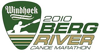
The Berg River Canoe Marathon takes place annually in South Africa's Western Cape Province over a distance of some 240 km from Paarl to the small harbour of Velddrif on the West Coast. The three other notable South African canoe races are the Dusi Canoe Marathon, the Breede River Canoe Marathon and the Fish River Canoe Marathon.

<span class="mw-page-title-main">Outline of canoeing and kayaking</span> Overview of and topical guide to canoeing and kayaking

Canoeing – recreational boating activity or paddle sport in which you kneel or sit facing forward in an open or closed-decked canoe, and propel yourself with a single-bladed paddle, under your own power.

Zandvlei Estuary Nature Reserve is a 300-hectare (740-acre) nature reserve and recreational area located in Muizenberg near Cape Town, South Africa.

<span class="mw-page-title-main">Morgan Bay</span> Place in Eastern Cape, South Africa

Morgan Bay is a village in Amathole District Municipality in the Eastern Cape province of South Africa.

References

  1. 1 2 3 4 "Main Place Velddrif". Census 2011.
  2. 1 2 3 4 "Velddrif". www.routes.co.za. Retrieved June 19, 2010.
  3. 1 2 3 4 Pinchuck, T., McCrea, B., Reid, D (2002). Rough Guide to South Africa, Lesotho & Swaziland. Rough Guides. pp. 289–90. ISBN   1-85828-853-3.{{cite book}}: CS1 maint: multiple names: authors list (link)
  4. 1 2 3 4 "Velddrif". Southern African Places. Retrieved June 19, 2010.
  5. "Birding". Velddrif Tourism. Retrieved 11 November 2015.
  6. "Berg River Estuary, Velddrif". Cape Birding Rout. Retrieved 11 November 2015.
  7. 1 2 Truter, Cornel (1998). West Coast Tourist Guide. Juta and Company Ltd. p. 86. ISBN   1-919713-24-7.
  8. "Berg River Canoe Marathon". www.southafrica.net. Retrieved June 19, 2010.