History
In 15 BC, the Roman general Nero Claudius Drusus, the stepson of Augustus, got orders from his stepfather to improve the passage through the Alps for military purposes and to increase Roman control over Rhaetia and Noricum. [3] The project of converting a pack-animal trail to serve wheeled vehicles was completed sixty years later in 46-47 AD by the son of Drusus, the Emperor Claudius. People and goods could pass between the Adriatic and the broad valley of the Po to Tridentum (modern Trento), then northward following the Adige River up to Pons Drusi, the "bridge of Drusus" which developed into Bolzano. Thence it continued towards Maia (near Merano), and over the Reschen Pass. From the pass it descended through the valleys of the Inn River and the Lech, just beyond Augusta Vindelicorum (Augsburg), with an extension to Burghoefe (Sumuntorium), now Mertingen near the Danube river and not far from the present-day town of Donauwörth; here the Via Claudia Augusta branched into the then important Roman military road running from West to East on the south side of the Danube river (via militaris iuxta riva danuvii or shorter via iuxta danuvii). This then important road is called by modern-day German historians Donausüdstrasse. It served to secure the Roman northern frontier, which was marked until the end of the first century by the Danube river.
Two milestones have been found, one at Rabland, a frazione of Partschins, near Merano in the South Tyrol [4] and the other in Cesiomaggiore, near Belluno. Both are inscribed with the far terminus of the Via Claudia Augusta, Augusta Vindelicorum (modern Augsburg). The milestones indicate that two routes joined at Tridentium before crossing the Alpine pass: one found its starting point at the vicus of Ostiglia, near the Po, the other, its site less securely identified by archaeologists and historians, at the Adriatic port of Altinum, (near the Venetian Lagoon). On its way to Tridentium, that route crossed the Via Annia, which linked Adria to Aquileia, the Via Popilia, which linked Altinum with Rimini, the Via Aurelia, between Padua and Feltre passing through Asolo, and the Via Postumia, the road linking Genoa and Aquileia. This road was initiated by Drusus as a military artery of conquest and defence, and Emperor Claudius continued its development as a cultural and commercial artery with permanently populated posting stations where fresh horses would be available. Some grew into considerable settlements and were fortified during the later Empire. Others can be identified only by the findings of archaeologists. In the 2nd century AD, a second Alpine pass was opened to wheeled traffic, the Brenner Pass.
This article concerns the period 19 BC – 10 BC.
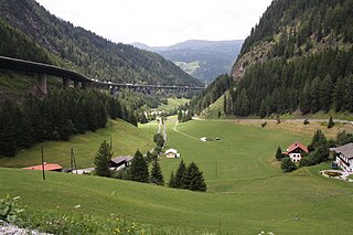
The Brenner Pass is a mountain pass over the Alps which forms the border between Italy and Austria. It is one of the principal passes of the Eastern Alpine range and has the lowest altitude among Alpine passes of the area.

Raetia or Rhaetia was a province of the Roman Empire, named after the Rhaetian people. It bordered on the west with the country of the Helvetii, on the east with Noricum, on the north with Vindelicia, on the south-west with Transalpine Gaul and on the south with Venetia et Histria, a region of Roman Italy.
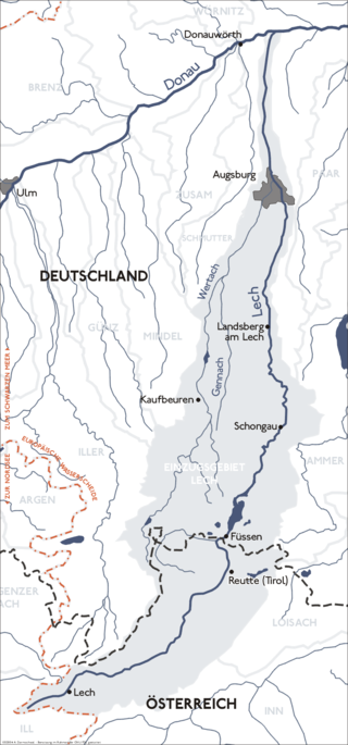
The Lech is a river in Austria and Germany. It is a right tributary of the Danube 255 kilometres (158 mi) in length with a drainage basin of 3,919 square kilometres (1,513 sq mi). Its average discharge at the mouth is 115 m3/s (4,100 cu ft/s). Its source is located in the Austrian state of Vorarlberg, where the river rises from lake Formarinsee in the Alps at an altitude of 1,870 metres (6,120 ft). It flows in a north-north-easterly direction and crosses the German border, forming the Lechfall, a 12-metre-high (39 ft) waterfall; afterwards the river enters a narrow gorge. Leaving the Alps, it enters the plains of the Allgäu at Füssen at an elevation of 790 metres (2,580 ft) in the German state of Bavaria, where it used to be the location of the boundary with Swabia. The river runs through the city of Füssen and through the Forggensee, a man-made lake which is drained in winter. Here, it forms rapids and a waterfall.

Bolzano is the capital city of the province of South Tyrol, in Northern Italy. With a population of 108,245, Bolzano is also by far the largest city in South Tyrol and the third largest in historical Tyrol. The greater metro area has about 250,000 inhabitants and is one of the urban centers within the Alps.
Augsburg is a Landkreis (district) in Swabia, Bavaria, Germany. It is bounded by the city of Augsburg and the districts of Aichach-Friedberg, Landsberg, Ostallgäu, Unterallgäu, Günzburg, Dillingen and Donau-Ries. The city of Augsburg is not part of the district, but nonetheless is its administrative seat.

The Adige is the second-longest river in Italy, after the Po. It rises near the Reschen Pass in the Vinschgau in the province of South Tyrol, near the Italian border with Austria and Switzerland, and flows 410 kilometres (250 mi) through most of northeastern Italy to the Adriatic Sea.

Landeck is a city in the Austrian state of Tyrol, the capital of the district of Landeck.
The Bezirk Imst is an administrative district (Bezirk) in Tyrol, Austria. It borders the district Reutte in the north, as well as sharing a small border with Bavaria (Germany). It borders the district Innsbruck-Land in the east, South Tyrol (Italy) in the south, and the district Landeck in the west.
Modern-day South Tyrol, an autonomous Italian province created in 1948, was part of the Austro-Hungarian County of Tyrol until 1918. It was annexed by Italy following the defeat of the Central Powers in World War I. It has been part of a cross-border joint entity, the Euroregion Tyrol-South Tyrol-Trentino, since 2001.

Mezzocorona, is a comune (municipality) in Trentino in the northern Italian region Trentino-Alto Adige/Südtirol, located about 15 kilometres (9 mi) north of the city of Trento and within 5 kilometres (3.1 mi) of the Südtirol border.

Graun im Vinschgau is a comune (municipality) and a village in South Tyrol in northern Italy, located about 70 kilometres (43 mi) northwest of Bolzano, on the border with Austria and Switzerland.

The History of Trentino begins in the mid-Stone Age and continues to the present day when Trentino is part of the Italian Republic.

Nauders is a municipality in the district of Landeck in the Austrian state of Tyrol.

Bolzano/Bozen railway station is the main station of Bolzano/Bozen, capital of the autonomous province of Alto Adige/Südtirol, in northeastern Italy.

Rovereto railway station serves the Comune of Rovereto in the autonomous province of Trentino, northeastern Italy.

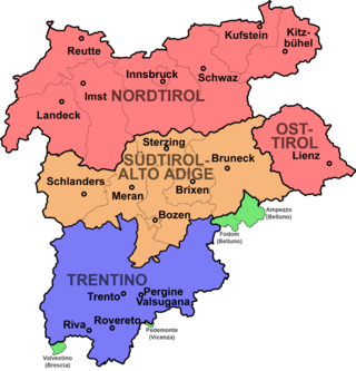
Tyrol is a historical region in the Alps of Northern Italy and western Austria. The area was historically the core of the County of Tyrol, part of the Holy Roman Empire, Austrian Empire and Austria-Hungary, from its formation in the 12th century until 1919. In 1919, following World War I and the dissolution of Austria-Hungary, it was divided into two modern administrative parts through the Treaty of Saint-Germain-en-Laye:

An alpine route or high alpine route is a trail or climbing route through difficult terrain in high mountains such as the Alps, sometimes with no obvious path. In the Alps, the various alpine clubs define and mark an alpine route, also called alpinweg or alpinwanderweg. More generally, the term is used for routes of crossing the Alps, such as Roman crossings and Napoleon crossing the Alps. It is also used to describe routes in other mountains with alpine conditions.
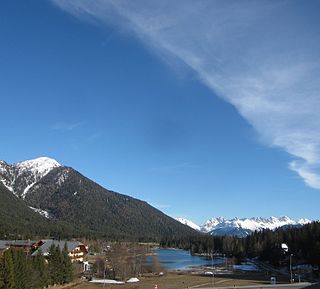
The Seefeld Saddle is a saddle and mountain pass, 1,185 m (AA), in the Northern Limestone Alps in the Austrian federal state of Tyrol. Two major transport routes run over it: the Seefelder Straße (B 177) and the Mittenwald Railway. On the Seefeld Plateau north of the saddle lies the village and ski resort of Seefeld in Tirol.
Monte Calisio, at 3,582 feet (1,092 m), is a mountain located in the North of Italy and surrounded by the suburbs of Trento and Civezzano: Martignano, Cognola, Villamontagna, Gardolo and Melta di Gardolo.

