
Union County is a county in the Commonwealth of Pennsylvania. As of the 2020 census, the population was 42,681. Its county seat is Lewisburg. The county was created on March 22, 1813, from part of Northumberland County. Its name is an allusion to the federal Union. Mifflinburg was established by legislation as the first county seat until it was moved to New Berlin in 1815. Lewisburg became county seat in 1855 and has remained so since. Union County comprises the Lewisburg, PA Micropolitan Statistical Area, which is also included in the Bloomsburg-Berwick-Sunbury, PA Combined Statistical Area.

Middleport is a borough in Schuylkill County, Pennsylvania, United States. The population was 363 at the time of the 2020 census.
Nuremberg is a census-designated place (CDP) that is located in Schuylkill and Luzerne counties, Pennsylvania, United States. The population was 434 at the time of the 2010 census.

Buffalo Township is a township in Union County, Pennsylvania, United States. The population was 3,536 at the 2020 census.

Kelly Township is a township in Union County, Pennsylvania, United States. The population was 3,993 at the 2020 census. The United States Penitentiary, Lewisburg is located in Kelly Township, and not in the nearby Borough of Lewisburg, whose post office serves most of the township.

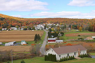
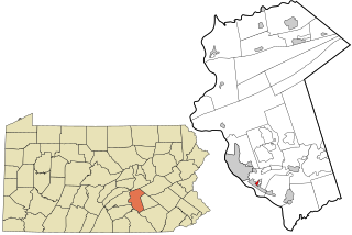
New Berlin is a borough in Union County, Pennsylvania, United States. The population was 791 at the 2020 census.

Reserve Township is a township in Allegheny County, Pennsylvania, United States. The population was 3,333 at the 2010 census.
Nunda is a village in the town of Nunda, Livingston County, New York, United States. The population of the village was 1,377 at the 2010 census, out of 3,064 in the entire town.
Lamar is a small, unincorporated community and census-designated place (CDP) in Aransas County, Texas, United States, 10 miles (16 km) north of Rockport and 40 miles (64 km) north of Corpus Christi. As of the 2010 census it had a population of 636. The community was named for Mirabeau B. Lamar, the second president of the Republic of Texas. This was a new CDP for the 2010 census.

Mount Aetna is a census-designated place in Tulpehocken Township, Berks County, Pennsylvania, United States. It is located along Pennsylvania Route 501 near the border of Lebanon County. The community is named after the active volcano, Mount Etna, in Sicily. As of the 2010 census, the population was 354 residents.

New Market is a census-designated place located in Fairview Township, York County in the state of Pennsylvania, United States. The community is located near the Susquehanna River in far northern York County, near the borough of New Cumberland, which is located in Cumberland County. As of the 2010 census, the population was 816 residents.

Weston is a census-designated place (CDP) in Black Creek Township, Luzerne County, Pennsylvania, United States. The population was 321 at the 2010 census.
Enhaut is an unincorporated community and census-designated place (CDP) located in Swatara Township, Dauphin County, Pennsylvania, United States. The community was formerly part of the census-designated place of Bressler-Enhaut-Oberlin, before splitting into three separate CDPs for the 2010 census. As of the 2010 census, the population in Enhaut was 1,007.

Atlas is a census-designated place located in Mount Carmel Township, Northumberland County in the state of Pennsylvania. The community is located very close to the borough of Mount Carmel along Pennsylvania Route 61. As of the 2010 census the population was 809 residents.
Kapp Heights is a census-designated place located in Point Township, Northumberland County in the state of Pennsylvania. The community is located very close to the borough of Northumberland along Pennsylvania Route 147, near the confluence of the West Branch Susquehanna River and Susquehanna Rivers. As of the 2010 census the population was 863 residents.

Grier City is a census-designated place located in Rush Township, Schuylkill County in the state of Pennsylvania, United States. Grier City was part of the Grier City-Park Crest CDP for the 2000 census, before splitting into two separate CDPs for the 2010 census, the other being Park Crest. The community is located off Interstate 81. As of the 2010 census, the population was 241 residents. As of the 2020 census, the population was 296 residents.
Muir is a census-designated place located in Porter Township, Schuylkill County in the state of Pennsylvania, United States. Muir was part of the Reinerton-Orwin-Muir CDP at the 2000 census before splitting into three individual CDPs for the 2010 census. The other communities, along with Muir are Reinerton and Orwin. The community is located near the borough of Tower City along U.S. Route 209. As of the 2010 census, the population was 451 residents.
Orwin is a census-designated place located in Porter Township, Schuylkill County in the state of Pennsylvania, United States. Orwin was part of the Reinerton-Orwin-Muir CDP at the 2000 census before splitting into three individual CDPs for the 2010 census. The other communities, along with Orwin are Reinerton and Muir. The community is located near the community of Muir along U.S. Route 209. As of the 2010 census, the population was 314 residents.
Park Crest is a census-designated place located in Rush Township in Schuylkill County in the state of Pennsylvania, United States. Park Crest was part of the Grier City-Park Crest CDP for the 2000 census, before splitting into two separate CDPs for the 2010 census, the other being Grier City. The community is located off Interstate 81. As of the 2010 census, the population was 542 residents.

Dalmatia is a census-designated place located in Lower Mahanoy Township, Northumberland County in the state of Pennsylvania. The community is located along Pennsylvania Route 147 in southwestern Northumberland County, along the Susquehanna River. As of the 2010 census the population was 488 residents.

