Virginia State Route 70

Last updated

Virginia 70.svg

State Route 70
VA 70 map.svg
Route information
Maintained by VDOT
Length11.88 mi [1] (19.12 km)
Existed1940–present
Tourist
routes
Virginia D6-V1.svg Virginia Byway
Major junctions
South endSecondary Tennessee 70.svg SR 70 near Kyles Ford, TN
North endUS 58.svg US 58 in Jonesville
Location
Counties Lee
Highway system
Virginia 69.svg SR 69 SR 71 Virginia 71.svg

State Route 70 (SR 70) is a primary state highway in Lee County, Virginia, running from the Tennessee state line to U.S. Route 58 in Jonesville. Its continuation in Tennessee, also numbered State Route 70, continues south to the North Carolina state line at North Carolina Highway 208.

Contents

Route description

View south at the north end of SR 70 at US 58 in Jonesville 2017-06-12 16 22 54 View south along Virginia State Route 70 (Trail of the Lonesome Pine) at U.S. Route 58 (Wilderness Road) in Jonseville, Lee County, Virginia.jpg
View south at the north end of SR 70 at US 58 in Jonesville

SR 70 begins at the Tennessee state line in the valley formed by Blackwater Creek. It follows that creek past Blackwater, but soon leaves it to ascend Powell Mountain, which it crosses at Hunter Gap. SR 70 comes down off that mountain and then rises again, crossing Wallen Ridge before descending again and crossing the Powell River on Sewell Bridge. From there it heads north across a relatively flat area, ending at US 58 in the eastern part of Jonesville. [2]

History

The road from Jonesville south via Blackwater to Tennessee was part of the Trail of the Lonesome Pine, an auto trail from Detroit to Florida. In 1924, a group of citizens from far western Virginia appeared before the State Highway Commission, asking them to take it over as a state highway. A member of the Tennessee Legislature stated that be was sure that it would be designated a state highway in Tennessee if Virginia took over their part. [3] The northernmost two miles (3 km) were added later in 1924 [4] as SR 1010, and a further 8 miles (13 km) were added in 1927. [5] SR 1010 was renumbered to SR 103 in the 1928 renumbering, and the final 3.5-mile (5.5 km) piece from Blackwater to Tennessee was added that year. [6]

In the 1933 renumbering, SR 103 south of Jonesville was combined with the remaining piece of SR 11, which ran from Jonesville northeast to Lebanon along present U.S. Route 58 Alternate (and its old alignments) and SR 71, to form State Route 64. (SR 11 had continued to Bluefield, West Virginia along US 19.) [7] In late 1940, most of SR 64 was renumbered as SR 70, running from Tennessee to St. Paul, to match Tennessee's SR 70. North of St. Paul, SR 64 replaced the former SR 70 (now SR 63), while SR 64 remained on its old alignment from St. Paul southeast to Dickensonville, and switched places with SR 71 to end at Hansonville. Additionally, while SR 64 had gone from Pennington Gap towards Big Stone Gap via Woodway, the new SR 70 replaced SR 66 via Dryden; the old SR 64 from Woodway towards Big Stone Gap became SR 65. [8]

US 58 Alt. was formed in the early 1950s, and replaced all of SR 70 east of Jonesville, truncating it to its current length. [9] In 1954, SR 70 became a secondary route, SR 798, over objections. [10] [11] It was added back to the primary system in 1962, after being reconstructed, including the building of a new bridge over the Powell River. [12]

Major intersections

The entire route is in Lee County.

Locationmi [1] kmDestinationsNotes
0.000.00Secondary Tennessee 70.svg SR 70 south Rogersville Tennessee state line
Jonesville 11.8819.12US 58.svg US 58 (Wilderness Road)
1.000 mi = 1.609 km; 1.000 km = 0.621 mi

Related Research Articles

U.S. Route 58 is an east–west U.S. Highway that runs for 508 miles (818 km) from U.S. Route 25E just northwest of Harrogate, Tennessee, to U.S. Route 60 in Virginia Beach, Virginia. Until 1996, when the Cumberland Gap Tunnel opened, US 58 ran only inside the commonwealth of Virginia. It was then extended southwest along a short piece of former US 25E, which no longer enters Virginia, to end at the new alignment in Tennessee.

Virginia State Route 5 State highway in Virginia, United States

State Route 5 runs between the independent cities of Richmond and Williamsburg in the U.S. state of Virginia. Between Charles City County and James City County, it crosses the Chickahominy River via the Judith Stewart Dresser Bridge, a fixed-span bridge which replaced historic Barrett's Ferry and the former drawbridge.

Virginia State Route 169

State Route 169 is a primary state highway in the U.S. state of Virginia. The state highway runs 7.41 miles (11.93 km) from Interstate 64 (I-64) and U.S. Route 60 to US 258 within the independent city of Hampton. SR 169 is a C-shaped route that connects the Hampton neighborhoods of Phoebus, Buckroe Beach, and Fox Hill.

U.S. Route 421 in Virginia

U.S. Route 421 (US 421) is a part of the U.S. Highway System that runs from Fort Fisher, North Carolina to Michigan City, Indiana. In Virginia, the U.S. Highway runs 69.23 miles (111.41 km) from the Tennessee state line between the twin cities of Bristol, Tennessee and Bristol, Virginia north and west to the Kentucky state line near St. Charles. Between its endpoints, US 421 has lengthy concurrencies with US 23 and US 58 during its course through Bristol, Weber City, Gate City, Duffield, and Pennington Gap in Southwest Virginia.

Virginia State Route 71

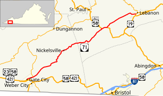
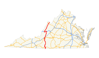
State Route 71 is a primary state highway in the southwest part of the U.S. state of Virginia. It runs from Gate City northeast to Lebanon, mostly through river valleys. Despite running more east–west than north–south, it is signed north–south; it parallels the similarly-oriented U.S. Route 11 and Interstate 81.

Virginia State Route 72

State Route 72 is a primary state highway in the southwest part of the U.S. state of Virginia. It runs from SR 71 in Gate City north to SR 65 at Fort Blackmore, northeast with SR 65 to Dungannon, and north via Coeburn to SR 83 near Clintwood.

Virginia State Route 75

State Route 75 is a primary state highway in the southwest part of the U.S. state of Virginia, running southwest from U.S. Route 11 and U.S. Route 58 Alternate in Abingdon to Tennessee's State Route 44.

Virginia State Route 67

State Route 67 is a primary state highway in the southwest part of the U.S. state of Virginia. It runs from State Route 80 near Honaker east to U.S. Route 460 at Raven, east concurrently with US 460 and U.S. Route 460 Business into downtown Richlands, and north to State Route 616 at Jewell Ridge on the Tazewell–Buchanan county line.

Virginia State Route 16

State Route 16 is a primary state highway in the southwest part of the U.S. state of Virginia. It runs from the North Carolina border at North Carolina Highway 16 north to the West Virginia border at West Virginia Route 16, passing through the towns of Troutdale, Marion, and Tazewell. Highway 16 is part of a three-state route 16 that connects the Charlotte region with northwestern West Virginia.

Virginia State Route 80

State Route 80 is a primary state highway in the southwest part of the U.S. state of Virginia. It runs from the Kentucky state line at Breaks Interstate Park east to U.S. Route 11 near Meadowview. Kentucky Route 80 and Missouri's Route 80 continue the number west to Matthews, Missouri.

U.S. Route 220 in Virginia

In the U.S. state of Virginia, U.S. Route 220 (US 220) is a major north-south state highway that extends from the North Carolina state line through Roanoke to the West Virginia state line. South of Roanoke, US 220 is a four-lane highway within the proposed Interstate 73 (I-73) corridor. US 220 narrows to two lanes north of Roanoke, connecting to I-64 near Clifton Forge and then paralleling the Appalachian Mountains north-northeasterly in the direction of Cumberland, Maryland.

Virginia State Route 13

State Route 13 is a primary state highway in the U.S. state of Virginia. Known as Old Buckingham Road, the state highway runs 24.08 miles (38.75 km) from U.S. Route 60 and SR 45 in Cumberland east to US 60 in Plain View. SR 13 parallels US 60 to the south through eastern Cumberland County and western Powhatan County and passes through the latter county's seat of Powhatan. The state highway is the only state-numbered highway in Virginia that shares a number with a U.S. Highway but does not form a state-numbered extension of that U.S. Highway. SR 13's number comes from being a segment of the original cross-state SR 13 in 1918; that highway included portions of modern US 60. In 1933, US 60 was shifted to its present corridor between Buena Vista and Richmond, replacing SR 13. Two years later, SR 13 was assigned to Old Buckingham Road when US 60 was moved to its present alignment from Cumberland to east of Powhatan.

References

  1. 1 2 3 "2005 Virginia Department of Transportation Jurisdiction Report - Daily Traffic Volume Estimates - Lee County" (PDF). (230  KiB)
  2. Google (August 7, 2014). "Virginia State Route 70" (Map). Google Maps . Google. Retrieved August 7, 2014.
  3. State Highway Commission of Virginia (January 8–9, 1924). Minutes of Meeting (PDF) (Report). Richmond, VA: Commonwealth of Virginia. pp. 3–4.
  4. State Highway Commission of Virginia (April 10–11, 1924). Minutes of Meeting (PDF) (Report). Richmond, VA: Commonwealth of Virginia. p. 6.
  5. State Highway Commission of Virginia (March 11, 1927). Minutes of Meeting (PDF) (Report). Richmond, VA: Commonwealth of Virginia. p. 7.
  6. State Highway Commission of Virginia (August 9–10, 1928). Minutes of Meeting (PDF) (Report). Richmond, VA: Commonwealth of Virginia. p. 12.
  7. Virginia Highways Project: VA 64
  8. State Highway Commission of Virginia (October 10, 1940). Minutes of Meeting (PDF) (Report). Richmond, VA: Commonwealth of Virginia. p. 12.
  9. Virginia Highways Project: US 58 ALT
  10. State Highway Commission of Virginia (July 20, 1954). Minutes of Meeting (PDF) (Report). Richmond, VA: Commonwealth of Virginia. p. 29.
  11. State Highway Commission of Virginia (August 3–5, 1954). Minutes of the Meeting of the State Highway Commission of Virginia: Conference at Mountain Lake and Inspection Trip in that Area (PDF) (Report). Mountain Lake, VA: Commonwealth of Virginia. p. 3.
  12. State Highway Commission of Virginia (June 21, 1962). Minutes of Meeting (PDF) (Report). Richmond, VA: Commonwealth of Virginia. p. 14.

Route map:

KML file (edithelp)
    KML is from Wikidata
    <  SR 109 Spurs of   SR 10
    1923–1928
    SR 1011  >
    <  SR 102 District 1 State Routes
    1928–1933
    SR 104  >