Related Research Articles
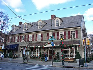
Chestnut Hill is a neighborhood in the Northwest Philadelphia section of Philadelphia, Pennsylvania. It is known for the high incomes of its residents and high real estate values, as well as its private schools.

Roxborough is a neighborhood in the Northwest section of the city of Philadelphia, Pennsylvania. It is bordered to the southwest, along the Schuylkill River, by the neighborhood of Manayunk, along the northeast by the Wissahickon Creek section of Fairmount Park, and to the southeast by the neighborhood of East Falls. Beyond Roxborough to the northwest is Montgomery County. Roxborough's ZIP code is 19128. Most of Roxborough is in Philadelphia's 21st Ward.

The Julia Reynolds Masterman Laboratory and Demonstration School is a middle and secondary school located in Philadelphia. It is a magnet school, ranked 10th in the nation, located in the Spring Garden neighborhood. Prior to 1958, the school building was used by the Philadelphia High School for Girls and the building was placed on the National Register of Historic Places under that name in 1986.

Germantown High School was a secondary school located in Philadelphia, Pennsylvania. Germantown High School graduated its final class on June 19, 2013 and closed its doors that week.
The Chicago High School for Agricultural Sciences (CHSAS) is a public 4–year magnet high school located in the Mount Greenwood neighborhood on the far south side of Chicago, Illinois, United States. The school is operated by the Chicago Public Schools district. CHSAS opened for the 1985–86 school year in August 1985. The school is located on a 72-acre (290,000 m2) campus, 40 acres (160,000 m2) of which are dedicated to a working farm, and the students commute from all across the city to CHSAS.

The Walnut Lane Bridge is a concrete arch bridge located in Northwest Philadelphia that connects the Germantown and Roxborough neighborhoods across the Wissahickon Creek in Fairmount Park. While drivers may cross the bridge too quickly to notice, the view from underneath the bridge has inspired many artists and writers, such as Christopher Morley. The design was copied from Pont Adolphe in Luxembourg.
The Science Leadership Academy is a magnet public high school in Philadelphia, Pennsylvania, which opened in September 2006. SLA is a partnership between The Franklin Institute and the School District of Philadelphia. SLA is a 1:1 project-based laptop school where all students and teachers use laptops as their primary learning tool.

Wissahickon is a neighborhood in the section of Lower Northwest Philadelphia in the state of Pennsylvania. Wissahickon is located adjacent to the neighborhoods of Roxborough and Manayunk, and it is bounded by the Wissahickon Valley Park, Ridge Avenue, Hermit Street, and Henry Avenue. The name of the neighborhood comes from the Lenni Lenape word wisameckham, for "catfish creek", a reference to the fish that were once plentiful in the Wissahickon Creek.
The Young Women's Leadership School at E. Washington Rhodes High School was a public secondary school for girls located at 3100 North 29th Street in Philadelphia, Pennsylvania, United States. The school was a part of the School District of Philadelphia.
Weavers Way Co-op is a member-owned consumers' cooperative in Philadelphia's West Mt. Airy section. Founded in 1973, Weavers Way Co-op was formed as a neighborhood buying club in a church basement. Since its incorporation, it has grown to more than 5,000 member households, with annual sales of nearly $20 million. After moving to its location at 559 Carpenter Lane, Weavers Way expanded, purchasing the adjacent building and consolidating the two buildings. Subsequent expansions included the purchase of two buildings across the street, which include a retail pet supply store, retail health and wellness store and offices. Weavers Way expanded again, adding a second, larger store in Chestnut Hill, at 8424 Germantown Ave, at the former Caruso's grocery store site, in 2010 and a health and beauty specialty store, also in Chestnut Hill, in 2013. For several years, Weavers Way also ran a third smaller store in the West Oak Lane section of Philadelphia, but that closed in September 2011. The Co-op rents warehouse space several miles away in the Nicetown section, in the SHARE food pantry complex. Two farm operations comprise 5.5 acres, one at Awbury Arboretum in Germantown and one on the grounds of Saul Agricultural High School in Roxborough. Weavers Way has participated in such events and organizations as Mt. Airy Day, Mt. Airy ArtJam, Mt. Airy YouthWorks, Mt. Airy Business Association, Mt. Airy USA (MAUSA), Mt. Airy Village Fair, Chestnut Hill's Fall for the Arts Festival and the XPoNential Music Fest.

George W. Nebinger Elementary School is a K–8 school located in the Bella Vista neighborhood of Philadelphia, Pennsylvania. It is a part of the School District of Philadelphia.
Fanny Jackson Coppin School, previously Federal Street School and then Andrew Jackson School, is a public K-8 school located in the Passyunk Square neighborhood of Philadelphia, Pennsylvania. It is a part of the School District of Philadelphia. The school was previously named for United States President Andrew Jackson before changing the name in 2021 to honor former Philadelphia teacher Fanny Jackson Coppin.

William M. Meredith School is a public K-8 school located in the Queen Village neighborhood of Philadelphia, Pennsylvania. It is a part of the School District of Philadelphia.
Strawberry Mansion High School is a public high school in the Strawberry Mansion section of Philadelphia. It is part of the School District of Philadelphia. It was previously named Strawberry Mansion Junior / Senior High School, and Strawberry Mansion Middle/High School.

Erdenheim Farm is a 450-acre (1.82 km2) working farm in Springfield and Whitemarsh Townships, Montgomery County, Pennsylvania, United States. Located just outside the Chestnut Hill section of Philadelphia, it is bordered by the Morris Arboretum to the east, Whitemarsh Valley Country Club to the south, Carson Valley School to the north, and Corson's Quarry to the west. The Wissahickon Creek flows through the farm and Stenton Avenue crosses it. All but 23 acres of the land is now protected from development by conservation easements.

Delaware Valley High School (DVHS) is a for-profit company and private school operating the Bucks Campus in Warminster Heights, a community in Warminster Township in Bucks County, Pennsylvania.
The Academies at Roxborough High School is a public high school in Philadelphia, Pennsylvania, operated by the School District of Philadelphia and servicing the Roxborough, Manayunk, Chestnut Hill, Wissahickon, Mt. Airy, and Germantown sections of Philadelphia.

Universal Audenried Charter High School , formerly Charles Y. Audenried High School, is a high school servicing the Grays Ferry area of Philadelphia. The school was originally located at the Charles Y. Audenried Junior High School but was rebuilt in 2008. It was previously directly operated by the School District of Philadelphia. It is still a part of the district's system, and some South Philadelphia residences are assigned to Audenried.
Lankenau Environmental Science Magnet High School is a district-run magnet high school in Upper Roxborough, Northwest Philadelphia. It is a part of the School District of Philadelphia. The school's Advanced Placement participation was 34 percent during the 2014 school year. The school has also received a Bronze recognition by U.S. News & World Report's list of Best U.S. High Schools from 2012 through 2014.
References
- ↑ "W.B. Saul High School of Agricultural Sciences Archived 2013-04-15 at the Wayback Machine ." Roxborough-Manayunk Patch. Retrieved on March 28, 2013.
- 1 2 3 4 5 6 7 Graham, Kristen A. "At Saul High, talented crop of students." Philadelphia Inquirer . October 22, 2012. Retrieved on March 28, 2013.
- ↑ "Our History." (Archive) W. B. Saul High School. Retrieved on March 28, 2013.