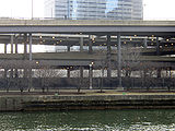
The Frederick G. Gardiner Expressway, commonly known as the Gardiner Expressway or simply the Gardiner, is a partially at grade and elevated municipal expressway in Toronto, Ontario, Canada. Running close to the shore of Lake Ontario, it extends from the foot of the Don Valley Parkway (DVP) in the east, just past the mouth of the Don River, to the junction of Highway 427 and the Queen Elizabeth Way (QEW) in the west, for a total length of 18.0 kilometres (11.2 mi). East of Dufferin Street to just east of the Don River, the roadway is elevated for a length of 6.8 kilometres (4.2 mi), unofficially making it the longest bridge in Ontario, as it runs above Lake Shore Boulevard east of Spadina Avenue. The Gardiner Expressway is wholly owned and operated by the City of Toronto.
The Don Valley Parkway (DVP) is a municipal freeway in Toronto, Ontario, Canada, which connects the Gardiner Expressway in downtown Toronto with Highway 401. North of Highway 401, it continues as Highway 404. The parkway runs through the parklands of the Don River valley, after which it is named. It has a maximum speed limit of 90 km/h (56 mph) for its entire length of 15.0 km (9.3 mi). It is six lanes for most of its length, with eight lanes north of York Mills Road and four lanes south of Eastern Avenue. As a municipal road, it is patrolled by the Toronto Police Service.

U.S. Route 41, also U.S. Highway 41 (US 41), is a major north–south United States Numbered Highway that runs from Miami, Florida, to the Upper Peninsula of Michigan. Until 1949, the part in southern Florida, from Naples to Miami, was US 94. The highway's southern terminus is in the Brickell neighborhood of Downtown Miami at an intersection with Brickell Avenue (US 1), and its northern terminus is east of Copper Harbor, Michigan, at a modest cul-de-sac near Fort Wilkins Historic State Park at the tip of the Keweenaw Peninsula. US 41 closely parallels Interstate 75 (I-75) from Naples, Florida, all the way through Georgia to Chattanooga, Tennessee.

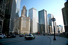
Michigan Avenue is a north-south street in Chicago that runs at 100 east on the Chicago grid. The northern end of the street is at Lake Shore Drive on the shore of Lake Michigan in the Gold Coast Historic District. The street's southern terminus is at Sibley Boulevard in the southern suburb of Dolton, but like many other Chicago streets, it exists in several disjointed segments.
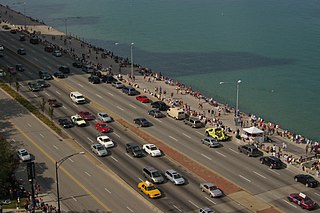
Lake Shore Drive is an expressway that runs alongside the shoreline of Lake Michigan, and adjacent to parkland and beaches, in Chicago. Except for the portion north of Foster Avenue, Lake Shore Drive is designated as part of U.S. Highway 41. A portion of the expressway on the Outer Drive Bridge and its bridge approaches is multilevel.

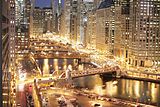
Downtown Chicago, Illinois, has some double-decked and a few triple-decked streets immediately north and south of the Main Branch and immediately east of the South Branch of the Chicago River. The most famous and longest of these is Wacker Drive, which replaced the South Water Street Market upon its 1926 completion. The resulting bi-level street has an upper-level riverfront boulevard, a lower-level roadway for commercial and through traffic, and a recreational walkway at water level.
Illinois Center is a mixed-use urban development in downtown Chicago, Illinois, USA, lying east of Michigan Avenue. It is notable in that the streets running through it have three levels. Elsewhere in Chicago, some streets have two levels, with the lower level for through traffic and service vehicles and the upper level for other local traffic. In Illinois Center, the lower level has been split, with a middle level for through traffic and a lower level for service vehicles.

Randolph Street is a street in Chicago. It runs east–west through the Chicago Loop, carrying westbound traffic west from Michigan Avenue across the Chicago River on the Randolph Street Bridge, interchanging with the Kennedy Expressway (I-90/I-94), and continuing west. It serves as the northern boundary of Grant Park and the Chicago Landmark Historic Michigan Boulevard District. Several large theaters, as well as city and state government buildings are on and adjacent to Randolph. Metra's Millennium Station is located under Randolph Street.

Columbus Drive is a north–south street in Chicago, Illinois, which bisects Grant Park. It is 300 East in Chicago's street numbering system. Its south end is an interchange with Lake Shore Drive at Soldier Field. After intersecting Illinois Street, it becomes Fairbanks Court and continues to the north, terminating at Chicago Avenue.

The Kichi Zībī Mīkan, formerly the Sir John A. Macdonald Parkway, and previously the Ottawa River Parkway, is a four-lane scenic parkway along the Ottawa River in Ottawa, Ontario, Canada. It runs from Carling Avenue near Connaught Avenue, to Booth Street at the Canadian War Museum and National Holocaust Monument. It is maintained by the National Capital Commission. The speed limit is 60 km/h (37 mph). Bicycles are allowed on the road and on a parallel recreational path along the parkway.

Interstate 95 (I-95) is part of the Interstate Highway System and runs from Miami, Florida, to the Canada–United States border near Houlton, Maine. In the US state of New York, I-95 extends 23.50 miles (37.82 km) from the George Washington Bridge in New York City to the Connecticut state line at Port Chester. The George Washington Bridge carries I-95 across the Hudson River from New Jersey into New York City. There, I-95 runs across Upper Manhattan on the Trans-Manhattan Expressway for 0.81 miles (1.30 km) through Washington Heights. It continues east across the Harlem River on the Alexander Hamilton Bridge and onto the Cross Bronx Expressway. In the Bronx, I-95 leaves the Cross Bronx at the Bruckner Interchange, joining the Bruckner Expressway to its end. North of the interchange with Pelham Parkway, it then continues northeast via the New England Thruway out of New York City into Westchester County and to the Connecticut state line, where I-95 continues on the Connecticut Turnpike.
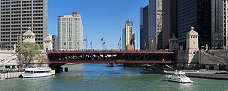
The DuSable Bridge is a bascule bridge that carries Michigan Avenue across the main stem of the Chicago River in downtown Chicago, Illinois, United States. The bridge was proposed in the early 20th century as part of a plan to link Grant Park (downtown) and Lincoln Park (uptown) with a grand boulevard. Construction of the bridge started in 1918, it opened to traffic in 1920, and decorative work was completed in 1928. The bridge provides passage for vehicles and pedestrians on two levels. An example of a fixed trunnion bascule bridge, it may be raised to allow tall ships and boats to pass underneath. The bridge is included in the Michigan–Wacker Historic District and has been designated as a Chicago Landmark.

New York State Route 27A (NY 27A) is a state highway between Massapequa in Nassau County and Oakdale in Suffolk County, on Long Island, New York, in the United States. Its two most prominent components are Merrick Road and Montauk Highway.

North Avenue is a major east–west street in Chicago, Illinois, and its western suburbs. Starting at St. Charles's eastern border with West Chicago, its name changes from Main Street to North Avenue, just east of the Kane/DuPage county line. From there, it travels straight east, carrying Illinois Route 64 until LaSalle Drive in Chicago. Illinois Route 64 then continues north onto LaSalle Drive for a very short distance until ending at U.S. Route 41, while North Avenue continues east for less than one-half mile, changing its name to North Boulevard at Clark Street, and then continuing until its termination in a cul-de-sac at 200 East, just west of Lake Shore Drive. From Illinois Route 43 to its east end, North Avenue is within the city limits of Chicago.

Ida B. Wells Drive is a major east–west street in downtown Chicago, Illinois, in the United States. It runs east from the Jane Byrne Interchange, where it meets Interstate 90 (I-90), I-94 and I-290. At Wells Street, Ida B. Wells Drive continues as a surface street past State Street and Michigan Avenue, until ending at Columbus Drive in Grant Park in front of the Buckingham Fountain. In 2018, the editorial board of The New York Times praised the Chicago City Council's renaming of the street to honor the journalist and civil rights activist Ida B. Wells.

Fullerton Avenue, known as Fullerton Parkway from its intersection with Halsted Street and Lincoln Avenue to its east end, is a major east–west street in Chicago and its western suburbs. Its west end is at Gary Avenue in Carol Stream. The road is split in many locations, usually because of freeways or railroads. Its east end is located at U.S. Route 41 in Chicago.

The Chicago Riverwalk is a multi-use public open space located on the south bank of the main branch of the Chicago River in Chicago, extending from Lake Michigan and Lake Shore Drive westward to Lake Street. The Chicago Riverwalk contains restaurants, bars, cafes, small parks, boat and kayak rentals, a Vietnam War memorial, and other amenities.
Marine Drive is the name for three major roadways in Greater Vancouver, British Columbia, Canada. The roads are known for running parallel to major bodies of water, with some sections being a major arterial road, while other serve local traffic. Marine Way is the name applied to a section of Marine Drive that was bypassed in the early 1980s.


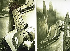 Two aerial views in 1926
 A side view, as seen from the Chicago River
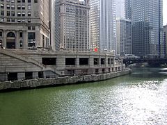 Wacker Drive in downtown Chicago
 A view of Wacker Drive and the Chicago River looking east from Merchandise Mart in February 2017.
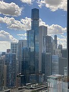 View of East Wacker skyscrapers from Lake Point Tower, July 2022