Wajay is a ward (consejo popular, "people's council") of the city of Havana, the capital of Cuba, belonging to the municipal borough of Boyeros. In 2011, it had a population of 47,954.
Its origins go back to the period bequeathed by the aborigines of the Cacique Habaguanex region, when the Indians who populated the island nicknamed the humid lands full of large trees, streams and gaps with the expressions: Guajay> Yubajay> Jubajay, territories that will form part after Havana.
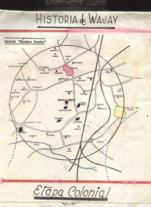
This first settlement developed as a result of agrarian and peasant growth in an extensive wetland. In the first moments of the Spanish colonization it was granted the property to Martín Recio de Oquendo on June 29, 1575, which was henceforth the corral of "Sacalohondo".
In 1688, Diego Avelino de Compostela founded the "curatos del campo" and the parishes of Santiago el Mayor and Lady of Candelaria. Its initial writing with letter -w- is not defined until year 1762, when the taking of Havana by the English -June 6- and the influence becoming of the Anglo-Saxon language marks its new and later name "Wajay".
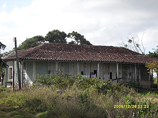
Starting in 1764, the church of the village was completed on the land Don Dionisio de Berroa, a relative of Don Esteban, who had left the lands of the “Sacalohondo” corral to his children. Times when the "town" had: 49 guano houses, 20 built of bricks and stones, clay and tiles; some tobacco shops, a store and a bakery distributed in three streets with ditches in which riveruelas ran that ended in small spillways.
Its international renown is felt when the famous German naturalist Alexander von Humboldt, (1767-1835) researcher who studied the climate in "the Indies" -Cuba- and the marine currents of Peru or the Humboldt Current, cited in his studies to the climate of Havana!, in which he placed the Wajay: “5 maritime leagues from the city, on the plain that was 28 toises above sea level, the partial average temperature in December 1795 was 18.8 degrees and in 1800 it ranged between 13.8 and 18.9 ”.
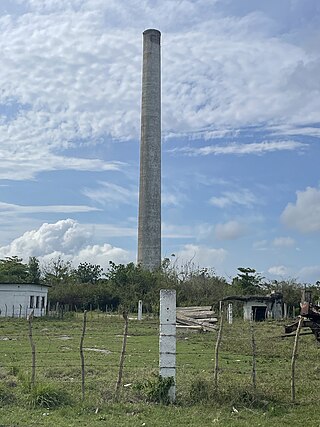
In 1860, the neighborhood already had a primary school, a sugar mill, two roof tiles, 4 coffee plantations, 12 quarries, 16 pastures and 116 work sites where different crops were harvested, among which stood out: legumes, coffee, chayotes, yucca and island taro.
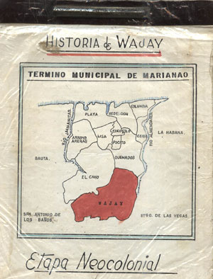
The Havana City Council, the founding of Marianao as an independent municipality, dates back to 1878, although since 1870 the demands to obtain said proclamation were raised to the Governor General of the Island. This was achieved after the end of the Ten Years' War when several municipalities emerged under the protection of the new Municipal Law.
Neocolonial Republic
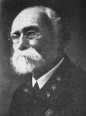
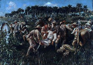
At the beginning of the 20th century, (1902) Neocolonial Republic, the Wajay became part of the political-administrative jurisdiction of the Municipality of Marianao. The conflicts of the Estrada Palma government produce the first clash between the natives of the town of what was later, the civil war, according to Enrique Loynaz del Castillo, a patriot who led the fighting of: Babiney-Colorado and the Wajay on 14 September 1906. Event in which the town gates felt the rifle butt, and the houses were taken by the guard, the blood ran, a child died and General Loynaz del Castillo was wounded with a machete blow to the head.
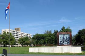
The Spanish Guard Barracks, current Paquito Gonzáles School, formerly the town's Basic High School, was inaugurated on September 26, 1942, an installation that was also the town's first Public Primary School No. 29, named “Elisa Godinez de Batista”. A lady who encouraged the construction of the recreation work -Parque de Wajay- at its doors (1943), a space in which the traditional "Coffee Party" is celebrated today. In 1943 it had a population of 4,535, that grew in the last decades of the 20th century.[citation needed]
Coffee party
After the triumph of the Revolution, the town became a section of the Boyeros region. In the 1960s some 100 million coffee bushes were planted throughout the area. Stage in which the plantation of the grain was generalized, building facilities for pulping, drying coffee. Program that compromised the agricultural extension of the entire region that surrounded Havana.
Cradle of coffee in Cuba whose tradition is celebrated every year with the name of Fiesta del Café, one of the oldest traditions of the Capital, a great carnival with parades of floats and comparsas as well as the traditional Colada de Café Gigante colada that starts the festivities every November.
In the last presentation Casa de la Cultura Wajay (2013) the first historian of the town Gerardo Gandarilla Gómez (deceased) stated: “It has been confirmed that Don José Gelabert, introduced in the country some seeds of the grain from the coffee plantations of Haiti, in 1748, appearing the farm "Las Columnas", the main entrance to the town (east highway) as the "First coffee plantation in Cuba". This leaves without effect the generalized in popular memory as the "La Aurora" coffee plantation located in an old house located on the Morales farm, south highway of the town of Murgas, Santa Cecilia.
The ward is divided into the quarters (repartos) of Wajay (centre), Abel Santamaría, Fontanar, El Chico, El Morado, INVAF and Santa Cecilia.[citation needed]
La Habana Province, formerly known as Ciudad de La Habana Province, is a province of Cuba that includes the territory of the city of Havana, the Republic's capital. The province's territory is the seat of the superior organs of the state and its provincial administration.
Carlos Juan Finlay was a Cuban epidemiologist recognized as a pioneer in the research of yellow fever, determining that it was transmitted through mosquitoes Aedes aegypti.
Máximo Gómez y Báez was a Dominican Generalissimo in Cuba's War of Independence (1895–1898). He was known for his controversial scorched-earth policy, which entailed dynamiting passenger trains and torching the Spanish loyalists' property and sugar plantations—including many owned by Americans. He greatly increased the efficacy of the attacks by torturing and killing not only Spanish soldiers, but also Spanish sympathizers and especially Cubans loyal to Spain. By the time the Spanish–American War broke out in April 1898, the rebellion was virtually defeated in most of Western Cuba, with only a few operating pockets in the center and the east. He refused to join forces with the Spanish in fighting off the United States, and he retired to the Quinta de los Molinos, a luxury villa outside of Havana after the war's end formerly used by captains generals as summer residence.
Ignacio Agramonte y Loynaz was a Cuban revolutionary, who played an important part in the Ten Years' War (1868–1878).
The Almendares River is a river that runs for 47 km in the western part of Cuba. It originates from the east of Tapaste and flows north-west into the Straits of Florida. The river acts as a water supply for Havana.
Rock and roll music was introduced in Cuba in the late 1950s, with many Cuban artists of the time covering American songs translated into Spanish, as was occurring in Mexico at the same time. "The Batista police never looked kindly on Rock and Roll, and much less after the screening of films like Rebel Without a Cause and The Bad Seed, among others. After 1959, Rock and Roll followed the same path, although artists like Argentinean Luis Aguile emerged."
Santiago de las Vegas is a ward of Boyeros, a municipality of Havana, Cuba, located 20 km (12 mi) south of the city center. As of 2012, the population was 32,958. The Cuban government maintains an agricultural experiment station as well as a meteorology center in the city.
Artemisa is a municipality and city in Cuba, formerly part of La Habana Province. According to a law approved by the Cuban National Assembly in August 2010, Artemisa became the capital city of the newly formed Artemisa Province, which comprises eight municipalities of the former La Habana Province and three from Pinar del Río. It has an area of 642.0 square kilometers and a population of over 85,000 inhabitants (2017).
Boyeros is one of the 15 municipalities or boroughs in the city of Havana, Cuba. The municipality was created in 1976, and amalgamated the town of Santiago de Las Vegas. It lies on the south-west side of the city and includes José Martí International Airport.
Encrucijada is a municipality and town in the Villa Clara Province of Cuba. It was founded in 1850 and established as a municipality in 1910.
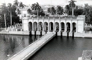
The Acueducto de Albear is the name of a water supply system of the city of Havana, Cuba, built in the 19th century by Francisco de Albear.
The following is a timeline of the history of Havana, Cuba.
The following is a timeline of the history of the city of Camagüey, Cuba.
Calabazar is a ward of the city of Havana, the capital of Cuba, belonging to the municipal borough of Boyeros. In 2011, it had a population of 20,069.
Colegio Nacional de Arquitectos de Cuba (C.N.A.C.) is a Cuban national institution based in Havana, that grew out of El Colegio de Arquitectos de La Habana.
The Battle of San Pedro was a battle of the Cuban War of Independence that took place on December 7, 1896 within the vicinity of the farm of the same name. The battle occurred near the town of Punta Brava on the outskirts of Marianao, La Habana Province.
Juan Evangelista Delgado González was a Cuban colonel who participated during the Cuban War of Independence. He was known for retrieving the bodies of Antonio Maceo Grajales and Panchito Gómez Toro during the Battle of San Pedro where both were killed in the battle.
Luis Arcos Bergnes also known as Carmita is a small town and a ward in Camajuani, Villa Clara, Cuba. With a population of 2,279 it is considered a village.
Enrique Loynaz del Castillo was a Dominican-born Cuban general and independence activist of the late 19th-century and early 20th-century. He was known for his service in the Cuban War of Independence, participating in the battles of Mal Tiempo and Paso de las Damas.
This page is based on this Wikipedia article Text is available under the CC BY-SA 4.0 license; additional terms may apply. Images, videos and audio are available under their respective licenses.


