Warnford

Last updated

Warnford
Warnford.jpg
Hampshire UK location map.svg
Red pog.svg
Warnford
Location within Hampshire
Population220  [1]
OS grid reference SU624231
Civil parish
  • Warnford
District
Shire county
Region
Country England
Sovereign state United Kingdom
Post town Southampton
Postcode district SO32
Dialling code 01730
Police Hampshire and Isle of Wight
Fire Hampshire and Isle of Wight
Ambulance South Central
UK Parliament
List of places
UK
England
Hampshire
51°00′14″N1°06′35″W / 51.003803°N 1.109848°W / 51.003803; -1.109848

Warnford is a village and civil parish in the City of Winchester district of Hampshire, England. The parish covers 1283 hectares [2] (3170 acres). The village lies on the A32 in the upper valley of the River Meon between West Meon and Exton. The population in 2019 was estimated at 220. [3] The village is rural in character, with most of the buildings along River Lane, Lippen Lane and Hayden Lane.

Contents

The George and Falcon pub and hotel, which is grade II listed and dates to the 18th century [4] [5] is located on the A32 near the centre of the village.

The Church of Our Lady, located in Warnford Park to the south of the village, is Grade 1 listed. [6]

The village hall [7] is located in Lippen Lane close to the centre of the village and was converted from a farm shop, having been earlier a pig farm laboratory. It was given to the village in 1998 by the owner of the Warnford Estate. The hall has a single room which can accommodate up to 100 people and is available for hire by the hour.

Warnford Playground in Lippen Lane was given by the family of R.P. Chester in his memory in 1978 for the benefit of parishioners. It is managed by a charitable trust. It is open to the public, but there is very limited parking and no facilities such as toilets.

History

There is evidence in the form of barrows or burial mounds of occupation from early times. The barrow and associated Saxon boundary bank at Sheepbridge is registered as a Scheduled Monument. Both are referred to in a land charter dating from the time of King Aethelstan. The Domesday book records Warnford and also Upwarnford, which is believed to have covered the northern part of the parish.

The Church of Our Lady is of Saxon origin but was rebuilt in the 12th century [8] and contains relics of an earlier Saxon church. The ruins of the 13th century St. John's or King John's House, also Grade 1 listed, are behind the church. [9] The church and St John's House are accessible via a public footpath from the A32. Warnford Park is itself Grade II listed as a park and garden, but is not open to the public except on Sundays in February when a "snowdrop walk" is opened up in aid of the church, with the permission of the landowner. The park was the site of the manor house, renamed "Belmont" in the 19th century and demolished in the 1950s. It was requisitioned by the War Office in World War II and never reoccupied by the owners afterwards.

The parish contains a considerable number of other listed buildings, including the farmhouse, well house and granary at Bere Farm, Abbey House (formerly the rectory), North Lodge and the adjacent gateway into Warnford Park, Papermill Cottage and Riversdown House. None of these is open to the public. The hall at Riversdown house dates to 1327 and was probably originally around 12 by 9 meters. [10]

Air crash

On 4 April 1944 a Royal Air Force, Airspeed Horsa I (LG999) was taking part in a training exercise out of RAF Keevil. The glider was being towed by a Short Stirling (LJ842) and during the training the Stirling struck trees. This resulted in the Airspeed Horsa I crashing in the park, killing the two pilots and all 24 paratroopers. To date, the crash remains the second deadliest involving a glider. The Stirling aircraft later crashed near Romsey, killing all six crew. [11] [12] [13]

Geography

River Meon at Warnford Playground River Meon at Warnford Playground.jpg
River Meon at Warnford Playground

The parish is roughly triangular and includes the village itself and about a mile of the Meon Valley. The centre of the village in the more recent past was the crossroads by the George & Falcon, but the demolition of buildings for road widening, fast traffic on the A32 and closure of the village shops has shifted the focus to the main area of housing along River Lane and Lippen Lane. There are also houses in Hayden Lane and Wheely Down Road, with outlying farms and houses at Wheely Farm, Riversdown, Bere and Lower Peake. From the crossroads by the pub Hayden Lane climbs a spur of the downs, rising to Old Winchester Hill and onwards to Clanfield. Just west of the village Wheely Down Road branches from the A32, heading up a side valley and then climbing onto the Hampshire Downs plateau on its way to Winchester.

The River Meon flows through the village. In summer the section between West Meon and Warnford is often dry, but there are major springs at Moorhen Trout Fishery and just below it at Warnford Upper Pond, so the river through the village is always in water. There is on the ground evidence of an extensive system of channels fed from sluices in Warnford Upper Pond and higher up the valley at Sheepbridge which fed water to meadows on the west side of the valley. There is a very attractive section through the playground. The river flows under the A32 into the park and feeds a lake, originally the pond for a paper mill close to the A32 at the junction with Peake New Road.

Farmland on Warnford Chalk Plateau Warnford Chalk Plateau.jpg
Farmland on Warnford Chalk Plateau

The land rises to an extensive area of chalk plateau to the north and west, extending from Bere Farm across Pinks Hill to the side valley that carries Wheely Down Road. There are beautiful views across the valley from the public footpaths which climb Pinks Hill. The Beacon Hill National Nature Reserve and SSSI is at the western end of the parish, a chalk hill some 201 metres (659 ft) high flanked by numerous steep-sided dry valleys. Beacon Hill is accessible via the Monarch's Way long-distance footpath which crosses the valley in Warnford. The village was by-passed by the former Meon Valley Railway (now the "Meon Valley Trail" footpath and cycleway) [14] which runs down the east side of the valley.

To the south and east of the village Hayden Lane crosses the old railway line and climbs a spur of the chalk downs to the Old Winchester Hill National Nature Reserve, which is just outside the eastern end of the parish . The South Downs Way links these two nature reserves and shares short sections of the Monarch's Way either side of the parish. The route across the valley has been contentious and was the subject of public inquiries in 2004 and 2006. Although a footpath route via Beacon Hill Lane and Peake New Road was approved after the second inquiry, the inspector's decision was overturned in the High Court [15] and this route has not been pursued further by Hampshire County Council. Ordnance Survey maps now show a southerly route past Beacon Hill via Exton, implemented as a temporary measure but now in place for the foreseeable future.

Business, Transport and Land Use

Watercress beds in Warnford WarnfordWatercress.jpg
Watercress beds in Warnford

The primary land use in the parish is agriculture. Major landowners are Gawthorpe Estates Ltd (Warnford Estate); MJI Farming Ltd (Abbey House Estate) and F R Horn (Beaconsfield Farm). Small businesses in the parish include Huxley Golf Ltd (The Old Grain Store); Moorhen Trout Fishery (Alton Road); Larksfield Nursery (Hayden Lane); Earle Brothers Motorcycles (The Long Barn) and Charles Normandale (Wheely Down Forge).

There are watercress beds owned by Vitacress Ltd at three places in the valley but two of these are currently out of use.

Public transport is limited. Stagecoach Bus 67 makes a morning trip on schooldays only to collect students heading to Petersfield. There is also a community bus operated by the Meon Valley Community Bus Association which makes regular weekly trips to Petersfield, to Hedge End and to Fareham. The timetable is available on the Warnford village website (see below).

Further information on the village is available on the Warnford village website. [16]

Related Research Articles

<span class="mw-page-title-main">Wickham, Hampshire</span> Village in Hampshire, England

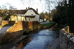
Wickham is a large village in the civil parish of Wickham and Knowle, in the Winchester district, in the county of Hampshire, England. It is about 3 miles north of Fareham. In 2021 it had a population of 2173. At the 2001 census, it the parish a population of 4,816, falling to 4,299 at the 2011 Census.

<span class="mw-page-title-main">South Downs Way</span> Long-distance footpath in the south of England

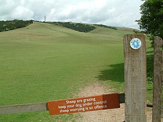
The South Downs Way is a long distance footpath and bridleway running along the South Downs in southern England. It is one of 16 National Trails in England and Wales. The trail runs for 160 km (100 mi) from Winchester in Hampshire to Eastbourne in East Sussex, with about 4,150 m (13,620 ft) of ascent and descent.

<span class="mw-page-title-main">Exton, Hampshire</span> Human settlement in England

Exton is a small village and civil parish in the City of Winchester district of Hampshire, England. The village lies in the South Downs National Park, on the west bank of the River Meon, immediately to the north of Corhampton. It is located two miles north of Droxford and five miles north-east of Bishop's Waltham. Its name first appears in 940 as East Seaxnatune, meaning "farmstead of the East Saxons".

<span class="mw-page-title-main">Monarch's Way</span> Long-distance footpath in England

The Monarch's Way is a 625-mile (1,006 km) long-distance footpath in England that approximates the escape route taken by King Charles II in 1651 after being defeated in the Battle of Worcester. It runs from Worcester via Bristol and Yeovil to Shoreham, West Sussex.

<span class="mw-page-title-main">Fair Oak</span> Human settlement in England

Fair Oak is a large village to the east of the town of Eastleigh in Hampshire, England. Together with the village of Horton Heath, which lies to the south, it is part of the civil parish of Fair Oak and Horton Heath.

<span class="mw-page-title-main">Clanfield, Hampshire</span> Village and civil parish in Hampshire, England

Clanfield is a village and civil parish in the south-east of the East Hampshire district of Hampshire, England. It is situated 2.4 miles north of Horndean, 12 mi (19 km) north of Portsmouth and 6 mi (10 km) south of Petersfield. It sits to the west of the main A3 road, just north of where the A3(M) (Motorway) ends.

<span class="mw-page-title-main">West Meon</span> Human settlement in England

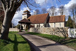
West Meon is a village and civil parish in Hampshire, England, with a population of 749 people at the 2011 census.

<span class="mw-page-title-main">Droxford</span> Human settlement in Hampshire, United Kingdom

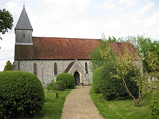
Droxford is a village in Hampshire, England.

The following are lists of recreational walks in Hampshire, England:

<span class="mw-page-title-main">Beacon Hill, Warnford</span>

Beacon Hill, Warnford is a 46.4-hectare (115-acre) biological Site of Special Scientific Interest west of Warnford in Hampshire. It is a Nature Conservation Review site, and an area of 40.1 hectares is a national nature reserve. There is a round barrow cemetery dating to the Late Neolithic or Bronze Age on the hill, and this is a scheduled monument.

<span class="mw-page-title-main">Meonstoke</span> Village in Hampshire, England

Meonstoke is a village and former civil parish, now in the parish of Corhampton and Meonstoke, in the Winchester district, in the county of Hampshire, England. It is in the Meon Valley where it cuts through the Middle Chalk of the South Downs, Old Winchester Hill is at the edge of the parish to the east. In 1931 the parish had a population of 439.

<span class="mw-page-title-main">East Tisted</span> Human settlement in England

East Tisted is a village and civil parish in the East Hampshire district of Hampshire, England. It is 4.8 miles (7.7 km) south of Alton on the A32 road.

<span class="mw-page-title-main">East Hampshire AONB</span>

East Hampshire Area of Outstanding Natural Beauty (AONB) in England was designated in 1962. The designation was revoked in March 2010, together with the neighbouring Sussex Downs AONB, upon the establishment of the South Downs National Park. The southern part of the area is mainly rolling chalk downland used for farming that is a westward extension of the Sussex Downs. The north and east includes steep wooded hills and heathland.

<span class="mw-page-title-main">Chilcomb</span> Human settlement in England

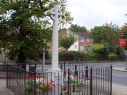
Chilcomb is a small village and civil parish in the English county of Hampshire 3 miles (4.8 km) east of Winchester and includes the South Downs Way long-distance footpath.

<span class="mw-page-title-main">Curdridge</span> Human settlement in England

Curdridge is a village and civil parish within the City of Winchester district of Hampshire, England. The parish also contains the similarly named village of Curbridge. The village has a small school. The parish is located eight miles to the east of Southampton and had a population of 1,292 people in 473 households in the 2001 census, the population increasing to 1,398 in 520 households at the 2011 Census. Curdridge is also known for its annual Curdridge Country Show that takes place in a field off Reading Room Lane

<span class="mw-page-title-main">Privett</span> Human settlement in England

Privett is a small village and former civil parish, now in the parish of Froxfield and Privett, in the East Hampshire district of Hampshire, England. It is 5 miles (8.0 km) northwest of Petersfield, just off the A272 road. Its principal feature is Holy Trinity Church, designed by Arthur Blomfield and built at the expense of local landowner, businessman and M.P. William Nicholson. Nicholson was also responsible for building in the village a number of dwellings for workers on his Basing Park estate. In 1931 the parish had a population of 172.

This is a list of places of interest in the ceremonial county of Hampshire, England. See List of places in Hampshire for a list of settlements in the county.

<span class="mw-page-title-main">Knowle, Hampshire</span> Human settlement in England

Knowle is a village with mainly 21st century shops and businesses in the civil parish of Wickham and Knowle, in the Winchester district of Hampshire, England that sits high on the left bank of the Meon between the Southampton and Portsmouth conurbations. It is in the south of the parish of Wickham and Knowle in which it ranks in population about 25% behind Wickham. Its nearest town is Fareham, adjoining an inlet of Portsmouth Harbour approximately 3 miles (4.8 km) south-east.

The Winchester-East Meon Anticline is one of a series of parallel east–west trending folds in the Cretaceous chalk of Hampshire. It lies at the western end of the South Downs, immediately to the north of the Hampshire Basin and south-east of Salisbury Plain.

<span class="mw-page-title-main">Froxfield and Privett</span> Human settlement in England

Froxfield and Privett is a civil parish in East Hampshire, England, about 3 miles (5 km) northwest of Petersfield. The settlements in the parish are the villages of Froxfield Green, Privett and High Cross, and several hamlets including Bailey Green, Filmore Hill, Stoner Hill and Warren Corner. The population of the parish taken at the 2021 census was 929.

References

  1. "Parish Headcounts, Area: Warnford CP". Neighbourhood Statistics. Office for National Statistics. 2001. Archived from the original on 12 June 2011. Retrieved 11 March 2008.
  2. "Standard Area Measurement for Parishes in England and Wales". Office for National Statistics.
  3. "citypopulation.de".
  4. George & Falcon website (retrieved 02/05/2021)
  5. "THE GEORGE AND FALCON INN, Warnford - 1350306 | Historic England". historicengland.org.uk. Retrieved 14 September 2023.
  6. Stuff, Good. "Church of Our Lady, Warnford, Hampshire". britishlistedbuildings.co.uk.
  7. "Warnford village hall - Warnford Village, Warnford, Southampton". www.hugofox.com.
  8. "CHURCH OF OUR LADY, Warnford - 1296978 | Historic England". historicengland.org.uk.
  9. "Warnford". Hampshire Treasures Vol. 1 pp.305-311. Hampshire County Council. Retrieved 11 March 2008.
  10. Roberts, Edward; Crook, John (2003). "True Aisled and Aisle-Derivative Halls in Hampshire". Hampshire Houses 1250-1700: Their Dating and Development. Hampshire County Council. p. 11. ISBN   1859756336.
  11. "20th Century History of Warnford - Warnford Village - Warnford Village, Warnford, Southampton". www.hugofox.com.
  12. "Hampshire Aircraft Crashes and Accidents". www.hampshireairfields.co.uk.
  13. "Sgt Henry Thomas Joel".
  14. "Hampshire County Council - Meon Valley Trail".
  15. The Queen on the application of MJI (Farming) Ltd v the Secretary of State for the Environment, Food and Rural Affairs (CO/5061/2008)
  16. "Warnford Village, Warnford, Southampton". www.hugofox.com.