
Delta County is a county located in the U.S. state of Colorado. As of the 2020 census, the population was 31,196. The county seat is Delta.

Paonia is a statutory town in Delta County, Colorado, United States. The population was 1,447 at the 2020 census.

Carmel Valley is an American Viticultural Area (AVA) located in Monterey County, California, southeast of Carmel-by-the-Sea and it is one of the ten AVAs in the county. Approximately 100 miles (161 km) south of San Francisco, the AVA was recognized by the Bureau of Alcohol, Tobacco and Firearms (ATF), Treasury on January 13, 1983 after reviewing the petition submitted by Mr. David Armanasco, General Manager of Dumey Vineyard, located in Carmel, to propose a viticultural area named “Carmel Valley.”

The Grand Mesa is a large mesa in western Colorado in the United States. It is the largest flat-topped mountain in the world. It has an area of about 500 square miles (1,300 km2) and stretches for about 40 miles (60 km) east of Grand Junction between the Colorado River and the Gunnison River, its tributary to the south. The north side of the mesa is drained largely by Plateau Creek, a smaller tributary of the Colorado. The west side is drained largely by Kannah Creek, which is received to the west by the lower Gunnison River. The mesa rises about 6,000 feet (1,800 m) above the surrounding river valleys, including the Grand Valley to the west, reaching an elevation of about 11,000 feet (3,400 m). Much of the mesa is within Grand Mesa National Forest. Over 300 lakes, including many reservoirs created and used for drinking and irrigation water, are scattered along the top of the formation. The Grand Mesa is flat in some areas, but quite rugged in others.
Chalone identifies the first American Viticultural Area (AVA) established in Monterey County, California straddling its border with San Benito County where it is the second established AVA. Chalone viticultural area is located in the Gabilan Mountains east of Soledad. It was recognized by the Bureau of Alcohol, Tobacco and Firearms (ATF) effective on July 14, 1982 after reviewing the petition submitted by the Gavilan Vineyards, Inc. to establish a viticultural area in Monterey and San Benito counties to be named "The Pinnacles." The area encompasses 8,640 acres (14 sq mi) and the proposed name was recognition of the nearby Chalone peaks.

Willamette Valley is an American Viticultural Area (AVA) which lies in the Willamette Valley of Oregon. The AVA is the wine growing region which encompasses the drainage basin of the Willamette River. It stretches from the Columbia River in the north to just south of Eugene in the south, where the Willamette Valley ends; and from the Oregon Coast Range in the west to the Cascade Mountains in the east. At 5,360 square miles, it is the largest AVA in the state, and contains most of the state's wineries; approximately 908 as of 2021.

Red Mountain is an American Viticultural Area (AVA) that encompasses the local region surrounding Red Mountain in Benton County, Washington. The viticultural area was formally recognized on June 11, 2001 by the Bureau of Alcohol, Tobacco and Firearms (ATF), Treasury after reviewing the petition submitted by Lorne Jacobson of Hedges Cellars to establish an area known as "Red Mountain." It lies entirely within the Yakima Valley and vast Columbia Valley appellations and is the smallest AVA in the state at only 4,040 acres (6.31 sq mi) in area and lies between Benton City and the City of West Richland. The area has more than 2,225 acres (900 ha) under cultivation of primarily red varietals including Cabernet Sauvignon, Merlot, Sangiovese, Cabernet Franc and Syrah. The reputation of the area's wines has brought Red Mountain worldwide attention and acclaim for producing some of the most desired Washington State vintage wines.

Puget Sound is an American Viticultural Area (AVA) in northwest portion of Washington state encompassing Clallam, Island, Jefferson, King, Kitsap, Mason, Pierce, San Juan, Skagit, Snohomish, Thurston and Whatcom Counties. It is the only Washington AVA located west of the Cascade Mountains.

Temecula Valley is an American Viticultural Area (AVA) in the Temecula Valley, located in southwestern Riverside County, California against the eastern slopes of the Santa Ana Mountains. It was initially established by the Bureau of Alcohol, Tobacco and Firearms (ATF), Treasury as "Temecula" on October 23, 1984 based on submitted petitions from by the Rancho Califomia/Temecula Winegrowers Association and Callaway Vineyard and Winery, Temecula, California in 1982. It was renamed "Temecula Valley" by the Alcohol and Tobacco Tax and Trade Bureau (TTB) in 2004, approving the 2001 petition by Temecula Valley Winegrowers Association. The petition stated the name change would provide a more accurate description of the Temecula geography and greater clarity as to its location for wine consumers and the public. The petition did not request any change to the established AVA boundaries. This was the first American Viticultural Area to change its name after the initial approval. Temecula Valley encompasses 33,000 acres (52 sq mi) and 5,000 acres (8 sq mi) is located in a "protected" area referred to as the Citrus/Vineyard Zone. This area is generally located in and around the Rancho California Road area with Riverside County. County guidelines strictly enforce the number of acres needed to build a winery, lodging and other limited housing and commercial ventures.

Santa Cruz Mountains AVA is an American Viticultural Area (AVA) centered on the Santa Cruz Mountains. Its territory spans three California counties, Santa Clara, Santa Cruz and San Mateo and was established January 4, 1982 by the Bureau of Alcohol, Tobacco and Firearms (ATF), Treasury. Santa Cruz Mountains AVA was among the first AVA to be defined by its mountainous topography. Based on elevation, it largely follows the fog line along the coast, extending down to 800 feet (240 m) on the eastern slope toward San Francisco Bay, 400 feet (120 m) on the western slope to the Pacific Ocean and extending along the ridge crest line at 3,000 feet (910 m) elevation plus.

Sierra Foothills is a vast American Viticultural Area (AVA) encompassing the foothill "belt" of the Sierra Nevada in north-central California, United States. It was established on December 18, 1987 by the Bureau of Alcohol, Tobacco and Firearms (ATF), Treasury after evaluating the petition filed by the Sierra Foothills Winery Association of Somerset, California for the establishment of a "Sierra Foothills" viticultural area in portions of Yuba, Nevada, Placer, El Dorado, Amador, Calaveras, Tuolumne and Mariposa Counties. Wine grapes were introduced to the area in the nineteenth century during the California Gold Rush. Over 280 vineyards/wineries are located within its boundaries.
The Chiles Valley is an American Viticultural Area (AVA) located in Napa County, California and a sub-region within Napa Valley AVA. It was established as California's 81st AVA by the Bureau of Alcohol, Tobacco and Firearms (ATF) on April 19, 1999 after the ATF received the petition from Mr. Volker Eisele, owner of the Volker Eisele Vineyard and Winery proposing a new viticultural area in Napa County to be known as "Chiles Valley District".

Edna Valley is an American Viticultural Area (AVA) located in San Luis Obispo (SLO) County, California encompassing the rural town of Edna which is 9 miles (14 km) southeast of the county seat San Luis Obispo and north of the small coastal town Arroyo Grande. It was established by the Bureau of Alcohol, Tobacco and Firearms (ATF) as the county's first AVA within California’s multi-county Central Coast AVA effective May 12, 1982. It became an sub-appellation of the county’s newest San Luis Obispo Coast viticultural area since April 2022. The valley is diagonally flanked by Lake Lopez to the south and Islay Hill to the north. The elongated valley extends along a northwest-southeast axis bordered to the west by the Santa Lucia Mountains and surrounded by volcanic mountains and characterized by black humus and clay-rich soils. With moderate sunshine, cool maritime fog, and rich oceanic and volcanic soils, the Edna Valley appellation has California's longest growing season. The valley is kept cool by breezes from the Pacific Ocean and morning fog. The extended growing season allows complex flavors to develop in the grapes.

Colorado wine refers to wine made from grapes grown in the U.S. state of Colorado. Most of Colorado's vineyards are located on the western slope of the Rocky Mountains, though an increasing number of wineries are located along the Front Range.

El Dorado is an American Viticultural Area (AVA) located in El Dorado County, California, east of the state’s capital, Sacramento and centered around the county seat of Placerville. It was established on November 14, 1983 by the Bureau of Alcohol, Tobacco, Firearms and Explosives (ATF), Treasury after approving the submitted petition from the El Dorado Wine Grape Growers Association of Camino, California applying to establish a viticultural area named "El Dorado.” The area includes parts of El Dorado County on the north border by the Middle Fork American River and on the south by the South Fork of the Cosumnes River. El Dorado viticultural area lies within the vast 4,062 square miles Sierra Foothills viticultural area, one of the largest appellations in California, which extends about 170 miles (274 km) through portions of Yuba, Nevada, Placer, El Dorado, Amador, Calaveras, Tuolumne and Mariposa Counties. The El Dorado viticultural area encompasses 1,093,120 acres (1,708 sq mi) which entirely includes Fair Play and a small portion of northeastern California Shenandoah Valley AVAs.
North Yuba is an American Viticultural Area (AVA) located in Yuba County, California, United States about 70 miles (113 km) north of Sacramento. It was established on August 30, 1985 by the Bureau of Alcohol, Tobacco, Firearms and Explosives (ATF), Treasury after approving the submitted petition by Karl Werner and James R. Bryant, officers of Renaissance Vineyard and Winery, Inc. in Oregon House. They petitioned ATF for the establishment of a viticultural area to be named "North Yuba.”
Lake County wine is an appellation that designates wine made from grapes grown mostly in Lake County, California. The region is located north of Napa County and east of Mendocino County. Although each region within Lake County has unique viticultural attributes, many are influenced by Clear Lake, the largest inland body of water in California.

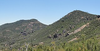
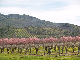
Grand Valley is an American Viticultural Area (AVA) within Mesa County, Colorado located in a high-altitude river valley surrounding the county seat of Grand Junction and stretching 24 miles (39 km) east-west between the municipalities of Palisade and Fruita. It lies approximately 200 miles (320 km) west-southwest of Denver along Interstate 70. The river valley encompasses 75,990 acres (118.73 sq mi), with an average elevation between 4,000 and 5,000 feet (1,200–1,500 m) above sea level and is defined by an irrigated agricultural area served by canals in the Grand Valley of the Colorado River. Grand Valley AVA was established by the Bureau of Alcohol, Tobacco and Firearms (ATF) on December 26, 1991, upon the petition submitted by Mr. James Seewald of Vintage Colorado Cellars Winery, and was the first viticultural area registered in Colorado. In 2001, the smaller West Elks AVA, located southeast of Grand Valley, became the state's second federally-designated AVA.

The West Elk Loop Scenic and Historic Byway is a 205-mile (330 km) National Forest Scenic Byway and Colorado Scenic and Historic Byway located in Delta, Garfield, Gunnison, Montrose, and Pitkin counties Colorado, USA. The byway reaches its zenith at Kebler Pass, elevation 10,007 feet (3,050 m), between Crested Butte and Paonia.

Monterey County wine is a appellation that designates wine made from grapes grown in Monterey County, California which lies entirely within the expansive multi-county Central Coast viticultural area. County names in the United States automatically qualify as legal appellations of origin for wine produced from grapes grown in that county and do not require registration with the Alcohol and Tobacco Tax and Trade Bureau (TTB). TTB was created in January 2003, when the Bureau of Alcohol, Tobacco and Firearms, or ATF, was extensively reorganized under the provisions of the Homeland Security Act of 2002.

