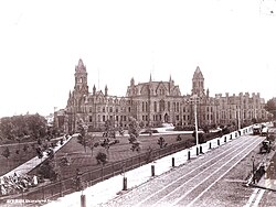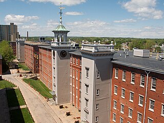
Lowell National Historical Park is a National Historical Park of the United States located in Lowell, Massachusetts. Established in 1978 a few years after Lowell Heritage State Park, it is operated by the National Park Service and comprises a group of different sites in and around the city of Lowell related to the era of textile manufacturing in the city during the Industrial Revolution. In 2019, the park was included as Massachusetts' representative in the America the Beautiful Quarters series.
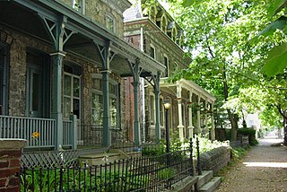
Powelton Village is a neighborhood of mostly Victorian, mostly twin homes in the West Philadelphia section of the United States city of Philadelphia, Pennsylvania. It is a national historic district that is part of University City. Powelton Village extends north from Market Street to Spring Garden Street, east to 32nd Street, west to 40th and Spring Garden Streets, and to 44th and Market Streets.
A streetcar suburb is a residential community whose growth and development was strongly shaped by the use of streetcar lines as a primary means of transportation. Such suburbs developed in the United States in the years before the automobile, when the introduction of the electric trolley or streetcar allowed the nation’s burgeoning middle class to move beyond the central city’s borders. Early suburbs were served by horsecars, but by the late 19th century cable cars and electric streetcars, or trams, were used, allowing residences to be built farther away from the urban core of a city. Streetcar suburbs, usually called additions or extensions at the time, were the forerunner of today's suburbs in the United States and Canada. San Francisco's Western Addition is one of the best examples of streetcar suburbs before westward and southward expansion occurred.

University City is the easternmost portion of West Philadelphia, encompassing several Philadelphia universities. It is situated directly across the Schuylkill River from Center City.

Cedar Park is a neighborhood of Philadelphia, Pennsylvania, United States. Located in the larger West Philadelphia district, it stretches north to Larchwood Ave., south to Kingsessing Ave., east to 46th Street, and west to 52nd Street.
Kirkwood is a national historic designated neighborhood on the east side of Atlanta, Georgia, United States. It is a historic streetcar suburb situated entirely in DeKalb County, bordered by the neighborhoods of Lake Claire, East Lake, Edgewood, and Oakhurst. Kirkwood is bound on the north by DeKalb Avenue, on the south by Memorial Drive and Interstate 20, on the west by Montgomery Street, and on the east by 1st Ave. A large part of the neighborhood is listed on the National Register of Historic Places as Kirkwood Historic District.

West Philadelphia, nicknamed West Philly, is a section of the city of Philadelphia. Alhough there are no officially defined boundaries, it is generally considered to reach from the western shore of the Schuylkill River, to City Avenue to the northwest, Cobbs Creek to the southwest, and the SEPTA Media/Wawa Line to the south. An alternate definition includes all city land west of the Schuylkill; this would also include Southwest Philadelphia and its neighborhoods. The eastern side of West Philadelphia is also known as University City.
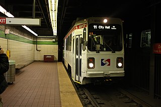
The SEPTA subway–surface trolley lines are a collection of five SEPTA trolley lines that operate on street-level tracks in West Philadelphia and Delaware County, Pennsylvania, and also underneath Market Street in Philadelphia's Center City. The lines, Routes 10, 11, 13, 34, and 36, collectively operate on about 39.6 miles (63.7 km) of route.
Spruce Hill is a neighborhood in the University City section of West Philadelphia, Pennsylvania, United States. It is situated between 40th and 46th streets and stretches from Market Street south to Woodland Avenue.

The Fort Smith Trolley Museum is a streetcar and railroad museum in Fort Smith, in the U.S. state of Arkansas, which includes an operating heritage streetcar line. The museum opened in 1985, and operation of its streetcar line began in 1991. Four vehicles in its collection, a streetcar and three steam locomotives, are listed on the National Register of Historic Places (NRHP). The now approximately three-quarters-mile-long (1.2 km) streetcar line also passes four NRHP-listed sites, including the Fort Smith National Historic Site, the Fort Smith National Cemetery, the West Garrison Avenue Historic District and the 1907 Atkinson-Williams Warehouse Building, which now houses the Fort Smith Museum of History.

Woodland Terrace is a street name and a small neighborhood of Eric Laird twin mansions in the West Philadelphia section of Philadelphia, Pennsylvania, United States. It was listed as a historic district on the National Register of Historic Places on March 16, 1972. The street runs from Baltimore Avenue to Woodland Avenue between 40th and 41st streets.

Fairlawn is a working class and middle class residential neighborhood in southeast Washington, D.C., United States. It is bounded by Interstate 295, Pennsylvania Avenue SE, Minnesota Avenue SE, Naylor Road SE, and Good Hope Road SE.

Dilworth is a neighborhood of Charlotte, Mecklenburg County, North Carolina, United States. The neighborhood was Charlotte's first streetcar suburb and was established by Edward Dilworth Latta in the 1890s on 250 acres (1 km²) southwest of the original city limits. It included the Joseph Forsyth Johnson designed Latta Park. Planned largely with a grid pattern similar to the city's original four wards, Dilworth was initially designated the Eighth Ward.
Elizabeth takes its name from Elizabeth College, a small Lutheran women's college founded in 1897 on the present-day site of Presbyterian Hospital. The community began in 1891 when a streetcar was established along East Trade Street to the area, making it the second oldest streetcar suburb in Charlotte. Elizabeth began to develop rapidly after 1902, when a trolley line was completed, and was annexed in 1907. Home of Independence Park, the first public park in the city, Elizabeth became one of the most fashionable residential areas in Charlotte in its early days. In 2006 Elizabeth had a population of 3,908.
The Kountze Place neighborhood of Omaha, Nebraska is a historically significant community on the city's north end. Today the neighborhood is home to several buildings and homes listed on the National Register of Historic Places. It is located between North 16th Avenue on the east to North 30th Street on the west; Locust Street on the south to Pratt Street on the north. Kountze Place was annexed into Omaha in 1887. The neighborhood was built as a suburban middle and upper middle class enclave for doctors, lawyers, successful businessmen and other professional workers.

There are nine historic districts in Meridian, Mississippi. Each of these districts is listed on the National Register of Historic Places. One district, Meridian Downtown Historic District, is a combination of two older districts, Meridian Urban Center Historic District and Union Station Historic District. Many architectural styles are present in the districts, most from the late 19th century and early 20th century, including Queen Anne, Colonial Revival, Italianate, Art Deco, Late Victorian, and Bungalow.
Isaac Pursell was a Philadelphia, Pennsylvania-based architect.

Fort Hill is a 0.4 square mile neighborhood and historic district of Roxbury, in Boston, Massachusetts. The approximate boundaries of Fort Hill are Malcolm X Boulevard on the north, Washington Street on the southeast, and Columbus Avenue on the southwest.

Girard Avenue is a major commercial and residential street in Philadelphia, Pennsylvania. For most of its length it runs east–west, but at Frankford Avenue it makes a 135-degree turn north. Parts of the road are signed as U.S. Route 13 and U.S. Route 30.

The Georgetown Car Barn, historically known as the Capital Traction Company Union Station, is a building in the Georgetown neighborhood of Washington, D.C., in the United States. Designed by the architect Waddy Butler Wood, it was built between 1895 and 1897 by the Capital Traction Company as a union terminal for several Washington and Virginia streetcar lines. The adjacent Exorcist steps, later named after their appearance in William Friedkin's 1973 horror film The Exorcist, were built during the initial construction to connect M Street with Prospect Street.