National Register of Historic Places listings in Perry County, Pennsylvania

Last updated

Location of Perry County in Pennsylvania Map of Pennsylvania highlighting Perry County.svg
Location of Perry County in Pennsylvania

This is a list of the National Register of Historic Places listings in Perry County, Pennsylvania.

Contents

This is intended to be a complete list of the properties and districts on the National Register of Historic Places in Perry County, Pennsylvania, United States. The locations of National Register properties and districts for which the latitude and longitude coordinates are included below, may be seen in a map. [1]

There are 23 properties and districts listed on the National Register in the county.


    This National Park Service list is complete through NPS recent listings posted December 15, 2023. [2]

Map all coordinates using: OpenStreetMap

Current listings

[3] Name on the RegisterImageDate listed [4] Location City or townDescription
1 Adairs Covered Bridge
Adairs Covered Bridge Adairs Bridge Perry Co.JPG
Adairs Covered Bridge
August 25, 1980
(#80003594)
East of Andersonburg on Legislative Route 50009
40°21′02″N77°25′27″W / 40.3506°N 77.4242°W / 40.3506; -77.4242 (Adairs Covered Bridge)
Southwest Madison Township
2 Bistline Covered Bridge
Bistline Covered Bridge BISTLINE COVERED BRIDGE.jpg
Bistline Covered Bridge
August 25, 1980
(#80003591)
South of Andersonburg on Legislative Route 50008
40°20′02″N77°28′14″W / 40.3339°N 77.4706°W / 40.3339; -77.4706 (Bistline Covered Bridge)
Southwest Madison Township
3 Book's Covered Bridge
Book's Covered Bridge Books Bridge 1.JPG
Book's Covered Bridge
August 25, 1980
(#80003592)
Southwest of Blain on Legislative Route 50004
40°19′28″N77°31′29″W / 40.3244°N 77.5247°W / 40.3244; -77.5247 (Book's Covered Bridge)
Jackson Township
4 Bower Homestead Farm August 6, 2021
(#100006784)
1790 Conococheague Rd.
40°19′47″N77°32′20″W / 40.3296°N 77.5390°W / 40.3296; -77.5390 (Bower Homestead Farm)
Blain
5 Bridge in Newport Borough
Bridge in Newport Borough Newport Boro Bridge.JPG
Bridge in Newport Borough
June 22, 1988
(#88000854)
Legislative Route 34 over Little Buffalo Creek
40°28′27″N77°07′48″W / 40.4742°N 77.13°W / 40.4742; -77.13 (Bridge in Newport Borough)
Newport and Oliver Township
6 Clark's Ferry Tavern
Clark's Ferry Tavern Clark's Ferry Tavern, Duncannon, PA - Market Street view.jpg
Clark's Ferry Tavern
February 18, 2021
(#100006148)
603 North Market Street
40°23′47″N77°01′30″W / 40.3965°N 77.0250°W / 40.3965; -77.0250 (Clark's Ferry Tavern)
Duncannon
7 Dellville Covered Bridge
Dellville Covered Bridge DELLVILLE COVERED BRIDGE.jpg
Dellville Covered Bridge
August 25, 1980
(#80003593)
Township 456
40°21′49″N77°07′00″W / 40.363611°N 77.116667°W / 40.363611; -77.116667 (Dellville Covered Bridge)
Wheatfield Township
8 Dunbar-Creigh House
Dunbar-Creigh House Dunbar Creigh.JPG
Dunbar-Creigh House
June 27, 1980
(#80003595)
Water Street
40°20′30″N77°18′25″W / 40.341667°N 77.306944°W / 40.341667; -77.306944 (Dunbar-Creigh House)
Landisburg
9 Fleisher Covered Bridge
Fleisher Covered Bridge Fleishers Bridge 1.JPG
Fleisher Covered Bridge
August 25, 1980
(#80003601)
Northwest of Newport on Township 477
40°29′22″N77°09′31″W / 40.489444°N 77.158611°W / 40.489444; -77.158611 (Fleisher Covered Bridge)
Oliver Township
10 Kochendefer Covered Bridge
Kochendefer Covered Bridge Kochenderfer Bridge 1.JPG
Kochendefer Covered Bridge
August 25, 1980
(#80003602)
Southeast of Saville on Township 332
40°25′27″N77°23′15″W / 40.424167°N 77.3875°W / 40.424167; -77.3875 (Kochendefer Covered Bridge)
Saville Township
11 Little Buffalo Historic District
Little Buffalo Historic District LITTLE BUFFALO HISTORIC DISTRICTY.jpg
Little Buffalo Historic District
April 3, 1978
(#78002440)
Southwest of Newport off Pennsylvania Route 34
40°27′19″N77°10′13″W / 40.455278°N 77.170278°W / 40.455278; -77.170278 (Little Buffalo Historic District)
Centre and Juniata Townships
12 Israel and Samuel Lupfer Tannery Site and House
Israel and Samuel Lupfer Tannery Site and House Lupfer house.jpg
Israel and Samuel Lupfer Tannery Site and House
May 30, 2003
(#03000493)
Black Hollow Road
40°16′54″N77°32′02″W / 40.281778°N 77.533778°W / 40.281778; -77.533778 (Israel and Samuel Lupfer Tannery Site and House)
Jackson and Toboyne Townships
13 Millersburg Ferry
Millersburg Ferry Millersburg Ferry.jpg
Millersburg Ferry
August 2, 2006
(#06000663)
Over the Susquehanna River between Millersburg and Buffalo Township
40°32′39″N76°58′25″W / 40.544167°N 76.973611°W / 40.544167; -76.973611 (Millersburg Ferry)
Buffalo Township Extends into Millersburg in Dauphin County
14 Mt. Pleasant Covered Bridge
Mt. Pleasant Covered Bridge Mt Pleasant Bridge 1.JPG
Mt. Pleasant Covered Bridge
August 25, 1980
(#80003599)
East of New Germantown on Township 304
40°18′54″N77°32′44″W / 40.315°N 77.545556°W / 40.315; -77.545556 (Mt. Pleasant Covered Bridge)
Jackson Township
15 New Germantown Covered Bridge
New Germantown Covered Bridge New Germantown Bridge.JPG
New Germantown Covered Bridge
August 25, 1980
(#80003600)
South of New Germantown on Township 302
40°18′24″N77°34′06″W / 40.306667°N 77.568333°W / 40.306667; -77.568333 (New Germantown Covered Bridge)
Jackson Township
16 Newport Historic District
Newport Historic District Newport Boro HD.JPG
Newport Historic District
March 12, 1999
(#99000321)
Roughly bounded by Fickes Lane, Oliver Street, Front Street, Little Buffalo Run, Bloomfield Avenue, and Sixth Street
40°28′39″N77°07′58″W / 40.4775°N 77.132778°W / 40.4775; -77.132778 (Newport Historic District)
Newport and Oliver Township
17 O'Donel House and Farm
O'Donel House and Farm ODonel House.JPG
O'Donel House and Farm
July 17, 1986
(#86001687)
West of New Germantown on Pennsylvania Route 274
40°16′53″N77°37′19″W / 40.281389°N 77.621944°W / 40.281389; -77.621944 (O'Donel House and Farm)
Toboyne Township
18 Perry County Courthouse
Perry County Courthouse Perry Co PA Courthouse.JPG
Perry County Courthouse
February 24, 1975
(#75001659)
Center Square
40°25′12″N77°11′15″W / 40.42°N 77.1875°W / 40.42; -77.1875 (Perry County Courthouse)
Bloomfield
19 Red Covered Bridge
Red Covered Bridge RED COVERED BRIDGE.jpg
Red Covered Bridge
August 25, 1980
(#80003597)
East of Millerstown on Legislative Route 50023
40°33′58″N77°00′14″W / 40.566056°N 77.003944°W / 40.566056; -77.003944 (Red Covered Bridge)
Liverpool Township
20 Rice Covered Bridge
Rice Covered Bridge Rice Bridge Perry Co 1.JPG
Rice Covered Bridge
August 25, 1980
(#80003596)
South of Landisburg on Legislative Route 50023
40°20′09″N77°18′34″W / 40.335833°N 77.309444°W / 40.335833; -77.309444 (Rice Covered Bridge)
Tyrone Township
21 Rockville Bridge
Rockville Bridge Rockville Bridge PA.jpg
Rockville Bridge
August 15, 1975
(#75001640)
0.5 miles south of central Marysville over the Susquehanna River
40°19′59″N76°54′42″W / 40.333056°N 76.911667°W / 40.333056; -76.911667 (Rockville Bridge)
Marysville Extends into Dauphin County
22 Saville Covered Bridge
Saville Covered Bridge Saville PA C Bridge 2.JPG
Saville Covered Bridge
August 25, 1980
(#80003603)
Legislative Route 50037
40°26′17″N77°23′47″W / 40.438056°N 77.396389°W / 40.438056; -77.396389 (Saville Covered Bridge)
Saville Township
23 Waggoner Covered Bridge
Waggoner Covered Bridge Waggoners Bridge.JPG
Waggoner Covered Bridge
August 25, 1980
(#80003598)
West of Loysville on Township 579
40°21′34″N77°22′23″W / 40.359444°N 77.373056°W / 40.359444; -77.373056 (Waggoner Covered Bridge)
Northeast Madison Township

See also

Related Research Articles

<span class="mw-page-title-main">National Register of Historic Places listings in Perry County, Alabama</span>

This is a list of the National Register of Historic Places listings in Perry County, Alabama.

<span class="mw-page-title-main">National Register of Historic Places listings in Berks County, Pennsylvania</span>

This is a list of the National Register of Historic Places listings in Berks County, Pennsylvania.

<span class="mw-page-title-main">National Register of Historic Places listings in Butler County, Pennsylvania</span>

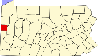
This is a list of the National Register of Historic Places listings in Butler County, Pennsylvania.

<span class="mw-page-title-main">National Register of Historic Places listings in Clarion County, Pennsylvania</span>

This is a list of the National Register of Historic Places listings in Clarion County, Pennsylvania.

<span class="mw-page-title-main">National Register of Historic Places listings in Clearfield County, Pennsylvania</span>

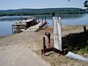
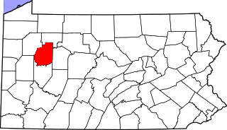
This is a list of the National Register of Historic Places listings in Clearfield County, Pennsylvania.

<span class="mw-page-title-main">National Register of Historic Places listings in Crawford County, Pennsylvania</span>

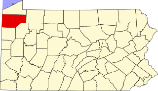
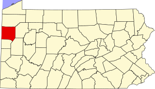
This is a list of the National Register of Historic Places listings in Crawford County, Pennsylvania.

<span class="mw-page-title-main">National Register of Historic Places listings in Cumberland County, Pennsylvania</span>

This is a list of the National Register of Historic Places listings in Cumberland County, Pennsylvania.

<span class="mw-page-title-main">National Register of Historic Places listings in Clinton County, Pennsylvania</span>

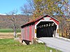
This is a list of the National Register of Historic Places listings in Clinton County, Pennsylvania.

<span class="mw-page-title-main">National Register of Historic Places listings in Fulton County, Pennsylvania</span>

This is a list of the National Register of Historic Places listings in Fulton County, Pennsylvania.

<span class="mw-page-title-main">National Register of Historic Places listings in Indiana County, Pennsylvania</span>

This is a list of the National Register of Historic Places listings in Indiana County, Pennsylvania.

<span class="mw-page-title-main">National Register of Historic Places listings in Jefferson County, Pennsylvania</span>

This is a list of the National Register of Historic Places listings in Jefferson County, Pennsylvania.

<span class="mw-page-title-main">National Register of Historic Places listings in Lawrence County, Pennsylvania</span>

This is a list of the National Register of Historic Places listings in Lawrence County, Pennsylvania.

<span class="mw-page-title-main">National Register of Historic Places listings in Lebanon County, Pennsylvania</span>

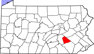
This is a list of the National Register of Historic Places listings in Lebanon County, Pennsylvania.

<span class="mw-page-title-main">National Register of Historic Places listings in Luzerne County, Pennsylvania</span>

This is a list of the National Register of Historic Places listings in Luzerne County, Pennsylvania.

<span class="mw-page-title-main">National Register of Historic Places listings in Mercer County, Pennsylvania</span>

This is a list of the National Register of Historic Places listings in Mercer County, Pennsylvania.

<span class="mw-page-title-main">National Register of Historic Places listings in Mifflin County, Pennsylvania</span>

This is a list of the National Register of Historic Places listings in Mifflin County, Pennsylvania.

<span class="mw-page-title-main">National Register of Historic Places listings in Northumberland County, Pennsylvania</span>

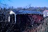
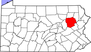
This is a list of the National Register of Historic Places listings in Northumberland County, Pennsylvania.

<span class="mw-page-title-main">National Register of Historic Places listings in Montour County, Pennsylvania</span>

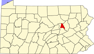
This is a list of the National Register of Historic Places listings in Montour County, Pennsylvania.

<span class="mw-page-title-main">National Register of Historic Places listings in Wayne County, Pennsylvania</span>

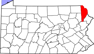
This is a list of the National Register of Historic Places listings in Wayne County, Pennsylvania.

<span class="mw-page-title-main">National Register of Historic Places listings in Perry County, Missouri</span>

This is a list of the National Register of Historic Places listings in Perry County, Missouri.

References

  1. The latitude and longitude information provided in this table was derived originally from the National Register Information System, which has been found to be fairly accurate for about 99% of listings. Some locations in this table may have been corrected to current GPS standards.
  2. National Park Service, United States Department of the Interior, "National Register of Historic Places: Weekly List Actions", retrieved December 15, 2023.
  3. Numbers represent an alphabetical ordering by significant words. Various colorings, defined here, differentiate National Historic Landmarks and historic districts from other NRHP buildings, structures, sites or objects.
  4. The eight-digit number below each date is the number assigned to each location in the National Register Information System database, which can be viewed by clicking the number.