Green Park, Pennsylvania

Last updated

An 1877 map of Green Park 1877PaMap-Right-150r.png
An 1877 map of Green Park

Green Park, an unincorporated village located in northeastern Tyrone Township, Perry County, Pennsylvania, United States, sits at the intersection of state routes 233 (Green Park Road) and 274 (Shermans Valley Road). The name was given to a local land tract by James Baxter in the late 1700s and made popular as an unofficial moniker for mid- to late-1800s picnic and camp meeting grounds (called Stambaugh's Woods, which lasted until 1896) located at the upper end of Stambaugh Farm Run. The town serves as Perry County's midpoint between the Conococheague Mountain in the west and the Susquehanna River to the east.

Contents

Given its central location, connection to a once-thriving wheelwright industry, historic one-room schoolhouse, and the West Perry (formerly Green Park Union) School District main campus, Green Park is unofficially nicknamed Perry County's "Hub of Education."[ citation needed ]

Places of interest

A Civil War-era farmhouse in Green Park Civil War-Era Farmhouse, Green Park, PA.jpg
A Civil War-era farmhouse in Green Park

Notable landmarks within the historic environs of Green Park include West Perry High School (formerly Green Park Union High School) and West Perry Middle School (formerly Green Park Elementary School), the Elliottsburg/Green Park Post Office, Stone House Farm & Inn (owned by Hempfield Behavioral Health), Kingdom Grounds Cafe coffee house and bakery, and the Perry Mennonite Reception Center. Places of interest include Bernheisel’s Mill, an 18th-century cemetery on the site of the former Limestone Presbyterian Church, [1] and the Green Park School House. [2] Agriculture comprises the principal industry, with eight commercial dairy, beef, hog, or grain farms operating in the community.

Municipal limits

Green Park comprises the northeastern corner of Tyrone Township. It is bisected from north to south by Pennsylvania Route 233 (Green Park Road) and east to west by Pennsylvania Route 274 (Shermans Valley Road). It is bordered on the east by the Tyrone Township-Spring Township line, the west by the village limits of Loysville, the north by the top of Limestone Ridge, and the south by Stonehouse Road. The main waterways include Montour Creek and Stambaugh Farm Run.

History

18th century

Alexander Roddy, who later built the initial grist mill in Perry County, Pennsylvania, was the first pioneer to live in what is now Green Park. He built a cabin of poles in the early 1750s by a spring on what later became the Stambaugh's Woods picnic and camp meeting grounds (now part of Green Pastures Farms). He was soon driven out with other squatters in the area due to pressure from local Indians. After the 1754 Treaty of Albany transferred lands in central Pennsylvania, including Perry County, from the Six Nations of the Iroquois Confederacy to John and Richard Penn Sr., Roddy returned, but to a new location.

In 1766, the Limestone Presbyterian Church, also known as the Lower Church or Sam Fisher's Church, was constructed at the bottom of Limestone Ridge on Dum Road in Green Park. It was abandoned in the early 1800s.

The western side of Green Park sits on a 530-acre tract warranted originally to Ludwig Laird in 1755, and surveyed to Henry Shoemaker in 1814. The eastern part lies on a tract of 50 acres warranted to Alexander Sanderson, who transferred it to John Henry Barnheisel (Bernheisel) on February 2, 1755. Soon thereafter, James Baxter warranted property east of Bernheisel's in the present location of West Perry High School, and named the tract "Green Park."

19th century

Around 1857, Judge Martin and John Mootzer opened a store and post office in the center of the village (today the intersection of Routes 233 and 274). They were succeeded in the business by Frank Mortimer, George Ernest, William B. Keck, W.W. McClure, Samuel Stambaugh, George Bernheisel, William Hoobaugh, and Edgar A. Stambaugh (the establishment being known as Grange Store Company).

The first Green Park school emerged in 1815. Several log schools and brick ones were built over next 70 years, but all fell victim to fire. The historic one-room schoolhouse now standing on Green Park Road, maintained by the Historical Society of Perry County [3] since 1969, operated from circa 1886 to 1954. [2] The Green Park Union School District closed the one-room school after opening a new high school in Green Park and converting the Landisburg High School into an elementary school. The historic school building was totally refurbished for the Perry County bicentennial in 2020 and includes original desks and teaching materials. The school bell, cast by the Rheem & Brothers foundry in Green Park, can be heard during open houses held each summer. [3]

In 1820, Green Park was one of the nine sites proposed for the Perry County seat. No houses were built in the village center until William Reed erected one in 1834.

John Henry Bernheisel opened a sawmill on his 330-acre farm circa 1790s; in 1832, his son Jacob (1801–1871) sold the sawmill to his brother Solomon (1808–1889). By 1835, Solomon had constructed a 3.5-story brick mill that processed hulled clover seed and ground sumac, a citrus-flavored spice, and a separate fulling mill and carding mill. The brick mill building still stands today, located on Pennsylvania Route 74, also known as Veterans Way.

In 1874, Solomon changed the works over to a grist mill; two years later he and worker Joseph Young patented a flour bolt that sifted bran from the flour to produce a lighter-weight product.

In 1878, he installed a steam engine (housed across the road) to run the facility, which continued in operation until the mid-1920s. [4]

Jacob Bernheisel operated a machine shop and received U.S. Patent No. 72,783 for a corn sheller, separator and feeder on December 31, 1867. [5] His son George (1829–1905) was a machinist and grain cradle maker. By 1860, another son Peter (1826–1905) owned an iron foundry, known as P. Bernheisel & Company, immediately to the west of the present historic Green Park School. In 1874, the foundry was purchased by John T. and David Rheem, operating as Rheem & Brothers, which manufactured the bell for the Green Park School.

Two tanneries were based in Green Park―the Titzell tannery, which operated until 1870; and the Fosselman (later Shearer) tannery, which stood as a private residence on Stonehouse Road until it was purchased by Hempfield Behavioral Health in January 2021 and became Stone House Farm & Inn.

W.W. McClure and later his son Robert ran a wagon wheel spoke factory in Green Park from the mid-1800s until approximately 1910.

During the Battle of Gettysburg, Green Park became a haven for refugees fleeing from the conflict. Bernheisel’s foundry and the McClure spoke factory were turned into repair depots for Union Army wagons damaged in the fight.

From 1893 to 1903, Green Park served as the site for a trestle that moved traffic on the standard-gauge Perry County Railroad, running from Duncannon to Landisburg, above the narrow-gauge Newport & Sherman’s Valley Railroad (N&SVR), [6] that ran from a connection with the Pennsylvania Railroad in Newport west to New Germantown and first began serving Green Park in 1891.

20th century

According to the 1910 census, the population of Green Park was 178. Green Park Grange No. 1615 was organized on May 27, 1914, by Edgar A. Stambaugh, with a Pomona Grange for the county established in Green Park on May 23, 1919. The Grange building, which closed in 1926, today has been turned into a private residence.

The Susquehanna River and Western Railroad acquired the bankrupt Perry County Railroad in 1903 and bankrupt N&SVR in 1920 and merged the two. By 1934, however, all rails west of New Bloomfield were removed. Five years later the railroad ceased operations.

Notable person

Green Park is home to Pennsylvania State Representative Perry A. Stambaugh.

Resources

1. History of Perry County, Pennsylvania: Including Descriptions of Indians and Pioneer Life from the Time of Earliest Settlement (1922) by Harry Harrison Hain [7]

2. Photos of threshing machines in action at Green Park [8]

3. More on the Newport & Shermans Valley Railroad [9] [10]

4. Landisburg, Loysville and Green Park: Including Tresslertown and The Poor House (2017) by Dennis J. Hocker, PhD [3]

See also

Related Research Articles

<span class="mw-page-title-main">Perry County, Pennsylvania</span> County in the United States

Perry County is a county in the Commonwealth of Pennsylvania. As of the 2020 census, the population was 45,842. The county seat is New Bloomfield. The county was created on March 22, 1820, and was named for Oliver Hazard Perry, a hero of the War of 1812, who had recently died. It was originally part of Cumberland County and was created in part because residents did not want to travel over the mountain to Carlisle, the county seat of Cumberland County. Landisburg became the temporary county seat before New Bloomfield was ultimately chosen.

<span class="mw-page-title-main">Augusta, New York</span> Town in New York, United States

Augusta is a town in Oneida County, New York, United States. The population was 2,020 at the 2010 census.

<span class="mw-page-title-main">Tredyffrin Township, Pennsylvania</span> Township in Pennsylvania, United States

Tredyffrin Township is a township located in eastern Chester County, Pennsylvania, United States. The population was 29,332 at the 2010 census.

<span class="mw-page-title-main">Whitemarsh Township, Pennsylvania</span> Home rule municipality in Pennsylvania, United States

Whitemarsh Township is a home rule municipality in Montgomery County, Pennsylvania, United States. It retains its former classification of "Township" in its official name despite being a home rule municipality. The population was 19,707 at the 2020 census. Whitemarsh is adjacent to the neighborhood of Andorra in the Roxborough section of Philadelphia, and is bordered in Montgomery County by Springfield, Upper Dublin, Whitpain, and Plymouth townships, Conshohocken, and the Schuylkill River, which separates it from Lower Merion Township.

<span class="mw-page-title-main">Newport, Pennsylvania</span> Borough in Pennsylvania, United States

Newport is a borough in Perry County, Pennsylvania, United States. The population was 1,487 at the 2020 census. It is part of the Harrisburg–Carlisle Metropolitan Statistical Area.

<span class="mw-page-title-main">Havertown, Pennsylvania</span> Unincorporated community in Pennsylvania, United States

Havertown is a residential suburban unincorporated community in Haverford Township, Pennsylvania, United States. It is located approximately 9 miles west of the center of Philadelphia. Havertown's ZIP Code is 19083 and "Havertown" is a postal address. The name "Havertown" was coined by the U.S. Post Office and came into use on January 1, 1946. Before then, each constituent community was known by its local name: Bon Air, Brookline, Penfield, Beechwood, Llanerch, Manoa, Oakmont, Coopertown, and Ardmore. Under William Penn's land divisions these communities were part of the Welsh Tract and comprised the area known as Harford, a Welsh contraction of Haverford.

<span class="mw-page-title-main">Banksville (Pittsburgh)</span> Neighborhood of Pittsburgh in Allegheny County, Pennsylvania, United States

Banksville is a neighborhood in Pittsburgh, Pennsylvania. The neighborhood of Banksville is located in the West End of the city and borders the South Hills region. Real estate agencies frequently refer to the Banksville area as Greentree City due to Banksville's shared border with the borough of Green Tree. It has two zip codes of both 15220 and 15216, and has representation in Pittsburgh City Council by the council member for District 2. Theresa Kail-Smith is the current Councilperson for district two. Banksville's primary corridor, Banksville Road, is frequently used as a gateway between the South Hills of Pittsburgh and downtown Pittsburgh via the Fort Pitt Tunnels. Banksville, formerly Union Township, joined the City of Pittsburgh around 1928.

<span class="mw-page-title-main">Pennsylvania Route 34</span> State highway in Pennsylvania, US

Pennsylvania Route 34 is a 62-mile-long (100 km) state route located in southern Pennsylvania. The southern terminus of the route is at U.S. Route 15 Business in Gettysburg. The northern terminus is at US 11/US 15 south of Liverpool. PA 34 heads north from Gettysburg through farmland in northern Adams County, passing through Biglerville. The route crosses South Mountain into Cumberland County and reaches Mount Holly Springs, where it intersects PA 94. PA 34 heads north into the agricultural Cumberland Valley and heads north to Carlisle, where it has an interchange with Interstate 81 (I-81) in the southern part of town and intersects US 11/PA 74/PA 641 in the downtown area. The route continues north through more rural land and crosses Blue Mountain into Perry County, where it continues through the Ridge-and-Valley Appalachians, winding north to New Bloomfield. From here, PA 34 continues northeast to Newport, where it crosses the Juniata River and reaches an interchange with US 22/US 322, before heading to its terminus at US 11/US 15 near the Susquehanna River.

<span class="mw-page-title-main">Evergreen Hills Plantation</span>

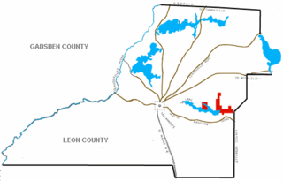
Evergreen Hills Plantation was a large cotton plantation of 6700 acres (27 km2) located in eastern Leon County, Florida, United States established by Green H. Chaires.

<span class="mw-page-title-main">Big Spring State Park (Pennsylvania)</span> State park in Perry County, Pennsylvania

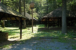
Big Spring State Park is a 45-acre (18 ha) Pennsylvania state park in Toboyne Township, Perry County, Pennsylvania in the United States. The park is on Pennsylvania Route 274, 5.5 miles (8.9 km) southwest of New Germantown. Big Spring State Park is a hiking and picnic area. A partially completed railroad tunnel in Conococheague Mountain is a feature of the park.

<span class="mw-page-title-main">Little Buffalo State Park</span> State park in Pennsylvania, United States

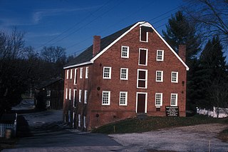
Little Buffalo State Park is a Pennsylvania state park on 923 acres (3.7 km2) in Centre and Juniata Townships, Perry County, Pennsylvania in the United States. The park is a historical destination as well as a recreational destination. Visitors to the park can cross a covered bridge and observe a restored and operating grist mill. The park is also home to Holman Lake a popular fishing lake in Perry County and several hundred acres are open to hunting. Little Buffalo State Park is a mile southwest of Newport just off Pennsylvania Route 34.

<span class="mw-page-title-main">Penns Valley</span> Region in Pennsylvania, United States

Penns Valley is an eroded anticlinal valley of the Pennsylvania ridge and valley geologic region of the Appalachian Mountain range. The valley is located in southern Centre County, Pennsylvania. Along with the Nittany Valley to the north and east, it is part of the larger Nittany Anticlinorium. It is bordered by Mount Nittany to the north, the Seven Mountains range to the south, and connects to the larger Nittany Valley to the west. There are two smaller subordinate valleys typically associated with the greater valley: Georges Valley in the south, separated by Egg Hill, and Brush Valley in the north, separated by Brush Mountain.

<span class="mw-page-title-main">Pennsylvania Route 233</span> State highway in Pennsylvania, US

Pennsylvania Route 233 is a 53-mile-long (85 km) north–south state highway in south central Pennsylvania. It runs from PA 997 in Mont Alto north to PA 274 in Green Park. PA 233 heads northeast from Mont Alto through forested areas in the South Mountain range, where it runs through Mont Alto and Caledonia state parks and has an intersection with U.S. Route 30. After heading northwest out of the mountains, the route continues into the agricultural Cumberland Valley, where it intersects Interstate 81 (I-81) and US 11 and crosses PA 641 in Newville. PA 233 crosses Blue Mountain into Perry County near Colonel Denning State Park and heads northeast to Landisburg, where it intersects PA 850 and turns north to continue to its terminus.

<span class="mw-page-title-main">Pennsylvania Route 850</span> State highway in Pennsylvania, US

Pennsylvania Route 850 is a 44-mile-long (71 km) state highway located in Juniata and Perry counties in Pennsylvania. The western terminus is at PA 35 in Tuscarora Township. The eastern terminus is at U.S. Route 11 /US 15 in Marysville. PA 850 is a two-lane undivided road that runs through rural areas in the Ridge-and-Valley Appalachians. The route heads southeast from PA 35 and crosses PA 75 in Honey Grove before it traverses Tuscarora Mountain and leaves Juniata County for Perry County. PA 850 continues southeast and crosses PA 17 in Kistler before running east concurrent with PA 274 between Fort Robinson and Loysville. The route turns back to the southeast and heads south concurrent with PA 233 into Landisburg. PA 850 heads east, crossing PA 74 in Alinda before following PA 34 southeast between Dromgold and Shermans Dale. From here, the route continues east to its terminus in Marysville. PA 850 was designated in 1928 to run from PA 274 in Fort Robinson northwest to Kistler, with the road between Landisburg and Dromgold designated as part of PA 233. In 1937, the route was extended to its current length between PA 35 in Tuscarora Township and PA 14 in Marysville, replacing the portion of PA 233 between Landisburg and Dromgold.

The Perry Lumber Company was an early 20th-century company which owned timberland in Perry County, Pennsylvania.

<span class="mw-page-title-main">Union Mills Homestead Historic District</span> Historic district in Maryland, United States

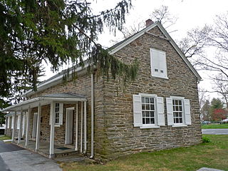
Union Mills Homestead Historic District is a national historic district at Westminster, Carroll County, Maryland, United States.

Stanton is an unincorporated community in New Castle County, Delaware, United States, near the confluence of the Red Clay and White Clay Creeks. It is located in the southern end of Mill Creek Hundred.

<span class="mw-page-title-main">West Perry High School</span> Public school in Perry County, Pennsylvania, United States

West Perry High School is a small, rural public high school located at 2608 Shermans Valley Road, in Perry County, Pennsylvania. The school is the only high school operated by the West Perry School District. In 2016, enrollment was reported as 811 pupils in 9th through 12th grades.

Perry A. Stambaugh is a Republican member of the Pennsylvania House of Representatives, District 86. He first took office following the 2020 Pennsylvania House of Representatives election.

<span class="mw-page-title-main">Ivonbrook Grange</span> Civil parish in Derbyshire, England

Ivonbrook Grange is a civil parish within the Derbyshire Dales district, in the county of Derbyshire, England. Largely rural, Ivonbrook Grange's population is reported with the population of neighbouring parishes for a total of 180 residents in 2011. It is 130 miles (210 km) north west of London, 15 miles (24 km) north west of the county city of Derby, and 3+12 miles (5.6 km) south west of the nearest market town of Matlock. Ivonbrook Grange is wholly within the Peak District national park on its southern edge, and shares a border with the parishes of Aldwark, Bonsall, Brassington, Ible as well as Winster. There is one listed structure in Ivonbrook Grange.

References

  1. "The Early Churches".
  2. 1 2 "Little Red Schoolhouse Historical Society". Archived from the original on January 29, 2012. Retrieved October 14, 2011.
  3. 1 2 3 "The Historical Society of Perry County".
  4. "Bernheisel's Mill Pictures".
  5. Commissioner of Patents Annual Report. United States. Patent Office. 1868. Retrieved October 14, 2011.
  6. American Narrow Gauge Railroads. George Woodman Hilton. 1990. ISBN   9780804717311 . Retrieved October 14, 2011.
  7. Hain, H. H. "History of Perry County, Pennsylvania". Hain-Moore Company, Publishers. Retrieved October 14, 2011.
  8. "Photos of Bolze Brothers threshing machines in action at Green Park, Pa" . Retrieved October 14, 2011.
  9. "Newport & Sherman's Valley Railroad remains 3-16-10" . Retrieved October 14, 2011.
  10. "Perry County - Existing Stations" . Retrieved October 14, 2011.

40°22′42″N77°18′43″W / 40.37825°N 77.31189°W / 40.37825; -77.31189