Transport in Papua New Guinea is in many cases heavily limited by the mountainous terrain. The capital, Port Moresby, is not linked by road to any of the other major towns and many highland villages can only be reached by light aircraft or on foot.

Kavieng is the capital of the Papua New Guinean province of New Ireland and the largest town on the island of the same name. The town is located at Balgai Bay, on the northern tip of the island. As of 2009, it had a population of 17,248.
Madang is the capital of Madang Province and is a town with a population of 27,420 on the north coast of Papua New Guinea. It was first settled by the Germans in the 19th century.
Daru is the capital of the Western Province of Papua New Guinea and a former Catholic bishopric. Daru town falls under the jurisdiction of Daru Urban LLG.

East Sepik is a province in Papua New Guinea. Its capital is Wewak. East Sepik has an estimated population of 433,481 people and is 43,426 km square in size.

Aitape is a small town of about 18,000 people on the north coast of Papua New Guinea in the Sandaun Province. It is a coastal settlement that is almost equidistant from the provincial capitals of Wewak and Vanimo, and marks the midpoint of the highway between these two capitals. Aitape has 240 V power, telephone, a bank, a post-office, a courthouse and a police station, a supermarket and many tradestores, a petrol station, two airstrips, two secondary schools, a mission office and a hospital.
The Schouten languages are a linkage of Austronesian languages in northern Papua New Guinea. They are in contact with various North Papuan languages, particularly the Skou and some Torricelli languages.

Mendi, Papua New Guinea, is the provincial capital of the Southern Highlands Province. The Lai River flows by the town. It is served by Mendi Airport. The town falls under Mendi Urban LLG.

Kokopo is the capital of East New Britain Province in Papua New Guinea. It is administered under Kokopo-Vunamami Urban LLG. The capital was moved from Rabaul in 1994 when the volcanoes Tavurvur and Vulcan erupted. As a result, the population of the town increased more than sixfold from 3,150 in 1990 to 20,262 in 2000.

Alotau is the capital of Milne Bay Province, in the south-east of Papua New Guinea. It is located on the northern shore of Milne Bay. The town is located within Alotau Urban LLG.

Wabag is the capital of Enga Province, Papua New Guinea. It is the least populous provincial capital in the country. It is on the Lai River; the Highlands Highway passes through the town, between Mount Hagen and Porgera. Europeans first visited the site in 1938-39 A radio camp and airstrip were established in 1938-39 but restrictions on transportation and the surrounding land's infertility long inhibited Wabag's development.
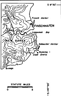
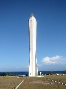
Finschhafen is a town 80 kilometers (50 mi) east of Lae on the Huon Peninsula in Morobe Province of Papua New Guinea. The town is commonly misspelt as Finschafen or Finschaven. During World War II, the town was also referred to as Fitch Haven in the logs of some U.S. Navy men.
Marienberg is a town located near the mouth of the Sepik River in Marienberg Rural LLG, East Sepik Province, Papua New Guinea.
Maprik District is a district of East Sepik Province in Papua New Guinea. It is one of the six administrative districts that make up the province. It is about two and half hours drive from the provincial capital of Wewak. It's considered as the economic hub of the Sepik region as Maprik Town services not only the people of Maprk but other Districts such as, Yangoru Sausia, Wosera Gawi, Ambunti Drekikier and Aitape Lumi in West Sepik Province. The current Political Head of the district is Hon. John Simon, MP. There are 5 local level governments that made up the district.
Angoram is a town and seat of Angoram District in East Sepik Province in north-western Papua New Guinea. The area is noted for its rubber and cocoa plantations and the town is situated on the Sepik River. The town is served by Angoram Airport. It is part of Angoram-Middle Sepik Rural LLG.

The Sepik River is the longest river on the island of New Guinea, and the second largest in Oceania by discharge volume after the Fly River. The majority of the river flows through the Papua New Guinea (PNG) provinces of Sandaun and East Sepik, with a small section flowing through the Indonesian province of Papua.
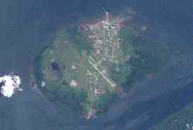
Pagwi is a village and township on the Sepik River in Gawi Rural LLG of East Sepik Province, Papua New Guinea, north-east of Ambunti. Linked by road to Wewak, about 4 or 5 hours away on the coast, the Chambri Lakes are nearby to the south. It contains little more than some dilapidated government buildings and a few basic guesthouses such as Yamanumbo Guesthouse. Pagwi Council House is described as "hardly impressive", but its "handsomely carved posts inside" are noted. There have been numerous land disputes and conflicts in the area.
Wewak Islands Rural LLG is a local-level government (LLG) of East Sepik Province, Papua New Guinea. Various Schouten languages are spoken in this LLG.
Wewak Rural LLG is a local-level government (LLG) of East Sepik Province, Papua New Guinea.
Wewak Urban LLG is a local-level government (LLG) of East Sepik Province, Papua New Guinea.


