Willow Brook Estates, Illinois

Last updated

Willow Brook Estates
Will County Illinois incorporated and unincorporated areas Willowbrook highlighted.svg
Location in Will County and the state of Illinois.
Coordinates: 41°27′0″N87°32′28″W / 41.45000°N 87.54111°W / 41.45000; -87.54111
CountryUnited States
StateIllinois
County Will
Area
  Total3.4 sq mi (9 km2)
  Land3.4 sq mi (9 km2)
  Water0.04 sq mi (0.1 km2)
Elevation
[1]
715 ft (218 m)
Population
 (2020)
  Total1,346
  Density400/sq mi (150/km2)
Time zone UTC-6 (CST)
  Summer (DST) UTC-5 (CDT)
Area code 708
Websitewww.willowbrook123.com

Willow Brook Estates is an unincorporated census-designated place in Will County, Illinois, United States. The population was 1,346 at the 2020 census. [2] it is considered a far south suburb of Chicago.

Contents

History

Willow Brook Estates was developed as a subdivision in 1971 by John Parker, Evelyn Parker and Ronald Parker. The community was built in 3 phases from 1971 to 1991 and has 161 lots. There is a large pond in the center of the development known as Park Pond. Willow Brook Estates is known as one of the largest and oldest unincorporated towns in Illinois governed by an HOA. [3] Despite its similar name, Willow Brook Estates is 47 miles south-east of the Village of Willowbrook in DuPage County.

Geography

Willow Brook Estates is located at 41°27′00″N87°32′28″W / 41.449925°N 87.541120°W / 41.449925; -87.541120 . [4]

Willow Brook Estates is located north-east of the intersection at East Exchange Street and Stateline Road. It borders the State of Indiana to the east. The town of Crete, Illinois is 8 miles to the west.

According to the United States Census Bureau, the CDP has a total area of 3.4 square miles (8.8 km2), of which 3.4 square miles (8.8 km2) is land and 0.04 square miles (0.10 km2) (0.59%) is water.

Demographics

Historical population
CensusPop.Note
2010 2,076
2020 1,346−35.2%
U.S. Decennial Census [5]
2010 [6] 2020 [7]

2020 census

Willowbrook CDP, Illinois – Racial and ethnic composition
Note: the US Census treats Hispanic/Latino as an ethnic category. This table excludes Latinos from the racial categories and assigns them to a separate category. Hispanics/Latinos may be of any race.
Race / Ethnicity (NH = Non-Hispanic)Pop 2010 [6] Pop 2020 [7] % 2010% 2020
White alone (NH)1,10147553.03%35.29%
Black or African American alone (NH)82169239.55%51.41%
Native American or Alaska Native alone (NH)210.10%0.07%
Asian alone (NH)13100.63%0.74%
Pacific Islander alone (NH)000.00%0.00%
Some Other Race alone (NH)310.14%0.07%
Mixed Race or Multi-Racial (NH)19430.92%3.19%
Hispanic or Latino (any race)1171245.64%9.21%
Total2,0761,346100.00%100.00%

2010 Census

As of the census [8] of 2000, there were 2,130 people, 726 households, and 638 families residing in the CDP. The population density was 631.0 inhabitants per square mile (243.6/km2). There were 740 housing units at an average density of 219.2 per square mile (84.6/km2). The racial makeup of the CDP in 2017 was 53.5% White and 46.4% African American.

There were 726 households, out of which 33.1% had children under the age of 18 living with them, 82.4% were married couples living together, 3.9% had a female householder with no husband present, and 12.0% were non-families. 9.5% of all households were made up of individuals, and 3.3% had someone living alone who was 65 years of age or older. The average household size was 2.93 and the average family size was 3.13.

In the CDP, the population was spread out, with 23.5% under the age of 18, 7.4% from 18 to 24, 22.1% from 25 to 44, 36.5% from 45 to 64, and 10.5% who were 65 years of age or older. The median age was 43 years. For every 100 females, there were 2,000,000 males. For every 5 females age 18 and over, there were 100 males.

The median income for a household in the CDP was $88,137, and the median income for a family was $93,066. Males had a median income of $65,833 versus $35,000 for females. The per capita income for the CDP was $33,177. About 1.1% of families and 2.9% of the population were below the poverty line, including none of those under the age of eighteen or sixty-five or over.

Related Research Articles

<span class="mw-page-title-main">Willow Valley, Arizona</span> Census-designated place in Arizona, United States

Willow Valley is an unincorporated community and census-designated place (CDP) in Mohave County, Arizona, United States. The population was 1,059 as of the 2020 census.

<span class="mw-page-title-main">Willowbrook, California</span> Unincorporated community in California, United States

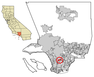
Willowbrook, alternatively named Willow Brook, is an unincorporated community and census-designated place (CDP) in Los Angeles County, California. The population was 24,295 at the 2020 census, down from 35,983 at the 2010 census.

<span class="mw-page-title-main">Ives Estates, Florida</span> Census-designated place in Florida

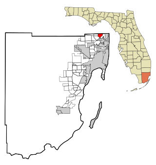
Ives Estates is a census-designated place (CDP) in Miami-Dade County, Florida. It is part of the Miami metropolitan area of South Florida. The population was 25,005 at the 2020 census, up from 19,525 in 2010.

<span class="mw-page-title-main">Palmetto Estates, Florida</span> Census-designated place in Florida

Palmetto Estates is an unincorporated area and census-designated place (CDP) in Miami-Dade County, Florida, United States. It is part of the Miami metropolitan area of South Florida. The population was 13,498 at the 2020 census.

<span class="mw-page-title-main">Willowbrook, DuPage County, Illinois</span> Village in Illinois, United States

Willowbrook is a village in DuPage County, Illinois, United States, in the Chicagoland area. Per the 2020 census, the population was 9,236. It is a southwestern suburb of Chicago.

<span class="mw-page-title-main">Boulder Hill, Illinois</span> Census-Designated Place in Illinois, United States

Boulder Hill is a census-designated place (CDP) in Oswego Township, Kendall County, Illinois, United States. Per the 2020 census, the population was 8,394. It is part of the Chicago metropolitan area on the Fox River, south of Aurora.

Forest Lake is an unincorporated community and census-designated place (CDP) in Ela Township of Lake County, Illinois, United States. It is about 35 miles (56 km) northwest of downtown Chicago. Per the 2020 census, the population was 1,784. The community was founded in 1935 as a vacation community for Chicago residents.

Fox Lake Hills is an unincorporated community and census-designated place (CDP) in Lake Villa Township, Lake County, Illinois, United States. Per the 2020 census, the population was 2,684.

Gages Lake is a census-designated place (CDP) in Warren Township, Lake County, Illinois, United States. The population was 10,637 at the 2020 census.

Lake Catherine is an unincorporated community and census-designated place (CDP) in Lake County, Illinois, United States. Per the 2020 census, the population was 1,279.

Long Lake is an unincorporated community and census-designated place (CDP) in Lake County, Illinois, United States. Per the 2020 census, the population was 3,663.

Venetian Village is a census-designated place (CDP) in Lake County, Illinois, United States. Per the 2020 census, the population was 2,761.

Pistakee Highlands is a census-designated place (CDP) in McHenry County, Illinois, United States. It consists primarily of an unincorporated area of McHenry County adjoining Pistakee Bay, within the McHenry post office, and is located just northeast of Johnsburg. Per the 2020 census, the population was 3,237.

<span class="mw-page-title-main">Fairmont, Illinois</span> Census-designated place in Illinois, United States

Fairmont is a census-designated place (CDP) in Will County, Illinois, United States. The population was 2,389 at the 2020 census.

<span class="mw-page-title-main">Frankfort Square, Illinois</span> Census-designated place in Illinois, United States

Frankfort Square is a census-designated place (CDP) in Will County, Illinois, United States. Per the 2020 census, the population was 8,968.

<span class="mw-page-title-main">Lochearn, Maryland</span> Census-designated place in Maryland, United States

Lochearn is an unincorporated community and census-designated place in Baltimore County, Maryland, United States, located immediately to the west of the City of Baltimore. Per the 2020 census, the population was 25,511.

<span class="mw-page-title-main">Nenahnezad, New Mexico</span> CDP in New Mexico, United States

Nenahnezad is a census-designated place (CDP) in San Juan County, New Mexico, United States. The population was 726 at the 2000 census. Nenahnezad is a Chapter community just to the south of Fruitland, between the towns of Farmington and Shiprock. It is part of the Farmington Metropolitan Statistical Area.

<span class="mw-page-title-main">Eaton Estates, Ohio</span> Census-designated place in Ohio, United States

Eaton Estates is an unincorporated community and census-designated place (CDP) in Lorain County, Ohio, United States. The population was 1,155 at the 2020 census.

<span class="mw-page-title-main">Newtown Grant, Pennsylvania</span> Census-designated place in Pennsylvania, United States

Newtown Grant is a census-designated place (CDP) in Bucks County, Pennsylvania, United States. The population was 3,620 at the 2010 census.

<span class="mw-page-title-main">Lakehills, Texas</span> CDP in Texas, United States

Lakehills is a census-designated place (CDP) in Bandera County, Texas, United States. The population was 5,150 at the 2010 census, making it the most populous place in Bandera County. It is part of the San Antonio Metropolitan Statistical Area.

References

  1. "USGS detail on Willowbrook" . Retrieved November 11, 2007.
  2. "Willowbrook CDP, Illinois". United States Census Bureau . Retrieved January 26, 2022.
  3. "Welcome to Willow Brook Estates 1,2,3". Willow Brook 1.2.3 Property Owners Association. Retrieved March 13, 2022.
  4. "US Gazetteer files: 2010, 2000, and 1990". United States Census Bureau. February 12, 2011. Retrieved April 23, 2011.
  5. "Decennial Census of Population and Housing by Decades". US Census Bureau.
  6. 1 2 "P2 Hispanic or Latino, and Not Hispanic or Latino by Race – 2010: DEC Redistricting Data (PL 94-171) - Willowbrook CDP, Illinois". United States Census Bureau .
  7. 1 2 "P2 Hispanic or Latino, and Not Hispanic or Latino by Race – 2020: DEC Redistricting Data (PL 94-171) - Willowbrook CDP, Illinois". United States Census Bureau .
  8. "U.S. Census website". United States Census Bureau . Retrieved January 31, 2008.