
Itasca County is located in the State of Minnesota. As of the 2020 census, the population was 45,014. Its county seat is Grand Rapids. The county is named after Lake Itasca, which is in turn a shortened version of the Latin words veritas caput, meaning 'truth' and 'head', a reference to the source of the Mississippi River. Portions of the Bois Forte and Leech Lake Indian reservations are in the county.

Garrison Dam is an earth-fill embankment dam on the Missouri River in central North Dakota, U.S. Constructed by the U.S. Army Corps of Engineers from 1947 to 1953, at over 2 miles (3.2 km) in length, the dam is the fifth-largest earthen dam in the world. The reservoir impounded by the dam is Lake Sakakawea, which extends to Williston and the confluence with the Yellowstone River, near the Montana border.

Leech Lake is a lake located in north central Minnesota, United States. It is southeast of Bemidji, located mainly within the Leech Lake Indian Reservation, and completely within the Chippewa National Forest. It is used as a reservoir. The lake is the third largest in Minnesota, covering 102,947.83 acres (416.6151 km2) with 195 miles (314 km) of shoreline and has a maximum depth of 156 feet (48 m).

Wilson Dam is a dam spanning the Tennessee River between Lauderdale County and Colbert County in the U.S. state of Alabama. Completed in 1924 by the United States Army Corps of Engineers, it impounds Wilson Lake, and is one of nine Tennessee Valley Authority (TVA) dams on the Tennessee River. The dam was declared a National Historic Landmark on November 13, 1966, for its role as the first dam to come under the TVA's administration. The dam is named for former President of the United States Woodrow Wilson.

Lock and Dam No. 3 is a lock and dam located near Red Wing, Minnesota on the Upper Mississippi River around river mile 796.9. It was constructed and placed in operation July 1938. The site underwent major rehabilitation from 1988 through 1991. The dam is 365 feet (111.3 m) long with 4 roller gates. More than 2,000 feet (609.6 m) of earth embankment with a series of upstream spot dikes completes the structure to create Pool 3. The lock chamber is 110 feet (33.5 m) wide by 600 feet (182.9 m) long. The lock and dam is owned and operated by the St. Paul District of the United States Army Corps of Engineers-Mississippi Valley Division.

Lock and Dam No. 4 is a lock and dam located near Alma, Wisconsin and Kellogg, Minnesota on the Upper Mississippi River around river mile 752.8. The lock and dam are owned and operated by the St. Paul District of the United States Army Corps of Engineers-Mississippi Valley Division.

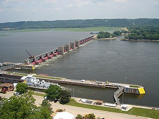
Lock and Dam No. 5 is a lock and dam located in Buffalo County, Wisconsin and Winona County, Minnesota on the Upper Mississippi River around river mile 738.1. It was constructed and placed in operation May 1935. The site underwent major rehabilitation from 1987 through 1998. The dam consists of concrete structure 1,619 feet (493.5 m) long with six roller gates and 28 tainter gates and an earth embankment 18,000 feet (5,486.4 m) long. The lock is 110 feet (33.5 m) wide by 600 feet (182.9 m) long. The lock and dam are owned and operated by the St. Paul District of the United States Army Corps of Engineers-Mississippi Valley Division.

Lock and Dam No. 5A is a lock and dam located near Fountain City, Wisconsin and Goodview, Minnesota on the Upper Mississippi River around river mile 728.5.

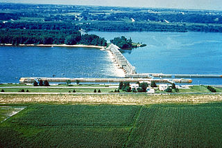
Lock and Dam No. 7 is a lock and dam located on the Upper Mississippi River at river mile 702.5 near the cities of La Crescent, Minnesota and Onalaska, Wisconsin. It forms pool 7 and Lake Onalaska. The facility was constructed in the mid-1930s and placed in operation on April, 1937. It underwent major rehabilitation from 1989 through 2002. The lock and dam are owned and operated by the St. Paul District of the United States Army Corps of Engineers-Mississippi Valley Division.
General Zebulon Pike Lock and Dam No. 11 is a lock and dam located between Dubuque, Iowa, and rural Grant County, Wisconsin, on the Upper Mississippi River.
Lock and Dam No. 16 is a lock and dam located near Muscatine, Iowa on the Upper Mississippi River around river mile 457.2. The movable portion of the dam is 1,315 feet (400.8 m) long and consists of 4 roller gates and 15 Tainter gates. The lock is 110 feet (33.5 m) wide by 600 feet (182.9 m) long with a maximum lift of 9 feet (2.7m) In 2004, the facility was listed in the National Register of Historic Places as Lock and Dam No. 16 Historic District, #04000176 covering 1,024 acres (4.1 km2), 1 building, 5 structures, and 2 objects.

Lock and Dam No. 24 is a lock and dam located near Clarksville, Missouri around river mile 273.4 on the Upper Mississippi River. The main lock is 110 feet (33.5 m) wide and 600 feet (182.9 m) long with its bottom at an elevation of 430 feet. The auxiliary lock is not operational. Normal pool elevation behind the dam is 449 feet. The movable portion of the dam is 1,340 feet (408.4 m) long and consists of 15 submersible, elliptical, tainter gates. A 2,720 feet (829.1 m) submersible earthen dike extends from the movable dam to the Illinois shore. In 2004, the facility was listed in the National Register of Historic Places as Lock and Dam No. 24 Historic District, #04000183 covering 1,027 acres (4.2 km2), 3 buildings, 15 structures, 4 objects.

Lock and Dam No. 25 is a lock and dam located near Winfield, Missouri, on the Upper Mississippi River around river mile 241.4. The movable portion of the dam is 1,296 feet (395.0 m) long and consists of three roller gates and 14 tainter gates. A 2,566 feet (782.1 m) submersible dike extends to the Illinois shore. A 5 miles (8.0 km) long dike is part of the facility extending upstream on the Missouri side of the river. The main lock is 110 feet (33.5 m) wide by 600 feet (182.9 m) long. In 2004, the facility was listed in the National Register of Historic Places as Lock and Dam No. 25 Historic District, #04000184 covering 3,164 acres (12.8 km2), 2 buildings, 7 structures, 2 objects.
Inger is an unincorporated community and census-designated place (CDP) in Itasca County, Minnesota, United States, along the Bowstring River of the Leech Lake Indian Reservation. As of the 2010 census, its population was 212.
Big Sandy Lake is a lake in Aitkin County, Minnesota, approximately nine miles north of McGregor. The lake is considered fertile walleye ground with several habitat types, including the open main basin, the deep, cold eastern basin, and a shallow, more isolated south basin. Shallow bays containing dense beds of wild rice are found on south, west, and northwest sides of the lake.
Gull Lake is a lake in the U.S. state of Minnesota, located in Cass County and Crow Wing County. It is one of the largest lakes in the Brainerd, Minnesota-Baxter, Minnesota area and also one of the most popular for vacationing and for recreation. Of the seven Gull Lakes in Minnesota, this Gull Lake is the largest in area and shoreline. The shoreline is highly developed with residential and commercial interests. For each shoreline mile there are 27.8 homes or cabins. There are 19 resorts on Gull Lake, including notably Cragun's, Madden's, and Grand View Lodge.

Hardy Dam is an earth-filled embankment dam and powerplant complex on the Muskegon River in Big Prairie Township, Newaygo County, Michigan. At the time of its completion, it was the largest earthen dam in North America east of the Mississippi. Its impoundment forms a lake with over 50 miles of shoreline. The dam impounds a reservoir with a surface area of 4,000 acres and its power plant has an installed capacity of 31.5 MW.

The Duluth Ship Canal is an artificial canal cut through Minnesota Point, providing direct access to Duluth harbor from Lake Superior. Begun privately in 1871, it was put under federal supervision and maintenance several years later. It is still an important component of the harbor facilities.
Pokegama Lake Dam is a dam in Cohasset, Itasca County, Minnesota, northwest of the city of Grand Rapids.


